"We warned at the start of ZetaTalk, in 1995, thatunpredictable weather extremes, switching about from drought to deluge,would occur and increase on a lineal basis up until the pole shift. Where this occurred steadily, it has only recently become undeniable. ZetaTalk, and only ZetaTalk, warned of these weather changes, at that early date. Our early warnings spoke to the issue of global heating from the core outward, hardly Global Warming, a surface or atmospheric issue, but caused by consternation in the core. Affected by the approach of Planet X, which was by then starting to zoom rapidly toward the inner solar system for its periodic passage, the core was churning, melting the permafrost and glaciers and riling up volcanoes. When the passage did not occur as expected in 2003 because Planet X had stalled in the inner solar system, we explained the increasing weather irregularities in the context of the global wobble that had ensued - weather wobbles where the Earth is suddenly forced under air masses, churning them. This evolved by 2005 into a looping jet stream, loops breaking away and turning like a tornado to affect the air masses underneath. Meanwhile, on Planet Earth, droughts had become more intractable and deluges positively frightening, temperature swings bringing snow in summer in the tropics and searing heat in Artic regions, with the violence of storms increasing in number and ferocity."
The wobble seems to have changed, as the temperature in Europe suddenly plunged after being like an early Spring, Alaska has its coldest temps ever while the US and much of Canada is having an extremely mild winter. India went from fatal cold spell to balmy again. Has the Earth changed position vs a vs Planet X to cause this?[and from another]Bitter cold records broken in Alaska - all time coldest record nearly broken, but Murphy's Law intervenes[Jan 30]http://wattsupwiththat.com/2012/01/30/bitter-cold-records-broken-in-alaskaJim River, AK closed in on the all time record coldest temperature of -80°F set in 1971, which is not only the Alaska all-time record, but the record for the entire United States. Unfortunately, it seems the battery died in the weather station just at the critical moment. While the continental USA has a mild winter and has set a number of high temperature records in the last week and pundits ponder whether they will be blaming the dreaded "global warming" for those temperatures, Alaska and Canada have been suffering through some of the coldest temperatures on record during the last week.
There has been no change in the wobble pattern, the wobble has merely become more severe. Nancy noted a Figure 8 format when the Earth wobble first became noticeable, in early 2005, after Planet X moved into the inner solar system at the end of 2003. The Figure 8 shifted along to the east a bit on the globe between 2005 and 2009, (the last time Nancy took its measure) as Planet X came closer to the Earth, encountering the magnetic N Pole with a violent push earlier in the day. But the pattern of the Figure 8 remained essentially the same. So what changed recently that the weather patterns became noticeably different in late January, 2012?
The N Pole is pushed away when it comes over the horizon, when the noon Sun is centered over the Pacific. This regularly puts Alaska under colder air, with less sunlight, and thus the historically low temps there this January, 2012 as the wobble has gotten stronger. But by the time the Sun is positioned over India, the N Pole has swung during the Figure 8 so the globe tilts, and this tilt is visible in the weather maps from Asia. The tilt has forced the globe under the hot air closer to the Equator, warming the land along a discernable tilt demarcation line.
The next loop of the Figure 8 swings the globe so that the N Pole moves in the other direction, putting the globe again at a tilt but this time in the other direction. This tilt is discernable in weather maps of Europe, again along a diagonal line. Depending upon air pressure and temperature differences, the weather on either side of this diagonal line may be suddenly warm or suddenly cold. The tilt and diagonal line lingers to affect much of the US and Canada, but the Figure 8 changes at this point to be an up and down motion, pulling the geographic N Pole south so the US is experiencing a warmer than expected winter under a stronger Sun. Then the cycle repeats, with the magnetic N Pole of Earth pushed violently away again as the Sun is positioned over the Pacific.
Would the Zetas be able to let us know what is causing the early break-up of the Arctic Ice, the ice seems to have taken on a swirling pattern at the same time, would this be wobble related?[and from another]http://www.vancouversun.com/news/national/Canada+Arctic+cracks+spec... The ice in Canada’s western Arctic ripped open in a massive “fracturing event” this spring that spread like a wave across 1,000 kilometres of the Beaufort Sea. Huge leads of water – some more than 500 kilometres long and as much as 70 kilometres across – opened up from Alaska to Canada’s Arctic islands as the massive ice sheet cracked as it was pushed around by strong winds and currents. It took just seven days for the fractures to progress across the entire area from west to east.[and from another]http://earthobservatory.nasa.gov/IOTD/view.php?id=80752&src=iot... A high-pressure weather system was parked over the region, producing warmer temperatures and winds that flowed in a southwesterly direction. That fueled the Beaufort Gyre, a wind-driven ocean current that flows clockwise. The gyre was the key force pulling pieces of ice west past Point Barrow, the northern nub of Alaska that protrudes into the Beaufort Sea.
The Figure 8 formed by the N Pole during the daily Earth wobble has shifted somewhat to the East, due to Planet X positioned more to the right of the Earth during its approach. This was anticipated, and well described in ZetaTalk, the Earth crowding to the left in the cup to escape the approach of Planet X, so the angle between these two planets would change slightly. This shift of the Figure 8 to the East is due to the push against the Earth’s magnetic N Pole occurring sooner each day than prior. Thus instead of occurring when the Sun is high over the Pacific, over New Zealand, it is now occurring when the Sun is high over Alaska. All the wobble points have shifted eastward accordingly.
This has brought a lingering Winter to the western US, and a changed sloshing pattern to the Arctic waters. Instead of Pacific waters being pushed through the Bering Straits into the Arctic when the polar push occurs, the wobble is swinging the Arctic to the right, and then later to the left, creating a circular motion in the waters trapped in the Arctic. Since the Earth rotates counterclockwise, the motion also takes this path. This is yet another piece of evidence that the establishment is hard pressed to explain. They are attempting to ascribe this to high pressure and wind, all of which are not new to the Arctic, but this circular early breakup of ice in the Arctic is new.
Let’s face it, this has hardly felt like summer. Now we’ve got the numbers to prove it.
According to the Danish Meteorology Institute (DMI), July is likely to end without a single ‘summer day’, which is defined as any day in which temperatures top 25C (77F) at least somewhere in Denmark.
If the next five days come and go without hitting 25C as predicted, it will mark the first time that Danes will have suffered through a summer-less July in nearly four decades.
“There are only three years in our records in which July contains a big fat zero when it comes to summer days and temps above 25C. That’s 1962, 1974 and 1979,” climatologist John Cappelen said on the DMI website.
DMI’s database goes back to 1874.
The warmest day thus far this month was July 19th, when an almost-yet-not-quite-there 24.6C was recorded. There were only two days in all of June that qualified as a summer day, while May had five.
But meteorologist Klaus Larsen said that all hope is not yet lost.
“The prognoses for the last day of the month - Monday the 31st – are hopping back and forth over the magic point. Until then there are no real signs that we will get over 25C so no matter what we are looking at a meteorological photo finish,” he said.
Unprecedented rainfall: Desert state of Rajasthan records 1466 mm (57.7 inches) in 48 hours
Mount Abu weather station in Sirohi district of India's desert state of Rajasthan received an unprecedented amount of rain on July 25 and 26 with a staggering cumulative of 1 466 mm (57.7 inches) on top of 700 mm (25.5 inches) received on July 23 and 24. While the numbers still need to be verified by officials, it won't mean much for the locals who are already experiencing severe floods and landslides. At least 12 people have been killed across the state, as of early July 26. In the neighboring state of Gujarat, the death toll reached 83, bringing the total to 95 in less than 3 days.
The state of Rajasthan has been witnessing drenching rains over the past couple of days. To such an extent that these showers have wreaked havoc among the locals, distressing normal life as well as road and rail traffic, SkyMet Weather reported July 26.
The reason for these rains could be attributed to the low pressure area which was over Central Rajasthan and at present has shifted to southwestern parts of the state. Further, this system is likely to weaken gradually in the next 24 hours, SkyMet meteorologists said.
According to The Hindu, statistics show that until 2010, the 100-year record for a single-day of rain in Mount Abu was 653 mm (25.7 inches) in 1992. The only comparable deluge after was a 453 mm (17.8 inches) downpour in 2015. In comparison, the torrential rain that brought Mumbai to a standstill in 2005 was 944 mm (37.1 inches) and 644 mm (25.3 inches) on July 26 and 27, whereas Chennai was brought to its knees in 2015 with a cumulative November tally of 1 049 mm (41.2 inches).
According to an article published today by The Times of India, incessant rains since July 21 night have virtually cut off Mount Abu from Gujarat with the hill station plundered by as much as 2 794 mm (110 inches) in just 4 days.
While there has been no major casualty in Abu, Internet broadband connectivity of BSNL and other private telecom operators has been badly hit. Vodafone and Airtel have managed to partially restore the services but BSNL services remained hampered. Though the highway from Abu Road to Mount Abu is clear for traffic, vehicles are moving at a snail's pace and have been asked to exercise caution due to possibilities of landslides and rocks falling from a height. All schools and colleges have been closed as per the order of collector as a precautionary measure.
At least 12 people have been killed across the state between July 24 and early July 26.
The same weather system brought extreme amounts of rain to the neighboring state of Gujarat. In Ahmedabad, Gujarat's main city, more than 10 000 were evacuated to higher ground. 350 villages had been waterlogged, hitting cotton and groundnut crops.
Between July 24 and early July 26, at least 83 people have been killed in the state, bringing the death toll in the two states to 95.
Floods in Gujarat, western India - July 25, 2017. Credit: Narendra Modi
Floods in Gujarat, western India - July 25, 2017. Credit: Narendra Modi
Floods in Gujarat, western India - July 25, 2017. Credit: Narendra Modi
Across the state, more than 36 000 were evacuated and more than 1 600 rescued with the help of Indian Army, Indian Air Force and the National Disaster Response Force since Monday, July 24
Large rainfall leads to flooding in Reed in Gloppen municipality in Sogn og Fjordane and several other places in southern Norway.Photo:
Major flood damage in Western Norway
The storm that hit several places in Norway in night before Monday continues into Tuesday. 50 evacuated in Utvik in Sogn og Fjordane do not know when they will be able to return home.
– The critical phase is over, but there is still high water flow in the rivers in Utvik, says CEO in the West Police District, Odd Arve Solvåg, to NTB.
Several places in Nordfjord in Sogn og Fjordane are hard hit by the rainy weather that started Sunday evening. The showers will continue for several days to come.
– The worst is over, and it becomes ever-decreasing activity by the powerful showers, reassures meteorologist Mariann Foss at the Meteorological Institute.
Utvik isolated – dry in Innvik
In Sogn og Fjordane three places are particularly affected: Sandane and Breim in Gloppen municipality and Utvik in Stryn municipality.
At the measuring station in Stryn it was recorded 15 millimeters in just one hour late Monday. The rainshowers are local, so although Utvik is isolated, there is very little rain 8 kilometers further North, in Innvik.
– The largest rainfall may have come in places without metering stations, according to Foss.
Both rivers that flow through Utvik went over their banks. Thus, the centre of Utvik was completely isolated on Monday, and both electrical power and drinking water were cut off. There are major material damage, but no persons have been injured.
The police inform NTB that 50 people, both tourists and residents, have been evacuated and are waiting for the Norwegian Water Authority’s (NVE) evaluation of the injury level before the evacuees are allowed to return.
– I do not think it’s happening today, Solvåg tells NTB.
County road 60 remains closed at Utvik, two bridges have disappeared and Utvik is therefore without any road to the outside world. The Road Authorities estimate that the road access will be unavailable for one week.
The Civil Defense are assisting
In Breim, the fire department had to rescue two people from an isolated house, and the European Route 39 was closed for several hours with no available detours.
The civil defense moved out to assist the fire department and the police with evacuation and traffic safety in both Breim and Utvik.
– Now it’s all men to the pumps, says Operations Manager in West Police District, Kai Henning Myklebust, to NTB Monday morning.
8 cm rain in one day
Further east, in Gudbrandsdalen, the rain also created major problems. The European route 6 had to be closed for several hours because of a water magazine was about to flood the road.
– We had a lot of water in a short period of time, but it subsided and the water retreated quickly, says Operations Manager in the Inland Police District, Kjartan Waage, to NTB.
In Fåvang in Oppland, the Meteorological Institute recorded 28.3 millimeters in one hour, while Alvdal in Hedmark received 21.8 millimeters of rain in an hour. It hit Norway’s second highest highway hard, the mountain road leading to Tronfjellet in Alvdal. The top two kilometers of the road were washed away by the water mass, and locals estimate the damage to be in the millions, according to newscasters NRK.
The largest amount of precipitation was registered further north, on Venabu. There the meteorologists measured 76.8 millimeters of rainfall in 24 hours
Attention forecast
On Saturday, a notice was issued for five counties in western and central Norway. It is warned about heavy rain showers and danger of local floods. Monday afternoon there is still a Attention Warning for Sogn og Fjordane.
Meteorologist Mariann Foss says to NTB that the inhabitants of Stryn and Gloppen must be prepared for rain for several days to come. On Tuesday the thunderstorms will move onwards to Møre og Romsdal and Trøndelag.
Largest active US wildfire burns 250k acres in Montana
Over 600 firefighters from 34 states have gathered in eastern Montana’s Garfield County to help stop the spread of what is now the largest active fire in the US.
On Tuesday, more than 600 firefighters began fighting the raging Lodgepole Complex fire that has destroyed 250,000 acres of range, brush and timber close to the Missouri River, according to the National Interagency Coordination Center, which gives logistical support for wildland firefighting. The fire has ravaged 22 structures, according to Reuters.
Montana Governor Steve Bullock (R) issued a state fire emergency executive order on Sunday for the wildfire that started last week after a lightning strike. Fortunately, the fire was growing Tuesday at slower rate than previously.
The Lodgepole Complex fire was 36 percent contained by Tuesday evening, and the Garfield County Evacuation Order for people living in the fire zone has been lifted, the Incident Information System reported.
Of the 45 active fires in the US, Lodgepole is the biggest. Relief supplies are being distributed and donated for those who have lost property or experienced any damage from the fire. Volunteers are also preparing food, gathering livestock and mending fences in an effort to help out.
Garfield County spokeswoman Anne Miller said that donations of hay, groceries and money are being sent into the small town of Jordan in Garfield County. "A house is considered a major loss, but the livelihood of most people here is the livestock, the pasture and grazing land," Reuters reported.
Public Information officer Mike Cole says that crews can’t directly attack the fire due to safety concerns, because it is not accessible by road. Managers are now focusing on a longer term strategy for containing the fire. Crews are currently working on the construction of a control line, which will serve as a barrier for homes and the national forest land.
Cole elaborated on the strategy in place to contain the wildfire.
“So once we have this control line in, we are not just going to stop and wait for the fire to come along. We’ll still be working this fire with helicopters and retardant if necessary. We’re going to go back in the forest and find some road systems that are open or we can open up,” he said, Montana Public Radio reported.
Cole said that the fire is expected to grow, but the smoke overhead and the light winds have kept it contained.
The weather forecast for the next several days is hot and dry until Wednesday when a front will approach and bring gusty winds and isolated thunderstorms to the area of the fire. A small amount of rain is also expected. The end of the week will be hot with no rain expected in the forecast, according to Montana National Public Radio.
Comment by jorge namour on July 26, 2017 at 6:31pm
CNN)Parts of the French Riviera were evacuated late Tuesday and into Wednesday as forest fires burned swathes of land and threatened thousands of people, according to local police.
More than 10,000 residents and tourists were moved after a forest fire started near the coastal commune of Bormes-les-Mimosas, around 40 km (nearly 25 miles) from Toulon, one of the country's southernmost towns.
People evacuated from homes and campsites take refuge on the beach in Bormes-les-Mimosas.
A woman inspects the damage following a fire in Bormes-les-Mimosas
Sunbathers lounging on a beach near Saint-Tropez looked on as a wildfire raged nearby. Children played in the sand, while others snapped pictures on their phones, as flames engulfed pine trees and sent plumes of black smoke billowing overhead.
A combination of strong winds, high temperatures, and a lack of rain have fueled the fires, which took hold in the French Riviera and on the island of Corsica, off the southern French coast. Similar conditions have sparked blazes in Portugal and Italy.
Over 100 firefighting operations have been launched since the blazes broke out, with planes flying over the Bormes area since early Wednesday morning, dropping water bombs on the wildfires.
Matthieu Dany, a 23-year-old French designer who has been coming to the area for vacations since he was a child, says he's never seen fires like this
"From our villa in the mountains we can see smoke everywhere. We can see homes burning," Dany told CNN. "I was on the beach earlier, but came back because the fires were getting worse." "Almost everyone on the beach was looking to the hills, taking photos and videos of the fires," he added.
In Londes-les-Maures, fires began to burn just before 11 p.m. local time and, despite the dispatch of 540 firefighters, have not yet been brought under control.
In all, more than 4,000 firefighters and soldiers have been deployed to the region, France's Interior Ministry said in a statement. President Emmanuel Macron shared his support for the firefighters battling blazes on Wednesday.
Comment by Gerard Zwaan on July 25, 2017 at 7:43pm
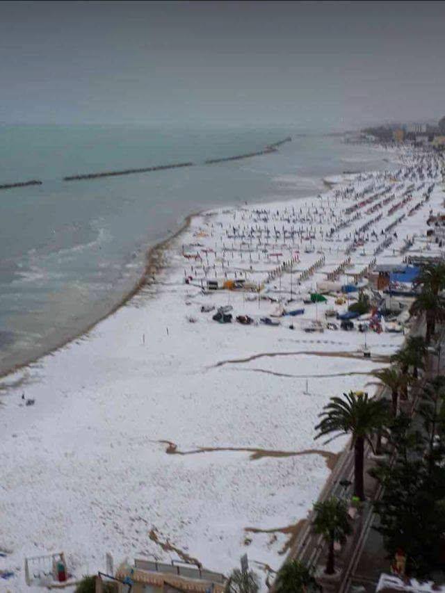
Italian beach turns white after freak hailstorm sweeps across Grottammare (video)
Grottammare on Ice! Today, the beach and roads of the Italian town were blanket with mass amounts of hail at 1:30pm.
Such a freak hailstorm covering the city in 10-15cm of ice with tennis ball sized hail is extremely rare in this coastal region of Italy END OF JULY.
The beach turned white after a freak hailstorm hit Grottammare Italy on July 25 2017 afternoon. via VK.com The freak storm covered the beach with tennis ball sized hail on July 25 2017. via VK.com Not everybody was left baffled by the anomalous weather phenomenon in Grottammare, Italy. via Instagram The hailstorm started at 1:30 pm on July 25 2017 looking like snow on the blanketed beach. via VK.com The powerful thunderstorm swept between San Benedetto del Tronto and Grottammare in Italy. via VK.com Houses damages and flooding have been reported across the affected area along the coast of Italy. via Instagram The flooded streets packed with accumulated hail have triggered a traffic chaos along the Italian Riviera. via instagram Intense thunderstorms swept across most part of central and southern Italy on July 25 2017, the most intense in Marche, Abruzzo and Lazio. via Instagram The hailstorm also destroyed beach material in Grottammare. via VK.com Grottammare was like in Antarctica in middle of the Italian summer. Anomalous! via VK.com
About 16 houses were destroyed in Sukatendel Village by a powerful lahar flowing down the slopes of the eruptive Sinabung volcano in Indonesia.
This new footage of the raging water transporting rocks, ash and mud is just apocalyptic.
The video features a terrifying lahar that flooded a village a day after the eruption of Mount Sinabung on April 18, 2017, after the rain poured the peak of Mount Sinabung at around 13.00 WIB.
Apocalyptical lahar destroys 20 houses after the eruption of Sinabung volcano in Indonesia in 2017
Debris were blocked by a bridge, causing widespread flooding of the nearby main road and in the village.
lahar sinabung volcano indonesia video
The responsible for the Emergency Response Team reported that 20 houses had been affected by the destructive lahar in total and 12 houses had been severely damaged. Emergency works to normalize de river’s flow and clean resident’s houses lasted at least 3 days.
lahar sinabung volcano indonesia video
The video of this desastrous lahar was first shared on Facebook and is soon going to be viral in Europe and the USA.
Two ladies riding with sun protective clothes in Hengshan Road, east China's Shanghai, July 21, 2017. The meteorological department of east China metropolis Shanghai recorded an air temperature of 40.9 degrees Celsius (105.6 degrees Fahrenheit) at around 2 p.m. Friday, the highest on record in the city in 145 years. (Xinhua/Fan Jun)
SHANGHAI, July 21 (Xinhua) -- The meteorological department of east China metropolis Shanghai recorded an air temperature of 40.9 degrees Celsius (105.6 degrees Fahrenheit) at around 2 p.m. Friday, the highest on record in the city in 145 years.
A red alert for high temperatures was issued by the Shanghai Central Meteorological Observatory on Friday.
The previous record high temperature in the city of 40.8 degrees Celsius was recorded on Aug. 7, 2013. A total of 13 high temperature red alerts have been issued since the new meteorological early warning system was adopted in 2007.
China has a three-tier early warning system for high temperatures: a yellow warning is issued when high temperatures above 35 degrees Celsius are predicted for three consecutive days, orange indicates a predicted high temperature of 37 degrees Celsius in the next 24 hours, and a red alert is issued when the temperature is forecast to reach 40 degrees Celsius within 24 hours.
Heat waves have hit the city since the beginning of summer and are expected to linger until the end of July.


 in 48 hours")


 The beach turned white after a freak hailstorm hit Grottammare Italy on July 25 2017 afternoon. via
 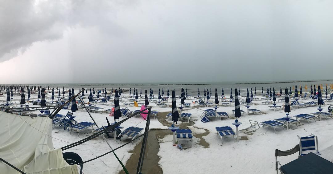 The freak storm covered the beach with tennis ball sized hail on July 25 2017. via
  Not everybody was left baffled by the anomalous weather phenomenon in Grottammare, Italy. via
 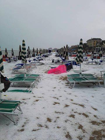 The hailstorm started at 1:30 pm on July 25 2017 looking like snow on the blanketed beach. via
 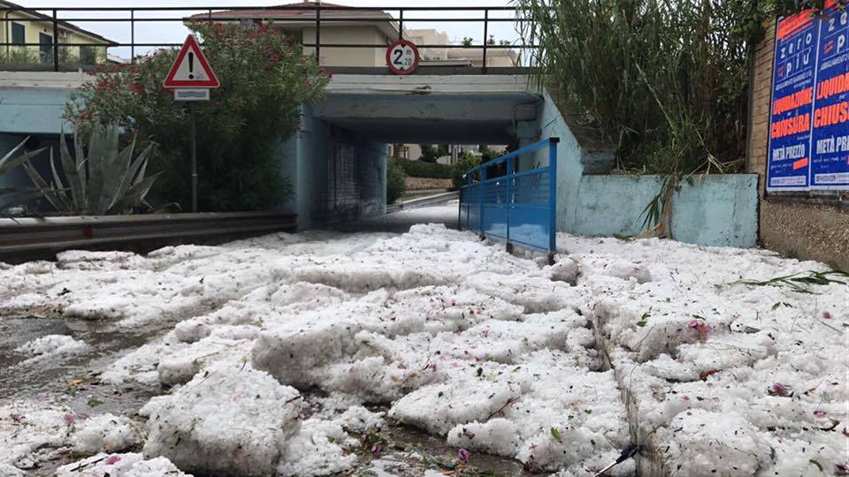 The powerful thunderstorm swept between San Benedetto del Tronto and Grottammare in Italy. via
 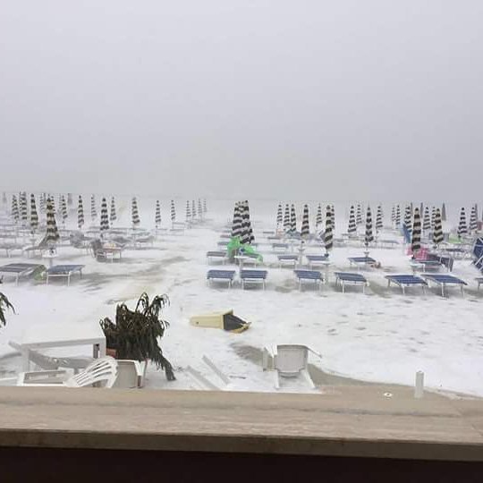 Houses damages and flooding have been reported across the affected area along the coast of Italy. via
 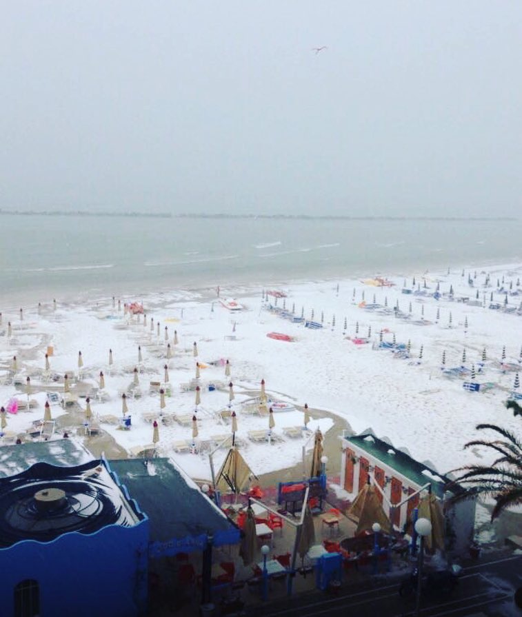 The flooded streets packed with accumulated hail have triggered a traffic chaos along the Italian Riviera. via
 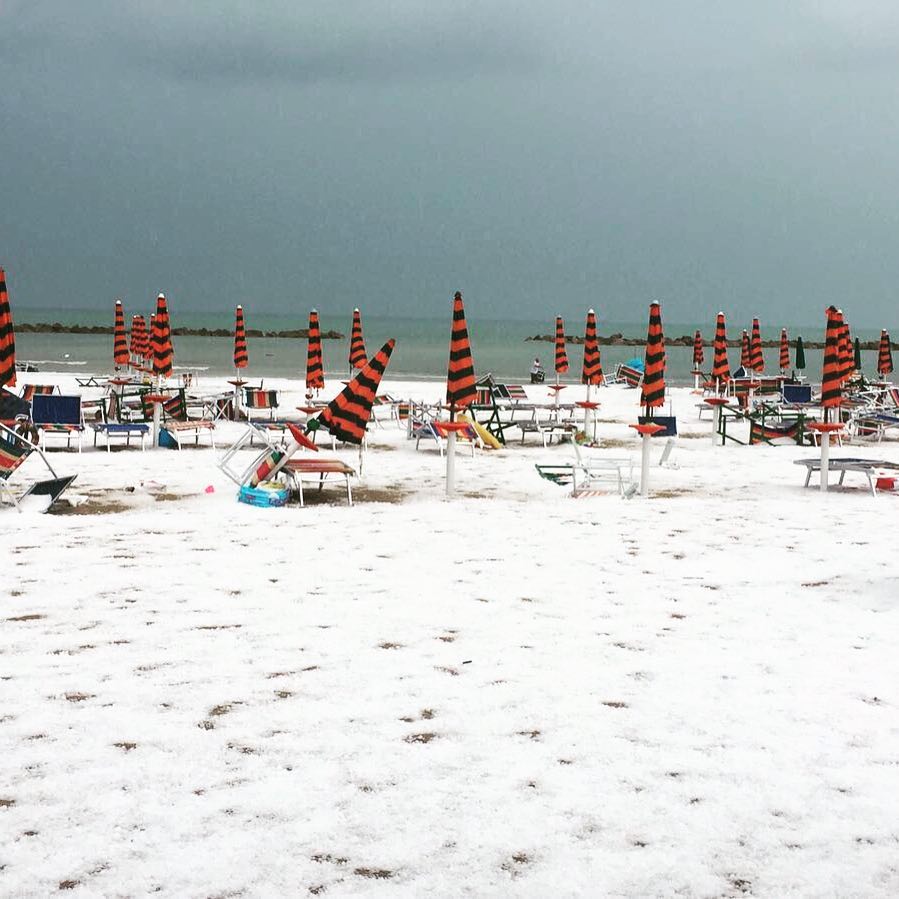 Intense thunderstorms swept across most part of central and southern Italy on July 25 2017, the most intense in Marche, Abruzzo and Lazio. via
 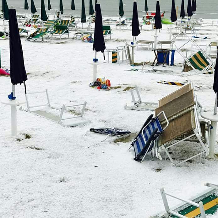 The hailstorm also destroyed beach material in Grottammare. via
 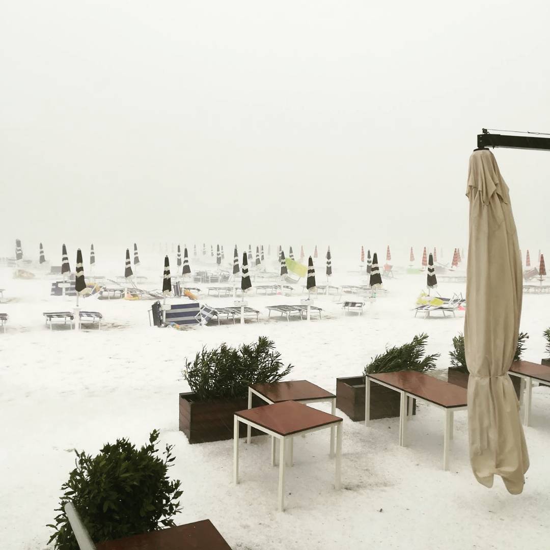 Grottammare was like in Antarctica in middle of the Italian summer. Anomalous! via


 Apocalyptical lahar destroys 20 houses after the eruption of Sinabung volcano in Indonesia in 2017
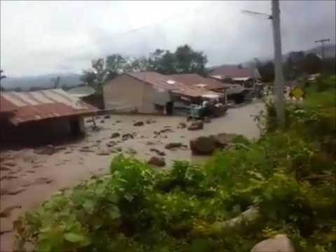 lahar sinabung volcano indonesia video
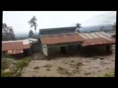 lahar sinabung volcano indonesia video
You need to be a member of Earth Changes and the Pole Shift to add comments!
Join Earth Changes and the Pole Shift