
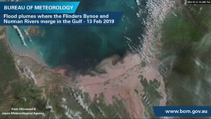
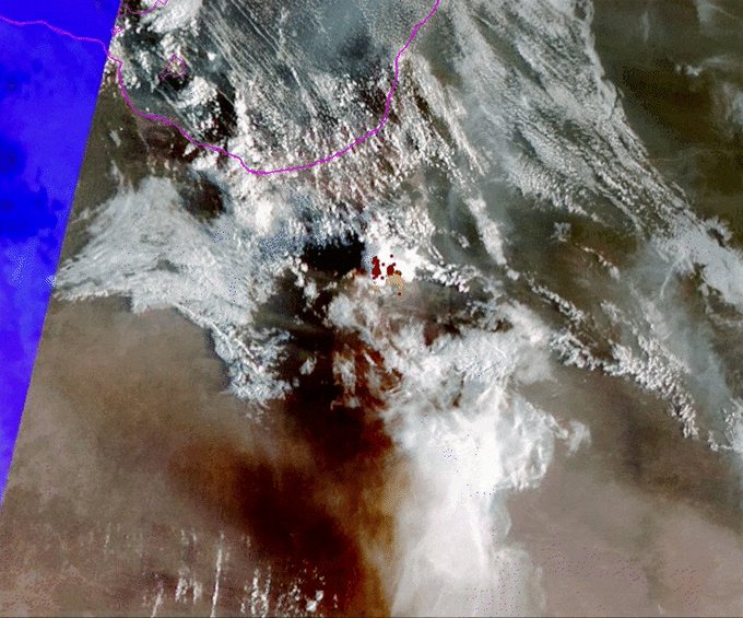
The #FlindersRiver is experiencing its most significant flooding in more than 50 years with major flooding to continue well into next week. Flood plumes spill into the Gulf of Carpentaria as seen from Japan's Himawari-8 satellite: http://ow.ly/JHox50lgL7N
Wild Weather, the Wobble Effect
TOTAL DESTRUCTION IN PARTS OF CEBU CITY, PHILIPPINES, 05.11.25
Massive flooding in Da Nang, Vietnam. 30.10.2025.
Giant waves crash over seawalls during a storm
in the suburbs of Taipei, Taiwan. 21.10.2025
"We warned at the start of ZetaTalk, in 1995, that unpredictable weather extremes, switching about from drought to deluge, would occur and increase on a lineal basis up until the pole shift. Where this occurred steadily, it has only recently become undeniable. ZetaTalk, and only ZetaTalk, warned of these weather changes, at that early date. Our early warnings spoke to the issue of global heating from the core outward, hardly Global Warming, a surface or atmospheric issue, but caused by consternation in the core. Affected by the approach of Planet X, which was by then starting to zoom rapidly toward the inner solar system for its periodic passage, the core was churning, melting the permafrost and glaciers and riling up volcanoes. When the passage did not occur as expected in 2003 because Planet X had stalled in the inner solar system, we explained the increasing weather irregularities in the context of the global wobble that had ensued - weather wobbles where the Earth is suddenly forced under air masses, churning them. This evolved by 2005 into a looping jet stream, loops breaking away and turning like a tornado to affect the air masses underneath. Meanwhile, on Planet Earth, droughts had become more intractable and deluges positively frightening, temperature swings bringing snow in summer in the tropics and searing heat in Arctic regions, with the violence of storms increasing in number and ferocity."
ZETATALK
Wild Weather, the Wobble Effect - Earth Changes and the Pole Shift
Views: 638009
Comment
-
Comment by KM on February 16, 2019 at 4:43pm
-
https://edition.cnn.com/2019/02/14/australia/australia-flinders-riv...
Australian river swells to 37 miles wide due to flooding, creates its own weather system

Satellite imagery shows the massive flooding that has hit northeast Australia in 2019.A river has gone from thin and dry to 37 miles (60 kilometers) wide in a matter of weeks as a result of floods in northeast Australia, satellite imagery shows.
Images released by NASA show the change to the Flinders River -- one of Australia's longest waterways -- over the past month, with flooding there at its worst in more than half a century.
 Bureau of Meteorology, Queensland
CNN meteorologists analyzed the image and said it appeared the river had swelled 60 kilometers wide at some points.
The river is now so big it's creating its own weather system.
The Queensland Bureau of Meteorology (BOM) said extra moisture from the flooding helped create a thunderstorm early Thursday.
Bureau of Meteorology, QueenslandA flood so vast it creates its own weather! The extra moisture from the flooding in #NWQld helped this thunderstorm form this morning. It can be seen following the path of the flood waters very closely, thankfully falls were isolated. More images: http://ow.ly/eCEI30nH35y #BigWet
Australia's billion-dollar beef industry is expected to sustain heavy losses due to the storms. About 500,000 cattle are believed to have died in the flooding, estimated to be to be worth about $213 million (AU$300 million), CNN affiliate Seven News reported.
Many of the cattle carcasses remain, and will pose a health hazard if not buried or burned.
-
Comment by Gerard Zwaan on February 14, 2019 at 12:13pm
-
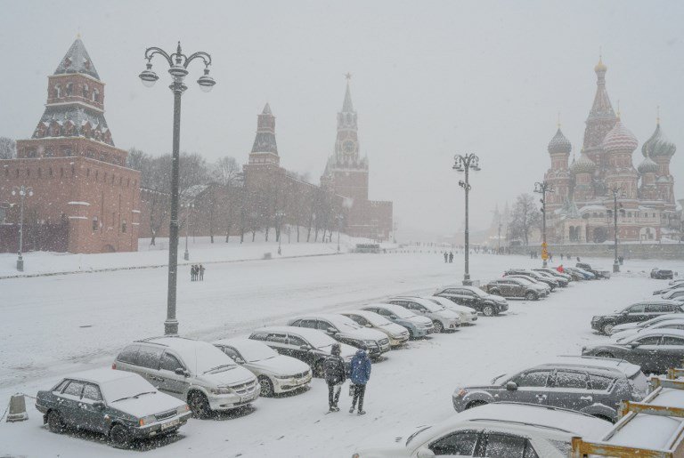
Record-breaking 2019 continues: Moscow suffers record snowfall: California city of 100,000 cut off from record snow: 100,000 without power
Photo newsinfo.inquirer.net
2019 is only 45 days old but we have had record heat, record cold, record rainfall and record snowfall all over the planet and weather records are being broken on an almost daily basis.
The newest area to suffer a record-breaking weather event is Moscow, the capital of Russia.
According to France 24, seven centimetres (2.8 inches) of snow fell overnight, according to the national meteorological service, with drifts reaching up to 45 centimetres (18 inches).
The Moscow meteorological service said the snowfall beat a record set in 1995 and amounted to almost a third of the average monthly figure, according to news agencies.
City authorities said they sent out more than 60,000 people to shovel the snow.
Some 10,000 snow ploughs and 2,000 trucks were dispatched, they added.
The heavy snowfall hit the whole of central Russia but ended in Moscow by nightfall.
Meanwhile, in the US, the California city of Redding, which averages about 3 inches of snow per year, received upwards of a foot of new snow from Nadia, effectively shutting down the city of nearly 100,000.
Roads were impassable and much of the city's homes and businesses lost power as inches of heavy snow weighed down power lines.
"We've been here since 2002 and we've had snow maybe four times, but nothing like this," local resident Chris Belcastro told SF Gate.
According to the Weather Channel, the heavy snow caused numerous power outages; up and down the West Coast, more than 100,000 homes and businesses were in the dark because of Storm Nadia, according to PowerOutage.us.
-
Comment by Juan F Martinez on February 13, 2019 at 9:33pm
-
BRUTAL bombardment with very large hail during yesterday's severe hailstorm in Istanbul, Turkey! Hail up to 9 cm in diameter reported! Video: Meteor Turkey
-
-
The ground started burning on an outback cattle station, per previous Zetatalk this is more Hot Earth
A remote cattle station in the Northern Territory is experiencing an unusual problem with its stock yards.
The ground is on fire and it is proving very difficult to put out. "We doused it with water, but then later that afternoon it started in another spot. "We let it be to see what would happen, and since then there's now another 10 or so spots that have started up and they're slowly spreading."
Melting the thermometer
Mr Martin said the family melted a thermometer while trying to work out how hot the soil was.
"We tried digging [some of] this up with a shovel, but the ground is too hard, it's just baked hard," he said. "We stuck a candy-thermometer in — we could only dig down about 2 inches and it read about 200 degrees Celsius within 30 seconds, and then it just melted the glass."
He said he called a geologist and also rang Bushfires NT to ask if anyone knew what was going on, or if they had seen anything like this before. "Hopefully someone can get back to us with some information about what's happening out here," he said.
"Pouring water onto it doesn't seem to be doing anything."
https://www.abc.net.au/news/rural/2019-02-13/why-is-the-ground-burn...
Hot Earth per Zetatalk : http://poleshift.ning.com/profiles/blogs/zetatalk-newsletter-as-of-...
-
Comment by Starr DiGiacomo on February 12, 2019 at 7:55am
-
https://watchers.news/2019/02/10/hailstorm-destroys-150-homes-injur...
Hailstorm destroys 150 homes, injures 40 people in 60 seconds, India
February 10, 2019 at 18:41 UTC
A fast-moving hailstorm destroyed as many as 150 pucca homes and injured around 40 people in Alivardipur village near Hindon floodplains of Greater Noida, Uttar Pradesh, India on February 7, 2019.
The rain started around 13:50 local time, followed by 60-seconds-long hailstorm around 15:40 and another storm accompanied by high-speed wind. As many as 15 homes were destroyed and over 1 000 people rendered homeless.
Local police said they received first reports of collapsed homes around 19:30 local time.
"Multiple teams of policemen, ambulances, and fire tenders were rushed to the spot. Initially, the police team found 10 - 12 injured people and rushed them to various hospitals in Noida and Greater Noida. The rest were taken to hospitals later."
Residents said they started rescue operation soon after several residents were crushed underneath the piles of bricks.
Local authorities said those affected by the storm are not entitled to any compensation or rehabilitation because all those homes were built illegally.
-
Comment by M. Difato on February 11, 2019 at 6:53pm
-
‘Historic’ storm hurls huge waves and 191-mph winds at Hawaii; rare snow hits Maui
Simulation of storm battering Hawaii on Feb. 10. (VentuSky.com)
An extremely powerful winter storm is pulling away from Hawaii after unleashing damaging winds, massive waves, coastal flooding, and snow in unusual places.
The storm, which the National Weather Service office in Honolulu described as “historic,” began pounding the islands Friday. Hawaii News Now reported a 66-year old California man died in the rough surf off northwest Maui on Friday.
“[Forecasters] are calling this an unprecedented event and we concur that we rarely if ever have seen the combination of record high onshore waves, coupled with gale force winds,” said Sam Lemmo, administrator of Hawaii’s Department of Land and Natural Resources (DLNR).
The storm’s most extreme blow was generated on the Big Island’s towering peak of Mauna Kea where a 191-mph wind gust blasted the mountain summit at 4:40 p.m. local time Sunday.
“That’s the strongest wind gust I’ve ever seen up there,” said Jon Jelsema, senior forecaster at the Weather Service office in Honolulu. “We tend to get a gust maybe to 150 mph once a winter or so, but never 191 mph.”
The visitor station on the 13,308 foot mountain is closed until Tuesday “due to the predicted continuation of severe weather,” according to the station’s website. The road is shut down whenever visibility drops below 50 feet, or winds gust to 65 mph or greater.
Hawaii saw a mixed bag of bizarre precipitation over the weekend as well. Several inches of snow fell on Haleakalā, a shield volcano in East Maui – something Jelsema describes as “very unusual.”
https://twitter.com/reelnewshawaii/status/1094760641158471681
Snow is much more common on the high peaks of the Big Island, at Mauna Kea and Mauna Loa.
The storm even deposited a coating of snow at Maui’s Polipoli State Park at an elevation of just 6,200 feet according to Hawaii’s DLNR.
“[P]erhaps [for] the first time ever, snow has fallen in a Hawai‘i State Park,” the DLNR posted to its Facebook page Sunday. “Polipoli State Park on Maui is blanketed with snow. It could also be the lowest elevation snow ever recorded in the state.”
The vigorous storm triggered rare severe thunderstorm warning for southern Kauai Saturday night.
Wind gusts up to 67 mph were clocked in the oceanside town of Port Allen in Kauai. The community resides on the south side of the island, protected from the harshest conditions streaming in out of the northeast.
Wave heights approached 40 feet just north of Kauai on Sunday.
The National Weather Service had hoisted a high surf warning Thursday in anticipation of the event. It warned of “giant disorganized waves” that “could cause unprecedented coastal flooding Saturday night through Sunday.” Jelsema said his office had received numerous reports of road closures due to the coastal inundation.
“The sea state kind of looks like the water in a washing machine” he said. “You have a mix of swell – which is generated in many different areas of the Pacific – combining with wind waves. One wave follows the next at pretty big intervals.”
Due to strong winds over the weekend, just over 2,400 customers across Hawaii were without power Monday morning, according to PowerOutage.us. That’s down from a peak of nearly 27,000.
The harsh conditions will begin to subside late Monday. The wind advisory in effect for the Big Island expires at noon local time. A high wind warning remains in effect until 6 p.m. local for the Big Island summits of Mauna Kea and Mauna Loa, where gusts may still top 140 mph before tapering down.
Source: https://www.washingtonpost.com/weather/2019/02/11/historic-storm-hu...
-
-
AUSTRALIA This picture taken by a local photographer gives you some indication of the Burnett River level as it swept through Gayndah......the dead cow in the tree didn't stand a chance! Posted by Corey Munson on FB 2-6-2019
-
-
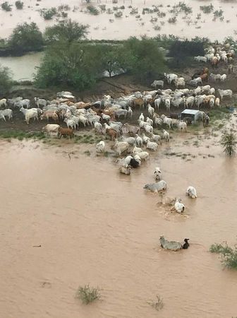
A horror is unfolding in Australia as hundreds of thousands of livestock are dead after a year and a half's rain fell in just seven days
Authorities are beginning to realise the extent of the record-breaking floods in Queensland after more than a year's rain fell in just seven days.
According to Reuters, authorities planned to drop fodder to stranded cattle in Australia’s flooded far north on Friday where vast parts of the outback are under-water and livestock losses are estimated in the hundreds of thousands.
Torrential rains that lashed the coastal city of Townsville in Queensland state this week have swept inland and flooded grazing land gripped by severe drought for years.
Pictures posted on social media showed scores of cattle trapped on patches of high ground surrounded by water, or dead and dying in the mud.
“We’ve had a year and a half of rainfall in about seven days,” cattle grazier Michael Bulley told Reuters by phone from Bindooran Station west of Julia Creek in Queensland’s outback.
Bulley said he flew over his three properties by helicopter and saw water stretching for miles in each direction.
He estimated up to 60 per cent of the cattle he had fed through the drought had been killed by the flooding.
“It’s devastated the country...there’s stock dead everywhere,” he said. “Not just cattle, it’s sheep, kangaroos, wild pigs, they’ve all died and suffered from it.”
The weather bureau said a wide arc of outback stretching some 400 km (250 miles) from Mt. Isa, an outback mining town, to Richmond in the east was inundated. The full scale of the disaster would not be known until the clouds cleared.
-
-
Now the floods! From colder than the Antarctic to Springtime in a couple of days as -40 deg F (-40 deg C) becomes 60 deg F (16 deg C)
Map AccuWeather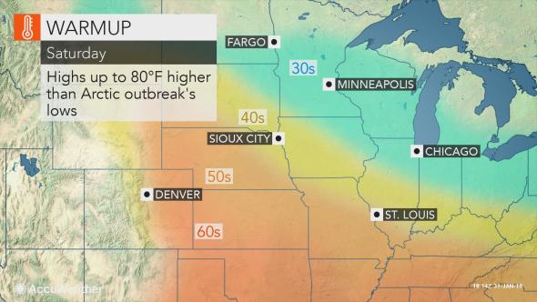
From experiencing the coldest temperature ever recorded with lows colder than the Antarctic and even Mars, temperatures are expected to swing 40 to 80 degrees Fahrenheit, (up to 27 deg C) upward from the lowest levels amid the polar vortex invasion as the midwestern and northeastern United States are treated to a taste of March to start February.
According to AccuWeather, The warmth is also expected to surge across all of the Midwest, mid-Atlantic and into New England Sunday into early next week.
On the warmest day, highs to around 60 (16 deg C) are anticipated northward to the Interstate 70 corridor from St. Louis to Washington, D.C. Even Philadelphia can flirt with the 60-degree mark.
Highs in the 50s may have residents in Chicago, Detroit, New York City and Boston replacing winter jackets with lighter spring attire.
For Chicago, Minneapolis and other parts of the Midwest that endured the harshest cold of the Arctic outbreak, the upswing in temperatures can be as high as 70 to 80 degrees.
A break from the cold is definitely great news for residents dealing with higher heating costs, frozen pipes and animals and kids cooped up due to concerns over frostbite and hypothermia.
"The sudden warmup could lead to ice jam flooding on some rivers as large chunks of ice break loose and jam the flow of water downstream," according to AccuWeather Meteorologist Bill Deger.
Records have been shattered as the polar vortex unleashed the harshest cold in years on the midwestern United States during the final days of January.
After the polar vortex plunged southward, temperatures plummeted under 20 below zero F from North Dakota to northern Illinois during the morning hours of both Wednesday and Thursday.
The low of 38 below zero recorded at Mt. Carroll, Illinois, is being reviewed by a state climate extremes committee to determine if the Illinois state record low was broken on Thursday morning. The current record is 36 below zero that was set near Congerville on Jan. 5, 1999.
-
-
Saudi desert becomes a raging river

Deadly and widespread flooding engulfed the northern and western parts of Saudi Arabia between 27 and 29 January, turning the arid desert into raging rivers.
Civil Defense have rescued over 100 people from flash floods over the last few days in the regions around Tabuk, Jawf, Madinah and Makkah regions.


Source: https://www.earthfrenzyradio.com/earth-changes/4020-saudi-desert-be...
© 2025 Created by 0nin2migqvl32.
Powered by
![]()
You need to be a member of Earth Changes and the Pole Shift to add comments!
Join Earth Changes and the Pole Shift