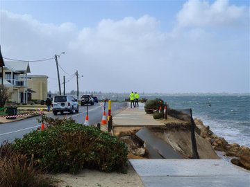
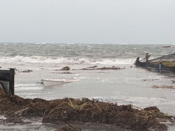
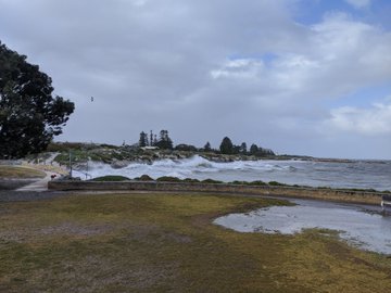
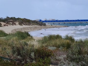
Massive flooding in Da Nang, Vietnam. 30.10.2025.

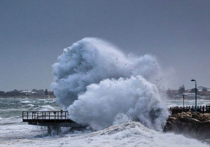
Giant waves crash over seawalls during a storm

in the suburbs of Taipei, Taiwan. 21.10.2025

"We warned at the start of ZetaTalk, in 1995, that unpredictable weather extremes, switching about from drought to deluge, would occur and increase on a lineal basis up until the pole shift. Where this occurred steadily, it has only recently become undeniable. ZetaTalk, and only ZetaTalk, warned of these weather changes, at that early date. Our early warnings spoke to the issue of global heating from the core outward, hardly Global Warming, a surface or atmospheric issue, but caused by consternation in the core. Affected by the approach of Planet X, which was by then starting to zoom rapidly toward the inner solar system for its periodic passage, the core was churning, melting the permafrost and glaciers and riling up volcanoes. When the passage did not occur as expected in 2003 because Planet X had stalled in the inner solar system, we explained the increasing weather irregularities in the context of the global wobble that had ensued - weather wobbles where the Earth is suddenly forced under air masses, churning them. This evolved by 2005 into a looping jet stream, loops breaking away and turning like a tornado to affect the air masses underneath. Meanwhile, on Planet Earth, droughts had become more intractable and deluges positively frightening, temperature swings bringing snow in summer in the tropics and searing heat in Arctic regions, with the violence of storms increasing in number and ferocity."

ZETATALK

Wild Weather, the Wobble Effect - Earth Changes and the Pole Shift

Views: 637745

Comment

You need to be a member of Earth Changes and the Pole Shift to add comments!

Join Earth Changes and the Pole Shift

Comment by Gerard Zwaan on May 27, 2020 at 1:01am

Turkey's eastern provinces hit by disruptive snowstorm and strong winds


Turkey's eastern provinces hit by disruptive snowstorm and strong winds


A cold front accompanied by snow and strong winds caused disruptions to Turkey's eastern provinces beginning Sunday, May 24, 2020. The storm led to extensive damage to properties, power blackouts, traffic interruptions, and at least one person dead.

In the southeastern province of Hakkari, strong winds damaged roofs of houses and public buildings in the city center. A booth serving as a taxi stand was also blown away, rolling into a street.

Homes in Van's city center also took a hit, as well as greenhouses and fields in the nearby districts of Gurpinar, Saray, Gevas, and Ozalp, where a barn's roof collapsed, killing many sheep.

Power blackouts occurred throughout the region, including in Ardahan's city center.

In the city of Kahramanmaras, the storm damaged several apartment buildings, grocery stores, billboards, and a school. In the Nurhak district, a group consisting of 30 people was rescued by the local Disaster and Emergency Management Authority and gendarmerie units.

In the southeastern city of Diyarbakir, rainfall accompanied by hail blanketed streets, leading to whiteout conditions that caused disruptions to drivers exempt from the curfew.

The damage reported in the city center was minimal, however, crops were impacted in the countryside, as well as in the neighboring province of Elazig.

Early Monday, May 25, five neighborhood watchmen sustained injuries in Erzerum's Horasan district. The commuters were on their way home from duty when their car veered off the road.

The country's highlands were also affected by snowfall, especially the northern and eastern parts. High altitude areas in the province of Erzincan were particularly impacted as village roads were blocked, many mountain passes were closed, and drivers had to use tire chains on highways.

At least one fatality was reported, identified as a 70-year-old shepherd. Several cattle breeders in the highlands of the Uzumulu district managed to survive and return to their villages, along with their herd. Baris Metin Kurt, a shepherd, said the weather suddenly became bad, and it is the first time they encountered such an event in May.

In the northern Kastamonu province, a group of shepherds roaming the countryside with 440 sheep were trapped on a plateau following a sudden snowfall. Around 80 sheep perished due to cold and exhaustion, while many remain unaccounted for. Shepherds took refuge in a nearby village with their remaining animals.

In the northern Giersun province, more than a dozen shepherds, along with some 4 000 sheep were rescued in the highlands as local units cleared roads engulfed in snow and brought in fodder.

Featured image credit: Forum Atmosfer/YouTube

Source: https://watchers.news/2020/05/26/turkey-snowstorm-may-2020/

Comment by Juan F Martinez on May 26, 2020 at 5:48pm

MIAMI (CBSMiami) — South Florida’s relentless rain is providing a bit of a break Tuesday morning but more storms are expected Tuesday afternoon and evening.

A Flood watch has been extended until 8;)0 p.m. Tuesday evening because the ground is already saturated and any additional rainfall will lead to more flooding.

https://miami.cbslocal.com/2020/05/26/miami-weather-flood-watch-rem...

Comment by Juan F Martinez on May 26, 2020 at 4:47am

Red Sprites Kansas and Nebraska  5/23/2020

Vía: Space Weather News
https://www.spaceweather.com/
Red Sprites and Blue Jets are known, always associated with lightning and atmospheric turmoil below – storms.     http://www.zetatalk.com/newsletr/issue648.htm
Comment by KM on May 25, 2020 at 4:23pm

https://watchers.news/2020/05/25/extreme-once-in-a-decade-storm-bri...

Extreme 'once-in-a-decade' storm brings destructive winds and rain to Western Australia

Extreme 'once-in-a-decade' storm brings destructive winds and rain to Western Australia


An extreme weather event described as a "once-in-a-decade" brought destructive winds and rain to a wide stretch of Western Australia on May 24 and 25, 2020.

Wind speed of up to 132 km/h (82 mph) was recorded at Cape Leeuwin, the state's strongest May gust in 15 years. In Perth, the wind gusted at more than 90 km/h (56 mph) overnight.

The highest rainfall totals in a 24-hour period to Monday were 60 mm (2.4 inches) at Learmonth Airport and 54 mm (2.1 inches) in Margaret River. Several areas in the Pilbara region received up to 50 mm (2 inches), while up to 20 mm (0.8 inches) soaked agricultural lands.

More than 60 000 homes lost electricity, most of which in the main city of Perth. In an update at 09:00 UTC (17:00 LT) on Monday, Western Power reported that around 4 400 properties remain off supply in the metropolitan area.

In the northern part of the network extending to Geraldton and the Mid West, the number of disrupted homes has been reduced to 1 000, from a peak of 13 000 on Sunday, May 24.

"Our teams have responded to 1 500 incidents over the past 24 hours, with 650 in the metropolitan area alone and nearly 500 hazards identified and assessed," it stated.

Geraldton was hit particularly bad, with debris scattered on streets, windscreens smashed, and several buildings demolished.

Bureau of Meteorology (BOM) manager Neil Bennett said the weather system stretched some 1 200 km (746 miles), also causing some flooding and beach erosion.

"It was really right up and down the coast, including the Perth area, but particularly that southwest area of Western Australia really caught the brunt of this one."

The Canal Rocks walk bridge was reportedly badly damaged by heavy swells and high tides. The area has since been closed to the public.

Pilbara Ports Authority said that while port operations had not been impacted, elevated swell led to some minor changes in the shipping schedule at the Port of Dampier.

Jon Broomhall, Assistant Acting Commissioner of the Department of Fire and Emergency Services, dubbed the storm system a "once-in-a-decade" type. 

The situation was caused by the remnants of Ex-Tropical Cyclone "Mangga" that hit a cold front. "This is a rare event for WA particularly due to the extent of the area affected and the possibility of multiple areas of dangerous weather," said BOM.

The strong winds through #Perth last night whipped up large waves and higher than normal tides causing significant beach erosion along the west coast. A Severe Weather Warning is still current for much of the southwest. http://ow.ly/xLip50zP6Tr 

View image on TwitterView image on TwitterView image on TwitterView image on Twitter
View image on Twitter

While strong wind gusts may still be felt in the Perth metro area, they are no longer expected to be severe or above 90 km/h (56 mph), the weather bureau noted.

A severe weather warning for damaging winds and abnormally high tides is in force for South Coastal, South East Coastal, and parts of South West and Great Southern districts. Marine wind warnings are also in place for some areas, while a severe fire danger warning is forecast for Eucla.

Comment by Juan F Martinez on May 22, 2020 at 9:21pm

The sky of Beijing turns into complete darkness during the afternoon Fri May 22, 2020

22nd May 2020 -(Beijing) Beijing turned into complete darkness at around 3.45pm yesterday. A BBC Camera Journalist, Edward Lawrence based in China who previously produced and shot documentaries captured the bizarre phenomenon. He said that 10 minutes before the darkness, Beijing was still bright with lights.

Another netizen also shared the video of Beijing shrouded in complete darkness on Youtube. A bolt of lightning was seen striking an object before the end of the video. A severe thunderstorm was hitting the city moments later.

"It’s 3.45 in Beijing and ALL OF A SUDDEN IT’S GONE DARK. 10 mins ago, it was light. Now it’s as dark as night." "10-15 mins later is became light again after some heavy rain. Very weird."

https://www.dimsumdaily.hk/beijing-turns-into-complete-darkness-dur...

https://twitter.com/EP_Lawrence?ref_src=twsrc%5Etfw%7Ctwcamp%5Etwee...

Comment by jorge namour on May 22, 2020 at 4:37pm
Comment by KM on May 21, 2020 at 5:14pm

https://www.thebigwobble.org/2020/05/i-have-never-seen-such-cyclone...

“I have never seen such a cyclone in my life. It seemed like the end of the world. All I could do was to pray." Death toll approaches 100 as “Super Cyclonic Storm Amphan hits India and Bangladesh


People make way through gusty winds as super cyclone Amphan makes landfall, near Dhamara Port in Bhadrak district. (PTI) Hindu Times

The most powerful cyclone to strike eastern India and Bangladesh in over a decade has killed 84 people with many missing after a powerful cyclone tore through coastal areas and neighbouring Bangladesh, a state chief minister said on Thursday. The cyclone struck the state of West Bengal on Wednesday evening, devastating villages, tearing down power lines, and leaving large tracts of land underwater. State Chief Minister Mamata Banerjee said the death toll stood at 84 with most caused by electrocution and falling trees. Bangladesh, where the cyclone moved on to, has so far reported 10 deaths.

Mass evacuations organised by authorities before Cyclone Amphan made landfall undoubtedly saved countless lives, but the full extent of the casualties and damage to property would only be known once communications were restored, officials said.

“I have never seen such a cyclone in my life. It seemed like the end of the world. All I could do was to pray... Almighty Allah saved us,” Azgar Ali, 49, a resident of Satkhira district on the Bangladesh coast told Reuters. At one point 14 million people were without power in the city of Kolkata. Many thousands of people have been evacuated causing a massive problem for people safe-distancing due to the Covid-19 Pandemic.

Tropical cyclone Amphan (Bay of Bengal) was one of the most intense Category 5 storms on record in the North Indian Ocean. A “Super Cyclonic Storm” – the equivalent of a Category 5 hurricane on the Saffir Simpson scale.

The deadliest tropical cyclone on record, the Great Bhola Cyclone in November 1970, killed at least 300,000 people in modern-day Bangladesh and led to the establishment in 1972, of a body in charge of the regional coordination mechanism for tropical cyclones, the WMO/ESCAP Panel on Tropical Cyclones Extensive and coordinated disaster risk reduction campaigns have, in recent years, limited casualties.
Comment by KM on May 15, 2020 at 6:12am

https://www.youtube.com/watch?v=VZ-LNoL0m-k


Took the roof off

Extreme hurricanic winds and flying debris in Russia

Embedded video

Comment by Gerard Zwaan on May 10, 2020 at 11:52am

Polar vortex brings May snow and freeze warnings to New York and New England

Peter and Joanna Brown walk their dog in West Paris, Maine, on Saturday.
Peter and Joanna Brown walk their dog in West Paris, Maine, on Saturday. Photograph: Andree Kehn/AP
Associated Press in Boston
Published onSat 9 May 2020 19.55 BST

Mother’s Day weekend got off to an unseasonably snowy start in the US north-east on Saturday, thanks to the polar vortex bringing cold air down from the north.

Some higher elevation areas in northern New York state and New England reported snowfall accumulations of up to 10in, while traces of snow were seen along the coast from Maine to Boston and as far south as Manhattan.

John Cannon, a meteorologist with the National Weather Service (NWS) in Gray, Maine, said parts of northern New England saw as much as 10in of snow and coastal areas of Maine and New Hampshire got a dusting. There were even reports of flurries in Boston.

“We’ve had several inches in many areas in the north-east. This is a rare May snow event,” he said.

The hardest-hit areas were hill town communities like Sugar Hill, New Hampshire, which got 10.5in, and Carrabasset Valley in Maine, which got 9in, he said.

Conditions at the Mount Washington Observatory, atop the highest peak in the north-east, were downright arctic on Saturday afternoon, with the wind chill at -22F (-30C) and winds gusting at 87mph.

In many areas, the snowfall was one for the record books, even if it didn’t stick around. Massachusetts had not seen measurable snow in May since 2002, while in Manhattan’s Central Park, the flakes tied a record set in 1977 for latest snow of the season.

The wintry weather came two days after Vermont began to lift restrictions on tennis, golf and other outdoor activities that had been imposed to curb the coronavirus outbreak. Phil Scott, the state’s governor, tweeted sympathy to Vermonters frustrated by the weather following weeks of being inside.

“I know snow on 9 May isn’t a welcome sight for many Vermonters, just as we’re cautiously allowing outdoor recreation to get going again,” he wrote. “But this is just a snapshot in time. Just like better weather is ahead, better days will come, as well. We will get through this, together.”

Usually the polar vortex is a batch of cold air that stays trapped in the Arctic all winter, but a couple times during the season it wanders south and brings bone-chilling cold and snow to Canada and parts of the US.

A low pressure system off the coast of southern New England helped pull cold air down from the north, said lan Dunham, a meteorologist with the NWS in Norton, Massachusetts.

Cannon said the snow would give way to strong winds upward of 40mph and 50mph in much of the US north-east for the remainder of Saturday, along with unusually cold conditions. There were freeze watches and warnings out for much of the region.

Temperatures were expected to dip below 30F (-1C) from midnight through Sunday morning in parts of New Jersey and New York and a freeze warning was issued from Saturday night until Sunday morning in parts of Pennsylvania.

Source: https://www.theguardian.com/us-news/2020/may/09/polar-vortex-brings...

Comment by KM on May 5, 2020 at 5:41pm

https://www.mthotham.com.au/discover/connect-with-us/latest-news/ap...

AUTUMN'S WINTERY BLAST

A once-in-a-decade dump of 80cm+ of snow in early May at Hotham!

Let it snow!

02/05/2020

It's continued snowing lightly all day and we now have over 80cm+ from this remarkable Autumn snowstorm.

Some of the windrifts are over a metre deep! The table-o-metre has nearly disappeared and checkout the breathtaking images in our gallery.

Let's take it all in from our lounge rooms as we remind you that 'stay at home' restrictions remain in place in Victoria until 11 May 2020.

01/05/2020

Mid-winter conditions on the first day of May today at Hotham! An unbelievable dump of 50cm+ in the last 24 hours has seen the snow pillows on the table-o-metre growing by the hour.

With blizzard conditions today, the flakes continue to fall heavily and we could be in for another 15-20cm from this incredible Autumn snowstorm.

30/04/2020

Mother nature has forgotten we’re still in April, delivering a once-in-a-decade Autumn snowstorm with a bang at Hotham. With wet weather all through Victoria, frigid alpine temperatures have blanketed Hotham in 15cm of snow over the last 12 hours. And this is only the entrée, with another 40cm or more still on the way!

It’s continued snowing steadily today with the forecast calling for snow to intensify tonight and all through tomorrow.  Blizzard-like conditions at Hotham on Friday will see a maximum temperature of -3C and winds up to 55 kilometres per hour.

With snow showers not easing until Saturday morning, stay home with a Hot(ham) chocolate, rug up and tune in to our snow cams to watch the snow build up!

Snow Hotham
Family
Harry 2
May Snow Tables 2020
May Snow Hotham Heights
Thigh Deep Snow May 2020
Trees and Car in May snow 2020
May Snow Husky 2020
Family

SEARCH PS Ning or Zetatalk

 
Search:

This free script provided by
JavaScript Kit

Donate

Donate to support Pole Shift ning costs. Thank you!

© 2025   Created by 0nin2migqvl32.   Powered by

Badges  |  Report an Issue  |  Terms of Service