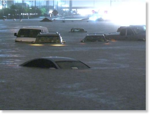
"We warned at the start of ZetaTalk, in 1995, thatunpredictable weather extremes, switching about from drought to deluge,would occur and increase on a lineal basis up until the pole shift. Where this occurred steadily, it has only recently become undeniable. ZetaTalk, and only ZetaTalk, warned of these weather changes, at that early date. Our early warnings spoke to the issue of global heating from the core outward, hardly Global Warming, a surface or atmospheric issue, but caused by consternation in the core. Affected by the approach of Planet X, which was by then starting to zoom rapidly toward the inner solar system for its periodic passage, the core was churning, melting the permafrost and glaciers and riling up volcanoes. When the passage did not occur as expected in 2003 because Planet X had stalled in the inner solar system, we explained the increasing weather irregularities in the context of the global wobble that had ensued - weather wobbles where the Earth is suddenly forced under air masses, churning them. This evolved by 2005 into a looping jet stream, loops breaking away and turning like a tornado to affect the air masses underneath. Meanwhile, on Planet Earth, droughts had become more intractable and deluges positively frightening, temperature swings bringing snow in summer in the tropics and searing heat in Artic regions, with the violence of storms increasing in number and ferocity."
The wobble seems to have changed, as the temperature in Europe suddenly plunged after being like an early Spring, Alaska has its coldest temps ever while the US and much of Canada is having an extremely mild winter. India went from fatal cold spell to balmy again. Has the Earth changed position vs a vs Planet X to cause this?[and from another]Bitter cold records broken in Alaska - all time coldest record nearly broken, but Murphy's Law intervenes[Jan 30]http://wattsupwiththat.com/2012/01/30/bitter-cold-records-broken-in-alaskaJim River, AK closed in on the all time record coldest temperature of -80°F set in 1971, which is not only the Alaska all-time record, but the record for the entire United States. Unfortunately, it seems the battery died in the weather station just at the critical moment. While the continental USA has a mild winter and has set a number of high temperature records in the last week and pundits ponder whether they will be blaming the dreaded "global warming" for those temperatures, Alaska and Canada have been suffering through some of the coldest temperatures on record during the last week.
There has been no change in the wobble pattern, the wobble has merely become more severe. Nancy noted a Figure 8 format when the Earth wobble first became noticeable, in early 2005, after Planet X moved into the inner solar system at the end of 2003. The Figure 8 shifted along to the east a bit on the globe between 2005 and 2009, (the last time Nancy took its measure) as Planet X came closer to the Earth, encountering the magnetic N Pole with a violent push earlier in the day. But the pattern of the Figure 8 remained essentially the same. So what changed recently that the weather patterns became noticeably different in late January, 2012?
The N Pole is pushed away when it comes over the horizon, when the noon Sun is centered over the Pacific. This regularly puts Alaska under colder air, with less sunlight, and thus the historically low temps there this January, 2012 as the wobble has gotten stronger. But by the time the Sun is positioned over India, the N Pole has swung during the Figure 8 so the globe tilts, and this tilt is visible in the weather maps from Asia. The tilt has forced the globe under the hot air closer to the Equator, warming the land along a discernable tilt demarcation line.
The next loop of the Figure 8 swings the globe so that the N Pole moves in the other direction, putting the globe again at a tilt but this time in the other direction. This tilt is discernable in weather maps of Europe, again along a diagonal line. Depending upon air pressure and temperature differences, the weather on either side of this diagonal line may be suddenly warm or suddenly cold. The tilt and diagonal line lingers to affect much of the US and Canada, but the Figure 8 changes at this point to be an up and down motion, pulling the geographic N Pole south so the US is experiencing a warmer than expected winter under a stronger Sun. Then the cycle repeats, with the magnetic N Pole of Earth pushed violently away again as the Sun is positioned over the Pacific.
Would the Zetas be able to let us know what is causing the early break-up of the Arctic Ice, the ice seems to have taken on a swirling pattern at the same time, would this be wobble related?[and from another]http://www.vancouversun.com/news/national/Canada+Arctic+cracks+spec... The ice in Canada’s western Arctic ripped open in a massive “fracturing event” this spring that spread like a wave across 1,000 kilometres of the Beaufort Sea. Huge leads of water – some more than 500 kilometres long and as much as 70 kilometres across – opened up from Alaska to Canada’s Arctic islands as the massive ice sheet cracked as it was pushed around by strong winds and currents. It took just seven days for the fractures to progress across the entire area from west to east.[and from another]http://earthobservatory.nasa.gov/IOTD/view.php?id=80752&src=iot... A high-pressure weather system was parked over the region, producing warmer temperatures and winds that flowed in a southwesterly direction. That fueled the Beaufort Gyre, a wind-driven ocean current that flows clockwise. The gyre was the key force pulling pieces of ice west past Point Barrow, the northern nub of Alaska that protrudes into the Beaufort Sea.
The Figure 8 formed by the N Pole during the daily Earth wobble has shifted somewhat to the East, due to Planet X positioned more to the right of the Earth during its approach. This was anticipated, and well described in ZetaTalk, the Earth crowding to the left in the cup to escape the approach of Planet X, so the angle between these two planets would change slightly. This shift of the Figure 8 to the East is due to the push against the Earth’s magnetic N Pole occurring sooner each day than prior. Thus instead of occurring when the Sun is high over the Pacific, over New Zealand, it is now occurring when the Sun is high over Alaska. All the wobble points have shifted eastward accordingly.
This has brought a lingering Winter to the western US, and a changed sloshing pattern to the Arctic waters. Instead of Pacific waters being pushed through the Bering Straits into the Arctic when the polar push occurs, the wobble is swinging the Arctic to the right, and then later to the left, creating a circular motion in the waters trapped in the Arctic. Since the Earth rotates counterclockwise, the motion also takes this path. This is yet another piece of evidence that the establishment is hard pressed to explain. They are attempting to ascribe this to high pressure and wind, all of which are not new to the Arctic, but this circular early breakup of ice in the Arctic is new.
Saint John declares state of emergency after brawny blizzard buries Maritimes
Andrew Vaughan / Canadian Press employee clears a path in downtown Moncton, N.B., on Monday. The Atlantic region is experiencing a wide range of severe weather including heavy snow, high winds and flash freezing.
SAINT JOHN, N.B. — The city of Saint John, N.B., has declared a state of emergency after a brawny blizzard dumped 29 centimetres of snow on a city that already had almost 100 centimetres of snow on the ground.
With more snow in the forecast, city officials said public safety was at risk as emergency were having a tough time getting around in the city’s southern peninsula. The city has banned all street parking on the peninsula and is warning their vehicles will be towed as of noon today.
“The declaration is a result of the current heavy snow accumulation and anticipated further accumulation and the need to have accessibility for public safety,” the city said in a statement. “The purpose of this declaration is to support more effective snow plowing, push back and removal.”
The Trans-Canada Highway between Moncton and Nova Scotia has been closed, as have some roads along the coast in eastern New Brunswick.
“It’s been difficult to keep up with the rate of snowfall,” said Jean-Marc Couturier, a forecaster with Environment Canada in Halifax.
Environment Canada says a low pressure system has tracked northeastward over the Maritimes, bringing heavy snow, strong northeast winds and wind-chill values near -30 C.
Road closures, school cancellations and were reported across the region.
In Charlottetown, the storm dumped 59 centimetres of snow. Moncton reported 44 centimetres.
In northern Nova Scotia, another 20 to 30 centimetres of snow fell on the area with Greenwood, N.S., getting the most at 34 centimetres.
The streets of Halifax were slippery this morning after ice pellets and freezing rain combined to a frozen mess. Both Halifax and Yarmouth reported 24 centimetres of snow.
“There was a mixed bag of precipitation throughout Nova Scotia,” says Couturier.
Meanwhile, winds gusting at more that 100 kilometres per hour have been reported in parts of Cape Breton.
The storm was expected to make its way to Newfoundland and Labrador later today, bringing high winds and heavy snow to some areas.
Couturier says another low-pressure system is expected to hit the Maritime on Thursday, bringing more snow and strong winds.
2 Dead, 5,000 Homes Damaged after Floods and Landslides in Indonesia
Heavy rainfall across Indonesia has caused flooding and landslides, resulting in the death of at least 2 people and damage to over 5,000 homes.
Bali
Floods and landslides killed two people in Karangasem district, Karangasem, Bali on 31 January 2015. Two others were injured in the landslide which occurred after heavy rainfall in the region.
West Nusa Tenggara
Floods have damaged at least 4,000 houses in the Dompu and Woja districts, West Nusa Tenggara.
The flood inundated between 4,000 and 5,000 houses in the area. Some houses on riverbanks encountered floodwaters 4 meters deep, nearly submerging them.
The overflowing Laju, Silo, Soa, Raba Baka and Toi rivers were blamed for the flood in Dompu.
East Java
Major flooding has hit a number of villages in Bojonegoro, East , over the last several days due to overflow from nearby rivers, including Mekuris and Pancal. Some areas are said to be under 80 cm of water. Around 50 houses and a health centre have been damaged by the floods in Gondang.
Around 7,000 people in Nganjuk regency have been cut off after floods caused a bridge in Sawahan district to collapse.
South and Central Kalimantan
Heavy rain forced the Benawa and Barabai rivers to overflow in South Kalimantan, flooding of Batu Benawa and Barabai districts.
WMO report that 109 mm of rain fell in 24 hours to 02 February 2015 in Pangkalan Bun, Central Kalimantan.
Jakarta
Several areas of Jakarta are again underwater after 2 days of heavy rain across the capital. Kampung Pulo in East Jakarta and Duri Kosambi in West Jakarta and Petogogan, Kebayoran Baru in South Jakarta are said to be worst hit.
WMO report that 104 mm of rain fell over a 24 hour period to 02 February 2015 in Tanjung Priok, Jakarta.
Further Heavy Rainfall
Indonesia’s Meteorology, Climatology and Geophysics Agency (BMKG) warned there could be worse to come as the peak of the rainy season is to hit.
Indonesia’s National Disaster Mitigation Agency (BNPB) called on people to exercise caution during the current spate of severe weather.
Provinces with high potential for heavy downpours over the next three days include West Nusa Tenggara, Lampung, West Java, Central Java, East Java, Central Kalimantan, South Sulawesi, Southeast Sulawesi, Bali, East Nusa Tenggara, Maluku and Papua.
Comment by SongStar101 on February 1, 2015 at 7:45am
Warm weather, lack of snow has Alaska sled dog races scrambling
Snow appears to be in Alaska's forecast, but sled dog races are still pondering serious trail re-routes or cancelations due to the lack of winter weather.
The Iditarod Trail Sled Dog Race is considering moving its restart to Fairbanks. The Yukon Quest from Whitehorse to Fairbanks is looking at moving its start due to open water on the Yukon River not far from the Whitehorse. Every sprint race in Anchorage has been canceled due to lack of snow. Numerous mid-distance races across the state are hanging on, hoping that weather improves enough to make the races safe.
Take, for example, the Northern Lights 300. Race Manager Sue Allen said the weather was “certainly affecting” the race, scheduled to start Friday. Lack of snow is the biggest concern right now, she said, noting that the course, which starts at Martin Buser’s Happy Trails Kennel outside of Big Lake, has a “ribbon of ice” on it and “some nice hoar frost.”
“It’s really bad when we’re counting hoar frost as accumulation,” Allen said. “At this point, every little bit helps.”
Allen said Tuesday that 20 of the 38 mushers signed up for the race were attempting to qualify for the Iditarod. The Northern Lights race serves as one of the few 300-mile races in Alaska -- a distance any musher hoping to run a 1,000-mile race must first complete. The Northern Lights race does not offer prizes for winning, but many mushers' main goal is finishing.
Allen admitted she was slightly nervous sending all the new mushers out on a lousy trail. The race has already reduced the maximum number of dogs from 14 to 12 in an effort to slow teams down. She said they plan to ask racers to carry blocks of ice with them to melt for water, since there’s not enough snow accumulation to melt for drinking water.
The decision to cancel is a tough call this year. Last year Allen had to cancel the race the day before the start due to rain.
Allen said it’s especially hard to see people working toward their dream of racing in the Iditarod hurt by the difficulty of getting into a qualifying race. Still, safety is a priority.
“We want people to go out and have a really good time,” Allen said. “But it’s really hard to have to a good time when you’ve shaken all your teeth out of your head.”
Knik 200 Race Manager Bob Sexton noted that his race, which traditionally starts on Knik Lake, is considering a move to Willow’s Deshka Landing because of poor trail conditions. There’s concern that even the lake -- a former Iditarod checkpoint -- doesn’t have enough ice to hold all the dog trucks that usually park on the lake ice.
“It’s unbelievable this year,” Sexton said, noting that race officials would make a call Wednesday night on whether to move the race or cancel it.
Sexton said this year’s Knik 200 field of 40 filled up in 38 minutes.
“So many people are trying to qualify for races, and the races get canceled or they can’t get into the others," Sexton said. "It starts compiling.”
The Tustumena 200 on the Kenai Peninsula is hoping it can finally host the 30th running of its race after also canceling in 2014. As of Tuesday, things weren’t looking great.
“As of today, we have no trail,” said Race Director Tami Murray.
The race has already been moved from Feb. 7 to Feb. 21. Murray said the race wouldn’t make a decision about whether or not to go until closer to the start date.
“We’re ready, we're just waiting for the snow to make an appearance,” she said.
So are sprint racers. John Rasmussen, manager for the Alaska Sled Dog and Racing Association said no one in Anchorage has even been able to train their dogs on the icy, tussocky trails of the Tozier Track off Tudor Road, let alone race on them. He said mushers don’t even show up to the weekly meetings anymore; there’s no reason to until more snow falls.
But Jeff Barney, executive director of the Anchorage’s Fur Rendezvous, which hosts the Open World Championship, wasn’t too concerned Wednesday. He said a lack of snow is always a concern for organizers of the sprint race, but with more than a month to go, he wasn’t worried yet.
“We’re definitely just waiting,” Barney said. “It seems to always work out.”
Anna Berington mushes down a snow-starved section of the Iditarod Trail in the middle of the Farewell Burn during the 2014 Iditarod Trail Sled Dog Race. This year has seen even less snow, prompting race organizers across the state to consider postponing, moving or canceling races.
Comment by jorge namour on January 30, 2015 at 1:32pm
The polar vortex plunges to France
News - Updated Friday, January 30, 2015 by The Weather Channel- La Chaîne Météo
The polar vortex, the term was widely publicized during cold waves were recorded for the United States, will experience a drop from the Arctic and will plunge towards France.
The weather is changing on Western Europe: a large low pressure system forms over the North Sea, causing winds oriented northwest sector north. Around this immense pressure area, many hearts around, bringing bad weather throughout the Western Europe (wind, rain, thunderstorms and snow).
This is actually a "dropout" of the jet stream, the wind blowing at high altitudes and contains polar air at high latitudes. Sometimes the jet stream is diverted from its usual trajectory (from west to east) and dips to the south: this is what happened during cold spells occurred in North America.
The polar air sinks south
In early January, a jet-stream stall had created a remarkable cold wave on Greece and Turkey. This time, the deflection of the jet stream dips to the British Isles, France and the Benelux
First, the arrival of this maritime polar air will cause a gradual decline and moderate temperatures, while showers and snow showers will multiply. In the mountains, at the low altitude, it will snow a lot.
110 km / h winds and 90 inches of snow, is the weather report Juno winter storm in Boston (Massachusetts) in one day, from Monday night to Tuesday night. But amidst these extreme conditions, an amazing phenomenon was filmed by a bystander who wanted to capture these spectacular snowy conditions on his camera: a flurry of snow, for small tornado gaits, recalling the Dust Devils (dust devils) of American and Arab deserts.
Comment by SongStar101 on January 30, 2015 at 9:55am
Drought Reaches 5 of Brazil's 10 Largest Metropolitan Areas
FROM SALVADOR FROM CAMPINAS FROM PORTO ALEGRE FROM RIO FROM SÃO PAULO
Rationing, supply problems and reservoirs at high-alert levels are already a reality in five of Brazil's 10 major metropolitan areas: Belo Horizonte, Campinas, Recife, Rio and São Paulo.
Together, they are home to 48 million people, nearly a quarter of the country's population.
In São Paulo and surrounding areas, the main reservoirs will be depleted in about five months if the rain and consumption maintain their pace seen in the first three weeks of the year.
Given the situation, the state imposed a surcharge on those who increase their consumption, and SABESP President Jerson Kelman admitted the possibility of rationing "if rain continues to not fall in the right places and in the necessary quantities."
In Campinas (São Paulo State), five municipalities are already rationing and others have been facing frequent water cuts since 2014. The situation should worsen.
Comment by SongStar101 on January 30, 2015 at 9:53am
Vice premier stresses urgency of rationing water as drought strikes
TAIPEI, Taiwan -- The central government and local chapters in areas short of rainfall will continue to battle the first drought of the year and avoid any unnecessary loss of water, said Vice Premier Chang San-cheng (張善政).
Chang made the remarks at yet another crisis-prevention meeting yesterday, one of many concerning the recent drought.
Following a period of drought that began at the end of last year, several water reservoirs saw their water levels dropping steadily, exposing the bottoms with cracks resulting from extreme dryness.
The Executive Yuan has been urging the Ministry of Economic Affairs (MOEA) and local government chapters to collaborate in preventing the drought from affecting too many civilians and industries.
“Since last fall, rainfall in many places in Taiwan has not been enough; extreme weather differences have brought the uneven rainfall amount into sharp relief, and we have been switching between fighting drought and flood control. Relief work and prevention must not be neglected in the least, please keep up the work and lessen our losses,” said Chang.
After listening to the MOEA's brief on coping with the ongoing drought, Chang remarked that water usage will be extremely limited before May, when the plum rain season arrives and it will rain for days on end.
“I am asking the MOEA, the Council of Agriculture and the Ministry of Science and Technology to relay the message to the people, so that we will preserve water together and endure hard times together,” said Chang. “The MOEA will be in charge of assigning water distribution and usage restrictions; we may be entering the second stage of water restriction after Chinese New Year ends. If the restriction is crucial and ready to be carried out, the MOEA should notify the local government chapters and the people and also communicate with the people through the Internet.”
In a little over a month, the water level at Shihmen Dam has dropped from 62 percent to 51 percent.
Despite the recent few days of rain, the water level at Shihmen Dam has been falling fast, resulting in the possibility for restricted water usage in areas including Banqiao, Linkou in New Taipei, and in Taoyuan County. Also on the list for potential water rationing are Hsinchu, Taichung, Northern Chunghua, Tainan and Kaohsiung.
Comment by SongStar101 on January 30, 2015 at 9:01am
Parts of Auckland and Wellington are on course for their driest January on record, after a month of warm sunny weather.
With only two days of the month left, a weather station in the south Auckland suburb of Mangere had recorded just 3mm of rain during January, Niwa data shows. A station at Wellington Airport has recorded just 2mm.
Paraparaumu, on the Kapiti Coast, has also received just 2mm, while Whanganui has clocked up just 1mm, most of which fell yesterday.
Up until yesterday, when showers and thunderstorms fell in many parts of the North Island, 28 places had been headed for their driest January, Niwa climate scientist Gregor Macara said.
Among those was Taupo, which had just a few drops to its name until 25mm fell yesterday. The rainfall total also moved up sharply in New Plymouth, with MetService showing 42mm falling yesterday after just 5.4mm before that during the month.
Niwa data also shows the Waipara West weather station in north Canterbury had gone 57 days without recording any rain up until yesterday morning, well beyond the previous longest dry spell in the area of 37 days in January and early February 1987.
Malcolm McKenzie, a long-time sheep farmer in the Waipara area - nowadays also popular for vineyards - said the weather so far this summer was normal for north Canterbury. "We have dry patches most summers."
He property was not quite as dry as the weather station, having received 12.5mm in a thunderstorm earlier in the month. "But it was very isolated and a lot of people never got a drop," McKenzie said.
He had received another "dollop" from a thunderstorm around Christmas but it also would have missed many people in the area.
His daughter ran a vineyard on the property and had enough water from a bore to keep the crop "ticking over nicely". A big frost in spring had more effect on the crop than the dry weather.
McKenzie thought some newer farmers might have been caught out by the dryness after two consecutive unusually wet autumns. The "old fellas" were used to farming in the dry conditions, and prepared for them.
The Niwa data shows White Island was dry for 39 days up to yesterday morning, the Firth of Thames near Pipiroa for 38 days, and Pahiatua for 36 days. Turangi had been dry for 27 days, and Whanganui and Te Kuiti for 26 days, while a station at Albany in north Auckland had recorded no rain for 24 days. No rain had been recorded in Paraparaumu, Kaikohe and Palmerston North for 20 days.
Macara said that while temperatures were high for much of the country during January, no area had so far set a new record for the month. The maximum recorded so far was 36.4C in Timaru, which was the third highest January temperature in the south Canterbury town since records started in 1885.
Leeston and Ashburton, southwest of Christchurch, had the next highest temperatures for the month with 36.2C and 34.4C.
Topsy turvy in the US! Blizzards in New England down thru NJ, while in the intermountain West, warmth records:RECORD EVENT REPORT
NATIONAL WEATHER SERVICE RAPID CITY SD
0536 PM MST MON JAN 26 2015
...RECORD HIGH TEMPERATURE SET AT RAPID CITY AIRPORT SD...
A RECORD HIGH TEMPERATURE OF 68 DEGREES WAS SET AT RAPID CITY
AIRPORT SD TODAY. THIS BREAKS THE OLD RECORD OF 65 SET IN 2002.
,
You need to be a member of Earth Changes and the Pole Shift to add comments!
Join Earth Changes and the Pole Shift