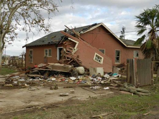
"We warned at the start of ZetaTalk, in 1995, thatunpredictable weather extremes, switching about from drought to deluge,would occur and increase on a lineal basis up until the pole shift. Where this occurred steadily, it has only recently become undeniable. ZetaTalk, and only ZetaTalk, warned of these weather changes, at that early date. Our early warnings spoke to the issue of global heating from the core outward, hardly Global Warming, a surface or atmospheric issue, but caused by consternation in the core. Affected by the approach of Planet X, which was by then starting to zoom rapidly toward the inner solar system for its periodic passage, the core was churning, melting the permafrost and glaciers and riling up volcanoes. When the passage did not occur as expected in 2003 because Planet X had stalled in the inner solar system, we explained the increasing weather irregularities in the context of the global wobble that had ensued - weather wobbles where the Earth is suddenly forced under air masses, churning them. This evolved by 2005 into a looping jet stream, loops breaking away and turning like a tornado to affect the air masses underneath. Meanwhile, on Planet Earth, droughts had become more intractable and deluges positively frightening, temperature swings bringing snow in summer in the tropics and searing heat in Artic regions, with the violence of storms increasing in number and ferocity."
The wobble seems to have changed, as the temperature in Europe suddenly plunged after being like an early Spring, Alaska has its coldest temps ever while the US and much of Canada is having an extremely mild winter. India went from fatal cold spell to balmy again. Has the Earth changed position vs a vs Planet X to cause this?[and from another]Bitter cold records broken in Alaska - all time coldest record nearly broken, but Murphy's Law intervenes[Jan 30]http://wattsupwiththat.com/2012/01/30/bitter-cold-records-broken-in-alaskaJim River, AK closed in on the all time record coldest temperature of -80°F set in 1971, which is not only the Alaska all-time record, but the record for the entire United States. Unfortunately, it seems the battery died in the weather station just at the critical moment. While the continental USA has a mild winter and has set a number of high temperature records in the last week and pundits ponder whether they will be blaming the dreaded "global warming" for those temperatures, Alaska and Canada have been suffering through some of the coldest temperatures on record during the last week.
There has been no change in the wobble pattern, the wobble has merely become more severe. Nancy noted a Figure 8 format when the Earth wobble first became noticeable, in early 2005, after Planet X moved into the inner solar system at the end of 2003. The Figure 8 shifted along to the east a bit on the globe between 2005 and 2009, (the last time Nancy took its measure) as Planet X came closer to the Earth, encountering the magnetic N Pole with a violent push earlier in the day. But the pattern of the Figure 8 remained essentially the same. So what changed recently that the weather patterns became noticeably different in late January, 2012?
The N Pole is pushed away when it comes over the horizon, when the noon Sun is centered over the Pacific. This regularly puts Alaska under colder air, with less sunlight, and thus the historically low temps there this January, 2012 as the wobble has gotten stronger. But by the time the Sun is positioned over India, the N Pole has swung during the Figure 8 so the globe tilts, and this tilt is visible in the weather maps from Asia. The tilt has forced the globe under the hot air closer to the Equator, warming the land along a discernable tilt demarcation line.
The next loop of the Figure 8 swings the globe so that the N Pole moves in the other direction, putting the globe again at a tilt but this time in the other direction. This tilt is discernable in weather maps of Europe, again along a diagonal line. Depending upon air pressure and temperature differences, the weather on either side of this diagonal line may be suddenly warm or suddenly cold. The tilt and diagonal line lingers to affect much of the US and Canada, but the Figure 8 changes at this point to be an up and down motion, pulling the geographic N Pole south so the US is experiencing a warmer than expected winter under a stronger Sun. Then the cycle repeats, with the magnetic N Pole of Earth pushed violently away again as the Sun is positioned over the Pacific.
Would the Zetas be able to let us know what is causing the early break-up of the Arctic Ice, the ice seems to have taken on a swirling pattern at the same time, would this be wobble related?[and from another]http://www.vancouversun.com/news/national/Canada+Arctic+cracks+spec... The ice in Canada’s western Arctic ripped open in a massive “fracturing event” this spring that spread like a wave across 1,000 kilometres of the Beaufort Sea. Huge leads of water – some more than 500 kilometres long and as much as 70 kilometres across – opened up from Alaska to Canada’s Arctic islands as the massive ice sheet cracked as it was pushed around by strong winds and currents. It took just seven days for the fractures to progress across the entire area from west to east.[and from another]http://earthobservatory.nasa.gov/IOTD/view.php?id=80752&src=iot... A high-pressure weather system was parked over the region, producing warmer temperatures and winds that flowed in a southwesterly direction. That fueled the Beaufort Gyre, a wind-driven ocean current that flows clockwise. The gyre was the key force pulling pieces of ice west past Point Barrow, the northern nub of Alaska that protrudes into the Beaufort Sea.
The Figure 8 formed by the N Pole during the daily Earth wobble has shifted somewhat to the East, due to Planet X positioned more to the right of the Earth during its approach. This was anticipated, and well described in ZetaTalk, the Earth crowding to the left in the cup to escape the approach of Planet X, so the angle between these two planets would change slightly. This shift of the Figure 8 to the East is due to the push against the Earth’s magnetic N Pole occurring sooner each day than prior. Thus instead of occurring when the Sun is high over the Pacific, over New Zealand, it is now occurring when the Sun is high over Alaska. All the wobble points have shifted eastward accordingly.
This has brought a lingering Winter to the western US, and a changed sloshing pattern to the Arctic waters. Instead of Pacific waters being pushed through the Bering Straits into the Arctic when the polar push occurs, the wobble is swinging the Arctic to the right, and then later to the left, creating a circular motion in the waters trapped in the Arctic. Since the Earth rotates counterclockwise, the motion also takes this path. This is yet another piece of evidence that the establishment is hard pressed to explain. They are attempting to ascribe this to high pressure and wind, all of which are not new to the Arctic, but this circular early breakup of ice in the Arctic is new.
The photo, taken on July 20, 2015, shows a view of buildings damaged by heavy flooding in Sijan Village in Iran’s Alborz Province.
At least eleven people have lost their lives in flash flooding across Iran including the capital Tehran.
Head of Relief and Rescue Organization of Iranian Red Crescent Society (IRCS), Naser Charkhsaz, said on Saturday the fatalities have occurred during the past 48 hours in the provinces of Tehran, Hormozgan in southern Iran, North Khorasan and East Azarbaijan in the country's north, IRIB reported.
Meanwhile, floods triggered by torrential rain killed five people in Pakdasht town in southeast Tehran on Friday, said Hadi Rahmati, the director general of crisis management for Tehran Province.
He added that rescue teams were immediately dispatched to the flood-hit areas and are conducting relief operations.
Spokesman for IRCS Mostafa Mortazavi also said that eight people, including five members of a family, were missing following heavy rain in eastern parts of Tehran Province.
Relief operations are underway in the flood-affected areas, he added.
A top official in Hormozgan also said the bodies of four members of a family were identified in the flooding in western parts of the province Friday night.
Earlier in late July, at least 11 people were killed in flash flooding and a summer storm in the provinces of Tehran and neighboring Alborz.
The incident happened when an unexpected summer storm and heavy rain struck the Iranian capital and its suburbs. Combined with heavy rain and lightning, the strong winds battered the northern, northwestern and western parts of the Iranian capital.
Comment by SongStar101 on September 16, 2015 at 9:19pm
Updates in CA as the fires are still ongoing.
California wildfires burn hundreds of homes, change lives
Property losses from a deadly Northern California wildfire, the most destructive this year in the western United States, climbed on Tuesday to at least 585 homes and hundreds of other structures that have gone up in flames.
Lake County sheriff's deputies began escorting some evacuees back to their properties to briefly tend to pets or livestock that were left behind.
But authorities said conditions in fire-ravaged areas remained unsafe, with downed power lines and other hazards. Residents whose homes remained intact would not be able to reoccupy their houses for at least another couple of days.
An estimated 13,000 residents remained displaced by evacuations, while the blaze, dubbed the Valley Fire, still posed a potential threat to some 9,000 buildings in the fire zone, roughly 50 miles (80 km) west of Sacramento, the state capital.
California Department of Forestry and Fire Protection spokesman Doug Pittman said Monday night that the fire's latest advance was mostly toward hillsides and mountains away from heavily populated areas. But the fire was reported especially active on Tuesday near the small mountain town of Loch Lomond and the Aetna Springs resort.
By Tuesday evening, the blaze had devoured more than 67,000 acres (27,0000 hectares)of timber, brush and grass left parched by four years of drought and weeks of extreme summer heat.
MAKING HEADWAY
As darkness fell across Northern California containment of the fire, a measure of how much of its perimeter has been enclosed within buffer lines carved through vegetation by ground crews, stood at 30 percent, up from 15 percent earlier in the day, Cal Fire said.
Water-dropping helicopters and airplane tankers grounded by thick smoke during the first days of the fire returned to the skies as visibility improved on Monday and Tuesday.
Temperatures have also cooled and winds have eased since the fire's peak on Saturday and early Sunday, when flames raced unchecked over 40,000 acres in just 12 hours.
The speed of the blaze caught area residents off-guard, forcing many to flee in chaotic evacuations through gauntlets of fire as surrounding houses and trees went up in flames.
Roughly half of Middletown, a town of about 1,500 residents, was left in ruin, with twisted, blackened debris strewn over charred foundations of buildings reduced to ash. A row of burned-out cars stood next to what remained of a flattened apartment house, and the charred hulks of more vehicles filled a lot where an auto mechanic shop once stood.
Four firefighters were hospitalized with burns they suffered in the early hours of the blaze. More than 2,300 personnel were on the fire lines as of Tuesday, Cal Fire said.
The 585 homes known destroyed represents the greatest property loss from a single wildfire among the scores of conflagrations that have raged across the drought-stricken U.S. West so far this year, according to the National Interagency Fire Center in Boise, Idaho.
Although the damage has yet to be quantified, the Valley Fire could become the largest insurance loss for a Northern California wildfire since a 1991 Oakland firestorm, said Mark Bove, a senior research meteorologist for New Jersey-based Munich Reinsurance America.
By comparison that calamity destroyed 3,200 buildings, with an industry-wide insured loss of about $3 billion, he said.
A separate blaze raging since Wednesday in the western Sierras near the former gold mining town of Jackson has destroyed 233 homes and 175 outbuildings, with some 10,000 people displaced by evacuations there, officials said. The so-called Butte Fire was 40 percent contained.
Comment by jorge namour on September 16, 2015 at 1:11pm
Swiss Alps in recent hours has happened a rare and frightening: a piece of the glacier of the Wetterhorn, at almost 3,700 meters above sea level, was split probably because of great heat and caused an enormous avalanche valley of Grindelwald in Switzerland, near the border with Piedmont. The images were collected by two escursionistii Swiss, Hans Buhler and his wife Marianne, who reported having "heard a roar: we thought in a plane, then we saw the white mass that swooped down. We shoot, then I got away. "
The event, according to the explanation given by glaciologists of Bern, has been caused by the particular shape of the glacier, in constant motion, he pushes his butt on a ledge from which then precipitate fragments . But this time the phenomenon has been enormous, as evidenced by the images.
Comment by lonne rey on September 16, 2015 at 12:21pm
16 Dead After Southern Utah Flash Floods; Four Still Missing
Flash flooding in southern Utah has killed at least 16 people since Monday night; four others remain missing.
Twelve of those deaths are in the small Utah border community of Hildale after a flash flood swept through the town.
Forty miles to the north, the Associated Press reports that four people were killed by flash flooding in Zion National Park and three remain missing.
The situation in Hildale has shocked the community. Flooding started overnight and "obviously caught these people off guard," Hildale assistant fire chief Kevin Barlow told The Associated Press. "Witnesses say they were backing out of it trying to get away from it and it still swept them in."
A height of three meters is the highest level of criticality for the country, but tonight the flood wave - according to official data of the hydrometer of Farini that henceforth no longer working and can not transmit data - is almost 15 meters (14.5) at 06:00 am. You could think of a calculation error, were it not for the pictures of entire buildings gutted even the upper floors with the obvious signs of the flood wave that has invaded the homes up to the third floor.
If Farini today had been inhabited as a century ago, we would be talking of a disaster with hundreds of victims. Fortunately there was no one in those houses. Here are the pictures:
Joso, Japan (CNN)Japan advised almost 3 million people to evacuate after heavy flooding killed seven people and left at least 15 missing in the eastern region of the country.
At least 27 people have been injured across 10 prefectures since floods inundated parts of eastern Japan after a tropical storm, the Fire and Disaster Management Agency said.
Rescue operations continued in the city of Joso, one of the worst-hit areas, although floodwaters are receding, it added.
A total of 2.8 million have been advised to evacuate, the agency said.
Comment by jorge namour on September 13, 2015 at 3:50pm
French Riviera: lightning, flood and storm-
Côte d'Azur - FRANCE
News - Published Sunday, September 13, 2015 by The Weather Channel- LA CHAINE METEO
Very strong thunderstorms broke out this morning in Provence French Riviera. Floods were reported. The winds exceeded 100 km / h. It's in the Nice region as the weather was most violent.
The Var and Alpes-Maritimes have been a deluge in the early morning. As expected, violent storms erupted on these two departments placed special release by us. These storms are linked to violent air mass conflict between the hot air rising from the Mediterranean and the Atlantic cooler air. The violence of the current weather is increased by water still warm sea (abnormality of + 3 ° C).
One month and a half of rain in four hours
Between Le Luc en Provence, Fréjus, Cannes and Nice, torrential rain fell in a short period of time. He fell from 90 to 135mm of water between 5 and 9:00 this morning, the equivalent of a month and a half of rain in the space of just four hours.
Stormy winds
The passage of storms, the wind is unleashed. It is located in Sospel on the heights of Menton, the wind blew stronger with a flurry 117 km / h. A Nice Rimiez, a gust to 112 km / h was measured. In Menton, the strongest gust reached 98 km / h.
Very intense electrical activity, some flooding
Under these storms, electrical activity was very intense, with a flash every 2 to 3 seconds in the Nice region. According Keraunos the French Observatory of tornadoes and severe thunderstorms, more than 25,000 lightning strikes were recorded in the PACA region between 2:30 ET 8:30 on Sunday, after the lightning 110,000 already recorded yesterday in France. Significant runoff are reported and some flooding in the Var and Alpes-Maritimes. The floor of the A8 is flooded in places. Nice Nord exit was even temporarily closed. On the secondary network, many runoff are observed.
California Wildfire Explodes to Nearly 15,000 Acres, Evacuations Ordered
California wildfire expands to nearly 15,000 acres0:20
Driven by high winds and soaring temperatures, a wildfire in California more than tripled in size Thursday, swelling to more than 14,000 acres, fire officials said.
The so-called Butte Fire, located east of the town of Jackson southeast of Sacramento, was a little more than 100 acres shortly after it broke out at around 2:26 p.m. Wednesday, and grew to around 4,000 acres by Thursday.
The Butte Fire burns in wooded areas east of Jackson, California. The fire swelled from 4,000 acres to more than 14,000 acres Thursday. NBC News
Over the day, and as temperatures soared, the fire grew to 14,700 acres, the California Department of Forestry and Fire Protection, also known as Cal Fire, said.
The fire had been 20 percent contained earlier Thursday, but by the evening it was only 10 percent contained, Cal Fire said.
The fire was "extremely active" Thursday, making substantial runs up a canyon and fueled by hot winds and high temperatures, a Cal Fire spokesman said.
At least six homes have been destroyed. There were mandatory evacuation orders for part of a subdivision and part of the town of Pine Grove, the department said. It was not immediately clear how many people were ordered to leave their homes.
A reporter for KCRA captured dramatic video of the fire as they drove near the blaze after it jumped a road and scorched a hillside Thursday, sending clouds of ash and smoke over the highway.
Comment by lonne rey on September 10, 2015 at 11:28am
170,000 flee homes after floods hit Japan, Fukushima nuclear plant safety at risk
Tens of thousands of people have been ordered to leave homes across Japan after Tropical Typhoon Etau ripped through the country. Military helicopters plucked residents from the roofs of their homes.
Lashing rain pounded the country for a second day, and the Kinugawa River has burst through a flood barrier, sending a tsunami-like wall of water into Joso, about 50 kilometers northeast of Tokyo, AP reported.
Comment by Gerard Zwaan on September 10, 2015 at 11:28am
Grave danger imminent! Nearly 200,000 asked to evacuate as Japan is sandwiched between a hurricane and a typhoon
Authorities in central Japan Thursday (Sep 9) ordered tens of thousands to flee their homes after torrential rains flooded rivers and triggered landslides, with one person missing after a mudslide buried houses.
The Japan Meteorological Agency issued special downpour warnings for Tochigi and Ibaraki prefectures, north of Tokyo, urging vigilance against mudslides and flooding.
"This is a scale of downpour that we have not experienced before.
Grave danger could be imminent," meteorologist Takuya Deshimaru said at an emergency press conference.
Parts of central Tochigi have been deluged with almost 60cm of rain since Monday evening. Authorities in Tochigi ordered more than 90,000 residents to evacuate, while another 80,000 were advised to leave their homes, public broadcaster NHK said.
The meteorological observatory in Tochigi said the Kinugawa river, which also runs through Ibaraki, overflowed early Thursday. In Tochigi's Kanuma city, a local official said rescuers were searching for a missing person believed to be buried in mudslides.
"We don't know details of the person yet," he said. NHK reported it was a woman in her 60s buried after mudslides destroyed houses.
Her husband was rescued soon after, it said.
The Japan Meteorological Agency issued a heavy rain emergency warning to Tochigi and Ibaraki prefectures on Thursday due to extremely high risks of sediment disasters in the Kanto region.
The emergency warning for heavy rain was issued to Tochigi Prefecture at 12:20 a.m. and to Ibaraki Prefecture at 7:45 a.m. Typhoon No. 18 changed to an extratropical cyclone, triggering torrential rain that brought 405.5 millimeters of rainfall in Nikko, Tochigi Prefecture, and 325.5 millimeters in Kanuma in the prefecture during a 24-hour period until midnight Wednesday.
Evacuation directives were issued to more than 2,600 people in Tochigi, Sakura and other cities in Tochigi Prefecture late Wednesday as water levels rose in rivers with an increased risk of landslides.
You need to be a member of Earth Changes and the Pole Shift to add comments!
Join Earth Changes and the Pole Shift