Weather:

Weather Wobble

Jet Stream tornados

Siberian Freeze Weather Wobble

Wild weather , [2]

Wobble Clouds

Hurricane development

Violent Push

Weather & ocean currents

Europe Weather

Tides and Whirlpools:

Storm Clash whirlpools

Lurch of earth

Tides , [2]

Whirlpools

Wobble Sloshing


"We warned at the start of ZetaTalk, in 1995, that unpredictable weather extremes, switching about from drought to deluge, would occur and increase on a lineal basis up until the pole shift. Where this occurred steadily, it has only recently become undeniable. ZetaTalk, and only ZetaTalk, warned of these weather changes, at that early date. Our early warnings spoke to the issue of global heating from the core outward, hardly Global Warming, a surface or atmospheric issue, but caused by consternation in the core. Affected by the approach of Planet X, which was by then starting to zoom rapidly toward the inner solar system for its periodic passage, the core was churning, melting the permafrost and glaciers and riling up volcanoes. When the passage did not occur as expected in 2003 because Planet X had stalled in the inner solar system, we explained the increasing weather irregularities in the context of the global wobble that had ensued - weather wobbles where the Earth is suddenly forced under air masses, churning them. This evolved by 2005 into a looping jet stream, loops breaking away and turning like a tornado to affect the air masses underneath. Meanwhile, on Planet Earth, droughts had become more intractable and deluges positively frightening, temperature swings bringing snow in summer in the tropics and searing heat in Artic regions, with the violence of storms increasing in number and ferocity."

ZETATALK


From the ZetaTalk Chat Q&A for February 4, 2012:


The wobble seems to have changed, as the temperature in Europe suddenly plunged after being like an early Spring, Alaska has its coldest temps ever while the US and much of Canada is having an extremely mild winter. India went from fatal cold spell to balmy again. Has the Earth changed position vs a vs Planet X to cause this? [and from another] Bitter cold records broken in Alaska - all time coldest record nearly broken, but Murphy's Law intervenes [Jan 30] http://wattsupwiththat.com/2012/01/30/bitter-cold-records-broken-in-alaska Jim River, AK closed in on the all time record coldest temperature of -80°F set in 1971, which is not only the Alaska all-time record, but the record for the entire United States. Unfortunately, it seems the battery died in the weather station just at the critical moment. While the continental USA has a mild winter and has set a number of high temperature records in the last week and pundits ponder whether they will be blaming the dreaded "global warming" for those temperatures, Alaska and Canada have been suffering through some of the coldest temperatures on record during the last week.

There has been no change in the wobble pattern, the wobble has merely become more severe. Nancy noted a Figure 8 format when the Earth wobble first became noticeable, in early 2005, after Planet X moved into the inner solar system at the end of 2003. The Figure 8 shifted along to the east a bit on the globe between 2005 and 2009, (the last time Nancy took its measure) as Planet X came closer to the Earth, encountering the magnetic N Pole with a violent push earlier in the day. But the pattern of the Figure 8 remained essentially the same. So what changed recently that the weather patterns became noticeably different in late January, 2012?

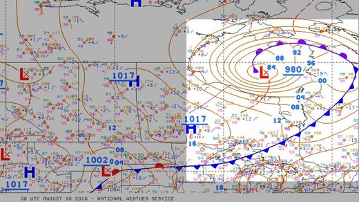
The N Pole is pushed away when it comes over the horizon, when the noon Sun is centered over the Pacific. This regularly puts Alaska under colder air, with less sunlight, and thus the historically low temps there this January, 2012 as the wobble has gotten stronger. But by the time the Sun is positioned over India, the N Pole has swung during the Figure 8 so the globe tilts, and this tilt is visible in the weather maps from Asia. The tilt has forced the globe under the hot air closer to the Equator, warming the land along a discernable tilt demarcation line.

The next loop of the Figure 8 swings the globe so that the N Pole moves in the other direction, putting the globe again at a tilt but this time in the other direction. This tilt is discernable in weather maps of Europe, again along a diagonal line. Depending upon air pressure and temperature differences, the weather on either side of this diagonal line may be suddenly warm or suddenly cold. The tilt and diagonal line lingers to affect much of the US and Canada, but the Figure 8 changes at this point to be an up and down motion, pulling the geographic N Pole south so the US is experiencing a warmer than expected winter under a stronger Sun. Then the cycle repeats, with the magnetic N Pole of Earth pushed violently away again as the Sun is positioned over the Pacific.


From the ZetaTalk Chat Q&A for April 6, 2013:


Would the Zetas be able to let us know what is causing the early break-up of the Arctic Ice, the ice seems to have taken on a swirling pattern at the same time, would this be wobble related? [and from another] http://www.vancouversun.com/news/national/Canada+Arctic+cracks+spec... The ice in Canada’s western Arctic ripped open in a massive “fracturing event” this spring that spread like a wave across 1,000 kilometres of the Beaufort Sea. Huge leads of water – some more than 500 kilometres long and as much as 70 kilometres across – opened up from Alaska to Canada’s Arctic islands as the massive ice sheet cracked as it was pushed around by strong winds and currents. It took just seven days for the fractures to progress across the entire area from west to east. [and from another] http://earthobservatory.nasa.gov/IOTD/view.php?id=80752&src=iot... A high-pressure weather system was parked over the region, producing warmer temperatures and winds that flowed in a southwesterly direction. That fueled the Beaufort Gyre, a wind-driven ocean current that flows clockwise. The gyre was the key force pulling pieces of ice west past Point Barrow, the northern nub of Alaska that protrudes into the Beaufort Sea.


The Figure 8 formed by the N Pole during the daily Earth wobble has shifted somewhat to the East, due to Planet X positioned more to the right of the Earth during its approach. This was anticipated, and well described in ZetaTalk, the Earth crowding to the left in the cup to escape the approach of Planet X, so the angle between these two planets would change slightly. This shift of the Figure 8 to the East is due to the push against the Earth’s magnetic N Pole occurring sooner each day than prior. Thus instead of occurring when the Sun is high over the Pacific, over New Zealand, it is now occurring when the Sun is high over Alaska. All the wobble points have shifted eastward accordingly.

This has brought a lingering Winter to the western US, and a changed sloshing pattern to the Arctic waters. Instead of Pacific waters being pushed through the Bering Straits into the Arctic when the polar push occurs, the wobble is swinging the Arctic to the right, and then later to the left, creating a circular motion in the waters trapped in the Arctic. Since the Earth rotates counterclockwise, the motion also takes this path. This is yet another piece of evidence that the establishment is hard pressed to explain. They are attempting to ascribe this to high pressure and wind, all of which are not new to the Arctic, but this circular early breakup of ice in the Arctic is new.

Views: 629718

Comment

You need to be a member of Earth Changes and the Pole Shift to add comments!

Join Earth Changes and the Pole Shift

Comment by SongStar101 on May 26, 2016 at 7:32am

Mercury rising: India records its highest temperature ever

http://www.cnn.com/2016/05/20/asia/india-record-temperature/

(CNN)India recorded its highest-ever temperature on Thursday when the heat in the town of Phalodi, in the western state of Rajasthan, shot up to a burning 51 degrees Celsius (123.8 degrees Fahrenheit). 

It was the second day in a row the town experienced temperatures in excess of 50 degrees Celsius.
Other towns in the state, such as Churu, also recorded highs of about 50 degrees Celsius (122 degrees Fahrenheit) the same day.
In New Delhi, the capital, the temperature reached nearly 47 degrees Celsius on Wednesday.
The previous temperature record in India was held by Alwar, also in Rajasthan, at 50.6 degrees Celsius (123.1 Fahrenheit) in 1956. According to the Guinness Book of World Records, the highest temperature ever was recorded at 56.7 degrees Celsius (134 degrees Fahrenheit) in Death Valley, California, on July 10, 1913.
Rajasthan, home to the Thar desert, typically records the highest temperatures in India. Temperatures can soar as a result of incoming western winds from hot areas.

Red alert issued

The IMD has issued a red-level alert for Rajasthan as well as for other states like Madhya Pradesh and Gujarat, where temperatures, despite not having crossed the 50-degree mark, are higher than average.
India has recorded higher than normal temperatures throughout 2016.
Many areas are experiencing severe heat waves and state governments estimate more than 370 people killed so far.
ndia recorded its highest ever temperature on Thursday, in Phalodi, Rajasthan, where numbers shot up to a burning 51 degrees Celsius (123.8 degrees Fahrenheit)
This comes on the back of a searing 2015, when more than 2,500 died in the summer. 2015's high casualty rate has led to India's National Disaster Management Authority coordinating with states on heat wave action plans to spread awareness and establish preventative measures.

Double whammy of heat wave and drought

Heatwave hits India amid worst drought in decades 02:03
The heat wave has also coincided with another major environmental problem: drought.
After two successive below-average monsoons in 2014 and 2015, ground water levels have receded, impacting many rural Indians who rely on ground wells for drinking water.
The western Indian state of Maharashtra is one of the worst impacted, with the state government organizing emergency 'water trains' to bring daily supplies to villages.
The double whammy of heat and drought has led to accidents and fatalities.
On Monday, five men died in the northern state of Haryana when they attempted to restore a well that had fallen into disuse.
Authorities say the men were killed when they inhaled poisonous gas trapped in the well.
India's meteorological department says the heat wave will continue into next week. Many schools across the country have been operating on shortened days.
The monsoons are expected to hit India in June, bringing much-needed rain and relief. The 2016 monsoons are forecast to bring an above-average amount of rainfall.
Unrelated to the annual monsoons, large parts of Sri Lanka and now southern India have been lashed this week by rains caused by a tropical depression in the Bay of Bengal.

Caught on camera: A dangerous, melting road in Gujarat

Comment by KM on May 24, 2016 at 3:38pm

http://strangesounds.org/2016/05/rare-tornado-damages-minden-german...

Rare tornado damages Minden, Germany

A rare tornado swept across Minden on May 22, 2016 at 7:30pm local time.

The extreme thunderstorm went down on the Minden-Lübbecke with heavy rain, high winds and hail.  The strong thunderstorm particularly hit the towns of Minden, Porta Westfalica, Bad Oeynhausen and Peter Hagen hard.  Of these, a total of 33 persons were affected no one was injured.

tornado minden, tornado minden germany, tornado minden deutschland, tornado minden photo, tornado minden video, tornado minden may 22 2016

tornado minden, tornado minden germany, tornado minden deutschland, tornado minden photo, tornado minden video, tornado minden may 22 2016

The district Minden-Meissen was hit by a tornado on May 22, 2016.

tornado minden, tornado minden germany, tornado minden deutschland, tornado minden photo, tornado minden video, tornado minden may 22 2016

tornado minden, tornado minden germany, tornado minden deutschland, tornado minden photo, tornado minden video, tornado minden may 22 2016

The strong thunderstorm particularly hit the towns of Minden, Porta Westfalica, Bad Oeynhausen and Peter Hagen hard.


Comment by KM on May 24, 2016 at 3:35pm

http://strangesounds.org/2016/05/giant-hot-geyser-erupts-barnaul-br...

Giant hot geyser erupts in Barnaul, breaks windows on ninth floor of building

This giant hot geyser started erupting in Barnaul, Russia on May 20, 2016.

It crashed windows at the ninth floor of a building and flooded apartments. Amazing!

Comment by KM on May 23, 2016 at 2:21pm

http://strangesounds.org/2016/05/flowers-cover-the-desert-in-saudi-...

After heavy rains and extreme weather in the south-western Saudi Arabian province, ‘Asir…

Flowers and grass cover the desertic ground around Bisha, Saudi Arabia.

flower desert saudi arabia, flowering desert saudi arabia, flower desert saudi arabia may 2016, flower desert saudi arabia pictures

flower desert saudi arabia, flowering desert saudi arabia, flower desert saudi arabia may 2016, flower desert saudi arabia pictures

flower desert saudi arabia, flowering desert saudi arabia, flower desert saudi arabia may 2016, flower desert saudi arabia pictures

From sand to prairies! Awesome flowering desert phenomenon!

Comment by Derrick Johnson on May 21, 2016 at 5:45am

Spring Has Sprung In The Arctic ... But It’s Way Too Early For It

NOAA just reported the earliest snowmelt in 78 years of recorded history.


NOAA

One of the coldest places on Earth is already starting to see signs of spring — a good month or two before it should, according to researchers.

The National Oceanic and Atmospheric Administration announced Friday that Barrow Observatory, located 320 miles north of the Arctic Circle, just reported the earliest snowmelt in 78 years of recorded history.

It looks like late June or early July right now,” David Douglas, a research biologist with the U.S. Geological Survey, said in a statement.

The remote Alaska observatory is usually one of the last places in the United States to see its snow begin to vanish. This year, however, the snowmelt began May 13, a full 10 days earlier than the previous record set in 2002.

Welcome to the terrifying realities of global climate change.

(The animation above from the National Snow and Ice Data Center shows the fracturing and rotation of sea ice near Alaska from April 1-24.)

The worrisome snow melt comes on the heels of a record-warm Alaska winter, which saw temperatures average more than 11 degrees above normal, according to NOAA. The agency also recently announced that April 2016 was the 12th consecutive month to set a global temperature record.

Douglas said the melt in Alaska illustrates how fragile and dynamic the Arctic’s ice coverage has become. In addition to an early snowmelt, he and other scientists are expecting 2016 to see a record low for sea ice in the Arctic

“Polar bears are having to make their decisions about how to move and where to go on thinner ice pack that’s mostly first-year ice,” Douglas said.

And the repercussions don’t stop there.

George Divoky, a wildlife biologist who heads the Friends of Cooper Island research institute, said he expects the early melt-off will have drastic effects on Alaska wildlife, including Arctic bird species. 

“It’s like a train wreck you can’t look away from,” Divoky said in a statement. “You never know what you’re going to see and this year’s as big a mystery as any.”

Source: http://www.huffingtonpost.com/entry/arctic-snowmelt-2016_us_573f6fa...  

Comment by KM on May 18, 2016 at 2:18pm

http://floodlist.com/asia/sri-lanka-floods-landslides-may-2016

Sri Lanka – Deadly Floods and Landslides After 355mm of Rain in 24 Hours

An area of low pressure above Sri Lanka has caused heavy rainfall across the country since 14 May 2016. Some locations saw over 350 mm (13.77 inches) of rain fall in 24 hours. Floods and landslides have caused havoc in as many as 19 districts of the country, including around Colombo. Sri Lanka’s Department of Meteorology say in a 24 hour period 15 to 16 May, Colombo recorded 256 mm of rain. According to WMO figures, the mean total rainfall for Colombo in April is 245.6 mm

Strong winds, lightning and falling trees have also caused major damage.

Sri Lanka’s Disaster Management Centre (DMC) report said that since 13 May, over 200,000 people have been affected, with 134,000 currently displaced and staying in 176 relief camps set up for the victims. Almost 1,300 homes have been damaged and 68 destroyed.

DMC said in a report yesterday that at least 8 people have died in the severe weather since 13 May, with at least 9 more still missing. One person died in floods in Wattala, Gampaha, Western Province. Four of the deaths occurred after a landslide in Dehiovita, Kegalle, Sabaragamuwa Province.

The other three victims died in separate incidents; one as a result of a fallen tree, another after lightning strike, and the third as a result of electrocution from fallen power cables.

DMC officials added that 2 people are missing after a landslide in Imbulpe, Ratnapura, also in Sabaragamuwa Province.

The Sri Lanka Army say that they are carrying out search and rescue operations in Ilukwaththa, Ranmalaka, Pilimathalawa, Kandy District, where a landslide destroyed two houses, burying six people, late on 16 May 2016.

Flood Defences

Teams from Sri Lanka navy have been drafted in to help shore up flood defences, including around the country’s Parliament Complex, which was threatened by floods from the rising levels of Diyawanna Lake.

Further naval personnel were deployed for flood relief duties in Thalduwa, Rajagiriya, Wellampitiya, Malwana and Kegalle areas.

Rainfall and Forecast

Sri Lanka’s Department of Meteorology say that, during a 24 hour period between 15 and 16 May, Deraniyagala recorded 355.5 mm of rain, Colombo 256 mm, Katunayake 262mm, Ratmalana 190mm, Mannar 185.5 mm and Trincomalee 182.4 mm.

Sri Lanka’s Department of Meteorology said earlier today the situation I likely to improve over the next 24 hours, although some further rainfall is expected. In a statement today, they said:

“The low pressure area has moved away from the island and rainy conditions will gradually reduce during next few days as the system is further moving away from the island. However, strong windy conditions, particularly in the sea areas around the island will continue further.

“Showers or thunder showers will occur at times in the Northern, North-central, North-Western, Western, Central and Sabaragamuwa provinces and in the Galle and Matara districts.

“Heavy falls (more than 100 mm) are likely at some places.
Showers or thunder showers will occur at several places elsewhere.

“There may be temporary localized strong winds during thundershowers. General public is kindly requested to take adequate precautions to minimize damages caused by lightning activity”.


Comment by KM on May 17, 2016 at 2:33pm

http://www.dailymail.co.uk/news/article-3594046/What-happened-Sprin...

Brrrrrr-ing back Spring! New England is covered in a record-breaking SEVEN inches of snow turning it back into a winter-wonderland in mid May

  • Town of Perham in Maine saw 7.5 inches of wintry dusting on Monday 
  • At the same time, 4.5 inches was recorded in the Maine town of Caribou
  • The readings set a new record for snow this late in May
  • All the while Fairbanks in Alaska was warmer than cities such as Boston, Cleveland and Denver have been so far this year 
  • Mercury also dropped 15 degrees lower than normal across the north east
  • Was caused by a surprising arctic blast that swooped in late last week  

It's only one month until the official start of summer.

The sun should be coming out and homeowners are already thinking about dusting off the grills. 

But snow is still falling at a record-breaking rate in parts of the United States while others are still experiencing unseasonably brisk conditions.

The National Weather Service says the town of Perham in Maine saw 7.5 inches on Monday as temperatures plummeted 15 degrees below normal in cities across the north east.

The mercury dropped into the 30s following a surprising blast of arctic air.

Scroll down for video 

New England has seen record-breaking levels of storm over the weekend for this late in May. There was 4.5 inches in the northern Maine town of Caribou (pictured)

New England has seen record-breaking levels of storm over the weekend for this late in May. There was 4.5 inches in the northern Maine town of Caribou (pictured)

Caribou (pictured) got a thick layer of snow while the northern Maine town of Perham got 7.5 inches 

Caribou (pictured) got a thick layer of snow while the northern Maine town of Perham got 7.5 inches 

At the same time, 4.5 inches was recorded in the northern Maine town of Caribou.

The wintry dustings set a record for the most snow this late in May.

Six inches of snow also fell in Caswell and New Sweden, Maine, according to CBS News.

In northern New Hampshire, Pittsburg recorded 2.5 inches. The Vermont towns of Middlesex and Hyde Park and near Pomfret got 2 inches Monday morning.

The snow, however, is not expected to be around for long. 

According to multiple forecasts, temperatures are set to rise, with rain in northern New Hampshire and Maine.

According to Weather.com, the Alaskan city of Fairbanks recorded a top of 82 degrees on Saturday.

Was warmer warmer than cities cities such as Boston, Cleveland and Denver have seen so far in 2016.


Comment by KM on May 12, 2016 at 2:39pm

http://www.koco.com/weather/rare-backwards-tornado-discovered-durin...

Rare, backwards tornado discovered during Monday's outbreak

A closer look at the anticyclonic tornado track


  • Sulphur, Oklahoma tornado radar image from Monday, May 9, 2016.


OKLAHOMA CITY —Most tornadoes spin counter-clockwise, but during Monday's tornado outbreak, one tornado was spinning clockwise or backwards.


Anticyclonic tornadoes are very, very rare, but a tornado near Roff, Oklahoma, was on the ground for almost 13 miles.

An anticyclonic twister developed about 6 miles north-northwest of Sulphur and moved northeast. The tornado has been rated as an EF1 tornado with winds up to 110 mph.

The tornado was likely wrapped in precipitation and not very visible. At the same time, a larger EF-3 tornado was on the ground, moving to the east, about 6 miles to the west of the anticyclonic tornado. One could even consider this rare tornado as it satellite tornado to moved around the larger tornadic circulation.

Click on the related content to see what both tornadoes looked like with Doppler radar imagery


Comment by Howard on May 11, 2016 at 3:27am

Dramatic Footage of Gigantic Tornado in Colorado (May 7)

A series of tornadoes swept across eastern Colorado this weekend followed by severe weather impacting the Plains states.  

One twister touched down north of Wray in Yuma County on Saturday evening, leaving at least five people with injuries and causing damage to buildings and other structures. 

The tornado was rated an EF2 by the National Weather Service (NWS) after the damage was surveyed on Sunday.

The tornado caused damage from County Road 37 to County Road 42 near Highway 385.

The storm also produced baseball-sized hail in some parts of Colorado.

At least five tornadoes hit Yuma County, according to the NWS.

Source

http://www.theweathernetwork.com/us/news/articles/us-weather/extrem...

Comment by KM on May 10, 2016 at 2:00pm

http://floodlist.com/africa/rwanda-floods-landslides-gakenke-muhanga

Rwanda – At Least 49 Killed in Floods and Landslides, 500 Homes Destroyed

Landslides and floods hit several parts of Rwanda between 07 and 08 May 2016 after a period of heavy rainfall. Government officials say that at least 49 deaths have been recorded so far. Some of the victims drowned in flood water, others died after houses collapsed under the heavy rain or landslide.

The worst hit areas are the districts of Gakenke and Muhanga. As many as 34 people have died in Gakenke, 8 in Muhanga, 4 in Rubavu and 3 in Ngororero. Around 26 injuries have also been reported.

Reports from the Ministry for Disaster Management and Refugee Affairs say that over 500 houses have been completely destroyed, leaving thousands homeless.

The disaster comes just days before the country hosts the World Economic Forum on Africa, which will be held in Kigali from 11 to 13 May 2016.

Floods in Gakenke, Rwanda. Photo: Government of RwandaFloods in Gakenke, Rwanda. Photo: Government of Rwanda

Roads, Power and Water Supplies Damaged

The floods and landslides have also caused damage to roads and transport infrastructure. Some roads have been completely blocked and officials say that the Kigali-Muhanga and Kigali-Musanze roads are closed in order to prevent risks for commuters.

Electricity supply has also been interrupted after power cables in Gakenke were downed during the heavy rain.

Supply of drinking water has also been cut. Water and Sanitation Corporation Limited (WASAC Ltd) say that it has temporally suspended water treatment at the Nzove treatment plants due to heavy rain which has caused “high water turbidity.” The company said that “There will be water supply interruptions in some areas of Kigali, Kacyiru, Remera and Kicukiro.”

Government Reaction

The Rwandan government has expressed its solidarity with families affected by the disasters, and Prime Minister Anastase Murekezi has assured families affected by the disasters of the government’s support.

In a statement issued earlier today, the government said:

 the disasters of the government's support. 

SEARCH PS Ning or Zetatalk

 
Search:

This free script provided by
JavaScript Kit

Donate

Donate to support Pole Shift ning costs. Thank you!

© 2025   Created by 0nin2migqvl32.   Powered by

Badges  |  Report an Issue  |  Terms of Service