Volcano watch
Benevolent extraterrestrials monitoring volcanoes to provide early warning to human partners.
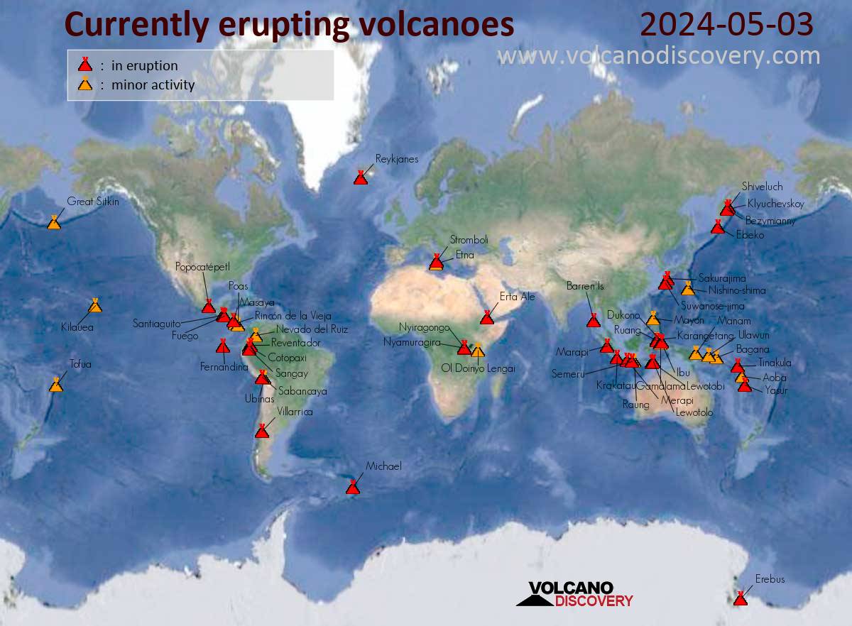
Volcanic activity worldwide 18 October, 2025: Kilauea in Hawaii, Santiaguito volcano, Fuego, Semeru, Ibu, Dukono, Reventador, and soon "all volcanoes that have been active within the memory of man will begin spewing and burping and oozing, and many that were not expected to become active will reactive."
"Of course, all volcanoes will explode, as this is going to be a very severe pole shift. What about the months and years preceding the pole shift? It is no secret that Mammoth Lake and the caldera of Yellowstone are warming up, and the populace has been prepared for these occurrences by the movie Volcano where there, in the middle of LA, lava is bubbling up. In fact, there is a fault line running from the approximate San Diego/LA area, up into the Sierras, and this is liable to rupture rather violently during one of the quakes that precedes the pole shift by some months. Volcanic eruptions from that area in the Sierras can be expected. Will Mount St. Helen erupt? All volcanoes that have been active within the memory of man will begin spewing and burping and oozing, and many that were not expected to become active will reactive." ZetaTalk - Feb 15, 2000
Views: 222453
Comment
-
Comment by Howard on May 3, 2016 at 4:01am
-
Two Costa Rican Volcanoes Erupting (May 1)
Two Costa Rican volcanoes, Turrialba in Cartago province and Rincón de la Vieja in Guanacaste began erupting over the weekend.
An explosion of ash and rocks was recorded at Turrialba Volcano at 3 a.m. on Saturday. The dark column of ash was visible next to the white column of vapor and gases that has been rising from the crater over the past few weeks.
Once again, access to Turrialba volcano and national park has been closed off due to the near-continuous ash emissions.
Small explosions have also continued. Between Friday morning and the early hours of Monday, RSN recorded more than 200 explosions, many of them hurling ash and rock out of the crater.
One of these explosions, at around 6 a.m. Monday, reached two kilometers high, RSN reported.
A five kilometre (3.1 mile) perimeter around the volcano has been established, the Comisión Nacional de Emergencias (CNE) – national emergency commission – said Sunday.
“Due to the constant activity at the Turrialba volcano and the arrival of tourists and the curious, authorities,” have decided to restrict access, said the CNE statement.
The Red Sismológica Nacional(RSN) – National Seismology Network – registered at least six eruptions on Sunday morning that released gas and ash into the atmosphere.
On Monday afternoon, the National Emergency Commission (CNE) called on the population to remain calm. CNE President Iván Brenes said the increase in the volcano’s activity has caused classes to be suspended at five public schools in Turrialba.
He said officials are monitoring crops for the presence of ash, and checking for possible harm to animals on the numerous dairy farms in the northern part of Turrialba canton.
A prolonged release of ash along with a high level of seismic activity was registered almost all day on Saturday, the RSN said.
Area residents are being asked to remain outside the restricted area around the volcano, which is located within the Turrialba national park, located some 70 kilometres (40 miles) east of San Jose.
Turrialba has entered its most active eruption phase since October 2014. On March 2015, the ash spewed from the volcano reached the greater metropolitan area of San Jose, forcing the temporary closure of the international airport on three separate occasions.
At the northern end of the country, in Guanacaste province, OVSICORI reported a moderate explosion at Rincón de la Vieja Volcano on Sunday at 2:37 p.m.
OVSICORI instruments also recorded an increase in seismic activity for some 11 minutes following the explosion.
Sources
http://qcostarica.com/turrialba-volcano-continues-with-ash-eruptions/
http://www.laht.com/article.asp?ArticleId=2411194&CategoryId=23558
http://www.ticotimes.net/2016/05/03/costa-rica-turrialba-volcano-ri...
-
Comment by jorge namour on May 1, 2016 at 5:06pm
-
Minor eruption forms new crater on White Island - NEW ZEALAND
30 APRIL 2016
http://www.nzherald.co.nz/nz/news/article.cfm?c_id=1&objectid=1...
The White Island crater from the volcano camera situated at the abandoned sulphur works.
A new crater has formed on White Island following a minor eruption on Wednesday but it's likely little or no magma was ejected.
During an aerial inspection of the site on Whakaari, volcanologists found the new crater in the northeast corner of the complex and found evidence of a landslide. Hot translucent gas was being emitted from the new vent but GeoNet said gas levels were only slightly elevated.
Seismic activity remains low and the Volcanic Alert Level remains at Level 2.
At about 9.50pm on Wednesday, the volcanic island in the Bay of Plenty erupted, covering at least 80 per cent of the floor of the main crater and up two sides of the crater wall with a dark-green ash.
------------------------------
First White Island rumbles, now Mt Ruapehu is making volcanologists sit up - NEW ZEALAND NZ HERALDhttp://www.nzherald.co.nz/nz/news/article.cfm?c_id=1&objectid=1...
29 APRIL 2016. First it was White Island's crater lake that was making scientists sit up - and now it is the one atop Mt Ruapehu. But the timing of White Island's latest bout of unrest, which culminated in an overnight eruption this week, and a volcanic earthquake swarm 241km away beneath Mt Ruapehu's crater lake should be seen only as a coincidence, a volcanologist says.
This afternoon, GNS Science reported that the mountain's crater lake had risen from 25C in mid-April to 40C.
The lake temperature had been rising since late 2015, at a similar rate to that observed in March 2011, April 2014 and February 2015. And over the past few days, scientists had been recording an earthquake swarm beneath the lake - something that has been an uncommon occurrence there over recent years.
IMAGE: The temperature of the crater lake at the top of Mt Ruapehu has risen in temperature. Photo / Getty Images
-
Comment by SongStar101 on April 21, 2016 at 8:57pm
-
Wow! There are nearly 40 volcano's erupting currently with more on eruption activity alert warnings! The South American peninsula is red and active with big quakes!
http://earthquakes.volcanodiscovery.com/
http://www.volcanodiscovery.com/volcano-activity/news/57322/Volcani...
Currently erupting:
Alaid (Northern Kuriles): intense thermal signal from summit crater, strong degassing (updated 20 Apr 2016)
Ambrym (Vanuatu): active lava lakes in several craters (updated 18 Feb 2016)
Aso (central Kyushu, Japan): degassing, sporadic steam / ash explosions (updated 8 Mar 2016)
Batu Tara (Sunda Islands, Indonesia): strombolian explosions, ash plumes up to 500 m, extrusion of a small lava dome with rockfalls (updated 28 Nov 2015)
Chikurachki (Paramushir Island): new eruption since end of March 2016 (updated 31 Mar 2016)
Colima (Western Mexico): sporadic small explosions (updated 31 Mar 2016)
Copahue (Chile/Argentina): seismic unrest, occasional ash venting (updated 22 Mar 2016)
Dukono (Halmahera): mild strombolian activity, continuous intense ash emissions (updated 20 Apr 2016)
Erebus (Antarctica): active lava lake in summit crater (updated 8 Dec 2014)
Erta Ale (Danakil depression, Ethiopia): overflowing lava lake (updated 2 Mar 2016)
Fuego (Guatemala): lava flows on S and W flanks, lava fountaining from summit vent (updated 13 Apr 2016)
Ibu (Halmahera, Indonesia): stromolian and phreatomagmatic explosions (updated 29 Oct 2015)
Karymsky (Kamchatka): occasional small explosions, thermal anomaly (updated 1 Mar 2016)
Kerinci (Sumatra): intermittent ash emissions (updated 14 Apr 2016)
Kilauea (Hawai'i): new lava flow from vents on NE flank of Pu'u 'O'o (updated 28 Apr 2015)
Kliuchevskoi (Kamchatka): mild strombolian activity in summit crater (updated 20 Apr 2016)
Masaya (Nicaragua): active lava lake in summit crater since mid Dec 2015 (updated 3 Apr 2016)
Momotombo (Nicaragua): intermittent vulcanian explosions (updated 29 Mar 2016)
Nevado del Ruiz (Colombia): intermittent explosions, steaming, ash venting (updated 31 Mar 2016)
Nyiragongo (DRCongo): new vent on crater floor (updated 8 Mar 2016)
Ol Doinyo Lengai (Tanzania): effusion of natrocarbonatite lava inside the crater (updated 8 Jul 2013)
Pacaya (Guatemala): intense spattering from intra-crater cone (updated 29 Mar 2016)
Popocatépetl (Central Mexico): degassing, sporadic explosions, slowly growing lava dome (updated 20 Apr 2016)
Rabaul (Tavurvur) (New Britain, Papua New Guinea): lava fountains, ash emissions from Tavurvur cone (updated 12 Sep 2014)
Reventador (Ecuador): lava flow on SW flank (updated 24 Feb 2016)
Sakurajima (Kyushu, Japan): sporadic vulcanian explosions from Minamidake and Showa crater (updated 14 Apr 2016)
Sangay (Ecuador): small strombolian activity in summit crater (updated 4 Apr 2016)
Santiaguito (Guatemala): increased effusive / explosive activity from Caliente dome (updated 20 Apr 2016)
Semeru (East Java, Indonesia): growing lava dome, lava flow, strombolian activity (updated 14 Feb 2016)
Shiveluch (Kamchatka): growing lava dome (updated 31 Mar 2016)
Sinabung (Sumatra, Indonesia): continuing pyroclastic flows (updated 31 Mar 2016)
Stromboli (Eolian Islands, Italy): weak, intermittent strombolian explosions (updated 31 Mar 2016)
Suwanose-jima (Ryukyu Islands): strombolian explosions in Ontake crater (updated 20 Apr 2016)
Tungurahua (Ecuador): large and frequent explosions, ash columns rising several km (updated 9 Mar 2016)
Ubinas (Peru): sporadic vulcanian explosions (updated 16 Jan 2016)
Villarrica (Central Chile): lava lake in summit crater, spattering, strombolian explosions (updated 4 Apr 2016)
Yasur (Tanna Island, Vanuatu): ash emissions, weak strombolian explosions (updated 13 Nov 2015)
Zhupanovsky (Kamchatka, Russia): steaming / degassing (updated 31 Mar 2016)Eruption warning / minor activity:
Bagana (Bougainville Island, Papua New Guinea): mild ash emissions (updated 3 Mar 2016)
Barren Island (Indian Ocean): weak thermal hot spot (updated 3 Mar 2016)
Bezymianny (Central Kamchatka Depression): steaming, weak seismic activity (updated 3 Jul 2014)
Bromo (East Java, Indonesia): degassing, mild ash venting (updated 4 Apr 2016)
Bulusan (Luzon Island, Philippines): occasional sporadic explosions (updated 23 Feb 2016)
Canlaon (Central Philippines): occasional sporadic explosions (updated 30 Mar 2016)
Cerro Negro (Nicaragua): increased earthquake activity (updated 16 Feb 2016)
Chirinkotan (Northern Kuriles, Russia): sporadic ash emissions (updated 28 Jul 2015)
Chirpoi (Kurile Islands, Russia): thermal hot spot visible on satellite imagery (updated 14 Apr 2016)
Cleveland (Aleutian Islands, Alaska): intermittent explosions (updated 19 Apr 2016)
Cotopaxi (Ecuador): vulcanian explosions (updated 16 Aug 2015)
Etna (Sicily, Italy): weak, dilute ash emissions from NE crater (updated 19 Apr 2014)
Heard (Australia, Southern Indian Ocean): strombolian activity, lava flow from Mawson Peak summit crater (updated 1 Feb 2016)
Karangetang (Siau Island, Sangihe Islands, Indonesia): rockfalls, glowing lava dome (updated 13 Jan 2016)
Kavachi (Solomon Islands): no eruption since 2007 (updated 16 Jun 2014)
Kick 'em Jenny (West Indies, Grenada): volcanic unrest, eruption warning (updated 24 Jul 2015)
Krakatau (Sunda Strait, Indonesia): steaming, seismic unrest (updated 15 Nov 2015)
Kuchinoerabu-jima (Ryukyu Islands): large explosive eruption on 29 May 2015 (updated 27 Mar 2015)
Langila (New Britain, Papua New Guinea): intermittent ash emissions (updated 14 Apr 2016)
Lascar (Northern Chile): sudden explosion on 30 Oct 2015 (updated 31 Oct 2015)
Lokon-Empung (North Sulawesi, Indonesia): seismic unrest, eruption warning (updated 9 Mar 2016)
Lopevi (Vanuatu): eruption warning (updated 16 Dec 2014)
MacDonald (Austral Islands, ): steaming observed (updated 6 Feb 2016)
Manam (Papua New Guinea): large explosion on 31 July 2015 (updated 4 Mar 2016)
Mayon (Luzon Island, Philippines): steaming (updated 18 Dec 2014)
Merapi (Central Java, Indonesia): sporadic phreatic explosions (updated 21 Aug 2015)
Michael (United Kingdom, South Sandwich Is): unspecified activity detected as hot spot on satellite data (updated 3 Oct 2015)
Nevados de Chillán (Central Chile): sporadic ash emissions, seismic unrest (updated 20 Apr 2016)
Nyamuragira (DRCongo): lava lake in summit crater disappeared in early April 2016 (updated 16 Apr 2016)
Ontake-san (Honshu): steaming, low seismic activity (updated 18 Dec 2014)
Papandayan (West Java): steaming (updated 6 May 2013)
Poas (Costa Rica): phreatic explosions (updated 14 Oct 2014)
Rasshua (Central Kuriles)
Raung (East Java): intra-caldera eruption with lava flow and strombolian activity (updated 27 Aug 2015)
Rincón de la Vieja (Costa Rica): occasional explosions from the crater lake (updated 3 Apr 2016)
Sabancaya (Peru): steaming, elevated seismic activity (updated 11 Oct 2015)
Sacabaya (Northern Chile, Bolivia and Argentina)
San Cristobal (Nicaragua): possible ash emission on 11 April (updated 9 Mar 2015)
San Miguel (El Salvador): intermittent ash emissions (updated 15 Jan 2016)
Sangeang Api (Indonesia): weak lava extrusion from summit crater (updated 11 Nov 2015)
Sirung (Pantar Island, Indonesia ): degassing (updated 10 Jul 2015)
Slamet (Central Java): steam emissions (updated 12 Jan 2015)
Soputan (North Sulawesi, Indonesia): steaming, weakly active lava dome (updated 31 Mar 2016)
Telica (Nicaragua): lava glow from crater, degassing, occasional light ash emissions (updated 8 Apr 2016)
Turrialba (Costa Rica): sporadic ash emissions, weak crater glow (updated 4 Apr 2016)
Ulawun (New Britain, Papua New Guinea): degassing, ash venting (updated 5 Aug 2013)The data in the red borders above is from yesterday 4/20. Today the active volcano's page errors:
http://www.volcanodiscovery.com/erupting_volcanoes.html
-
-
Powerful Eruption at Guatemala's Santiaguito Volcano (Apr 19)
Santiaguito volcano, in the western province of Quetzaltenango, erupted powerfully on Tuesday at around 8am local time.
Pyroclastic flows traveled several kilometers to the S and SE and an ash column rose to 4.5 km altitude, and drifted 25 km SW.
Moderate to strong ash fall affected areas to the W and SW including Loma Linda (6 km distance), San Marcos Palajunoj (16 km), Retalhuleu (25 km).
Media have reported that fine ash particles have fallen on Quetzaltenango city, some 200 kilometers (125 miles) west of the capital.
Sources
http://latino.foxnews.com/latino/news/2016/04/19/guatemala-santiagu...
http://www.volcanodiscovery.com/guatemala/santiaguito/news/57287/Sa...
-
-
Mexico's Popocatepetl Volcano Erupts, Closes Airport (Apr 18)
A dramatic explosion at Mexico's Popocatepetl sent ash 2 miles high and glowing rock as far as a mile from the crater, forcing the closure of Puebla airport.
Mexico's national disaster prevention agency reports that the eruption began around 2:30 a.m. (3:30 EDT; 0730 GMT) Monday.
Officials are urging residents to wear masks to avoid inhaling the fine grit that has covered houses and cars.
Civil Protection authorities warned against approaching the volcano.
'It is important to respect the security radius of 12 kilometers (seven and a half miles) due to the danger of incandescent fragments being emitted,' national coordinator Luis Felipe Puente tweeted on Monday.
Sources
http://www.ctvnews.ca/sci-tech/mexican-volcano-spews-ash-on-nearby-...
http://www.dailymail.co.uk/news/article-3546419/Mexican-volcano-eru...
-
-
Airport Closures Continue from Mount Bromo's Ongoing Eruption (Apr 10)
Abdulrachman airport in Malang, East Java, has been closed again due to volcanic activities of the nearby Mount Bromo.
Since April 9, the mountain's volcanic activities has been increasing and it has been spewing ashes and other volcanic materials to the direction of Malang regency and its surrounding areas.
Mount Bromo began ejecting ash and thick smoke on April 1.
Based on the monitoring done by the Volcanology and Geological Disaster Mitigation Center (PVMBG), ashes began to spew from the crater of the mountain at around 7:32am and it moved to west and south west at the height of 1,200 meters from the peak of the mountain.
The closure of the airport began on Sunday, April 10 at 1:30pm.
A Batik Air flight and one by Sriwijaya Air, both from Jakarta, had to be redirected to Juanda Airport in East Java's capital Surabaya, 90 kilometers away.
All other flights to and from the Malang airport, some 30 kilometers from the volcano, had to be canceled.
Juanda Airport spokeswoman Liza Anindya said officials are bracing for a possible influx of passengers if the closure of the airport at Malang continues.
Sources
http://en.tempo.co/read/news/2016/04/10/056761397/Malang-Airport-Cl...
http://jakartaglobe.beritasatu.com/news/malang-airport-closed-due-m...
http://www.9news.com.au/world/2016/04/11/00/01/indonesia-s-mount-br...
-
-
VOLCANO BÁRÐARBUNGA, ICELAND APRIL 9 2016
http://lechaudrondevulcain.com/blog/2016/04/09/april-09-2016-en-bar...
An earthquake of magnitude 4.2 hit the Bárðarbunga volcano – under the famous Vatnajökull glacier in Iceland – just after midnight last night.
This is the largest earthquake hitting the region since the last volcanic eruption of Bárðarbunga that ended in February 2015.The earthquake was followed by a dozen of aftershocks, the largest measured M 3.5 and occurred at 1:01.
-
Comment by Starr DiGiacomo on April 8, 2016 at 5:50am
-
https://www.youtube.com/watch?v=yjLuVlBVPak
Embedding has been disabled but Mary Greeley is on top of the Yellowstone situation, 5 EQ's today
Stay Alert - Yellowstone Volcano, Jackson Hole, Earthquake Lake Across the park
-
-
Violent Explosions at Japan's Sakurajima Volcano (Apr 4)
The volcano has returned to a very active state in recent days, producing multiple strong vulcanian explosions that showered the upper crater area with incandescent bombs, and generating ash plumes that rose up to 15,000 ft (4.5 km) altitude.
Source
http://www.volcanodiscovery.com/sakurajima/news/57146/Sakurajima-vo...
-
-
Violent Eruption at Mexico's Popocatepetl Volcano (Apr 3)

The Popocatepetl volcano in central Mexico exploded on Sunday, spewing incandescent rocks and ash over a mile high into the sky.
The eruption occurred at 8:31 p.m. local time, producing an ash cloud that reached 1.2 miles in height, raining down burning rock fragments as far as 3,500 meters away.
The volcano registered 40 exhalations over the past 24 hours, after weeks of increased activity.
Officials have warned nearby residents to avoid the area, adding that low-level to intermediate-level explosive activity is expected. Falling ash may affect nearby towns.
Authorities confirmed on Sunday that a large dome of lava formed in January has been destroyed during recent explosions.
Sources
http://www.upi.com/Top_News/World-News/2016/04/04/Mexicos-Popocatpe...
http://globalnews.ca/news/2616712/watch-mexicos-popocatepetl-volcan...
http://www.upi.com/Top_News/World-News/2016/04/04/Mexicos-Popocatpe...
http://www.12news.com/opinion/go-ask-ozzy/amazing-images-from-volca...
http://www.wptv.com/news/world/video-violent-volcanic-eruption-caug...
SEARCH PS Ning or Zetatalk
Nancy Lieder, Emissary of the Zetas.
https://poleshift.ning.com/xn/detail/3863141:Comment:1168188
Awakening to the Alien Presence ZetaTalk
The truth will likely never to be known to the public but be washed away in the Nibiru panic soon to engulf the world.
The Worst of the Cover-Up
https://poleshift.ning.com/profiles/blogs/the-worst-of-the-cover-up
Main Establishment Lies
https://poleshift.ning.com/profiles/blogs/main-establishment-lies
Donate
© 2025 Created by 0nin2migqvl32.
Powered by
![]()
You need to be a member of Earth Changes and the Pole Shift to add comments!
Join Earth Changes and the Pole Shift