Roll of South America
* 7 of 10 movement; Posted by Gerard Zwaan on December 9, 2010
https://poleshift.ning.com/profiles/blogs/7-of-10-movement
Indonesia, as we have described, is already buckling and sinking.
But beyond the sinking of the tip of the plate tongue holding Indonesia, the action is not in Indonesia. It is rather in the folding plates, where the Mariana Islands on the lifting eastern edge of the Mariana Plate will tilt and move an estimated 47 miles closer to the Philippine Islands. The Mariana Plate and the Mariana Trench to the east of this plate will essentially disappear, having folded, with only the Mariana Islands in a tentative survival situation. This provides an estimated 125 miles of room for S America to roll to the west, but the plate boundaries in the central Pacific have also been steadily adjusting. Overall S America now has 250 miles to roll, dragging the Caribbean and pushing over the Cocos and Nazca plates before it. This 250 miles is the degree of rip in the south Atlantic Rift, affording the African Plate roll room to maneuver.
We have not detailed our expectation of the degree of tilt or sinking for each and every Caribbean island during the S America roll, nor will we at this time. Beyond what we have stated, that no island in the Caribbean will be unaffected, or that the islands just to the north of the plate border with S America will be the most gravely affected and likely to sink entirely, we are not allowed to say more at this time. Since Panama and the other countries in Central America are situated on the S American plate, they will be pushed over the Cocos Plate with great trauma to these countries. As for S America itself, it sustains great quakes along the Andes and on the northern border which is grinding over the Caribbean Plate. These regions will not experience the sense that they have moved 250 miles further to the west, though this will be computed by man after the roll has been completed.
Source: ZetaTalk Chat Q&A for December 4, 2010
* S American Roll
http://www.zetatalk2.com/info/tinfx339.htm
Though there have been a lot of precursor signs that S American is getting ready to roll- an 8.8 quake along the Andes in Chile and exploding oil and gas rigs in Bonaire and Trinidad-Tobago - these signs are but the lightest touch compared to the actual event. We have described tsunami that will occur in the Caribbean, and a ripping open of the Rio Parana river mouth at Buenos Aires. The primary effect of the S American roll will be on the small islands in the Caribbean which ride just north of the S America Plate border, as these will lose elevation suddenly, and in some cases sink entirely. Will there be earthquakes? Such movement of a plate does not occur silently. The entire region, from the tip of S America to the islands on the north border of the Carribean Plate will be jolted, and repeatedly, during the roll. Along the Andes, these quakes will be in the range of a magnitude 8-9, but lesser elsewhere. In that the Andes will rise, riding over the Nazca Plate to the west, no significant tsunami will be produced along the west coast of S America. All major cities in the mountain building areas will experience these great quakes - Santiago, La Paz, Lima, Qinto, and Bogota.
Those living along the border of S America and the hapless Caribbean Plate will experience a great moaning and grinding while the S American Plate glides over the Caribbean Plate, pushing it down with its weight as it does so. Such a gliding action does have catch points where the plates are not smooth, and hesitation and jerking with a sudden release occurs, a type of earthquake that seems to last for most of an hour. Caracas as all of Venezuela will experience this seemingly continuous quake, which will approach a magnitude 8 in strength at times. As we have mentioned, the east coast of S America just goes along for the ride. There will be sympathetic jolts from the great quakes elsewhere on the plate, but these will be relatively minor, at most a magnitude 7. When the seaway at Buenos Aires rips open, this is a silent adjustment, as most stretch zone adjustments are. The residents will recover from any earthquakes to see the far shore of the seaway at a greater distance, and the mouth of the Rio Parana widened.
* South America roll; Podted by Gerard Zwaan on February 26, 2011
https://poleshift.ning.com/profiles/blogs/south-america-roll
The S American roll will not take place in an instant, from start to end, as is obvious from the preliminary movement already taking place. The region of the N Andes fault line is suffering mountain building. The Caribbean Plate off coast from Colombia recorded sinking in 2010, and Panama is flooding due to preliminary sinking, even having to close its locks at one point for the first time in its 125 year history due, supposedly, to rain. Where this will proceed in steps and stages, one should not assume a leisurely pace! Trauma from magnitude 8 and 9 quakes along the Andes will still strick suddenly, and the crumbling of Central America will likewise be traumatic and strike suddenly for a given location. When two mountain ranges moves closer together, for those in the valley this cannot be anything other than a horrific trauma. Likewise with sinking, which for those islands due to lose hundreds of feet in elevation, can place the inhabitants in boats, if they are lucky, with little warning.
Source: ZetaTalk Chat Q&A for February 26, 2011
* 7 of 10 STATUS as of March 24, 2011; Posted by Nancy Lieder on March 24, 2011
https://poleshift.ning.com/profiles/blogs/7-of-10-status-as-of-marc...
In S America the pace of mountain building along the Andes is increasing. A large crack appeared in Peru recently, as mentioned in Issue 232
http://www.zetatalk.com/newsletr/issue232.htm
of this newsletter, and Bolivia, as mentioned in Issue 231
http://www.zetatalk.com/newsletr/issue231.htm
of this newsletter. Now additional signs of stress at the bend point in S America have appeared in Villa Rivero. S America is bending in the middle, to some degree, as the southern part is held in place by the great Pacific Plate, while the northern part is rolling over the Nazca Plate.
Moving north along the Andes, more cracking in the Santander region of Colombia. This is mountain building along the N Andes fault line. Yet another village destroyed, roads inaccessible, suddenly occurring. The S America roll staged to occur.
A new front on land movement in the precursors to the S America roll opened in Venezuela
https://poleshift.ning.com/profiles/blogs/venezuela-land-subsidence
as well, which will be pushed over the Caribbean Plate as the hump of S America rolls. Caracas is on the coastline, the sliding edge along the border with the Caribbean Plate as the Zetas describe.
ZetaTalk Prediction 10/9/2010:
http://www.zetatalk.com/info/tinfx339.htm
Those living along the border of S America and the hapless Caribbean Plate will experience a great moaning and grinding while the S American Plate glides over the Caribbean Plate, pushing it down with its weight as it does so. Such a gliding action does have catch points where the plates are not smooth, and hesitation and jerking with a sudden release occurs, a type of earthquake that seems to last for most of an hour. Caracas as all of Venezuela will experience this seemingly continuous quake, which will approach a magnitude 8 in strength at times.
* Central American Crumble
http://www.zetatalk2.com/info/tinfx357.htm
Where have we failed? We have used words like fractured, crumbled, crunched, experiencing great trauma, dragged along, or ground up. In addition to what will happen to the land mass, we have mentioned exploding volcanoes very near at hand, and water rushing completely over such lowlands as the Yucatan and Panama. How have we failed to relay what is coming? If total destruction does not occur during the 7 of 10, it will during the hour of the pole shift if not before that time. We have described the 7 of 10 as moving the top of S American Plate 250 miles to the west. Not all this movement involves S America, due to adjustments elsewhere, but nevertheless Panama and Costa Rica will be crushed during the 7 of 10 by the grinding movement of the hump as the great S American Plate grinds over it.
Does this bring to mind a ride in a car with a bad set of shocks? The land before you will heave up, up to several hundred feet high, and tumble toward you. This is an example of what we mean by "crumbled". Landslides caused by rain and steep hillsides is not a preview of what to expect! The entire mountain may sheer off and slide into valleys, crushing not just a village or road but all civilization for dozens of miles in either direction, buried under so much rock that rescue is unthinkable. Valleys will simply fold, the mountain ranges coming together and squeezing all life out between them. Guatemala, El Salvador, Nicaragua, and Honduras hardly fare better, though the hump of S America does not grind over them. Rock strata torn apart is not local, but has a reach. They will crumple also, but to a lesser extent during the 7 of 10.
ZetaTalk ™ December 11, 2010
* ZetaTalk: Major Cities; Written October 9, 2010
ttp://www.zetatalk.com/7of10/7of10-41.htm
What major cities will be affected by the South American roll? Santiago, Lima, Buenos Aires?
Though there have been a lot of precursor signs that S American is getting ready to roll- an 8.8 quake along the Andes in Chile and exploding oil and gas rigs in Bonaire and Trinidad-Tobago - these signs are but the lightest touch compared to the actual event. We have described tsunami that will occur in the Caribbean, and a ripping open of the Rio Parana river mouth at Buenos Aires. The primary effect of the S American roll will be on the small islands in the Caribbean which ride just north of the S America Plate border, as these will lose elevation suddenly, and in some cases sink entirely. Will there be earthquakes? Such movement of a plate does not occur silently. The entire region, from the tip of S America to the islands on the north border of the Carribean Plate will be jolted, and repeatedly, during the roll. Along the Andes, these quakes will be in the range of a magnitude 8-9, but lesser elsewhere. In that the Andes will rise, riding over the Nazca Plate to the west, no significant tsunami will be produced along the west coast of S America. All major cities in the mountain building areas will experience these great quakes - Santiago, La Paz, Lima, Qinto, and Bogota.
Those living along the border of S America and the hapless Caribbean Plate will experience a great moaning and grinding while the S American Plate glides over the Caribbean Plate, pushing it down with its weight as it does so. Such a gliding action does have catch points where the plates are not smooth, and hesitation and jerking with a sudden release occurs, a type of earthquake that seems to last for most of an hour. Caracas as all of Venezuela will experience this seemingly continuous quake, which will approach a magnitude 8 in strength at times. As we have mentioned, the east coast of S America just goes along for the ride. There will be sympathetic jolts from the great quakes elsewhere on the plate, but these will be relatively minor, at most a magnitude 7. When the seaway at Buenos Aires rips open, this is a silent adjustment, as most stretch zone adjustments are. The residents will recover from any earthquakes to see the far shore of the seaway at a greater distance, and the mouth of the Rio Parana widened.
* Brazil
http://www.zetatalk.com/info/tinfx059.htm
We have given a clue as to what the east coast of S America can expect, in general, in our 7 of 10 descriptions. Where the Andes will experience quakes of magnitude 8-9 during the 7 of 10 due to confrontations with the Nazca Plate, and the northern border of the S American Plate likewise due to the confrontation with the Caribbean Plate, the eastern coast does not deal with these traumas. As the Atlantic Rift continues to rip open, the eastern coast moves with the continent of S America as it presses toward the Pacific. Thus, riding in the rear during those confrontations, it experiences less trauma.
ZetaTalk ™ November, 2010
As with the Australian aquifer, the Guarani Aquifer aquifer will survive intact. The S American Plate does not shatter or split, and the rock strata creating the aquifer in the first place will remain intact. S America will rip at Buenos Aires, which is beneath the aquifer boundary. Mountain building occurs in S America along the Andes, which are also outside the aquifer boundary. Situated under what will be a temperate region in the Aftertime, this aquifer, replenished by rainfall in the region, will be an important source of fresh water for survivors.
ZetaTalk ™ February 12, 2011
* Brazil Flooding
http://www.zetatalk.com/info/tinfx371.htm
What is the relationship between recent large quakes along the southern Andes and the horrific flooding in several states in SE Brazil? S America is tugging to the west, along its top side. The trend has been in place for many months, with the Caribbean Plate sinking just above Colombia and in Panama. But as much as there is stress along the northern Andes where the S American Plate slides over the Nazca Plate, there is more stress along the southern Andes. Why would this be? The rolls that S America and Africa will do is primarily at the Equator, where the spreading apart of the Atlantic and the compressing of the Pacific is at an accelerated pace. Thus, the plates to the west of the top of S America have already granted S America room to roll.
But as we have explained, the tip of S America does not roll, but remains nailed in place. This is due to the Antarctic Plate, which also abuts the south Andes. The Antarctic Plate is not compressing, as it is one solid piece. For the top portion of S America to roll to the west, something must thus give, and to some extent this is the southeastern portion of S America. There is already a seaway developing at Buenos Aires. But draw a line from the top of the current quake activity along the southern Andes to the southeast coast of Brazil and they line up! For S America to be pulled in a bow like this, the land is stretched, and stretched land sinks. Thus, where they did have rain, the rain was not excessive to the degree to explain the flooding. The inland rivers are not draining properly, due to the stretch and consequent sinking.
ZetaTalk ™ January 15, 2011
* Earth Plate Movement
http://www.zetatalk.com/theword/tworx564.htm
The top part of the S American plate rolls to the West, pinned at the tip at Antartica. The Nazca plate just to the West of the S American plate and the Cocos plate that would be pushed by both toward the West, are thus pushed westward during this process.
Views: 4672
Comment
-
Comment by Recall 15 on June 20, 2011 at 8:16pm
-
From the link:
http://www.zetatalk.com/newsletr/issue179.htm
Then from another ning blog page:In addition, the Caribbean Plate will react to pressure on one side by raising an edge on the opposite side. And any associated fault line will likewise react. This is a complicated matter, but suffice it to say that there will be no islands in the Caribbean which will not be affected, nor will the countries in Central America find themselves exempt.
A strange phenomenon makes the sea to get away from the beach 60 meters
Posted on 06-16-11
In the area of Yucatan coast, which borders the neighboring state of Campeche, a strange phenomenon occurred caused by a marine ebb, which lasted several hours.
People saw it as a "tsunami" and others said is one of the effects of global warming. Neighbors recalled that five years ago something similar happened, but this time took less hours.
The sea began to ebb the arrival of Tuesday afternoon, after the rain left a beautiful rainbow in the sky. Many people took the opportunity to walk along the beach and observe the phenomenon, and collected some shells and snails.
In some areas sea away between 40 and 60 meters from the beach, revealing some artificial reefs, formed many years ago.
Stars, fish and even a seahorse was found by children playing on the beach.
The dry season to see the lower left of the dock structure, very rarely seen.
He said that nearly five pillars of the crumbling pier fishermen, who have always been in the sea, were exposed.
Some tourists who were on the beach at this hour, compared to the area where you will find restaurants and hotels, were surprised to see this phenomenon sailor.
http://poleshift.ning.com/profiles/blogs/recent-strange-phenomena-in
-
-
Also:
Quoted:
"
Caribbean Crunch
In anticipation that the S American Plate will roll, putting pressure on the Caribbean Plate and causing some islands there to submerge, the Zetas were besieged with question on the live ZetaTalk chat. As noted in the last newsletter, Issue 178, the spine of the Andes is experiencing numerous earthquakes and the Caribbean is very restless. Such a strong combination of Earth changes is anticipated to move the countdown to a 7 of 10, as noted in the last newsletter.
Question: There's been a suggestion that the Caribbean and Central America are about to suffer a catastrophic tectonic disaster. Is this true?
ZetaTalk Response 3/27/2010: The holographic presentation that Nancy attended last November included a rolling of the S American Plate with mountain building in the Andes and crushing of a part of the Caribbean Plate during this roll. We are not allowed to state when such a process might start, though there is much speculation because of the Chile quake and subsequent quakes that are running up and down the Andes, and restlessness in the Caribbean. Beyond the fact that we have confirmed this holographic presentation to be valid, in the steps it relayed, and beyond stating that to move to a 7 of 10 one or more of these described catastrophe's must happen, we can say no more.
Question: If the Caribbean 'event' were to occur, would you expect Trinidad to be destroyed? Given the geography of the southern edge of the Caribbean plate, it looks as though it might be ripped in two.
ZetaTalk Response 3/27/2010: For those wondering what islands will be at risk during any S America plate roll, we suggest the following exercise. Establish the fault lines, the borders of the two plates in question - S America Plate and Caribbean Plate. Pin the S America Plate at the tip, but spread the Atlantic apart so the top part of S America must roll to the west. Clearly, this puts S America pushing over the Nazca Plate to her west, which is occurring now and causing quakes all up and down the Andes. For the Caribbean Plate, which includes Pamana and Central American countries, there is pressure where the Caribbean Plate loses when encountering the larger and more solid S American Plate. The damage to the Caribbean Plate is not just to those areas which will be pushed under the gliding edge of the S American Plate, but also to those areas which will be dragged along, and ground up as the plate border is rubbed like sandpaper, an abrasion. In addition, the Caribbean Plate will react to pressure on one side by raising an edge on the opposite side. And any associated fault line will likewise react. This is a complicated matter, but suffice it to say that there will be no islands in the Caribbean which will not be affected, nor will the countries in Central America find themselves exempt.
A number of people on the Pole Shift ning promptly set out to examine the Caribbean Plate, which proved to be complicated indeed. In the first place, it is not clear just what land rides on just what plate. Panama in some maps is considered part of the Caribbean Plate, and in others to be riding on its own plate, the Panama Plate. Likewise, a portion of the S American Plate encompassing portions of Ecuador, Colombia, and Venezuela is considered by most to be part of the S American Plate, but by other maps to be on what is called the North Andes Plate.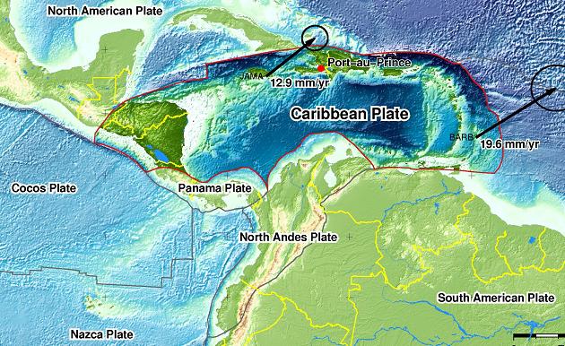
Notice in this map of the region how deep the waters of the Caribbean are. This is because the Caribbean Plate has been sinking, over time. Here's a diagram of the presumed land masses some 10 million years ago. A land bridge existed from the Florida region over to Venezuela, and the Caribbean offshore from Honduras and Nicaragua was likewise land.
SOURCE: http://www.fiu.edu/orgs/caribgeol/Caribtect/Carib010.gif
Looking at this complicated picture, just what portions of the Caribbean Plate will be pushed under as the S American Plate rolls? It certainly appears that the hump just north of Colombia, what some consider the North Andes Plate, would push over that portion of the Caribbean Plate just to the west of this hump. After all, the portion of the Caribbean Plate just to the west of this hump is deep water, so it has clearly been pushed down in the past. Presumably, also, the Caribbean Plate would hold together and move as one. If the southern portion of the Caribbean Plate were pushed down by this action, then Trinidad, Grenada, Barbados and the islands up toward Barbuda would likewise potentially be pushed down, with islands offshore from Central America likewise vulnerable."
end quoted
from:
SEARCH PS Ning or Zetatalk
Nancy Lieder, Emissary of the Zetas.
https://poleshift.ning.com/xn/detail/3863141:Comment:1168188
Awakening to the Alien Presence ZetaTalk
The truth will likely never to be known to the public but be washed away in the Nibiru panic soon to engulf the world.
The Worst of the Cover-Up
https://poleshift.ning.com/profiles/blogs/the-worst-of-the-cover-up
Main Establishment Lies
https://poleshift.ning.com/profiles/blogs/main-establishment-lies
Donate
© 2025 Created by 0nin2migqvl32.
Powered by
![]()
You need to be a member of Earth Changes and the Pole Shift to add comments!
Join Earth Changes and the Pole Shift