EARTHQUAKES Worldwide! (Frequently Updated)
 Global Earthquake Maps
Regionally Specific Earthquake Maps
|
Related Informations:
Earthquakes during the poleshift Magnetic twist and the effects
|
Additional Information from the F.A.Q: Q: What is the "Earth Wobble"?
Q: How can I understand the Magnetosphere? - About the Magnetosphere
Q: Is there a relationship between disturbances in the magnetosphere and seismic activity? |
Altering Earthquakes:
As of late, I have observed that USGS and EMSC are a bit lax on their reports of earthquakes. Sometimes not seeing anything reported for hours from the last update, or seeing periods of 90-200 minutes with no earthquakes in between. My question is, are they leaving swarms of earthquakes out of their reports, or there are actually periods of no earthquakes?
SOZT: Greater than 90% of the earthquake activity is being altered by the USGS at present, which is under orders to prevent any clue being given to the public about the Earth changes caused by the presence of Planet X. Over a decade ago, the approach was to de-sensitize the live seismographs periodically, so the displays do not turn black worldwide, and to ignore the twice-a-day patterns showing up on these seismographs. Then any quakes that could be dropped were dropped. This was obvious to some who were watching the database manipulation. Quakes in the list would suddenly disappear. This was particularly the case where a quake happened in a remote location, or out in the ocean. Dumbing down the magnitude quickly followed, but in order to ensure the public did not notice, the USGS took control of all websites reporting quake statistics. At times, this control breaks, and discrepancies are reported to the public. Some countries rebel. Quake swarms are another source of control, as they pepper the databases with many quakes and skew the statistics, and thus are pulled from the database. Else the question is raised, why so many? EOZT
Will the USGS internet system be a reliable warning system for the European tsunami by registering on the net the New Madrid earthquake on the exact time it occurs?
SOZT: It will not be a lack of information from the USGS that will be the point of confusion during the earthquakes leading up to the New Madrid adjustment, it will be knowing which quake is the big one vs the many minor quakes preceding it. The USGS downgrades almost all earthquakes, to prevent meaningful statistics from being generated from their databases. They also exclude quakes whenever they can, but this is unlikely to happen in the New Madrid area as it is in the center of a populated land mass. Thus you will have magnitude 6 quakes that will be called a 5.2, magnitude 7 quakes called a 6.1, and when a magnitude 8 or greater quake occurs, it will be called a 6.9.
We would advise that rather than watching the USGS quake statistics, that you watch the Earth changes. The adjustment that will incite the European tsunami will involve bridges on the Mississippi breaking, and being impassable. The land to the west of the Mississippi will drop so that the Mississippi will become 50 miles wide in the state of Mississippi. Watch for this. The New Madrid adjustment will be several large quakes of magnitude 8-9, though will be listed as a lesser magnitude. As the N American continent continues to unzip up to and along the Seaway, the quakes will be less than a magnitude 8 but very destructive to Cleveland and Toledo and Buffalo and the inland locks along the Seaway. Thus it is not what the USGS says that should be watched, but the condition of the bridges on the Mississippi, the impact on the cities along the Seaway, and whether the inland locks are reported as inoperable. EOZT
Please collect earthquake-reports here. Significant Quakes or Magnitude 7+ can be posted separately.
[Edited by the Moderation]
Views: 573675
Comment
-
Comment by jorge namour 6 hours ago
-
M 6.2 - 206 km S of Burica, Panama
2025-07-14 17:16:49 (UTC)6.179°N 82.681°W10.0 km depth
https://earthquake.usgs.gov/earthquakes/eventpage/us7000qclp/executive
-----------------------------------------------------------------------SPAIN REGION
FRKOM LINK
Two earthquakes hit close to Eurasia-Africa plate boundary
The first is 6.6
Depht 10km
And the second is moderate earthquake hit close to the coast of Spain
M5.2
Depht 10km https://earthquake.usgs.gov/earthquakes/eventpage/us7000qcif/executive#BREAKING: Airport roof collapses as Spain hit by powerful earthquake
.................................................................4.8
Izu Islands, Japan region
2025-07-14 13:53:18 (UTC-03:00)
10.0 km4.5
97 km SSW of Abepura, Indonesia
2025-07-14 11:24:26 (UTC-03:00)
27.9 km
3.2
36 km ESE of Malaga, New Mexico
2025-07-14 11:13:00 (UTC-03:00)
7.6 km
4.6
103 km NW of Ternate, Indonesia
2025-07-14 11:06:19 (UTC-03:00)
34.1 km
2.6
3 km W of Cobb, CA
2025-07-14 10:42:33 (UTC-03:00)
1.2 km
5.0
69 km NE of Masamba, Indonesia
2025-07-14 09:52:18 (UTC-03:00)
10.0 km
4.4
44 km ENE of Pedro Bay, Alaska
2025-07-14 09:18:02 (UTC-03:00)
134.8 km
4.7
80 km NE of Masohi, Indonesia
2025-07-14 08:37:02 (UTC-03:00)
10.0 km4.6
207 km E of Levuka, Fiji
2025-07-14 06:53:22 (UTC-03:00)
552.0 km
4.5
0 km SE of Kēng Tung, Burma (Myanmar)
2025-07-14 05:06:36 (UTC-03:00)
10.0 km
4.6
Auckland Islands, New Zealand region
2025-07-14 05:00:09 (UTC-03:00)
10.0 km5.0
228 km E of Ust’-Kamchatsk Staryy, Russia
2025-07-14 03:28:19 (UTC-03:00)
10.0 k4.1
43 km SSW of Jurm, Afghanistan
2025-07-13 18:18:38 (UTC-03:00)
191.8 km
4.3
31 km NE of Shwebo, Burma (Myanmar)
2025-07-13 18:04:00 (UTC-03:00)
10.0 km
-
Comment by Tracie Crespo 12 hours ago
-
Magnitude 6.7 Region KEP. TANIMBAR REGION, INDONESIA Date time 2025-07-14 05:49:58.1 UTC Location -6.198 ; 131.144 Depth 80 km Distance 430 km ESE of Ambon, Indonesia / pop: 355,000 / local time: 14:49:58.1 2025-07-14
189 km WSW of Tual, Indonesia / pop: 39,500 / local time: 14:49:58.1 2025-07-14Source parameters reviewed by a seismologist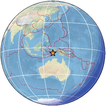
-
-
Terremoto de magnitud 5.7
Países afectados: El Salvador y Guatemala
A 5 km de Palín, Guatemala · 8 jul, 6:41 p.m.https://www.facebook.com/61578006503003/videos/pcb.1221027058409335...
VOLCAN O FUEGO AFTER M5.6 EARTHQUAKEMANY AFTERSHOCKS
2025-07-12 17:06:02
18 min ago
14.490 -90.670 5 3.5 GUATEMALA
2 2025-07-12 17:05:12
19 min ago
13.080 -89.850 5 3.5 OFFSHORE EL SALVADOR
2025-07-12 16:37:43
46 min ago
14.520 -90.660 9 2.9 GUATEMALA
---------------------------------------------------------------------2.9
36 km WSW of Mentone, Texas
2025-07-12 10:14:15 (UTC-03:00)
8.6 km4.9
51 km SSE of Pocito, Argentina
2025-07-12 03:52:33 (UTC-03:00)
128.7 km5.3
Kermadec Islands, New Zealand
2025-07-12 02:16:46 (UTC-03:00)
218.7 km
4.9
central Mid-Atlantic Ridge
2025-07-12 02:14:41 (UTC-03:00)
10.0 km
4.5
60 km ENE of Tobelo, Indonesia
2025-07-12 01:00:31 (UTC-03:00)
10.0 km
5.0
98 km N of Tatsugō, Japan
2025-07-11 23:01:23 (UTC-03:00)
10.0 km
4.8
103 km NNW of Tatsugō, Japan
2025-07-11 23:00:45 (UTC-03:00)
10.0 km
4.3
Reykjanes Ridge
2025-07-11 22:33:53 (UTC-03:00)
10.0 km
4.3
67 km ENE of Mutsu, Japan
2025-07-11 22:07:35 (UTC-03:00)
66.2 km
3.0
42 km NW of San Antonio, Puerto Rico
2025-07-11 22:06:22 (UTC-03:00)
15.1 km
3.6
110 km N of Charlotte Amalie, U.S. Virgin Islands
2025-07-11 21:24:33 (UTC-03:00)
47.0 km
4.7
271 km SSW of Teluk Dalam, Indonesia
2025-07-11 21:12:00 (UTC-03:00)
10.0 km
2.6
12 km NNW of New Harmony, Utah
2025-07-11 20:17:15 (UTC-03:00)
7.7 km
4.8
central Mid-Atlantic Ridge
2025-07-11 17:44:47 (UTC-03:00)
10.0 km
5.1
144 km N of Tual, Indonesia
2025-07-11 17:09:46 (UTC-03:00)
10.0 km
4.2
3 km NNE of Sarabetsu, Japan
2025-07-11 15:44:00 (UTC-03:00)
21.0 km4.5
50 km ESE of Rasht, Tajikistan
2025-07-12 12:16:53 (UTC-03:00)
8.9 km
-
-
M 6.3 - 212 km WSW of Riverton, New Zealand
2025-07-07 12:53:43 (UTC)47.317°S 165.607°E22.0 km depth
https://earthquake.usgs.gov/earthquakes/eventpage/us7000qb4s/executive
-----------------------------------------------------------------5.0
33 km SE of Palekastro, Greece
2025-07-07 14:46:04 (UTC-03:00)
10.0 km
4.5
38 km SSW of Challapata, Bolivia
2025-07-07 14:18:36 (UTC-03:00)
247.2 km2.5
5 km W of Rotan, Texas
2025-07-07 12:20:30 (UTC-03:00)
2.2 km4.4
22 km SSE of Yilan, Taiwan
2025-07-07 09:01:27 (UTC-03:00)
64.5 km5.1
259 km SSE of Port Blair, India
2025-07-07 07:16:03 (UTC-03:00)
10.0 km
4.9
113 km SSE of Port Blair, India
2025-07-07 06:42:46 (UTC-03:00)
10.0 km
4.9
Carlsberg Ridge
2025-07-07 06:42:21 (UTC-03:00)
10.0 km
4.4
20 km SSE of Akkeshi, Japan
2025-07-07 05:29:54 (UTC-03:00)
106.8 km
4.1
54 km S of Honchō, Japan
2025-07-07 03:55:31 (UTC-03:00)
44.3 km4.5
70 km SW of Lixoúri, Greece
2025-07-07 03:20:43 (UTC-03:00)
32.2 km4.5
Pearl and Hermes Atoll region, Hawaii
2025-07-06 21:27:15 (UTC-03:00)
10.0 km
5.5
65 km NE of ‘Ohonua, Tonga
2025-07-06 17:31:43 (UTC-03:00)
10.0 km
4.7
9 km NE of Parrita, Costa Rica
2025-07-06 16:59:58 (UTC-03:00)
44.2 km
-
-
2025-07-02 21:51:30
42 min ago
29.400 129.500 20 4.4 RYUKYU ISLANDS, JAPAN
2025-07-02 21:49:30
44 min ago
29.300 129.400 20 3.6 RYUKYU ISLANDS, JAPAN4.9
93 km NNW of Tatsugō, Japan
2025-07-02 14:32:56 (UTC-03:00)
10.0 km5.2
96 km NNW of Tatsugō, Japan
2025-07-02 12:49:18 (UTC-03:00)
10.0 k
4.6
101 km NNW of Tatsugō, Japan
2025-07-02 04:42:41 (UTC-03:00)
10.0 km
4.5
117 km NNW of Tatsugō, Japan
2025-07-02 04:29:13 (UTC-03:00)
10.0 km
5.0
99 km NNW of Tatsugō, Japan
2025-07-02 04:17:56 (UTC-03:00)
10.0 km5.2
94 km NNW of Tatsugō, Japan
2025-07-02 02:59:01 (UTC-03:00)
10.0 km
5.2
103 km NNW of Tatsugō, Japan
2025-07-02 02:53:26 (UTC-03:00)
10.0 km
5.2
90 km NNW of Tatsugō, Japan
2025-07-02 02:51:48 (UTC-03:00)
10.0 km5.1
58 km NNW of Tatsugō, Japan
2025-07-02 02:25:22 (UTC-03:00)
10.0 km
4.6
93 km NNW of Tatsugō, Japan
2025-07-02 02:22:17 (UTC-03:00)
10.0 kM 5.6 - 94 km NNW of Tatsugō, Japan
2025-07-02 06:26:49 (UTC)29.244°N 129.244°E10.0 km depth
https://earthquake.usgs.gov/earthquakes/eventpage/us7000qa5e/executive
----------------------------------------------------------------------------5.2
South Sandwich Islands region
2025-07-02 13:58:04 (UTC-03:00)
35.0 km4.3
69 km W of El Habillal, Mexico
2025-07-02 14:06:01 (UTC-03:00)
38.2 km4.5
105 km W of El Aguilar, Argentina
2025-07-02 08:11:25 (UTC-03:00)
201.8 km
4.2
south of the Fiji Islands
2025-07-02 07:59:07 (UTC-03:00)
561.1 km
4.2
5 km NE of Gemlik, Turkey
2025-07-02 07:57:43 (UTC-03:00)
10.0 km4.7
Carlsberg Ridge
2025-07-02 02:41:16 (UTC-03:00)
10.0 km4.6
Carlsberg Ridge
2025-07-02 01:39:28 (UTC-03:00)
10.0 km
3.6
19 km N of Punta Cana, Dominican Republic
2025-07-02 01:17:35 (UTC-03:00)
63.0 km4.4
Carlsberg Ridge
2025-07-02 01:09:11 (UTC-03:00)
10.0 km5.4
south of the Fiji Islands
2025-07-01 23:57:17 (UTC-03:00)
10.0 km5.5
81 km W of Cartagena, Chile
2025-07-01 22:39:39 (UTC-03:00)
10.0 km
-
-
Magnitude 6.6 Region SCOTIA SEA Date time 2025-06-28 08:32:21.0 UTC Location -60.962 ; -38.949 Depth 10 km Distance 2091 km E of Punta Arenas, Chile / pop: 117,000 / local time: 05:32:21.0 2025-06-28
1546 km ESE of Stanley, Falkland Islands / pop: 2,200 / local time: 05:32:21.0 2025-06-28Source parameters provided by:
National Earthquake Information Center, U.S. Geological Survey -- Golden, United States (NEIC)
-
-
Magnitude 6.1 Region MINDANAO, PHILIPPINES Date time 2025-06-27 23:07:10.1 UTC Location 5.277 ; 126.098 Depth 102 km Distance 138 km ESE of General Santos, Philippines / pop: 679,000 / local time: 07:07:10.1 2025-06-28
72 km E of Sarangani, Philippines / pop: 7,500 / local time: 07:07:10.1 2025-06-28Source parameters provided by:
National Earthquake Information Center, U.S. Geological Survey -- Golden, United States (NEIC)
-
-
M 6.2 - east of the Philippine Islands
2025-06-24 01:58:05 (UTC)7.988°N 129.859°E5.0 km depth
https://earthquake.usgs.gov/earthquakes/eventpage/us7000q8bd/executive
----------------------------------------------------------
M 5.7 - 77 km NNE of Punta Cana, Dominican Republic
2025-06-24 02:45:43 (UTC)19.225°N 68.110°W68.0 km depth
https://earthquake.usgs.gov/earthquakes/map/?extent=13.68869,-78.24...
....................................................4.5
93 km NNW of Tatsugō, Japan
2025-06-24 04:54:09 (UTC-03:00)
10.0
102 km NNW of Tatsugō, Japan
2025-06-24 04:04:14 (UTC-03:00)
10.0 km4.8
85 km S of Kushiro, Japan
2025-06-23 14:55:12 (UTC-03:00)
33.9 km5.0
108 km NNW of Tatsugō, Japan
2025-06-23 14:23:29 (UTC-03:00)
10.0 km5.1
106 km N of Tatsugō, Japan
2025-06-23 11:36:19 (UTC-03:00)
10.0 km
4.5
94 km NNW of Tatsugō, Japan
2025-06-23 11:17:52 (UTC-03:00)
10.0 kfrtom link On going earthquakes south of Japan
......................................................5.0
285 km SSE of Port Blair, India
2025-06-24 10:12:23 (UTC-03:00)
10.0 km4.9
282 km SSE of Port Blair, India
2025-06-24 07:16:58 (UTC-03:00)
10.0 km
4.6
Nicobar Islands, India region
2025-06-24 06:04:15 (UTC-03:00)
10.0 kmmagnitud 5.5
A 106 km de Kirakira, Islas Salomón · 23 jun, 10:58 p.m.magnitud 6.0
Países afectados: Japón y Rusia
A 84 km de Nemuro, Hokkaidō, Japón · 21 jun, 6:23 p.m.magnitud 5.9
Países afectados: Japón y Rusia
A 91 km de Nemuro, Hokkaidō, Japón · 18 jun, 8:08 p.m.
-
-
https://www.emsc-csem.org/Earthquake_information/earthquake.php?id=...
Magnitude 5.8 Region OFF COAST OF CHIAPAS, MEXICO Date time 2025-06-18 09:49:23.3 UTC Location 14.911 ; -94.042 Depth 11 km Distance 192 km W of Tapachula, Mexico / pop: 202,000 / local time: 03:49:23.3 2025-06-18
117 km S of Cabeza de Toro, Mexico / pop: 3,400 / local time: 03:49:23.3 2025-06-18Source parameters reviewed by a seismologist ------------------------------------------------------------------------------------------------------------------------------------------------------------
Magnitude 5.4 Region OFFSHORE EL SALVADOR Date time 2025-06-18 11:57:25.4 UTC Location 13.116 ; -88.577 Depth 90 km Distance 59 km SW of San Miguel, El Salvador / pop: 161,000 / local time: 05:57:25.4 2025-06-18
19 km S of Puerto El Triunfo, El Salvador / pop: 19,000 / local time: 05:57:25.4 2025-06-18Source parameters reviewed by a seismologist

-
-
Magnitude 6.5 Region KURIL ISLANDS Date time 2025-06-13 18:35:11.5 UTC Location 46.156 ; 153.288 Depth 9 km Distance 784 km ENE of Kitami, Japan / pop: 113,000 / local time: 03:35:11.5 2025-06-14
433 km ENE of Kuril’sk, Russia / pop: 1,600 / local time: 03:35:11.5 2025-06-14Source parameters not yet reviewed by a seismologist
© 2025 Created by 0nin2migqvl32.
Powered by
![]()
You need to be a member of Earth Changes and the Pole Shift to add comments!
Join Earth Changes and the Pole Shift