Large Aceh Quake Triggers Indian Ocean Tsunami Warning (NEW ZetaTalk re 7 of 10 Significance!)
An earthquake with an initial magnitude of 8.9 has struck under the sea off Indonesia's northern Aceh province.
The quake triggered a tsunami warning across the Indian Ocean region.
The Pacific Tsunami Warning Center said it was not yet known whether a tsunami had been generated, but advised authorities to "take appropriate action".
The region is regularly hit by earthquakes. The Indian Ocean tsunami of 2004 killed 170,000 people in Aceh.
The US Geological Survey, which documents quakes worldwide, said the Aceh quake was centred 33km (20 miles) under the sea about 495km from Banda Aceh, the provincial capital.
It was initially reported as 8.9 magnitude but was later revised down to 8.7 by the USGS.
The tsunami centre's warning said quakes of such a magnitude "have the potential to generate a widespread destructive tsunami that can affect coastlines across the entire Indian Ocean basin".
The tremor was felt as far away as Singapore, Thailand and India.
Reuters reports that people in the region were making their way to higher ground.
The BBC's Karishma Vaswani in the Indonesian capital Jakarta says there were reports of the ground shaking for up to five minutes. Contact with people in the immediate area around the quake has not been possible so far, says our correspondent.
Indonesia straddles the Pacific Ring of Fire, a zone of major seismic activity.
Source: Large Aceh quake triggers Indian Ocean tsunami warning
^^^^^^^^^^^^^^^^^^^^^^^^^^^^^^^^^^^^^^^^^^^^^^^^^^^^^^^^^^^^^^^^^^^^^^^^^^^^^^^
Comment by Nancy Lieder
New ZT early on this matter, with graphics interspirsed.
SOZT
Several facts quickly became obvious after the magnitude 8.9 quake on April 11, 2012 off the coast of Sumatra. First, the tsunami experienced on December 26, 2004 did not repeat. In 2004 the plate holding India lifted, thus displacing a massive amount of water in all directions, and thus the tsunami and high death count. In 2012 the plates slide along each other, with at most a temporary void along the plate borders causing buoy 55015 to show an amazing temporary drop 65 meters (195 feet). This did not result in a tsunami because the water merely roiled in the void and then found its level, and did not travel to the side to disburse.
The second fact emerged by the next day, on the IRIS charts. The West Coast of the US had numerous substantial quakes, a continuing adjustment following the magnitude 7.9 near Acapulco, but clearly more than this was involved. The plates WORLDWIDE were adjusting. Look at the buoy chart. Buoys on alert are doing more than outlining the Sunda Plate. They are outlining the folding Mariana Plate, and the rising eastern edge of the plate holding Australia. The quakes on the IRIS chart show quakes on either side of Africa also, as that plate adjusted. But the big surprise was the amount of adjustment in the northern Pacific, between the West Coast of the US and Mexico and Japan and the folding Mariana Plate.
What occurred during the Sumatra quake was a shifting to the west of the plate holding India, such that there were those small voids along the plate border with Sumatra announced by the buoys. This does indeed relate to the crack occurring just days before along the suspension bridge up in the Himalayas along the Thailand/India border. Africa had been edging to the west also, as the Atlantic spread, and this allowed the plate holding India to make this move. During this adjustment, any snags holding the folding Mariana Plate back were eased, and both the Mariana and Philippine plates gave in to the pressure from the Pacific. This allowed the southern part of the N American bow to shift further west also.
Did we not predict that the spreading Atlantic would allow a dropping and twisting Africa to fall into the increasing VOID in the Indian Ocean? Did we not predict that Mariana and Philippine plates would tilt and fold during the 7 of 10 scenarios? Why else are the buoys in that region on alert, so far from the slip-slide to the west of Sumatra? Did we not predict that the N American continent would tighten into a bow as the 7 of 10 plate adjustments proceeded? Here we have the entire West Coast from Vancouver to Acapulco suddenly having significant quakes. We stated the plates had been loosened, and were on the move. Our 7 of 10 predictions have become a FACT.
EOZT
Views: 13630
Comment
-
Comment by Kris H on April 11, 2012 at 8:48pm
-
We are nearing the end of the Spring trimester. The Zetas warned that the start of the Summer trimester would become a bigger "jolt" than the end of the Winter trimester.
http://zetatalk.com/ning/19fe2011.htm
See answer to first Q on linked chat.
-
Comment by Recall 15 on April 11, 2012 at 7:52pm
-
Hello Tammy, just imagine to try to move the tectonic plates from East of Arabic Sea to Australia, and from Australia to Kamchatka, and lift these triangular area just 10cm/0.32ft ...
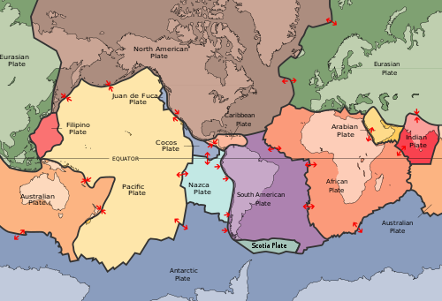 Image from:
-
Comment by Stanislav on April 11, 2012 at 7:30pm
-
-
Comment by Mark on April 11, 2012 at 6:43pm
-
And happening just when David Cameron is in Jakarta as part of an Asian tour - no doubt checking out the sinking plate effects while he is there. I bet the quakes will give them lots to talk about in their face-to-face meetings!
http://www.voanews.com/english/news/asia/Britains-Cameron-Discusses...
-
Comment by Howard on April 11, 2012 at 6:34pm
-
@tammyhogan - The degree of change in water column height is not nearly as significant as the speed in which the change occurs. The red plots are showing rapid fluctuations in water column height which is indicative of sudden movement in the ocean floor bottom.
-
Comment by astrogal50 on April 11, 2012 at 6:14pm
-
Note to Cover Up Artists: Please do not bother blaming this huge quake and the aftershocks on fracking and/or oil and gas drilling. No one with an ounce of common sense is going to believe that Establishment Lie applies here! (People should not accept the USGS' claim that fracking or drilling causes earthquakes.)
-
-
Did someone already comment that this has been lowered to an 8.6? Quakes close to 9 are incredibly rare, normally.
-
-
Data of Buoy 21416 - 240NM SE of Kamchatka Peninsula
From Direct Link:
http://www.ndbc.noaa.gov/station_page.php?station=21416&type=2&...
-
-
Data of Buoy 21419 - 209NM SE of KURIL ISLANDS
From Direct Link:
http://www.ndbc.noaa.gov/station_page.php?station=21419&type=2&...
-
-
Data of Buoy 21401 - 250NM Southeast of Iturup Island
From Direct Link:
http://www.ndbc.noaa.gov/station_page.php?station=21401&type=2&...
SEARCH PS Ning or Zetatalk
Nancy Lieder, Emissary of the Zetas.
https://poleshift.ning.com/xn/detail/3863141:Comment:1168188
Awakening to the Alien Presence ZetaTalk
The truth will likely never to be known to the public but be washed away in the Nibiru panic soon to engulf the world.
The Worst of the Cover-Up
https://poleshift.ning.com/profiles/blogs/the-worst-of-the-cover-up
Main Establishment Lies
https://poleshift.ning.com/profiles/blogs/main-establishment-lies
Donate
© 2025 Created by 0nin2migqvl32.
Powered by
![]()
You need to be a member of Earth Changes and the Pole Shift to add comments!
Join Earth Changes and the Pole Shift