Hawaii in upheaval. Biggest deep sea volcanic eruption in 100 years went unnoticed in 2012!
References: Earthquake data [1]
ZetaTalk Prediction 4/15/1999: You're going to have increasing earthquake tremblers. This will be defused by the media which will fail to report them.
ZetaTalk: Christmas Hammer 12/21/2007: Great quakes that affect the globe in its entirety must first occur at one of the brake points in the global mesh of plates. For the Earth, this is primarily the point where the Indo-Australian plate dives under the Himalayas.
ZetaTalk: Hawaii: Hawaii is steadily rising now, after every major quake in the vicinity. As we explained, the Pacific is not one plate but at least four, and both the Hawaii Islands and the Society Islands are being raised on the western edge of a the Pacific Plate portion that is subducting under the West Coast of N America.
Tectonic activity increased significantly in Hawaii. The eruption of the volcano is accompanied by the appearance of new cracks from which the lava flows. Thousands of small earthquakes hit Hawaii. Although in itself the volcanic eruptions in Hawaii is not a new event. The large earthquake that shocked Hawaii points to some uniqueness of this event.
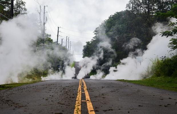 Steam rises from a fissure on a road in Leilani Estates subdivision on Hawaii's Big Island on May 4, 2018. - Up to 10,000 people have been asked to leave their homes on Hawaii's Big Island following the eruption of the Kilauea volcano that came after a series of recent earthquakes. FREDERIC J. BROWN / AFP/GETTY IMAGES. Image source: cbsnews.com
The strength of this earthquake is what is remarkable. This is largest earthquake since 1975 and second-strongest ever in Hawaii. [2]

A 2,000-foot-long fissure erupts within the Leilani Estates subdivision, on the east rift zone of the Kilauea volcano threatening homes of hundreds in Hawaii, on May 5, 2018. Bruce Omori / Paradise Helicopters / EPA-EFE / REX / Shutterstock. Image source: nytimes.com
Kilauea volcano active since 1983. And it constantly erupts and there is nothing unusual about it.
 An ash plume at the Kilauea volcano on Friday on Hawaii. The governor declared a local state of emergency near the volcano after it erupted and prompted the evacuation of residents.CreditU.S. Geological Survey, via Getty Images. Image source: nytimes.com
"5 May, 2018. Hawaii rocked by strongest quake in 40 years as Kilauea volcano sparks fountains of lava
A series of fresh earthquakes on Friday, including a powerful magnitude 6.9, hit Hawaii's Big Island, where the Kilauea volcano has been spewing fountains of lava into residential areas and forcing hundreds to evacuate. The US Geological Survey (USGS) said the strongest tremor at 12.32 pm measured 6.9, the island's largest earthquake in more than 40 years.
The Pacific Tsunami Warning Centre said the quake, whose epicentre was on the south flank of the volcano, was not large enough to cause a tsunami although it generated sea level changes around the island of up 40 cm. - [1] writes telegraph
Hawaii
References: Earthquake data [2]
These earthquakes were caused by volcanic activity:
"5 May, 2018. Multiple new vents, from which lava is spurting out of the ground, formed in the same residential neighborhood where molten rock first emerged Thursday. At midday, a magnitude 6.9 earthquake struck—the biggest of hundreds of quakes this week and the largest to strike the state in 43 years. Residents were also warned to watch out for dangerous levels of sulfuric gas.
Hawaiian Volcano Observatory spokeswoman Janet Babb said the earthquakes reflected the volcano adjusting to the shifting magma.
"The magma moving down the rift zones, it causes stress on the south flank of the volcano," Babb said. "We're just getting a series of earthquakes."" [4]
References: Earthquake data [2]
Hundreds of earthquakes shook Hawaii this week
References: Earthquake data [2], [3]
One of them was a record in 40 years.
2012 Kermadec Islands eruption
But this is all nothing compared to this news:
"15 January, 2018. We All Nearly Missed The Largest Underwater Volcano Eruption Ever Recorded
 Image source: thetimes.co.uk
"We knew it was a large-scale eruption, approximately equivalent to the biggest eruption we've seen on land in the 20th Century," says volcanologist Rebecca Carey from the University of Tasmania, who's co-led the first close-up investigation of the historic 2012 eruption.
The incident, produced by a submarine volcano called the Havre Seamount, initially went unnoticed by scientists, but the floating rock platform it generated was harder to miss.
Back in 2012, the raft – composed of pumice rock – covered some 400 square kilometres (154 square miles) of the south-west Pacific Ocean, but months later satellites recorded it dispersing over an area twice the size of New Zealand itself.
 Scientists used deep search vehicles to map the eruption and collect samples. WOODS HOLE OCEANOGRAPHIC INSTITUTION. Image source: thetimes.co.uk
Under the surface, the sheer scale of the rocky aftermath took scientists aback when they inspected the site in 2015, at depths as low as 1,220 metres (4,000 feet).
It may have been (thankfully) buried under an ocean of water, but for a sense of scale, think roughly 1.5 times larger than the 1980 eruption of Mount St. Helens – or 10 times the size of the 2010 Eyjafjallajokull eruption in Iceland. With samples collected by the submersibles yielding what the scientists say could amount to a decade's worth of research, it's a huge, rare opportunity to study what takes place when a volcano erupts under the sea – a phenomenon that actually accounts for more than 70 percent of all volcanism on Earth, even if it's a bit harder to spot.
"Underwater eruptions are fundamentally different than those on land," says one of the team, geophysicist Michael Manga from UC Berkeley. "There is no on-land equivalent."" [5]
The eruption occurred in July 2012 near New Zealand, while in April in the Indian Ocean there was an unusual earthquake with magnitude 8.6 (largest strike-slip earthquake ever recorded). Coincidence?
Conclusion:
Of course volcanic activity in Hawaii is not new. What is worth paying attention to is seismic activity. The earthquake that shook Hawaii is remarkable and record.
 This photo provided by Shane Turpin shows results of the eruption from Kilauea Volcano on Hawaii's Big Island Friday, May 4, 2018. The eruption sent molten lava through forests and bubbling up from paved streets and forced the evacuation of about 1,500 people who were still out of their homes Friday after Thursday's eruption. (Shane Turpin/seeLava.com via AP). Image source: phys.org
It's difficult to conclude what this means globally. By itself, this earthquake of course does not mean anything. But the earthquakes in Mexico, Korea and Botswana also adds "weight".
References:
[1] Staff, R. S. (2018, May 05). Hawaii rocked by strongest quake in 40 years as Kilauea volcano sparks fountains of lava. Retrieved May 6, 2018, from https://www.telegraph.co.uk/news/2018/05/05/hawaiis-kilauea-volcano...
[2] https://earthquake.usgs.gov/
[3] https://earthquake.usgs.gov/learn/topics/calculator.php
[4] Jones, C., & Garcia, M. (2018, May 5). Hawaii's Kilauea volcano jolts with lava, quakes and gas. Retrieved May 6, 2018, from https://phys.org/news/2018-05-hawaii-kilauea-volcano-jolts-lava.html
[5] Dockrill, P. (2018, January 15). We All Nearly Missed The Largest Underwater Volcano Eruption Ever Recorded. Retrieved May 6, 2018, from https://www.sciencealert.com/almost-nobody-noticed-largest-underwat...
Views: 3420
Comment
-
Comment by Howard on June 2, 2018 at 6:16pm
-
Quake map near Kilauea for May 2018.
Source
https://volcanoes.usgs.gov/volcanoes/kilauea/monitoring_data2.html
-
Comment by jorge namour on June 2, 2018 at 5:01pm
-
5.4
Volcanic Eruption 5km SW of Volcano, Hawaii
2018-06-01 23:37:15 (UTC)
0.4 km https://earthquake.usgs.gov/earthquakes/eventpage/hv70219637#executiveUSGS
2.6
5km WSW of Volcano, Hawaii
2018-06-01 23:29:37 (UTC)
0.4 km
2.7
5km SW of Volcano, Hawaii
2018-06-01 23:27:21 (UTC)
0.9 km
2.5
6km SW of Volcano, Hawaii
2018-06-01 23:25:34 (UTC)
0.8 km
3.1
1km ESE of Pahala, Hawaii
2018-06-01 23:09:48 (UTC)
34.3 km
2.6
6km SW of Volcano, Hawaii
2018-06-01 22:39:09 (UTC)
1.4 km
2.8
6km WSW of Volcano, Hawaii
2018-06-01 22:23:19 (UTC)
0.0 km
3.2
6km WSW of Volcano, Hawaii
2018-06-01 22:14:09 (UTC)
-1.0 km
3.0
78km NE of Santa Barbara de Samana, Dominican Republic
2018-06-01 21:57:59 (UTC)
34.0 km
3.2
5km SW of Volcano, Hawaii
2018-06-01 21:53:56 (UTC)
0.7 km
2.9
6km WSW of Volcano, Hawaii
2018-06-01 21:50:43 (UTC)
0.1 km
3.1
5km WSW of Volcano, Hawaii
2018-06-01 21:50:12 (UTC)
0.3 km
2.8
6km SW of Volcano, Hawaii
2018-06-01 21:48:43 (UTC)
0.6 km
2.5
5km SW of Volcano, Hawaii
2018-06-01 21:47:48 (UTC)
1.0 km
2.5
18km SE of Volcano, Hawaii
2018-06-01 21:44:18 (UTC)
4.5 km
3.8
17km SE of Volcano, Hawaii
2018-06-01 21:32:22 (UTC)
6.4 km
2.5
4km SW of Volcano, Hawaii
2018-06-01 21:29:38 (UTC)
1.1 km
2.6
10km WSW of Volcano, Hawaii
2018-06-01 21:29:34 (UTC)
-1.1 km
2.6
10km SW of Volcano, Hawaii
2018-06-01 21:25:27 (UTC)
-0.0 km
2.5
3km S of Volcano, Hawaii
2018-06-01 21:19:50 (UTC)
2.8 km
2.6
6km WSW of Volcano, Hawaii
2018-06-01 21:04:20 (UTC)
0.3 km
2.8
1km SE of Volcano, Hawaii
2018-06-01 21:03:56 (UTC)
-0.3 km
2.6
6km SW of Volcano, Hawaii
2018-06-01 21:01:04 (UTC)
1.5 km
2.5
5km SW of Volcano, Hawaii
2018-06-01 20:54:04 (UTC)
0.4 km
-
-
World Seismology
·BLUE FLAMES IN #HAWAII
In Leilani Estates appear burning blue flames of methane gas.https://www.facebook.com/SismoMundial/photos/a.806107496124749.1073...
-
-
https://www.facebook.com/USGSVolcanoes/posts/2033297033365514
https://www.facebook.com/USGSVolcanoes/photos/a.984262971602264.107...
USGS Volcanoes
Here is a screen shot from the HVO Observation Tower webcam, with a view of the ash plume resulting from an early morning explosion at Kīlauea Volcano's summit.
Staffs from HVO and Hawai'i Volcanoes National Park had already evacuated the area.
https://www.facebook.com/lavanews/videos/204580503665588/?hc_ref=AR...
Since everybody’s all talking about the new fissures I thought it might be smart to go ahead and bring up the issue of cracks they’re getting much bigger especially here at the lower part of Leilani to be exact this one shot yesterday is at the bottom of Leilani and Pohoiki
-
-
Live Panorama of Kīlauea Caldera from HVO Observation Tower [KIcam]
Last Updated 2018-05-14 08:00:05 (HST), 2018-05-14 15:00:05 (local)https://volcanoes.usgs.gov/observatories/hvo/webcam.html?webcam=KIcam
-
-
Big Island Video News
Volcano Planet
2 hrs · MAY 13 2018
BREAKING: New fissure (18) opens, residents of Hale Kamahina Loop Road must evacuate.
http://www.bigislandvideonews.com/2018/05/13/eruption-notice-new-fi...
-
-
Big Island Video News
4 hrs ·
BREAKING NEWS: New Volcanic Activity Notice issued. Scientists are growing more concerned as the summit lava lake drops out of view. If the lava column drops to the level of groundwater beneath Kīlauea Caldera, influx of water into the conduit could cause steam-driven explosions.http://www.bigislandvideonews.com/2018/05/09/new-volcanic-activity-...
https://www.facebook.com/USGSVolcanoes/posts/2025094700852414
USGS Volcanoes
2 hrs ·
Rockfall generates a short-lived explosion at Halema‘uma‘u crater, at 8:27 a.m. HST, May 9.An ash column rises from the Overlook crater at the summit of Kīlauea Volcano today. The USGS-Hawaiian Volcano Observatory's interpretation is that the explosion was triggered by a rockfall from the steep walls of Overlook crater.
This photograph was taken at 8:29 a.m. HST on May 9, from the Jaggar Museum overlook. The explosion was short-lived. Geologists examining the ash deposits on the rim of Halema‘uma‘u crater found fresh lava fragments hurled from the lava lake. This explosion was not caused by the interaction of the lava lake with the water table. When the ash cleared from the crater about an hour after the explosion, geologists were able to observe the lava lake surface, which is still above the water table.
© 2025 Created by 0nin2migqvl32.
Powered by
![]()
You need to be a member of Earth Changes and the Pole Shift to add comments!
Join Earth Changes and the Pole Shift