7 of 10 SINKING Real Time Satellite Image - ADDITIONAL Images
Source: Real time satellite image Asia
Photos speak for themselves!
Indonesia SINKING:
Each month, I took one photo to show the fluctuation of flooding. I took a neat cloud-free image
12/30/2011
The sea is connected to the flood!
Duration flood:
11/27/2011
08/30/2011
07/31/2011
06/25/2011
05/29/2011
Mynamr SINKING:
12/31/2011
And so you did not think that this has always been here:
Duration of flooding:
Other map here:
http://lance-modis.eosdis.nasa.gov/imagery/subsets/?area=sea
^^^^^^^^^^^^^^
Bangladesh SINKING:
Cambodia SINKING:
12/30/2011
7 of 10 sinking
Views: 6975
Comment
-
Comment by Nancy Lieder on January 3, 2012 at 5:35pm
-
I have researched the website @Stanislav located and am including some shots in my upcoming newsletter, 7 of 10 STATUS etc. Posting here first!
^^^^^^^^^^^^^^^^^^^^^^^^^^^^^^^
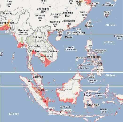
For Java, it is notable that where the area near the city of Jakarta has been remarkably spared, other parts of the north coast of Java appear to be at a 40 foot elevation loss. Some inland areas of Java also appear to be flooded, not draining. An 80 foot elevation drop is predicted
http://www.zetatalk12.com/info/tinfx341.htm
by the Zetas when sinking has completed.
Manila has clearly sunk north of the bay and to the southeast of Manila, as predicted, and seems to be at the 40 foot loss predicted by the Zetas as of the end of 2011. Bangkok has not recovered from its floods, nor will it, despite the claims that this was only river drainage. Here again the flooding from sinking seems to equate to the 40 foot mark predicted by the Zetas.
The island of Borneo is expected to suffer an 80 foot drop, but seems to only again be at the HALF way mark. But the tip of Viet Nam appears to be devastated, closer to its predicted 40 foot drop with the loss of sea level reaching inland to Cambodia.
SEARCH PS Ning or Zetatalk
Nancy Lieder, Emissary of the Zetas.
https://poleshift.ning.com/xn/detail/3863141:Comment:1168188
Awakening to the Alien Presence ZetaTalk
The truth will likely never to be known to the public but be washed away in the Nibiru panic soon to engulf the world.
The Worst of the Cover-Up
https://poleshift.ning.com/profiles/blogs/the-worst-of-the-cover-up
Main Establishment Lies
https://poleshift.ning.com/profiles/blogs/main-establishment-lies
Donate
© 2025 Created by 0nin2migqvl32.
Powered by
![]()
You need to be a member of Earth Changes and the Pole Shift to add comments!
Join Earth Changes and the Pole Shift