Please Place Evidence of the 7 of 10 Plate Movements Here
Kojima had created small snips of Konstantin's animation of the 7 of 10 Plate Movements.
Here is the full 7 of 10 Animation by Konstantin.
This blog is the place to document ongoing earth changes related to the 7 of 10 plate movements as described by the Zetas.
ZetaTalk: 7 of 10 Sequence
written October 16, 2010
The 7 of 10 scenarios describe plate movements, and for this to occur something has to release the deadlock, the current stalemate where the plates are locked against each other. Once the deadlock is broken and the plates start moving, sliding past each other, new points where the plates are locked against each other develop, but these are weaker locks than the one at present. The current lock, as we have so often stated, is the Indo-Australian Plate which is being driven under the Himalayans. This is no small lock, as the height of the Himalayans attests. Nevertheless, the activity in this region shows this likely to be the first of the 7 of 10 scenarios to manifest. Bangladesh is sinking and the Coral Sea is rising, showing the overall tipping of the Indo-Australian Plate. Now Pakistan is sinking and not draining its floods as it should, while Jakarta on the tongue of Indonesia is also sinking rapidly, showing that the tilt that will allow Indonesia to sink has already started.
Meanwhile, S America is showing signs of a roll to the west. Explosions on islands just to the north of the S American Plate occurred recently, on Bonaire and Trinidad-Tobago, and the Andes are regularly being pummeled. There is a relationship. As the Indo-Australia Plate lifts and slides, this allows the Pacific plates to shift west, which allows S America to shift west also. This is greatly increased by the folding of the Mariana Trench and the Philippine Plate. But it is the Indo-Australian Plate that gives way to incite change in these other plates, and this is what is manifesting now to those closely following the changes. Once the folding of the Pacific has occurred, Japan has been destabilized. We are not allowed to give a time frame for any of these plate movements, but would point out that it is not until the North Island of Japan experiences its strong quakes that a tsunami causing sloshing near Victoria occurs. There are clues that the New Madrid will be next.
Where the N American continent is under great stress, it has not slipped because it is held in place on both sides. The Pacific side holds due to subduction friction along the San Andreas, and the Atlantic side holds due to the Atlantic Rift's reluctance to rip open. What changes this dynamic? When S America rolls, almost in step with the folding Pacific, it tears the Atlantic Rift on the southern side. This allows Africa freedom to move and it rolls too, dropping the Mediterranean floor above Algeria. What is holding the N American continent together has thus eased, so that when the Japan adjustments are made, there is less holding the N American continent in place than before, and the New Madrid gives way. We are also not allowed to provide the time frame between the Japan quakes and New Madrid. Other than the relationship in time between the New Madrid and the European tsunami, no time frame can be given. The sequence of events is, thus:
- a tipping Indo-Australia Plate with Indonesia sinking,
- a folding Pacific allowing S America to roll,
- a tearing of the south Atlantic Rift allowing Africa to roll and the floor of the Mediterranean to drop,
- great quakes in Japan followed by the New Madrid adjustment,
- which is followed almost instantly by the tearing of the north Atlantic Rift with consequent European tsunami.
Source: http://www.zetatalk.com/index/zeta584.htm
Tipping Indo-Australia Plate with Indonesia sinking,
http://zetatalk.com/7of10/7of10-23.htm
http://zetatalk.com/7of10/7of10-24.htm
http://zetatalk.com/7of10/7of10-25.htm
http://zetatalk.com/7of10/7of10-26.htm
http://zetatalk.com/7of10/7of10-28.htm
http://zetatalk.com/7of10/7of10-30.htm
http://zetatalk.com/7of10/7of10-31.htm
http://zetatalk.com/7of10/7of10-32.htm
http://zetatalk.com/7of10/7of10-34.htm
http://zetatalk.com/7of10/7of10-37.htm
Folding Pacific
http://zetatalk.com/7of10/7of10-33.htm
http://zetatalk.com/7of10/7of10-38.htm
http://www.zetatalk.com/info/tinfx351.htm
http://zetatalk.com/7of10/7of10-47.htm
South American Roll
http://zetatalk.com/7of10/7of10-39.htm
http://zetatalk.com/7of10/7of10-40.htm
http://zetatalk.com/7of10/7of10-41.htm
http://zetatalk.com/7of10/7of10-42.htm
http://zetatalk.com/7of10/7of10-43.htm
http://zetatalk.com/7of10/7of10-44.htm
http://zetatalk.com/7of10/7of10-45.htm
http://zetatalk.com/7of10/7of10-47.htm
African Roll
http://www.zetatalk.com/7of10/7of10-46.htm
http://zetatalk.com/7of10/7of10-47.htm
http://zetatalk.com/7of10/7of10-48.htm
http://zetatalk.com/7of10/7of10-52.htm
Japan Quakes
http://www.zetatalk.com/7of10/7of10-53.htm
http://zetatalk.com/7of10/7of10-54.htm
New Madrid
http://www.zetatalk.com/7of10/7of10-59.htm
http://www.zetatalk.com/7of10/7of10-60.htm
http://zetatalk.com/7of10/7of10-61.htm
http://www.zetatalk.com/7of10/7of10-62.htm
http://zetatalk.com/7of10/7of10-63.htm
http://zetatalk.com/7of10/7of10-64.htm
http://zetatalk.com/7of10/7of10-65.htm
http://zetatalk.com/7of10/7of10-68.htm
European Tsunami
http://zetatalk.com/7of10/7of10-70.htm
http://zetatalk.com/7of10/7of10-71.htm
http://zetatalk.com/7of10/7of10-72.htm
http://zetatalk.com/7of10/7of10-73.htm
http://zetatalk.com/7of10/7of10-74.htm
Due to the slowing of the 7 of 10 plate movements by the Council of Worlds the impact of some of the events described above will be lessened.
The Zetas explain:
ZetaTalk: Pace Slowed
Written May 19, 2012
The effect of the thousands of humming boxes placed along fault lines and plate borders can be seen in several incidents that have occurred since the start of the 7 of 10 plate movements. The lack of tsunami during the 7 of 10 sinking of the Sunda Plate is one such example. We predicted at the start of the 7 of 10 scenarios in late 2010 that the Sunda Plate sinking would occur within 2-3 weeks, yet it dragged on through 2011. At the time we had predicted tsunami on the Sunda Plate, in general equivalent in height to the loss of elevation for a coastline. None of this occurred due to the slower pace.
The pace of mountain building in S America, where slowed, has still resulted in rumpling up and down the Andes, and stretch zone accidents likewise in lands to the east of the Andes. The shape of S America has clearly changed. Will the islands in the Caribbean be spared? At some point, as with the magnitude 7.9 quake in Acapulco on March 2, 2012 a significant adjustment will need to occur, and this will include depressing the Caribbean Plate so it tilts, sinking the islands and lands on that portion of the plate to the degree predicted. But the S American roll will likely continue to avoid the magnitude 8 quakes we originally predicted in deference to slow rumpling mountain building. The African roll was anticipated to be a silent roll in any case, so the slowed pace would not affect the outcome.
Will the slowed pace prevent the 7 of 10 scenarios for the Northern Hemisphere? Bowing of the N American continent has reached the point of pain, with breaking rock booming from coast to coast, but still there have been no significant quakes in the New Madrid area. Yet this is past due, and cannot be held back indefinitely. What has and will continue to occur for the Northern Hemisphere scenarios are silent quakes for Japan, which has already experienced drastic subduction under the north island of Hokkaido where mountain building is occurring as a rumple rather than a jolt. However, the anticipated New Madrid adjustment cannot be achieved without trauma. But this could potentially occur in steps and stages such that any European tsunami would be significantly lessened.
All rights reserved: ZetaTalk@ZetaTalk.com
Source: http://www.zetatalk.com/7of10/7of10109.htm
ZetaTalk , Written March 10, 2012
What happens when the pace of plate movement is slowed? The likelihood of tsunami is definitely reduced, as can be seen in the sinking on the Sunda Plate. The sinking occurred, and is almost complete, yet the possibility of tsunami we predicted for various regions on the Sunda Plate were avoided. The height and force of a tsunami is directly related to the degree of displacement in the sea floor, and if this happens in steps rather than all at once the displacement will be less for any given step.
This bodes well for the European tsunami. If the Council of Worlds is still imposing a slower pace on the 7 of 10 plate movements, this tsunami will definitely be lessened. The tear in the North Atlantic will be slight, each time. The amount of water pouring into this void will be less, each time. And the rebound toward the UK will likewise be less, each time. But our prediction is the worst case situation, and it also reflects what the Earth changes, unabated, would produce.
But what does a slower pace do to land masses where jolting quakes are expected? Does this reduce the overall magnitude of the quakes anticipated? Large magnitude quakes result when a catch point along plate borders is highly resistant, but snapping of rock finally results. Usually there is one place, the epicenter, where this catch point resides and a long distance along the plate border where smaller quakes have prepared the border for easy movement. A point of resistance within the body of a plate, such as the New Madrid, can likewise resist and suddenly give.
There is no way to lessen the resistance at these catch points, though the tension that accompanies such points can be reduced so that the quake itself is delayed. What this means for a slower 7 of 10 pace is that large magnitude quakes will be spread apart in time, and their relationship to our predictions thus able to be camouflaged by the establishment. Where sinking (such as the Caribbean Island of Trinidad) or spreading apart (such as to the west of the Mississippi River) are to occur, these land changes will eventually arrive. But like the sinking of the Sunda Plate, a slower pace unfortunately allows the cover-up time to maneuver and develop excuses.
All rights reserved: ZetaTalk@ZetaTalk.com
Views: 117202
Comment
-
Comment by Stanislav on January 20, 2015 at 2:39pm
-
Borneo, Indonesia and Malaysia
5 January, 2015. It’s the ‘ponding effect’, not floods — DID engineer
SIBU: Although places such as Kampung Bahagia Jaya, Kampung Jeriah, Sentosa Road, and Ulu Sungai Merah Road are often flooded, those are not floods, technically.
Sibu Drainage and Irrigation Department (DID) engineer Ting Sing Kwong said the correct technical term was ‘ponding effect’.
Ting explained these low-lying residential areas built on peat soil continued to sink, making these residential areas susceptible to the effect of a pond – when it rains, the water will flow into the ‘ponds’.
“Worse still, the surrounding areas are higher, so definitely the rain water will flow down into it, and stay there for days before flowing out.”
Ting said before the rainy season began, his department had cleared drains in Teku area, where Kampung Bahagia Jaya is located, and other low-lying areas.
“Those are not flash floods, either. Flash floods come and go fast, probably in a few hours. But the water in these low-lying areas stays and remains in the ‘pond’ for days.”
He admitted the stagnant water was inconvenient to the residents, adding his department would find solutions to alleviate the situation this week.
He noted that the land was still sinking in these low-lying peat soil areas.
According to residents in Sentosa Road, the water level was thigh-deep in the current water retention period.
In some parts, it was at waist level.
One house cleaner said the front portion of Sentosa Road was already impassable to cars.
She said she had to go out with an alternative route at the back, and if the rain continued, she might soon be stranded. “The water level of the alternative route has nearly reached the road. I cannot afford to be stranded because I need to go out to work, failing which I shall earn less and that will be insufficient to feed my family.” One owner confirmed the ground floor of his house had been flooded and he had moved his properties and household items to higher grounds.
Another man said his family had moved out to stay temporarily with his younger brother in another part of the town.
“Our family members are mostly working.”
He said the situation they faced was worrying and very common. Source: theborneopost.com8 January, 2014. Flash floods instill fear among people in low-lying areas
SIBU: People in the outskirt, especially in low-lying areas, are still gripped with anxiety as flash floods have become a threat to lives. Divisional engineer of the Department of Irrigation and Drainage, Ting Sing Kwong, confirmed yesterday that this had been a concern of late.
He said the situation was quite serious on Monday, with knee-deep water recorded in some areas such as Tun Ahmad Edruce Road, Ling Kai Cheng Road, Ulu Sungei Merah Road, Kampung Sentosa, Kampung Jerriah and Teku Road.
He said the sinking of roads was a major problem, and coupled with days of heavy downpour, the water could not be flushed out in time. Ting said another reason was development in water catchment areas.
“This causes rainwater to rush down and settle in low-lying areas.” A resident of Kampung Sentosa complained that water had risen more than a week ago, but due to the poor drainage system and the sinking land, the flood water was still there.
“We have been soaked in water for days,” the housewife said.
At Tun Ahmad Edruce Road, a motorist said he was caught by the rising water on Sunday night as he was driving home.
“The road was dark. I was caught in a dilemma as I did not know how deep the water was. Should I drive through the flooded road or turn back?” He said he could not turn back because it was a one-way lane. He therefore tried his luck to drive through, “and luckily, I made it”.
Ting reminded townsfolk that King Tide level was still high.
“The tide will go down within days but for now, let’s all be alert.” Source: theborneopost.com28 October, 2014. Sibu racing with king tide, rising waters — Engineer
SIBU: The Department of Irrigation and Drainage (DID) here will speed up efforts to improve the drainage system in low-lying areas as the threat of floods has heightened in the current year-end wet season.
The flood in Ulu Sungai Merah. Floods has currently hit Sibu, mostly on the outskirts. Divisional engineer Ting said DID will speed up drain upgrading works as the year-end wet season sets in.
Divisional DID engineer Ting Sing Kwong told The Borneo Post yesterday that his department had observed flood waters rising, adding it had coincided with the king tide that set in on Friday.
For more than a week from now, he said water levels stayed high, adding the tide had come in with the rain. “We have already surveyed the water situation in Teku Road and Kampung Jeriah, and this will be our priority in drainage improvement works which we shall begin shortly.”
Ting said they would do drainage works in stages, and after completion in Teku and Kampung Jeriah, they would move on to the next. The engineer said his department had observed that the current flood situation was not serious, adding that water was only a few inches high in Teku and other low-lying areas, mostly on the outskirts. He admitted that apart from the rain and the king tide, floods had set in partially due to drain blockages.
“Some lanes and roads in Teku are also sinking. This is another contributing factor.”
On the current king tide situation, Ting said it had not reached the alert level.
“We shall continue to monitor the situation. If the rains worsen, the situation could pose a danger.”
Ting expected the water level in the next king tide in November to be higher.
He said his department would keep vigil on the ‘fluid situation’ in the current year-end wet season. Meanwhile, residents in low-lying areas from Hua Kiew Road to Kapor Road have been able to sleep soundly at night so far despite current flooding.
The residential areas here used to be the worst-hit and residents have been putting up with floods each time it poured. “(But) Not anymore,” said a resident in Foochow Lane, William Um.
The officer of a firm here said since the flood gate and pump station were built near the central market to control the water in their low-lying areas, floods were rarely seen.
Um appreciated the timely efforts of the government in building the flood gate and pump house.
He hoped the government would continue building the Sibu Flood Mitigation project, which DID said would cost over RM600 million as it was being carried out in phases.
The project is already into Phase Two, running from Upper Lanang Road to its mid-section near Ek Thei Road.
Ting said in an earlier interview they would continue with Phase Three of the project after completing Phase Two and after they had received federal funds. According to the flood mitigation plan, the engineer said the whole town would be protected by a flood bund running from Lanang Road to Seduan.
He said more flood gates and pump houses would continue to be built. Source: theborneopost.com15 August, 2014. Engineer: Sinking of land causes frequent flooding
Chief engineer of Department of Irrigation and Drainage (DID) Ting Sing Kwong said the sinking of land was one of the causes of frequent flooding in low-lying areas. The chief engineer made this statement yesterday when answering the doubts of The Borneo Post readers, who had called in to express their worries over the flooding. One of them said he and his family had suffered enough with the frequent floods in areas from Hua Kiew Road to Kapor Road these few years.
He said he had lived there for three decades and flooding had never occurred that frequently. “A major flood used to hit once in a decade, but we now face serious floods once every few months.”
In his reply, Ting said he himself grew up in that area and agreed flooding in these areas have got worse compared to before.
He said over the years, development on the peat soil area had caused water underground to be drained. “This is what is happening in areas from Hua Kiew Road to Kapor Road and in other low-lying areas. This is a natural phenomenon.”
Ting admitted that land sinking was another serious problem. On the floods in these areas last weekend, he said it was due to the king tide last Saturday followed by frequent rain since last week.
It had been raining frequently since the beginning of the month.
“On Dec 1, 44.5mm of rain was recorded. It continued to rain daily until today (Monday). Last Saturday, we had up to 55mm rain.”
However, the flood last weekend did not reach the alert level.
Fortunately, with drainage improvement, the water receded faster, he said .
He added that the flood would reach its height on Monday night, and if the rain stopped, it would eventually go down.
Ting assured that his department was watching closely, saying the water levels in Kapit, Song, Julau and Kanowit had already gone down. The water level in Sibu would go down too if the rain stops. Source: theborneopost.com
-
Comment by Derrick Johnson on January 16, 2015 at 8:29am
-
Floods, landslides hit North Sumatra regencies
A number of regencies and cities in North Sumatra were hit by floods and landslides on Thursday due to heavy rains over the past several days.
No casualties have been reported, but thousands of residents have evacuated and a number of villages have been cut-off as the landslides destroyed major transportation routes.
In Langkat regency, the floods swamped 10,000 homes. In Tanjung Pura district, 6,150 homes were affected; in Hinai district 684, in Batang Serangan 425, in Wampu 606 and in Sawit Seberang 300.
As many as 21 elementary schools in a number of districts were also engulfed by the floods, forcing authorities to suspend school.
Langkat Disaster Mitigation Agency (BPBD) acting head Iwan Syahri said the floods in Langkat had expanded. As of Thursday afternoon the floods had swamped five districts with up to a meter of water, he said.
“The worst hit was Tanjungpura, where the water level reached a meter inside residents’ homes,” Iwan told The Jakarta Post.
Tanjungpura district chief Surianto said the floods in the district were triggered by heavy downpours that started on Jan. 14. As of Thursday at noon, he said, the floods had expanded to a number of villages, such as Pematang Cengal Barat, Pekubuan, Lalang, Baja Kuning and Teluk Bakung. He added that all of the affected residents had taken shelter in tents erected by the government.
Langkat Regent Ngogesa Sitepu said the local BPBD, local police, Indonesian Military, Indonesian Red Cross and volunteers had arrived in the flooded areas to provide help to residents whose homes were engulfed.
“The teams have been deployed. They have distributed aid to shelters, located in six locations,” Ngogesa said at a flooded location in Tanjungpura.
In Simalungun regency, pouring rain over the past several days triggered a landslide in a hilly area in Pamatang Raya district, cutting access connecting three villages in the agricultural region. As of Thursday, the three isolated villages remained cut-off.
The Simalungun regency administration held a coordinated meeting with regional working units on Thursday in Pamatang Raya to deal with natural disasters in the region.
Simalungun Regent Jopinus Ramli Saragih has deployed heavy machinery to clean debris covering the road in Lokung, Raya Bayu and Dalig Raya villages.
“We are making efforts to reopen the roads and then take necessary measures to deal with residents affected by the landslide,” said Jopinus.
Earlier this year, three areas in Simalungun were detected as prone to floods and landslides triggered by the heavy rainfall since December 2014.
In Central Tapanuli regency, heavy downpours from Tuesday until Wednesday also triggered a landslide in Silantom village, Pa-ngaribuan district. The landslide has disrupted traffic on the Trans-Sumatra highway connecting Pangaribuan village and Sipirok.
North Sumatra Police chief spokesman Sr. Comr. Helfi Assegaf said no casualties were reported in the landslide. He added that local police were currently working together with the local public works office and Bina Marga Directorate General to bring in heavy machinery to clear landslide debris.- Floods inundate thousands of homes in Langkat regency, forcing residents to evacuate
- Landslides block access roads in Simalungun and Central Tapanuli
-
Comment by SongStar101 on January 5, 2015 at 11:27am
-
Update as of Jan 2, 2015 Ongoing Floods
http://reliefweb.int/map/philippines/2-january-2015-asia-severe-wea...
SRI LANKA
• The death toll due to the ongoing floods in Sri Lanka has increased to 39, while 38 416 people remain in shelters, more than 24 500 houses have been damaged and over 1 million people have been affected, the majority of which (930 100) in Eastern province, as of 2 January (DMC-SL).MALAYSIA
• The situation in many flood-affected areas in Peninsular Malaysia is improving, as of 2 January. In Kelantan, Terengganu, Pahang and Perak states, many evacuees have been allowed to return to their home places (approx. 84 500 remain in shelters).
• In Sabah (Borneo island) heavy rainfall caused river overflows and evacuation preparations are ongoing, as of 2 January. In the next 24h locally heavy rainfall may still affect the state of Sabah.
• According to media (as of 31 December), at least 21 people were killed in Malaysia.INDONESIA
• Floods and landslides affected several parts of Indonesia in the last two weeks.
• In Aceh province several regencies have been affected by floods, with more than 120 000 people displaced, as of 24 December. Worst affected was Aceh Timur.
• In Riau province at least 1 900 people were displaced from floods, as of 26 December.
• In Gorontalo, approx. 1 760 were displaced.
• In West Java province two people were killed and 119 people were displaced from landslides, as of 28 December. Another 4 400 people were displaced from floods.THAILAND
• Several provinces of southern Thailand were affected by floods during the last two weeks. At least 13 people have been killed and more than 550 000 people have been affected. As of 2 January, the situation has improved, except in parts of Yala province, where floods continue affecting many areas.PHILIPPINES
• In southern and central Philippines, due to the passage of the Tropical Storm JANGMI (locally known as SENIANG) on 28-31 December, at least 53 people were killed and more than 225 000 people were affected.
-
-
Philippines:
3 January, 2015
15 December, 2014
From NASA Earth observatory
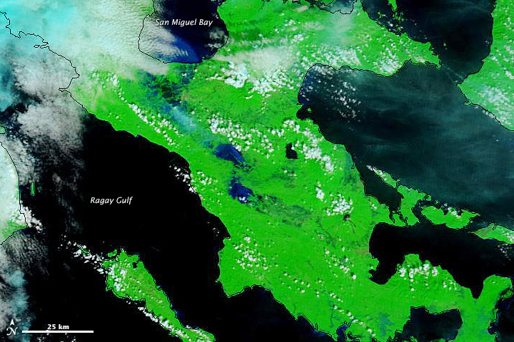 9 December, 2014
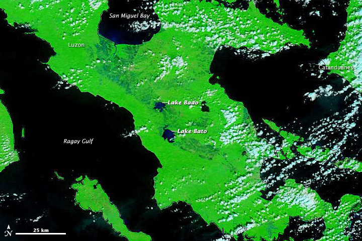 2 December, 2014 NASA Earth observatory
-
-
Aftermath of Malaysia worst ever floods. MODIS Data
31 December, 2014
13 December, 2014
Source of topographical map: commons.wikimedia.org map by Uwe Dedering
-
-
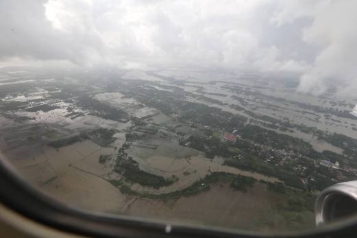
Southeast Asia floods 2014.
Malaysia fears third wave of worst-ever floods

‘Complete collapse’ in east coast flood response, NSC concedes. Source: kualalumpurpost.net
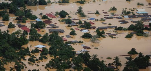
Photo taken on December 26 shows the situation in Kampung Manek Urai adversely affected by the floods. - Photo Fathil Asri. Source: bharian.com

Aerial view of Malaysia floods. hambaliabdullah.blogspot

REVIEW air in some areas around Kuala Krai are still flooded. Source: duniaitu.blogspot.ru
Important note: On satellite images is now a lot of clouds, so you can not see the "full picture" of floods in Malaysia. Satellite data MODIS
27 December, 2014
Normal
Source of topographical map: commons.wikimedia.org map by Uwe Dedering
30 December, 2014. ‘Complete collapse’ in east coast flood response, NSC concedes

 The National Security Council's (NSC) disaster management suffered a "complete collapse" at the district level in the peninsula's east coast, as its staff were among the hundreds of thousands beset by arguably the worst flooding in decades.
NSC secretary Datuk Mohamed Thajudeen Abdul Wahab was quoted by English daily The Star as saying that they were unable to execute their disaster management plan on the ground as their district level teams could not deploy.
"In the districts, the frontliners of our disaster management machinery include the village headman and district officers. But due to the magnitude of the floods, most districts were completely inundated. "Our entire district machinery collapsed as they had become victims themselves," he was quoted as saying in the report.
Thajudeen said they were severely disadvantaged during the peak of the floods between December 23 and 27, when it had been virtually "impossible" to access many areas, especially with the lack of communication as power was cut to avoid electrocution.
He said their biggest problem was figuring out where help was needed and the extent of the damage caused by the floods in each district, despite having managed to stockpile donations of food and supplies from the public and companies. "We could not use heavy vehicles; the currents were too strong to use boats and the winds were too turbulent to go by air," he said of the five-day period.
Thajudeen said the situation has become "slightly better" with the receding flood waters, allowing aid to be delivered by air and on the ground, but noted that there were still several areas where helicopters could not land. A total of five deaths were recorded in Kelantan, three in Pahang and two in Terengganu to date, according to data published by the NSC on its website.
As at 8am today, a total of 235,218 people have been evacuated from their homes in Terengganu, Kelantan, Pahang, Perak, Johor, Perlis, Selangor and Kedah.
Although floodwaters are gradually receding in Kuala Krai and Kota Baru, meteorologists have warned that the worst is not yet over in Kelantan, Pahang and Terengganu.
Reports continue to pour in on overcrowded shelters; intermittent communications services; shortage of food and water supply; rescue efforts hampered by power outages; and roads that have been washed away by the floods.
The extent of the worst flooding in decades has been such that Deputy Prime Minister Tan Sri Muhyiddin Yassin, who is overseeing the government’s flood relief efforts, has warned that floods are worse than anticipated, saying that assets currently deployed were inadequate to face the floods of such proportions. Source: themalaymailonline.com29 December, 2014. Floods in Malaysia and Thailand kill at least 24.
The worst flooding in Malaysia in more than a decade has killed 10 people and forced nearly 160,000 from their homes and more rain is expected, authorities said on Sunday.
Among the casualties, five were in the worst-hit state of Kelantan, in northeastern peninsular Malaysia. Over the border in southern Thailand, 14 people have been killed in the floods that began in mid-December.
Malaysian Prime Minister Najib Razak toured some of the worst-hit areas this weekend, following his return from a vacation in Hawaii on Friday. Najib was criticised for his absence during the calamity, after being photographed playing golf with President Barack Obama.
Northeastern Malaysia and southern Thailand are regularly hit by flooding during the annual northeast monsoon but this year the rain has been particularly heavy.
The Malaysian government said rain in Kelantan and southern Thailand would last for at least another week. An official in the southern Thai border town of Sungai Kolok said it would take up to two days for water levels to drop and for the border to be reopened Source: antaranews.com30 December, 2014. Malaysia death toll up to 10, fears of fresh flooding
Ten people have been killed in Malaysia's worst flooding for 30 years and over 219,000 displaced from their homes, local media reported on Tuesday (Dec 30), with residents worried about further inundation.
While the waters were beginning to recede on Tuesday, more bad weather was forecast over the next two days, with intermittent to heavy showers predicted for the northeastern states of Kelantan, Terengganu and Pahang. The region is regularly hit by flooding during the annual monsoon, between November and March, but this year's storms have been unusually powerful.
"In my 42 years of living in Kelantan, I have never witnessed such a storm and destruction," said Ee Su Chuong, 42, the owner of an auto repair shop in Kota Bharu in Kelantan - the worst-hit state. "But our fear is there could be another fresh round of flooding. We are certainly worried." Ee also said that electricity had not been fully restored in Kota Bharu.
As waters receded, images of overturned vehicles and victims returning to their homes to salvage their belongings were splashed across local newspapers. Another area badly affected by the storm is Kuala Krai district, also in Kelantan - one of Malaysia's poorest states - where thousands of homes are totally submerged. "I hope there isn't a third wave like people have been saying," Kuala Krai resident Maznah Abdul Rahman, 55, was quoted as saying by The Malay Mail.
Prime Minister Najib Razak - who has come under fire for what was seen as the government's slow response to the crisis - announced an additional 500 million ringgit (US$143 million) assistance after touring parts of Kelantan over the weekend. Najib also ordered all his cabinet ministers to return to work, cutting short their traditional year-end holidays to manage the flooding crisis.
Truck drivers have complained of diesel shortages as many petrol stations have been submerged. At relief centres, workers are struggling to cope with a lack of clean water and unsanitary conditions. The government has postponed the start of the school year by one week in light of the floods. Source: channelnewsasia.comSri Lanka
 Sri Lankan men stand on debris of damaged houses in Mathugama, on the outskirts of Colombo, Sri Lanka - AP. Source: khaleejtimes.com
30 December, 2014. 30 dead, 1 million hit by Sri Lanka floods
At least 30 people have died, six are missing and about a million more were affected by floods in Sri Lanka caused by non-stop rains since Friday, an official said Monday.
'At this moment, we have 30 dead and six missing, and we have 33,346 families displaced as a result of the rain in 626 localities,' Anthony Milroy of Sri Lanka's Disaster Management Centre said.
He said the heavy rainfall had subsided in the southern part of the country, but continued to pour down on the northeastern part, the region most affected by flood.
Milroy said about 100,000 people have been displaced by the rain and about a million have been otherwise affected, but he was unable to provide any details about relief efforts underway.
According to reports, several roads were blocked and communications were affected in practically the entire country.
Authorities have evacuated Mutur and Somapura, in Koddiyar Bay, in northeastern part of the country.
Sri Lanka commemorated Friday the 10th anniversary of the tsunami that devastated a considerable part of the country, leaving over 35,000 people dead and over another 5,000 missing. This year, the Sri Lankan government selected the theme 'Safety Sri Lanka -- let us unite to eradicate disasters' on National Safety Day, which has been an annual event held Dec 26 since 2006. Source: khaleejtimes.comPhilippines

This is an aerial view of Loboc town in Bohol, hit by heavy flooding in the aftermath of Seniang. Photo courtesy of the Philippine Army, Bohol Capitol, Edcom Bohol. Source: rappler.com
30 December, 2014. ‘Unprecedented’ floods in Bohol as Seniang kills 11
Bohol Governor Edgar Chatto says Loboc town experienced 'unprecedented flooding,' with residents unable to anticipate the water level rise. Two days of heavy flooding and landslides killed 11 people as tropical storm Seniang (Jangmi) crossed the Visayas on Tuesday, December 30, with water in some areas "neck deep," officials said.
Seniang, which was forecast to bring up to 15 millimeters (0.6 inches) of rain per hour, barreled through fishing and tourist areas on Tuesday, with about 1,700 people being evacuated ahead of its arrival.
Bohol is among the provinces hardest hit by floods, and is now under a state of calamity.
Five people were killed after a landslide buried a house in Tanauan town, Leyte province, the region's civil defense spokeswoman Blanche Gobenciong told Agence France-Presse (AFP). "We are focused on floods and landslides because, while the storm's winds are weak, it will bring heavy rain," national civil defense chief Alexander Pama told DZMM radio. An 8-year-old girl drowned after raging floodwaters washed away her family's shanty home in the coastal town of Ronda in Cebu province, regional civil defense officer Allen Cabaron told AFP, adding that 6 of the girl's housemates are missing.
Two teenage boys, meanwhile, died from electrocution while wading through floodwaters in Loon in Bohol province, Cabaron added.
Rivers burst their banks, covering roads and highways in knee-deep floods that washed out bridges and stalled vehicles, Cabaron said, adding that floods in some areas were "neck-deep.”
‘Unprecedented flooding in Bohol’. In an interview on ANC, Bohol Governor Edgar Chatto said heavy flooding hit Bohol, with the municipalities of Loboc and Maribojoc the focus of rescue and relief efforts.
“The water of the river rose to heights that are unprecedented. It’s been a long time since the [Loboc] river rose to this level, and maybe also [with] the high tide compounding the problem, the water was not able to exit the river. We are now sending choppers to towns to bring food items with the local disaster council,” Chatto said.
While residents were ordered to evacuate, Chatto said they did not expect the damage from the storm to be this devastating. “This is an unprecedented level. It has never happened for quite some time.” Source: rappler.com30 December, 2014. 'Seniang' kills 29, leaves 10 missing
Flash floods and landslides triggered by Tropical Storm Seniang (Jangmi) left at least 29 people dead and 10 missing, including in areas still recovering from last year's Typhoon Yolanda (Haiyan), officials said Tuesday.
Seniang, packing winds of 65 kilometers per hour (kph) and gusts of 80 kph, dumped heavy rains Monday on southern Mindanao, where floods destroyed bridges and highways, sending thousands of residents to evacuation centers. The storm then pushed its way through eastern and central islands, where most of the deaths occurred Tuesday. Source: sunstar.com.ph30 December, 2014. Floods, landslides kill at least 13 in Visayas, Mindanao; many more missing
Floods and landslides from torrential rains spawned by tropical storm "Seniang" have killed at least 13 persons, several of them children, since Monday, with many more still missing, various reports said.
At least seven of the fatalities, four of them children, were killed by landslides that struck Catbalogan City, Samar and Tanauan, Leyte Tuesday morning.
In Catbalogan, two children were confirmed dead in the landslide that struck Burak, Barangay Mercedes at 4 a.m. As of this posting, rescuers were scrambling to save an undetermined number of other persons who remain buried in the rubble, according to the city disaster rescue and rehabilitation office.
In Tanauan, Blanche Gobenciong, Region 8 director of the Office of Civil Defense, said at least five persons, including three members of a family -- two of them children -- were killed by a hundred-meter high landslide that buried at least five houses at the boundary of Barangays Cabuynan and Sto. Nino.
A fourth family member, a man who had been pinned down by huge rocks and fallen trees, was rescued and brought to a hospital in Tacloban City.
Catbalogan officials said at least 20 houses perched on hillsides were swept down the slopes towards the national highway by sliding earth they described as wide as a city block. Source: interaksyon.com
-
-
Malaysia worst-ever floods

Aerial view of residential areas and farms in Kelantan still flooded. - Photo by AFP, December 27, 2014. Source: themalaysianinsider.com
ZetaTalk: High Tide Excuses
Written January 22, 2011
This is not credible. How can people believe that floods can be predicted through March in the Philippines? The cover story on sinking is getting pretty thin. From the article at the link, at some point soon TPTB will have to come clean here. [and from another] http://www.google.com/hostednews/afp/article/ Hundreds of thousands of people already reeling from floods across the Philippines have been told to expect further heavy rains until March, as the disaster death toll rose to 53.
Rain has been overused by the establishment as an excuse for the obvious sinking. The establishment is now switching to high tides as an excuse, claiming that a storm surge is creating a high tide. Since the cause of a storm surge can be away from the shore, and not easily determined by the common man busy with his daily activities, this excuse is less easily challenged. The high tide or storm surge excuse will also move to tsunami, blaming a quake in some locale or another. But eventually, when the flood waters do not drain, the truth will out. Pakistan shows the process, as flooding in July was claimed to be slow draining due to continued rain up river, along the Indus River highlands. It was months later, almost half a year later, that it was acknowledged by NASA that the flood waters were not going to drain. The people on the ground, those affected, already knew this. It was not until the issue left the media, and those around the world would presume that the Pakistan floods had receded, that NASA made this admission.
The same process would occur in Indonesia, were it not for what is to soon follow. Our predictions were not just for the sinking of the plate tongue holding Indonesia. They were for islands in the Caribbean to disappear and Central America to be crushed. The locks at Panama are used for shipping worldwide, to bypass having to go around the tip of S America. This will not be out of the news, but will be a continuing subject due to the impact on business. The press does not, in fact, hold the public captive, like sheep, waiting to be told what to think! Look at commerce. Commerce involves a lot of face-to-face meetings and interaction. Phones are used, and cannot be blocked as commerce would likely halt then. The same is true of the Internet, which is used by universities, defence departments, and especially commerce to an immense degree. How do you stop people from talking? How do you stop awareness of the Straits of Gibraltar spreading by 125 miles and Africa moving 50 miles further east?
So of course plate movement will have to be admitted, and to the degree that our predictions are associated with this people will discover ZetaTalk, even without the assistance of the Puppet Master's determination to inform the public and encourage the formation of strong survival communities. We have stated that the establishment will become shrill in attacking our message, and ourselves as the source, as the truth of our predictions comes to light. Look at the past 15 years, since ZetaTalk began. Alternate emissaries or spokespersons have been pushed upon the public, though were not accepted. NASA associates were given the stage to pronounce our theories to be hogwash, and as long as NASA has a modicum of respect this will continue. The Earth changes have been blamed on the Sun, even when the Sun did not cooperate, or on some mythical galactic alignment. The noise level will increase, so that the public increasingly sets about discerning the truth for themselves. ZetaTalk aligns with the facts, and has the track record, and thus will emerge the winner in this war28 December, 2014. Combination of natural phenomena contributed to floods, say climatologists
Adverse weather conditions resulting from a combination of the year-end monsoon, perigean spring tide and the La Nina phenomenon contributed to the worse-than-usual floods in northeastern Peninsular Malaysia which have displaced more than 160,000 people, said climatologists.
A perigean spring tide is a tide that occurs three or four times a year when the moon's perigee (its closest point to Earth during its 28-day elliptical orbit) coincides with a spring tide (when the Earth, sun and moon are nearly aligned every two weeks).
This is worsened by the current Northeast monsoon experienced by the east coast, where northeasterly winds bring moist air, causing parts of the country to experience four to seven days of continuous heavy rainfall.
"This is an exceptional phenomenon. The gravitational pull of the moon causes high tides which prevent waters from the rivers to flow into the sea.
"As a result, the water has no way to go but overflow its banks, which inundated low- lying areas like Kuantan, Kota Baru and Kuala Terengganu," said climatologist Professor Datuk Dr Shaharuddin Ahmad from Universiti Kebangsaan Malaysia, citing the main towns of the three worst-hit states.
The Malaysian Meteorological Department had said the moon was closest to the Earth at 12.44am on Christmas Day, where it was as close as 364,791km from Earth, appearing as a super moon, or a larger than usual moon, even to casual observers. Climatologist Dr Ramzah Dambul from Universiti Sabah Malaysia, who is planning a trip to the affected areas as part of his research, did not discount the possibility that the La Nina phenomenon was a contributing factor as it usually brings severe thunderstorms.
He said the La Nina, coupled with the on-going monsoon, could have resulted in the worse than normal floods usually experienced by the states of Kelantan, Terengganu and some parts of Pahang.
"What we are probably seeing is the combined wind circulation from the two weather patterns which brings with it a lot of rain," he said.
Environmental Management & Research Association of Malaysia president Ellias Saidin, however, discounted overdevelopment as the cause of the floods, saying that the three states were not as developed as the western part of the peninsula. He said climate change which brought more rainfall and higher temperatures in the past few years could be one of the factors that contributed to the current situation.
"There are solutions to this, like flood mitigation projects, but it will be very expensive because it involves hundreds of kilometres of coastline and may involve relocation of people and animals as well," he said. The situation in Kelantan, Terengganu, Pahang, Johor and Perak is reportedly worsening, while the northern states of Perlis and Kedah reported that the flood situation has improved.
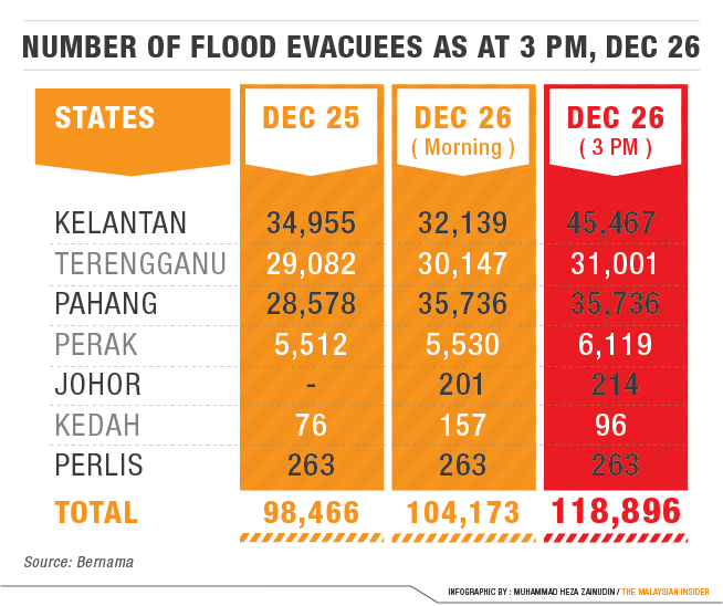
In Kelantan, as of yesterday, 81,925 evacuees were in relief centres, up from the 45,467 on Friday night, national news agency Bernama reported.
The total number of evacuees nationwide rose to more than 160,000 yesterday.
Rescue teams were reported to be struggling to reach inundated areas of northeast Malaysia as victims accused the government of being slow to provide assistance after the country's worst flooding in decades. Deputy Prime Minister Muhyiddin Yassin admitted rescuers were facing challenges with power outages and roads washed away by the floods. "I admit the situation is challenging to the rescue workers and we are trying our best to make sure that the food arrives to the victims depending on the flood situation," he was quoted as saying by The Star.
Prime Minister Datuk Seri Najib Razak who was severely criticised for playing golf in Hawaii with US president Barack Obama while parts of the country were under water, returned yesterday and went straight to Kelantan where he was briefed on the flood situation by the National Security Council before visiting some of the affected areas. – December 28, 2014. Source: themalaysianinsider.com This aerial view shows houses and plantations submerged in flood waters in Pengkalan Chepa, near Kota Bharu in Malaysia. (AFP PHOTO / MOHD RASFAN)
 Prime Minister Datuk Seri Najib Razak is scheduled to visit Kelantan today to have a first-hand look at the flood situation there. – AFP pic, December 27, 2014.
An aerial view of flooded streets of the National Park in Kuala Tahan, Pahang December 24, 2014. Credit: Reuters/Nazirul Roselan. Source: uk.reuters.com
An aerial view of the flood situation worsens around Bandar Kota Baru due to overflow from Sungai Kelantan on Saturday. Source: politikputramerdeka.blogspot.ru
 Images captured by the crew AW139 Fire Air Unit vicinity of Manik Urai Lama today. Source: facebook.com
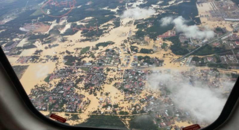.jpeg) Aerial view of Gambar. Source: theotherkhairul.blogspot.ru
Aerial view of Gambar. Source: theotherkhairul.blogspot.ru
A resident checking out his flooded house. Experts say a number of factors contributed to the floods in Kelantan and several other states. – AFP pic, December 28, 2014. Source: themalaysianinsider.com

The Malaysian Armed Forces will review its standard operating procedure in disaster management following severe floods that have struck the nation. — TRP pic by Mokhsin Zamani. Source: therakyatpost.com
 This aerial view shows houses submerged in floodwaters in Pengkalan Chepa, near Kota Bharu on Dec. 27, 2014. (AFP PHOTO/MOHD RASFAN). Source: torontosun.com
27 December, 2014. Number of Malaysians displaced by worst-ever floods reaches 160,000
The number of people evacuated due to Malaysia's worst-ever floods jumped to more than 160,000 on Saturday, as Prime Minister Najib Razak reached the worst-hit state after cutting short a vacation in the U.S.
Najib arrived in Kelantan, which has the biggest problems among eight affected states, following his return from Hawaii on Friday after public criticism he had been absent as flooding worsened.
On Saturday, Najib announced an additional 500 million ringgit ($143.31 million) will be spent to aid victims after the flood subsides, following an initial government allocation of 50 million ringgit two days ago.
The number of people evacuated topped 160,000 at 0700GMT Saturday, according to the New Straits Times newspaper, a sharp increase from 100,000 a day before. The prime minister attended briefings with the National Security Council, the National Disaster Management and Relief Committee, state government and local emergency responders, a statement on Friday said.
Northeastern peninsular Malaysia, which is worst affected part of the country, is regularly hit by flooding during the annual "northeast monsoon", but this year's rains have been particularly heavy. Source: in.reuters.com
-
-
Malaysia
103,000 evacuated in record-breaking Malaysia floods. Source: bharian.com
http://translate.google.com/translate?hl=en&sl=auto&tl=en&a...
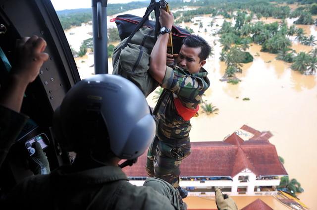
Reduce military aid from a helicopter by means of 'winching' to Sek Keb Manek Urai hit. Source: bernama.com
http://translate.google.com/translate?hl=en&sl=auto&tl=en&a...
 The scenery from the air Bandar Kota Baharu filled with water due to the overflow of Sungai Kelantan today. Source: twitter.com
An aerial view of Kuala Krai town. Source: nst.com.my

Aerial view Kelantan. Source: twitter.com

The situation in Manek Urai, Kelantan. It was reported that the water level in Sungai Kelantan exceeded the danger level at Tangga Krai, Jambatan Guillemard and Tambatan Diraja. — Bernama pic. Source: therakyatpost.com

Some of the people who were rescued from Gunung Gagau are seen arriving on a boat at Hulu Terengganu on December 22, 2014. — Bernama pic. Source: themalaymailonline.com

The floods in the east coast, Perlis and Perak have displaced more than 100,000 victims to date and are said to be the worst in the country's history. Source: news.asiaone.com
26 December, 2014. Terengganu hit by worst floods in three decades
 About 80 per cent of villages in Hulu Dungun have been flooded since the first wave of floods on December 15 when Sungai Dungun overflowed due to the high tide phenomenon.
The floods, which inundated 20 villages in Bukit Besi state constituency, are regarded by residents as the worst since 1983.
Among the affected villages are Kampung Kuala Jengai, Kampung Rantau Panjang, Kampung Dendang, Kampung Jerangau Sungai, Kampung Minda, Kampung Shukor, Kampung Padang Ping and Kampung Lintang.
“This time, the floods are very bad. Since my village is flooded every year, I keep my valuable items on a raft,” he said when met by Bernama. Zulfadzli Supaat, 42, and Siti Salmiah Sikh Salim, 41, of Kampung Wa experienced harrowing moments when water entered their home at midnight. Teacher Zulfadzli had to call friends to help evacuate his teacher wife and their 45-day-old baby.
“It was a really anxious moment. The only thing on my mind was to evacuate my wife and baby. Thank god, both of them are safe. “This is the worst flood in my 14-year stay here. During past floods, the water only rose to my calf but this time it came up to my waist,” he said.
For senior citizen Mat Jais Jah, 84, the floods inundating his village this time reminded him of the one 31 years ago.
“The floods in 1983 were bad but this time it is worse as more people are evacuated. Fortunately, we have comfortable relief centres and food. Thank god, now all is provided by the government. “In 1983, we had to escape to hill tops in the village or squatted at houses of villagers built on high ground.
Meanwhile, chairman of Kampung Jerangau Sungai Development and Security Committee chairman Mohamad Jusoh, said more people were evacuated in the floods compared to previous years. Source: themalaymailonline.com26 December, 2014. Parts of Kuala Lumpur hit by flash floods

Flood in Kota Baru, Kelantan.
A two-hour downpour caused the overflowing of Sungai Gombak, which spilled into the city centre.
"We received reports at 10.48pm that there was a flash flood in Jalan Pekeliling and at 11.10pm, we were informed that Jalan Tun Razak heading to Jalan Ipoh was also affected," a Federal Territories Civil Defence Department (JPAM) source said when contacted.
"However, the flood subsided after about one hour," the source added.
The flash floods also caused a traffic standstill at Jalan Pahang at midnight as some parts of the road were submerged in water.
Kuala Lumpur City Hall's Integrated Transport Information System (ItisDBKL) said Friday morning that the city has been cleared from any flood.
Social media was abuzz with photos from last night's flash flood, raising concern among netizens amid worsening floods in the east cost, Perlis and Perak.
More than 100,000 victims have been evacuated following the floods there, deemed to be worst in the country's history.26 December, 2014. 103,000 evacuated in record-breaking Malaysia floods
More than 103,000 people have been evacuated due to flooding in four states in peninsular Malaysia during the heaviest rainy season downpour in decades.
Pahang state experienced the largest increase in the number of evacuees, as an additional 6,000 displaced persons brought the total to more than 35,700 on Friday, according to the Malaysian Insider news website. Of the displaced, nearly 20,000 are currently sheltered at 44 relief centers in the state capital of Kuantan.
In Kelantan, the number of evacuees decreased slightly from almost 35,000 to around 32,000 as six districts experienced an improvement in the flooding situation.
More people were also displaced in Terengganu and Perak, bringing the total evacuees in the states to more than 30,000 and 5,500, respectively.
Meanwhile, New Years celebrations have been canceled in Perak and Putrajaya city, Malaysia’s federal administrative center south of capital Kuala Lumpur.
Meanwhile, the cancelation of programs in Putrajaya was announced by the federal territories minister, who defended Prime Minister Najib Razak against criticism for being abroad as the country deals with the worst floods in four decades.
"Some say PM does not bother, ministers don't bother... all this is propaganda and slander," the Insider quoted Tengku Adnan Tengku Mansor as saying at a press conference at the ministry's Christmas open house Thursday. Source: worldbulletin.net26 December, 2014. PM under fire as 118,000 flee worst Malaysia floods in decades
Malaysia's worst flooding in decades forced some 118,000 people to flee as premier Najib Razak came under fire after photos showed him golfing with US President Barack Obama during the storms. Source: dailymail.co.uk
-
Comment by Khan on December 26, 2014 at 3:24am
-
In Jakarta, that sinking feeling is all too real-sunk 13 feet (4 meters) over the past three decades
Dec 23, 2014
A view of a section of the new seawall being constructed next to the existing one (R) in Muara Baru, north Jakarta, Sept. 30, 2014. REUTERS/Darren Whiteside
JAKARTA, Dec 22 (Reuters) - The Ciliwung River flows from a volcano south of the Indonesian capital, through the heart of one of the world's most densely populated cities and almost into Jakarta Bay. Almost, because for the final mile or so of its course, the river would have to flow uphill to reach the bay.
The same is true for the rest of the half-dozen sewage-choked rivers that wind though central Jakarta. Unable to defy gravity, they've been redirected to canals that drain into the sea.
The reason these conduits are necessary is that Greater Jakarta, an agglomeration of 28 million people, sits on a swampy plain that has sunk 13 feet (4 meters) over the past three decades.
"Jakarta is a bowl, and the bowl is sinking," said Fook Chuan Eng, senior water and sanitation specialist with the World Bank, who oversees a $189 million flood mitigation project for the city.
The channels of the Ciliwung and other rivers are sinking. The entire sprawl of Jakarta's north coast - fishing ports, boatyards, markets, warehouses, fish farms, crowded slums and exclusive gated communities - it's all sinking. Even the 40-year-old seawall that is supposed to keep the Java Sea from inundating the Indonesian capital is sinking.
Just inside the seawall sits the Muara Baru kampong, or village, that is home to more than 100,000 people. It is now at least 6 feet below sea level, and residents like Rahmawati, a mother of two small children, gaze upward from their front stoops to view the sea.
"When there's a high tide, the ships float almost at the same height as the seawall - we can see the ships from here," said Rahmawati, who like many Indonesians goes by one name.
Flooding from overflowing rivers and canals in the area is at least an annual event that forces Rahmawati and the rest of the kampong to evacuate to public buildings nearby. High-water marks from the last big flood, in 2013, are still visible on the walls of the kampong.
-
Comment by casey a on December 25, 2014 at 7:45pm
-
yup.. but i suspect these south east asian leaders are panicking about painting themselves into a corner. As long as the announcement doesn't take place & the flooding continues to gets worse, they'll be forced to lie to their people. And the longer they lie, the more likely their people will get mad at them later.
© 2024 Created by 0nin2migqvl32.
Powered by
![]()
You need to be a member of Earth Changes and the Pole Shift to add comments!
Join Earth Changes and the Pole Shift