Wild Weather, the Wobble Effect
|
Weather: |
Tides and Whirlpools:
|
"We warned at the start of ZetaTalk, in 1995, that unpredictable weather extremes, switching about from drought to deluge, would occur and increase on a lineal basis up until the pole shift. Where this occurred steadily, it has only recently become undeniable. ZetaTalk, and only ZetaTalk, warned of these weather changes, at that early date. Our early warnings spoke to the issue of global heating from the core outward, hardly Global Warming, a surface or atmospheric issue, but caused by consternation in the core. Affected by the approach of Planet X, which was by then starting to zoom rapidly toward the inner solar system for its periodic passage, the core was churning, melting the permafrost and glaciers and riling up volcanoes. When the passage did not occur as expected in 2003 because Planet X had stalled in the inner solar system, we explained the increasing weather irregularities in the context of the global wobble that had ensued - weather wobbles where the Earth is suddenly forced under air masses, churning them. This evolved by 2005 into a looping jet stream, loops breaking away and turning like a tornado to affect the air masses underneath. Meanwhile, on Planet Earth, droughts had become more intractable and deluges positively frightening, temperature swings bringing snow in summer in the tropics and searing heat in Artic regions, with the violence of storms increasing in number and ferocity."
From the ZetaTalk Chat Q&A for February 4, 2012:
The wobble seems to have changed, as the temperature in Europe suddenly plunged after being like an early Spring, Alaska has its coldest temps ever while the US and much of Canada is having an extremely mild winter. India went from fatal cold spell to balmy again. Has the Earth changed position vs a vs Planet X to cause this? [and from another] Bitter cold records broken in Alaska - all time coldest record nearly broken, but Murphy's Law intervenes [Jan 30] http://wattsupwiththat.com/2012/01/30/bitter-cold-records-broken-in-alaska Jim River, AK closed in on the all time record coldest temperature of -80°F set in 1971, which is not only the Alaska all-time record, but the record for the entire United States. Unfortunately, it seems the battery died in the weather station just at the critical moment. While the continental USA has a mild winter and has set a number of high temperature records in the last week and pundits ponder whether they will be blaming the dreaded "global warming" for those temperatures, Alaska and Canada have been suffering through some of the coldest temperatures on record during the last week.

There has been no change in the wobble pattern, the wobble has merely become more severe. Nancy noted a Figure 8 format when the Earth wobble first became noticeable, in early 2005, after Planet X moved into the inner solar system at the end of 2003. The Figure 8 shifted along to the east a bit on the globe between 2005 and 2009, (the last time Nancy took its measure) as Planet X came closer to the Earth, encountering the magnetic N Pole with a violent push earlier in the day. But the pattern of the Figure 8 remained essentially the same. So what changed recently that the weather patterns became noticeably different in late January, 2012?
The N Pole is pushed away when it comes over the horizon, when the noon Sun is centered over the Pacific. This regularly puts Alaska under colder air, with less sunlight, and thus the historically low temps there this January, 2012 as the wobble has gotten stronger. But by the time the Sun is positioned over India, the N Pole has swung during the Figure 8 so the globe tilts, and this tilt is visible in the weather maps from Asia. The tilt has forced the globe under the hot air closer to the Equator, warming the land along a discernable tilt demarcation line.
The next loop of the Figure 8 swings the globe so that the N Pole moves in the other direction, putting the globe again at a tilt but this time in the other direction. This tilt is discernable in weather maps of Europe, again along a diagonal line. Depending upon air pressure and temperature differences, the weather on either side of this diagonal line may be suddenly warm or suddenly cold. The tilt and diagonal line lingers to affect much of the US and Canada, but the Figure 8 changes at this point to be an up and down motion, pulling the geographic N Pole south so the US is experiencing a warmer than expected winter under a stronger Sun. Then the cycle repeats, with the magnetic N Pole of Earth pushed violently away again as the Sun is positioned over the Pacific.
From the ZetaTalk Chat Q&A for April 6, 2013:
Would the Zetas be able to let us know what is causing the early break-up of the Arctic Ice, the ice seems to have taken on a swirling pattern at the same time, would this be wobble related? [and from another] http://www.vancouversun.com/news/national/Canada+Arctic+cracks+spec... The ice in Canada’s western Arctic ripped open in a massive “fracturing event” this spring that spread like a wave across 1,000 kilometres of the Beaufort Sea. Huge leads of water – some more than 500 kilometres long and as much as 70 kilometres across – opened up from Alaska to Canada’s Arctic islands as the massive ice sheet cracked as it was pushed around by strong winds and currents. It took just seven days for the fractures to progress across the entire area from west to east. [and from another] http://earthobservatory.nasa.gov/IOTD/view.php?id=80752&src=iot... A high-pressure weather system was parked over the region, producing warmer temperatures and winds that flowed in a southwesterly direction. That fueled the Beaufort Gyre, a wind-driven ocean current that flows clockwise. The gyre was the key force pulling pieces of ice west past Point Barrow, the northern nub of Alaska that protrudes into the Beaufort Sea.

The Figure 8 formed by the N Pole during the daily Earth wobble has shifted somewhat to the East, due to Planet X positioned more to the right of the Earth during its approach. This was anticipated, and well described in ZetaTalk, the Earth crowding to the left in the cup to escape the approach of Planet X, so the angle between these two planets would change slightly. This shift of the Figure 8 to the East is due to the push against the Earth’s magnetic N Pole occurring sooner each day than prior. Thus instead of occurring when the Sun is high over the Pacific, over New Zealand, it is now occurring when the Sun is high over Alaska. All the wobble points have shifted eastward accordingly.
This has brought a lingering Winter to the western US, and a changed sloshing pattern to the Arctic waters. Instead of Pacific waters being pushed through the Bering Straits into the Arctic when the polar push occurs, the wobble is swinging the Arctic to the right, and then later to the left, creating a circular motion in the waters trapped in the Arctic. Since the Earth rotates counterclockwise, the motion also takes this path. This is yet another piece of evidence that the establishment is hard pressed to explain. They are attempting to ascribe this to high pressure and wind, all of which are not new to the Arctic, but this circular early breakup of ice in the Arctic is new.
Views: 630669
Comment
-
Comment by Derrick Johnson on April 2, 2013 at 8:27am
-
Statewide snowpack at half of normal levels
With the statewide snowpack at only 52% of the norm for this time of year, state and federal water managers are expecting below-normal spring runoff and falling reservoir levels.
The last three months in California have been the driest of any January-through-March period on record, going back to 1895.
It has been a winter of extremes in the state, beginning with an unusually wet November and December and ending with a string of parched months.
Storage in the state’s two largest reservoirs, Shasta Lake and Lake Oroville, is a bit above normal for the date, thanks to the big storms in the Northern Sierra that turned the final three months of last year into the 10th-wettest on record for that region.
But that cushion is expected to disappear in the coming months. Although no one is declaring drought, the state last week cut projected water deliveries to Southern California.
Read more: http://fox5sandiego.com/2013/03/29/statewide-snowpack-at-half-of-no...
-
-
Driest First Quarter of Year on Record for Much of California
There was no ‘miracle March’ for rain lovers in California this year following an exceptionally dry January and February. The dry weather continued through March resulting in the driest first three months of the year on record for San Francisco and other sites across the state.
San Francisco received a March total of .96” with half this amount falling on the last day of the month (Sunday March 31st). This brought the 3-month total (since January 1st) to 2.30”, just 19% of normal (normal amount for the period is 12.22”) and is thus the driest such period since precipitation records began in the fall of 1849. The previous driest Jan-March period was in 1851 when 3.20” was measured. The next (now 3rd) driest was during the great drought of 1975-1977 when only 3.31” was recorded in Jan-March 1976. It is quite astonishing to see the huge margin between this year’s driest ever Jan-March (2.30”) and the previous such record of 3.20” in 1851: a full 30%, and this for a site with 163 years of record.
Across the Bay from San Francisco, Oakland was even drier (it missed, for instance, the isolated rain cell that dropped heavy rain (.48”) on San Francisco yesterday. The January-March total for Oakland has been a meager 1.30” (JAN: .29”, FEB: .52”, MAR: .49”). The monthly totals in San Francisco were JAN: .49”, FEB: .85”, MAR: .96”. Oakland’s normal Jan-March rainfall is 12.60” so this year is running just 10% of normal at this time.
Here are some of the three-month totals (January-March 2013) for other sites in the San Francisco Bay Area and northern California (listed from north to south):
-
-
Weather: Coldest Easter and no respite in sight
Published on Monday 1 April 2013 00:00SCOTLAND endured the coldest Easter Day on record yesterday – with –12.5C recorded on Royal Deeside.
The temperature shattered the previous record of –9.8C on Easter Monday 1986.
And weathermen warn that high pressure sitting to the north of the UK will continue to bring cold conditions until next weekend.
The honour of the record-breaking low fell to Braemar between Saturday night and Sunday morning. It followed another freezing night on Friday, when –11C (12F) was recorded in the same area.
Lying snow and light winds were blamed for creating the ice-box conditions.
Overall, this March has been provisionally declared the coldest in 50 years. A spokesman for the Met Office in Aberdeen said: ”Frost and low temperatures are not uncommon at this time of the year. What is unique about this Easter is this extreme low temperature recorded on Sunday morning – it’s unique.”
Families heading out for a walk on Easter Day experienced some of the chilliest conditions for years, though daytime temperatures are predicted to rise into April.
Towns and cities across Scotland were last night down to –3C and –4C (25-27F).
The Met Office spokesman added: “You could say things are fairly settled – remaining cold and frosty at night, but with things warming up during the day. There will be the odd snow flurry on the east coast, but, effectively, high pressure is guaranteeing no change for the forseeable future.”
Thousands of families jetted off for sunnier climes last Thursday and Friday, but many would have found the surprise Easter weather extended into Europe’s traditional hot-spots, forecasters also warned.
-
Comment by Yvonne Lawson on March 31, 2013 at 9:40am
-
Spring: Where has it gone?
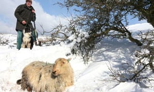
This week, violent easterly winds and drifting snow made a mockery of spring, and battered the most resilient living things in Britain.
A "wreck" of more than 500 puffins occurred on eastern Scotland, the biggest mass fatality since 1947. Welsh mountain sheep, and other equally hardy breeds, have been smothered by Easter snowdrifts on high ground from Snowdonia to the Isle of Man that recall the gruesome winter of 1963. And a week of digging into 35ft snowdrifts in search of lambing ewes has brought tears to the eyes of the hardiest farmers
http://www.guardian.co.uk/environment/2013/mar/30/spring-where-has-...
-
-
Huge spring tide floods south bank of the Thames
Plans for traditional Easter egg hunts and family walks will have to be put on hold tomorrow as the UK prepares itself for yet another chilly day.
The elusive spring weather will once again be eclipsed by low temperatures, although forecasters predict that the sun will make an appearance.
After what is thought to be the coldest March in decades, the Bank Holiday weekend will also be accompanied by temperatures up to four degrees lower than the seasonal average.
http://www.dailymail.co.uk/news/article-2301473/UK-weather-Youre-go...
-
Comment by lonne rey on March 30, 2013 at 11:51am
-
Lambs get woolly jumpers to survive -10°C Easter
SHIVERING sheep are being given woolly jumpers to help them survive as Britain faces its coldest Easter on record — with temperatures of -10°C.
Farmers were still digging livestock out of snow drifts yesterday and fear at least 10,000 sheep may have died.
The current icy blast has struck in the middle of lambing season, putting newborns at even greater risk.
-
-
White Easter: Germany Faces Coldest March Since 1883
Complaining about the weather has reached epidemic proportions in northern Germany this "spring." And with good reason. With Easter just around the corner, meteorologists are telling us this could end up being the coldest March in Berlin and its surroundings since records began in the 1880s.
March set to be coldest in UK since 1962
Mean temperature for the month so far is 2.5C (36.5F) – three degrees below long-term average
The coldest March in the UK was in 1962, at 1.9C (35.4F), followed by 1947, 2.2C (35.9F), 1937, 2.4C (36.3F), and 1916 and 1917, 2.5C (36.5F).
Coldest Easter since 1964 (The Netherlands)
In 1964 the maximum temperature was on Easter Sunday at 3.9 degrees above zero
March 2013 is in the top 10 coldest months ever in March. The average temperature is 2.6 degrees, normally it would be in March averaged 6.2 degrees should be. Especially the latter part of March is cold.
-
Comment by Sevan Makaracı on March 27, 2013 at 8:54pm
-
Snowstorm spares Chicago, may be the last of unusual winter
The snowstorm that buried central and southern Illinois on Sunday only skirted Chicago as it headed east - carrying with it maybe the last of an unusual winter that it seemed would never end. The storm dropped 17 inches of snow in Springfield, demolishing the old record of 2.4 inches for March 24 set in 1947. The University of Illinois at Urbana-Champaign canceled Monday classes because students had trouble getting back to campus after spring break, according to the National Weather Service. Roads remained hazardous south of Chicago, according to the Illinois Department of Transportation. Stretches of interstates 55, 57 and 70 were reported covered in ice or snow through central Illinois. In the Chicago area, snowfall totals were more in the 1- to 3-inch range, National Weather Service meteorologist Amy Seeley said.
"We've got temperatures in the mid-50s for Saturday and Sunday. That's not so bad," said Seeley, who indicated there was a chance for rain Saturday night and Sunday as well. The Chicago Weather Center said the weekend storm is likely the last significant storm of a winter that saved its punch for February and March instead of December and January. With temperatures expected to rise into the 50s by the weekend, the string of consecutive days of below-normal temperatures may come to an end. The long-term forecast may be a little less positive: temperatures below average and precipitation above average over the next eight to 14 days, WGN-TV meteorologist Tim McGill said. But things are looking up for mid-April, with the possibility of some temperatures above normal. According to the National Weather Service's Climate Prediction Center, the Chicago area should see above-normal temperatures for April, May and June, Seeley said. The average for April is 48.9 degrees. Above-normal precipitation is also expected, she said.
-
-
Big freeze to grip Britain until the end of April say forecasters after jet stream which brings us mild air dips down to Africa
- Jet stream has been pushed to unusually southerly location
- Band of high pressure has stopped the belt of wind from moving
- Jet stream cannot push in milder weather conditions from the west
- Bitterly cold conditions expected to remain throughout April
-
-
What a difference a year makes: As Britain endures its coldest March since 1963, just 12 months ago we were basking in sunniest March since 1929
As our pictures show, then sunseekers flocked to beaches, and even northern Scotland enjoyed temperatures exceeding 22C.
Yesterday it peaked at 2C amid the snow. Whatever will the climate deal us next?
Read more: http://www.dailymail.co.uk/news/article-2298255/UK-weather-What-dif...
© 2025 Created by 0nin2migqvl32.
Powered by
![]()
You need to be a member of Earth Changes and the Pole Shift to add comments!
Join Earth Changes and the Pole Shift