"We warned at the start of ZetaTalk, in 1995, thatunpredictable weather extremes, switching about from drought to deluge,would occur and increase on a lineal basis up until the pole shift. Where this occurred steadily, it has only recently become undeniable. ZetaTalk, and only ZetaTalk, warned of these weather changes, at that early date. Our early warnings spoke to the issue of global heating from the core outward, hardly Global Warming, a surface or atmospheric issue, but caused by consternation in the core. Affected by the approach of Planet X, which was by then starting to zoom rapidly toward the inner solar system for its periodic passage, the core was churning, melting the permafrost and glaciers and riling up volcanoes. When the passage did not occur as expected in 2003 because Planet X had stalled in the inner solar system, we explained the increasing weather irregularities in the context of the global wobble that had ensued - weather wobbles where the Earth is suddenly forced under air masses, churning them. This evolved by 2005 into a looping jet stream, loops breaking away and turning like a tornado to affect the air masses underneath. Meanwhile, on Planet Earth, droughts had become more intractable and deluges positively frightening, temperature swings bringing snow in summer in the tropics and searing heat in Artic regions, with the violence of storms increasing in number and ferocity."
The wobble seems to have changed, as the temperature in Europe suddenly plunged after being like an early Spring, Alaska has its coldest temps ever while the US and much of Canada is having an extremely mild winter. India went from fatal cold spell to balmy again. Has the Earth changed position vs a vs Planet X to cause this?[and from another]Bitter cold records broken in Alaska - all time coldest record nearly broken, but Murphy's Law intervenes[Jan 30]http://wattsupwiththat.com/2012/01/30/bitter-cold-records-broken-in-alaskaJim River, AK closed in on the all time record coldest temperature of -80°F set in 1971, which is not only the Alaska all-time record, but the record for the entire United States. Unfortunately, it seems the battery died in the weather station just at the critical moment. While the continental USA has a mild winter and has set a number of high temperature records in the last week and pundits ponder whether they will be blaming the dreaded "global warming" for those temperatures, Alaska and Canada have been suffering through some of the coldest temperatures on record during the last week.
There has been no change in the wobble pattern, the wobble has merely become more severe. Nancy noted a Figure 8 format when the Earth wobble first became noticeable, in early 2005, after Planet X moved into the inner solar system at the end of 2003. The Figure 8 shifted along to the east a bit on the globe between 2005 and 2009, (the last time Nancy took its measure) as Planet X came closer to the Earth, encountering the magnetic N Pole with a violent push earlier in the day. But the pattern of the Figure 8 remained essentially the same. So what changed recently that the weather patterns became noticeably different in late January, 2012?
The N Pole is pushed away when it comes over the horizon, when the noon Sun is centered over the Pacific. This regularly puts Alaska under colder air, with less sunlight, and thus the historically low temps there this January, 2012 as the wobble has gotten stronger. But by the time the Sun is positioned over India, the N Pole has swung during the Figure 8 so the globe tilts, and this tilt is visible in the weather maps from Asia. The tilt has forced the globe under the hot air closer to the Equator, warming the land along a discernable tilt demarcation line.
The next loop of the Figure 8 swings the globe so that the N Pole moves in the other direction, putting the globe again at a tilt but this time in the other direction. This tilt is discernable in weather maps of Europe, again along a diagonal line. Depending upon air pressure and temperature differences, the weather on either side of this diagonal line may be suddenly warm or suddenly cold. The tilt and diagonal line lingers to affect much of the US and Canada, but the Figure 8 changes at this point to be an up and down motion, pulling the geographic N Pole south so the US is experiencing a warmer than expected winter under a stronger Sun. Then the cycle repeats, with the magnetic N Pole of Earth pushed violently away again as the Sun is positioned over the Pacific.
Would the Zetas be able to let us know what is causing the early break-up of the Arctic Ice, the ice seems to have taken on a swirling pattern at the same time, would this be wobble related?[and from another]http://www.vancouversun.com/news/national/Canada+Arctic+cracks+spec... The ice in Canada’s western Arctic ripped open in a massive “fracturing event” this spring that spread like a wave across 1,000 kilometres of the Beaufort Sea. Huge leads of water – some more than 500 kilometres long and as much as 70 kilometres across – opened up from Alaska to Canada’s Arctic islands as the massive ice sheet cracked as it was pushed around by strong winds and currents. It took just seven days for the fractures to progress across the entire area from west to east.[and from another]http://earthobservatory.nasa.gov/IOTD/view.php?id=80752&src=iot... A high-pressure weather system was parked over the region, producing warmer temperatures and winds that flowed in a southwesterly direction. That fueled the Beaufort Gyre, a wind-driven ocean current that flows clockwise. The gyre was the key force pulling pieces of ice west past Point Barrow, the northern nub of Alaska that protrudes into the Beaufort Sea.
The Figure 8 formed by the N Pole during the daily Earth wobble has shifted somewhat to the East, due to Planet X positioned more to the right of the Earth during its approach. This was anticipated, and well described in ZetaTalk, the Earth crowding to the left in the cup to escape the approach of Planet X, so the angle between these two planets would change slightly. This shift of the Figure 8 to the East is due to the push against the Earth’s magnetic N Pole occurring sooner each day than prior. Thus instead of occurring when the Sun is high over the Pacific, over New Zealand, it is now occurring when the Sun is high over Alaska. All the wobble points have shifted eastward accordingly.
This has brought a lingering Winter to the western US, and a changed sloshing pattern to the Arctic waters. Instead of Pacific waters being pushed through the Bering Straits into the Arctic when the polar push occurs, the wobble is swinging the Arctic to the right, and then later to the left, creating a circular motion in the waters trapped in the Arctic. Since the Earth rotates counterclockwise, the motion also takes this path. This is yet another piece of evidence that the establishment is hard pressed to explain. They are attempting to ascribe this to high pressure and wind, all of which are not new to the Arctic, but this circular early breakup of ice in the Arctic is new.
Comment by Gerard Zwaan on September 24, 2021 at 8:06am
Torrential downpours hit parts of southern Spain on September 23, 2021, causing severe flash flooding in the province of Huelva.
The floods inundated homes and swept away vehicles in the cities of Huelva and Lepe, and caused more than 600 emergency interventions.
According to the Andalusian Meteorological Agency, parts of the province received as much as 100 mm (4 inches) of rain in a 12-hour period on September 23.
Keep an eye on Larry, a strong Cat 4 monster. If the wobble causes it to head inland it would be a direct hit to DC, Philly, NYC and East Coast! Here are the 5 PM AST Saturday, September 4 Key Messages for Hurricane #Larry. Larry could bring a risk of strong winds, heavy rainfall, and coastal flooding to Bermuda by the middle of next week.
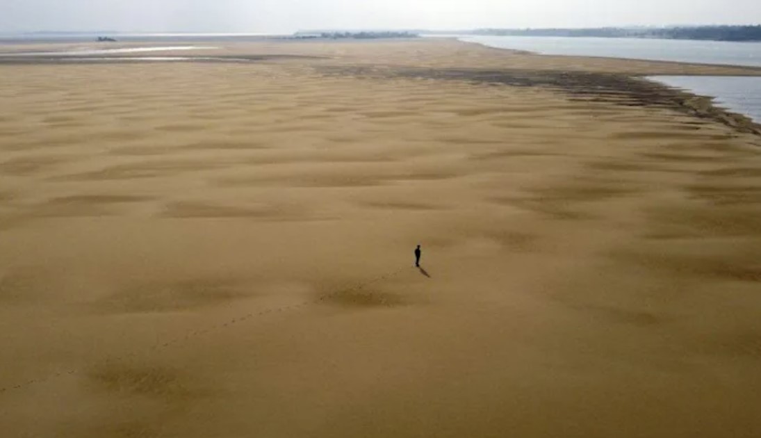
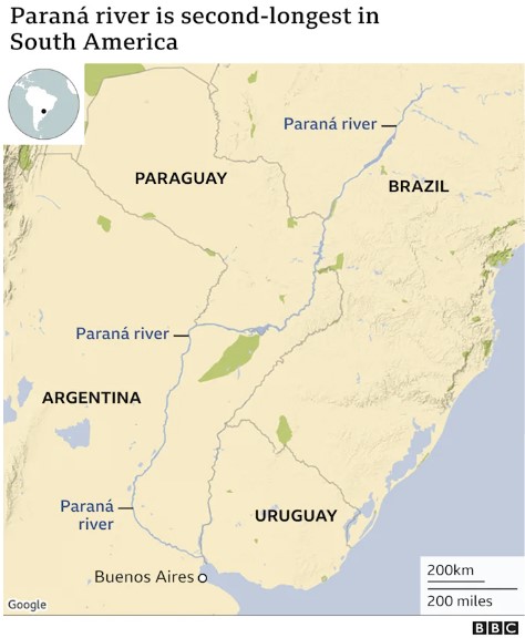
The Parana River, the second-longest river in South America after the Amazon, is about to dry out, leaving millions in fear
The second largest river in South America, the Parana River, is drying out. Picture:BBC
The water levels of the Paraná river, the second-longest in South America after the Amazon, are at their lowest since 1944.
The river is key to commercial shipping and fishing but also provides 40 million people with drinking water.
A drought in the region means water levels have dipped so low that fishers’ livelihoods are at risk.
The Paraná is 4,880km (3,032 miles) long and flows south from south-east Brazil through Paraguay and Argentina.
It merges with the Paraguay and Uruguay rivers to form the Río de la Plata Basin.
“The Paraná is the largest, most biodiverse and the most important socio-productive wetland in Argentina,” explains geologist Carlos Ramonell.
The Parana River is the second longest in South America. Map byBBC
Southern Brazil, where the Paraná’s source is located, has seen three years of below-average rainfalls.
The level of the river is so low that cargo ships have to reduce the amount of grains that are loaded for export.
The Paraguay river is also running very low
As a result, the Paraná’s flow rate has dropped from an average of 17,000 cubic meters a second to just 6,200.
The low water levels arecausing problems for energy production with the hydroelectric plant that spans the Parana river between Argentina and Paraguay running at only 50%.
On Wednesday, Brazil’s Vice-President Hamilton Mourãowarned that the drought could also lead to energy rationing in Brazil.
It is also hampering the transport of goods with ships not able to load up fully in case they run aground.
The Paraná is a key waterway for the transport of grains and the situation is forcing exporters to consider using land routes.
Forecasters say the drought could last until 2022.[BBC]
Comment by Yvonne Lawson on September 2, 2021 at 8:34am
Ida Turns New York Area Into Disaster Area With Catastrophic Flooding
The New York City metropolitan area was struck by sudden disaster on Wednesday night as the remnants ofHurricane Idaflooded subways, roads, and homes across the city and beyond. Intense flooding inundated many areas of the city, Long Island, and across the Hudson in New Jersey.Governor Kathy Hochulhas declared a state of emergency and has asked for federal help for what appears to be the worst natural disaster to strike the city since 2012’sSuperstorm Sandy. Below are updates from the storm.
Subway passengers fled trains, stuck in system
Six trains were stuck in floodwaters and their passengers had to be evacuated, according toNew YorkPost reporter David Meyer, citing the MTA. The Metro-North and Long Island Railroad are “totally offline.”
On CNN, straphangers described being stuck far from home in the Times Square station with no other means home after the city ordered all non-emergency vehicles off the roads until 5 a.m.
Governor Hochul declares a state of emergency
Hochul, in only her eight day in office, appeared on CNN shortly before midnight, saying that Ida’s path through New York was devastating “far more than anyone expected.” Shortly after the appearance, shedeclareda state of emergency, urging New Yorkers to “stay off the roads and avoid all unnecessary travel.” A travel ban in New York City is also in effect until 5 a.m.
All subway service was temporarily suspended
New York City breaks a rainfall record for the second time in less than two weeks
On August 22, Tropical Depression Henri dumped 1.94 inches on Central Park between 10 p.m. and 11 p.m., breaking the record for the most rain in an hour in New York City. Idabestedthat record just 11 days later, dropping three inches of rain between 8:51 and 9:51 p.m. on Wednesday night. The intense downpour caused flooding throughout the city, as well as the first flash-flood emergency ever to be issued in New York City
The Weather Service reports rainfall totals of up to 4.5 to 7 inches in some areas, and more rain is expected. Earlier in the night, the Weather Service issued a tornado warning in some neighborhoods in the Bronx after radar determined a tornado had formed.
New Jersey declares a state of emergency
Just after 10 p.m., Governor Phil Murphy declared a state of emergency
In Newark, parts of Liberty Airport flooded after 3.24 inches of rain was recorded between 8 and 9 p.m. Many areas of New Jersey have reported flooding, including Elizabeth, Jersey City, Passaic, North Plainfield, Short Hills. A bayou boat was deployed in Lambertville
It Just Rained on Greenland's Summit For The First Time in Recorded History
It has just rained at the summit of Greenland's ice sheet for the first time in recorded history, in yet another worrying milestone in our ecological unravelling.
Like much of the Northern Hemisphere, Greenland's been experiencing a massive heatwave with temperatures at the glacier's summit rising above freezing for the third time in less than a decade. On 14 August 2021, at a place normally far too frigid for water to fall as a liquid, the National Snow and Ice Data Center's (NSIDC) Summit Station recorded several hours of rain.
"There is no previous report of rainfall at this location, which reaches 3,216 meters (10,551 feet) in elevation," NSIDC reported, noting the amount of ice lost in one day was seven times more than the daily average for this time of year.
Comment by jorge namour on August 17, 2021 at 8:13pm
Massive wildfire near Jerusalem forces residents to evacuate
08.15.21,++
Firefighters working to contain blaze but say it is advancing quickly amid strong winds, causing a massive black cloud to completely block out sun near the capital
An abnormally massive wildfire near Jerusalem on Sunday forced residents in several small outlying communities to evacuate.
Some homes in the communities of Kiryat Ye’arim and Sho’eva were evacuated as all residents in Ramat Raziel were ordered to leave immediately.
Firefighters were trying to contain the blaze but said it was advancing quickly amid strong winds, causing a massive black cloud that blocked out the sun near the capital.
Teams were also working to fend off the flames from the nearby Eitanim Psychiatric Facility. Ten firefighting planes scrambled to aid in the efforts to extinguish the fire on top of reservist firefighters that were called to the scene. "We are quickly working together with security and rescue services to control the flame," said the head of the Mateh Yehuda Regional Council Niv Vizel. "Council officials are at the scene and are in contact with local communities. We urge all residents and visitors to comply with police so we can get the situation under control as soon as possible."
The Jerusalem area has been a hotspot for wildfires over the past months due to tinder-like summer conditions. Two weeks ago, a wildfire nearly reached a local mall and gas station, forcing Highway 1 to be closed off for nearly two hours.
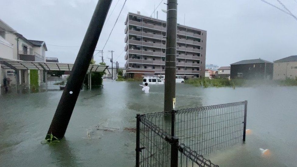
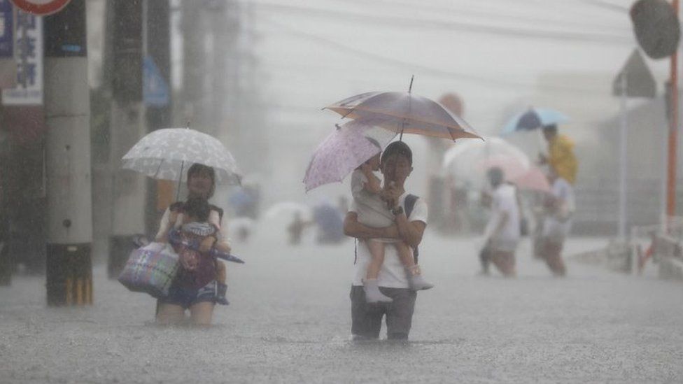
Japan rain: Nearly two million residents told to seek shelter
Nearly two million people have been urged to evacuate their homes amid heavy rainfall in parts of Japan.
Highest-level rain warnings have been issued in a number of prefectures, including Fukuoka and Hiroshima.
One woman has died and her husband and daughter are missing after a landslide destroyed two homes in Nagasaki prefecture.
More than 150 troops, police and firefighters have been sent to help with rescue operations in the area.
"They are carefully searching for the missing residents, while watching out for further mudslides as the heavy rain continues," a local official told the AFP news agency.
The west of the country is worst affected but heavy downpours are expected across the country in coming days.
In Saga prefecture, a hospital evacuated patients to its upper floors on Saturday after the nearby Rokkaku river overflowed and flooded the building, Kyodo News agency reported, citing local authorities.
In total, non-compulsory evacuation warnings are now in place for more than 1.8 million people across seven prefectures, according to Japanese broadcaster NHK.
Yushi Adachi, from Japan's meteorological agency, described the current rainfall as "unprecedented".
"It's highly likely that some kind of disaster has already occurred," he said.
Streets in Fukuoka prefecture were photographed flooding on Saturday
Experts warn the rain is forecast to continue throughout the week
Local television footage showed submerged roads. Rivers in Saga and Fukuoka have overflowed with water levels still rising, local media reports said.
An official in Kumamoto, south-western Japan, said a 76-year-old man was missing after trying to secure his fishing boat.
Athens: Major fire prompts evacuation of residential areas
A major blaze threatened northern suburbs of the Greek capital
A fire broke out on Tuesday afternoon in Varybobi, a northern suburb of Athens.
The Greek national road, which runs from Athens to Lamia has been closed due to the blaze.
The fire is thought to have started in the nearby heavily forested area of Kryoneri, but has spread significantly throughout the afternoon.
Evacuation of Varibobi was ordered short after 4:30 p.m.
As the blaze is near some power substation there are reports of problems in the power surgeand thus on the hottest day in the Greek capital where over42 degrees Celsius are being recorded.
Comment by Tracie Crespo on August 5, 2021 at 3:32am
Lightning strikes in Bangladesh kill 16 at wedding party
Several lightning bolts hit the wedding party within a few seconds, killing at least 16 people and injuring the groom.
4 Aug 2021
Several lightning bolts have hit a wedding party in Bangladesh within a few seconds, killing at least 16 people and injuring the groom, officials say.
The group had just left a boat at the riverside town of Shibganj to take shelter from the thunderstorm when the lightning struck, a government administrator for the town said on Wednesday.
The bride was not with the wedding party, Sakib Al-Rabby told the AFP news agency, confirming that 16 people died as several bolts struck within a few seconds of each other in the western district of Chapainawabganj.
A week of torrential rains in the southeastern district of Cox’s Bazar left some 20 dead, including six Rohingya refugees.
Lightning kills hundreds of people in the South Asian nation each year.
According to an official tally, there were more than 200 lightning deaths in 2016, with 82 people dying on a single day in May.
Many deaths are never officially recorded, however, and one independent monitor counted at least 349 deaths from lightning strikes.
Some experts say deforestation has increased the death toll. Bangladesh has planted hundreds of thousands of palm trees in a bid to ease the impact of climate change and reduce the number of lightning deaths.


You need to be a member of Earth Changes and the Pole Shift to add comments!
Join Earth Changes and the Pole Shift