
Newsweek
Japan issues tsunami warning after 6.7 magnitude earthquake
Story by
• 4h •
Honolulu Roads And Gas Stations Crowded Amid Tsunami Warning
Earthquakes Today, November 7, 2025
Altering Earthquakes:
As of late, I have observed that USGS and EMSC are a bit lax on their reports of earthquakes. Sometimes not seeing anything reported for hours from the last update, or seeing periods of 90-200 minutes with no earthquakes in between. My question is, are they leaving swarms of earthquakes out of their reports, or there are actually periods of no earthquakes?
SOZT: Greater than 90% of the earthquake activity is being altered by the USGS at present, which is under orders to prevent any clue being given to the public about the Earth changes caused by the presence of Planet X. Over a decade ago, the approach was to de-sensitize the live seismographs periodically, so the displays do not turn black worldwide, and to ignore the twice-a-day patterns showing up on these seismographs. Then any quakes that could be dropped were dropped. This was obvious to some who were watching the database manipulation. Quakes in the list would suddenly disappear. This was particularly the case where a quake happened in a remote location, or out in the ocean. Dumbing down the magnitude quickly followed, but in order to ensure the public did not notice, the USGS took control of all websites reporting quake statistics. At times, this control breaks, and discrepancies are reported to the public. Some countries rebel. Quake swarms are another source of control, as they pepper the databases with many quakes and skew the statistics, and thus are pulled from the database. Else the question is raised, why so many? EOZT
Will the USGS internet system be a reliable warning system for the European tsunami by registering on the net the New Madrid earthquake on the exact time it occurs?
SOZT: It will not be a lack of information from the USGS that will be the point of confusion during the earthquakes leading up to the New Madrid adjustment, it will be knowing which quake is the big one vs the many minor quakes preceding it. The USGS downgrades almost all earthquakes, to prevent meaningful statistics from being generated from their databases. They also exclude quakes whenever they can, but this is unlikely to happen in the New Madrid area as it is in the center of a populated land mass. Thus you will have magnitude 6 quakes that will be called a 5.2, magnitude 7 quakes called a 6.1, and when a magnitude 8 or greater quake occurs, it will be called a 6.9.
We would advise that rather than watching the USGS quake statistics, that you watch the Earth changes. The adjustment that will incite the European tsunami will involve bridges on the Mississippi breaking, and being impassable. The land to the west of the Mississippi will drop so that the Mississippi will become 50 miles wide in the state of Mississippi. Watch for this. The New Madrid adjustment will be several large quakes of magnitude 8-9, though will be listed as a lesser magnitude. As the N American continent continues to unzip up to and along the Seaway, the quakes will be less than a magnitude 8 but very destructive to Cleveland and Toledo and Buffalo and the inland locks along the Seaway. Thus it is not what the USGS says that should be watched, but the condition of the bridges on the Mississippi, the impact on the cities along the Seaway, and whether the inland locks are reported as inoperable. EOZT
Views: 580805
Comment
Was a 5.9 just a few minutes ago...
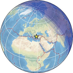
| Magnitude | 5.3 |
| Region | CYPRUS REGION |
| Date time | 2025-11-12 14:23:33.0 UTC |
| Location | 34.815 ; 32.518 |
| Depth | 14 km |
| Distance | 50 km W of Limassol, Cyprus / pop: 154,000 / local time: 16:23:33.0 2025-11-12 10 km NE of Paphos, Cyprus / pop: 35,900 / local time: 16:23:33.0 2025-11-12 |

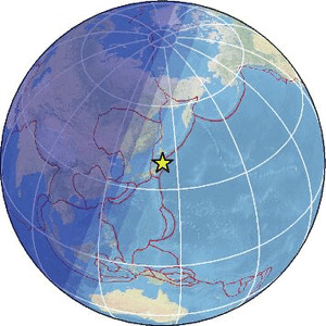
| Magnitude | 6.0 |
| Region | OFF EAST COAST OF HONSHU, JAPAN |
| Date time | 2025-11-10 07:23:18.2 UTC |
| Location | 39.580 ; 143.367 |
| Depth | 10 km |
| Distance | 189 km ESE of Hachinohe, Japan / pop: 239,000 / local time: 16:23:18.2 2025-11-10 122 km E of Miyako, Japan / pop: 51,700 / local time: 16:23:18.2 2025-11-10 |
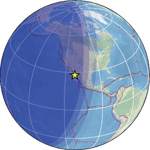
| Magnitude | 5.6 |
| Region | ANTOFAGASTA, CHILE |
| Date time | 2025-11-10 10:49:30.7 UTC |
| Location | -23.437 ; -70.376 |
| Depth | 47 km |
| Distance | 526 km W of Salta, Argentina / pop: 512,000 / local time: 07:49:30.7 2025-11-10 24 km N of Antofagasta, Chile / pop: 309,000 / local time: 07:49:30.7 2025-11-10 |
Japan issues tsunami warning after 6.7 magnitude earthquake
Japanese authorities issued a tsunami alert for the northeast of the country on Sunday after a magnitude 6.7 earthquake was recorded in the Pacific Ocean, close to the country.
Japan sits on the Pacific’s earthquake belt, often dubbed the ocean’s “ring of fire.” Around 90 percent of all the world’s earthquakes happen along the 25,000-mile horseshoe.
Earthquakes or undersea volcanic eruptions can trigger tsunamis. These waves can be small and only impact a localized area, or cause widespread destruction.
Japan’s “complex coastline is vulnerable to tsunamis,” Tokyo’s Foreign Ministry has said. The vast majority of tsunamis occur in the Pacific Ocean, although they can happen in any large body of water.
Tsunamis of up to 1 meter, around 3.2 feet, could reach land in Japan’s Iwate Prefecture, the Japan Meteorological Agency said. Areas to the north and south of the region may see a slight rise in sea levels.
The earthquake struck shortly after 5 p.m. local time on Sunday (3 a.m. ET) at a depth of roughly 10 kilometers, or about 6 miles, the weather agency said.
An earthquake measured at 4 on the Shindo scale will likely cause lights to swing violently and some objects to overturn, while drivers in vehicles will likely feel the impact.
Some bullet train services were temporarily stopped and a power outage was detected in an unspecified area, Japan’s Kyodo News Agency reported. A tsunami wave reaching 10 centimeters was recorded in the coastal city of Ofunato and a “minor” wave reached Miyako, a city just north of Ofunato, according to the news agency.
Close to 20,000 people were killed in March 2011 in Japan after a powerful earthquake triggered a huge tsunami in the country’s northeast, sometimes referred to as the Great East Japan earthquake.
The 40-meter-high tsunami took out the power supply and cooling of three nuclear reactors at Japan’s Fukushima nuclear power plant in one of the world’s worst-ever nuclear disasters. Thousands of people were evacuated from the area.
Scientists said at the time the earthquake was powerful enough to shift the Earth’s axis. It was the largest magnitude earthquake ever recorded in Japan.
Japanese authorities said around 122,000 buildings were entirely destroyed and another 283,000 significantly damaged. Just short of 750,000 buildings sustained some level of damage.
The earthquake and tsunami racked up roughly $235 billion in damages, the World Bank estimated shortly after the disaster.
Update 11/9/2025 at 5:25 a.m. ET: This article has been updated with additional information.
M 6.8 - 126 km E of Yamada, Japan
2025-11-09 08:03:37 (UTC)39.396°N 143.411°E10.0 km depth
https://earthquake.usgs.gov/earthquakes/eventpage/us6000rmea/executive
6.4
121 km E of Yamada, Japan
2025-11-09 05:54:36 (UTC-03:00)
10.0 km
2.7
8 km WSW of Coquille, Oregon
2025-11-09 07:04:05 (UTC-03:00)
13.8 km
5.2
126 km E of Yamada, Japan
2025-11-09 06:52:43 (UTC-03:00)
10.0 km
4.8
190 km E of Atka, Alaska
2025-11-09 06:36:50 (UTC-03:00)
43.4 km
5.7
134 km E of Miyako, Japan
2025-11-09 06:28:23 (UTC-03:00)
10.0 km
4.6
127 km E of Yamada, Japan
2025-11-09 06:21:35 (UTC-03:00)
10.0 km
5.0
104 km E of Yamada, Japan
2025-11-09 06:16:58 (UTC-03:00)
10.0 km
5.4
123 km E of Yamada, Japan
2025-11-09 06:10:47 (UTC-03:00)
10.0 km
5.2
125 km E of Yamada, Japan
2025-11-09 05:49:50 (UTC-03:00)
10.0 km
5.6
125 km E of Yamada, Japan
2025-11-09 05:34:01 (UTC-03:00)
10.0 km
2.6
47 km S of Glacier View, Alaska
2025-11-09 05:17:48 (UTC-03:00)
12.4 km
5.9
127 km E of Yamada, Japan
2025-11-09 05:14:53 (UTC-03:00)
10.0 k
5.5
107 km E of Yamada, Japan
2025-11-09 05:11:25 (UTC-03:00)
10.0 km
4.5
26 km ESE of Santa María Chimalapa, Mexico
2025-11-09 04:06:12 (UTC-03:00)
114.1 km
5.5
147 km NE of Port Blair, India
2025-11-09 03:38:31 (UTC-03:00)
133.2 km
4.5
29 km S of Shizunai-furukawachō, Japan
2025-11-09 01:16:41 (UTC-03:00)
67.7 km
4.9
35 km SSW of Puerto El Triunfo, El Salvador
2025-11-08 22:49:05 (UTC-03:00)
65.9 km
4.6
164 km SSE of Vilyuchinsk, Russia
2025-11-08 21:17:33 (UTC-03:00)
51.2 km
5.1
131 km E of Yamada, Japan
2025-11-08 21:17:29 (UTC-03:00)
10.0 km
5.0
114 km E of Yamada, Japan
2025-11-08 19:33:50 (UTC-03:00)
41.7 km
5.1
132 km E of Yamada, Japan
2025-11-08 19:26:58 (UTC-03:00)
10.0 km
5.6
125 km E of Yamada, Japan
2025-11-08 19:15:08 (UTC-03:00)
19.2 km
4.8
South Sandwich Islands region
2025-11-08 14:51:30 (UTC-03:00)
107.2 k
3.1
22 km SSW of Mammoth, Wyoming
2025-11-08 12:04:19 (UTC-03:00)
9.3 km
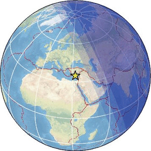
| Magnitude | 5.8 |
| Region | OFF EAST COAST OF HONSHU, JAPAN |
| Date time | 2025-11-08 21:04:17.4 UTC |
| Location | 39.330 ; 143.614 |
| Depth | 20 km |
| Distance | 215 km E of Morioka, Japan / pop: 295,000 / local time: 06:04:17.4 2025-11-09 148 km E of Miyako, Japan / pop: 51,700 / local time: 06:04:17.4 2025-11-09 |
Already downgraded...
| Magnitude | 5.7 |
| Region | GULF OF CALIFORNIA |
| Date time | 2025-11-07 12:04:31.1 UTC |
| Location | 27.971 ; -111.965 |
| Depth | 10 km |
| Distance | 105 km W of Heroica Guaymas, Mexico / pop: 113,000 / local time: 05:04:31.1 2025-11-07 76 km NNE of Santa Rosalía, Mexico / pop: 11,700 / local time: 05:04:31.1 2025-11-07 |
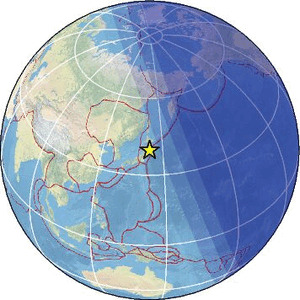
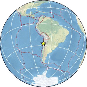
| Magnitude | 5.7 |
| Region | OFFSHORE ATACAMA, CHILE |
| Date time | 2025-11-03 15:51:54.0 UTC |
| Location | -27.404 ; -71.484 |
| Depth | 12 km |
| Distance | 279 km NNW of La Serena, Chile / pop: 154,000 / local time: 12:51:54.0 2025-11-03 114 km WSW of Copiapó, Chile / pop: 129,000 / local time: 12:51:54.0 2025-11-03 |
| Magnitude | 5.0 |
| Region | WESTERN TURKEY |
| Date time | 2025-11-03 12:35:38.8 UTC |
| Location | 39.169 ; 28.341 |
| Depth | 11 km |
| Distance | 66 km SE of Balıkesir, Turkey / pop: 238,000 / local time: 15:35:38.8 2025-11-03 16 km ESE of Sındırgı, Turkey / pop: 10,900 / local time: 15:35:38.8 2025-11-03 |
Nancy Lieder, Emissary of the Zetas.
https://poleshift.ning.com/xn/detail/3863141:Comment:1168188
Awakening to the Alien Presence ZetaTalk
The truth will likely never to be known to the public but be washed away in the Nibiru panic soon to engulf the world.
The Worst of the Cover-Up
https://poleshift.ning.com/profiles/blogs/the-worst-of-the-cover-up
Main Establishment Lies
https://poleshift.ning.com/profiles/blogs/main-establishment-lies
© 2025 Created by 0nin2migqvl32.
Powered by
![]()
You need to be a member of Earth Changes and the Pole Shift to add comments!
Join Earth Changes and the Pole Shift