Sinkhole Incidents On the Rise
"Stretch zones primarily experience sinking ground, as the support in the rock strata is stretched thin. Thus, buildings implode and gas and water mains break." ZetaTalk
--------------------------------------------------------------------------------------------------------------------------------------
What happens to rock layers under a diagonal pull, or being pulled apart? As can be seen during recent years, this has resulted in derailing trains, sinkholes suddenly appearing, gas and water main breaks, torn roadways and separating bridges. Despite the effect on man, crawling about on the surface of what they assume to be terra firma, these changes are superficial. When the pulling starts, weak points break and thereafter the plumbing and roadways hold, giving the impression that the pulling has stopped, but this is misleading. The North American continent is giving evidence that its rock layers are separating from each other, and sliding sideways in a diagonal, thus exposing portions of these layers to vent into the air above. If rock is being stressed, then where are the earthquake predictors giving evidence of this, the frantic animals, the static on the radio, the earthquake swarms? Rock in the stretch zone, pulling apart rather than compressing, does not emit the particles flows that animals and radios sense, nor register on instruments are tension and release quakes.
--------------------------------------------------------------------------------------------------------------------------------------
Click on image to zoom in.
Click on image to zoom in.
--------------------------------------------------------------------------------------------------------------------------------------
"We have repeatedly stated that the Earth changes will not diminish, but will increase going into the pole shift.
This is not a lineal matter, as the closer Planet X comes to Earth, an inevitable path, the more the torque effect and the polar wobble where the N Pole of Earth is pushed away violently on a daily basis, occur. The wobble will become more pronounced, more violent. The plates are tugged back West of the Atlantic, pulled forward East of the Atlantic, during the daily rotation of the Earth. The North American continent is allowed to roll East during rotation while the S Pole is pulled West, creating the diagonal pull likely to trigger the New Madrid fault line into an adjustment, and soon. The N Pole is pushed away and allowed to bounce back, daily, as the Earth rotates, a wobble that puts stress on all fault lines when the plates are suddenly in motion, and suddenly stopped!
"As there is no other explanation for the effect on the stretch zone, lacking any earthquakes to blame, and as these stretch zone accidents will continue to emerge, and with ferocity, this is a certain clue to those on the fence, that the influence of Planet X is the cause. Or is it Global Warming?"
ZetaTalk Chat Q&A for April 13, 2013
"Sinkholes almost invariably form in areas subject to karst limestone cavern formation. Underground water flows eat away the limestone leaving vast caverns and caves, which often give scant indication above ground that a cavern lies below. Karst limestone rock formations have been mapped and are known, however, but since one never knows just where a cavern might have formed, this provides little help in predicting just where a sinkhole might form. Sinkholes open up when the rock is fractured due to stress from being in the stretch zone, from the bending of a plate, or due to torsion."
--------------------------------------------------------------------------------------------------------------------------------------
Check your safe locations:
Views: 244298
Comment
-
Comment by Recall 15 on January 28, 2020 at 10:23pm
-
Sinkholes @ Cayman Island, after the Mag 7.7 Quake January 28, 2020 -Captured images-
From Link:
-
-
Suchitepéquez, Guatemala January 20, 2020
A sinkhole in route RDSCH-01, Suchitepéquez
via Twitter:
https://twitter.com/ConredGuatemala/status/1219330892092657669/phot...
-
Comment by Starr DiGiacomo on January 16, 2020 at 7:51am
-
https://pakobserver.net/huge-sinkhole-swallows-bus-kills-nine-in-ch...
Huge sinkhole swallows bus, kills nine in China
-
Comment by Khan on December 30, 2019 at 9:34am
-
Spain:The sinking of land in Arcas grows and the transit of heavy vehicles is prohibited.
Dec 29, 2019
From the City Councils of Arcas and Villar de Olalla, they ask for caution and avoid traveling along the road between the two locations due to the danger of landslides
The pool that arose in Arcas after the sinking of land recorded this Friday continues to grow and already reaches a diameter close to eight meters. Its proximity to the road that connects this municipality with Villar de Olalla has led the two municipalities to issue a side asking for caution to the neighbors who transit through this area, located about two kilometers from the town center of Arcas.Given the danger of landslides, citizens are asked to avoid circulating in this area as much as possible. In addition, the passage of vehicles weighing more than 3,500 kilos has been strictly prohibited.
It should be remembered that the subsidence of lands, possibly related to the increase in the water table of the underground currents that circulate in this area, near the Ballesteros lagoon complex, caused this Friday the collapse of land giving rise to a seven-meter dolina depth that flooded with water.
-
-
Large Hole Suddenly Appears in Maros.Dec 23, 2019
 SULSELONLINE.COM, MAROS - Residents of the village of Lebbo Tengae, District of Cenrana, Maros Regency, were horrified by a large hole that suddenly appeared on Monday (12/23/2019).
One resident, Mappiare (40 years), claimed to have initially seen smoke rising from the rice fields. After a few minutes, a roar could be heard that shocked the residents.
"At first I saw that there was smoke like burning. Then there were sounds like thunder and bulldozers. Then I approached and looked at it. But the width is still like an ordinary well, "he told reporters.
The depth of the hole was initially 50 meters with an initial diameter of about 2 meters. But this hole continues to expand to a diameter of about 15 meters.
"The land continues to fall into the water, so it widens. The ground is still falling inward, it could be wider. Because now there are already 15 meters wide, "he added.
Residents continue to arrive because they are curious about the appearance of giant holes. The police are now putting a dividing line.
Camba Maros police chief, AKP Haedar Muis, said that since the emergence of the big hole, this morning, residents continued to arrive.
"Many residents from other villages have come out of curiosity to see. Earlier, the police had already been given a line because it was feared that residents would approach and fall. That land does not stop sinking, "he said.
-
-
Indonesia: The ground collapsed in Maros.
Dec 23, 2019
-
-
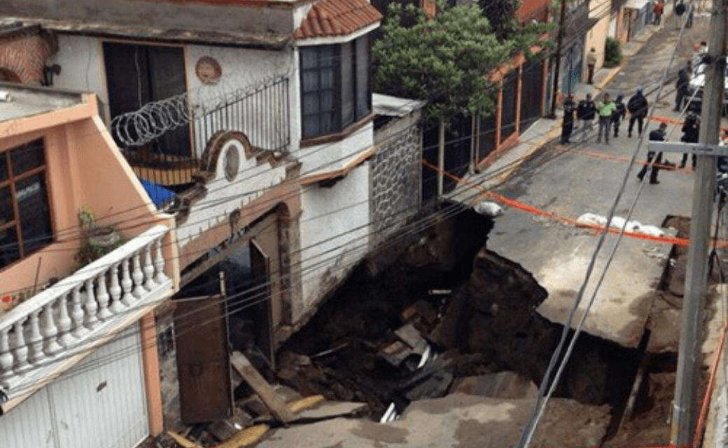
Mexico: Several sinkholes have been presented in various municipalities of Mexico City.
Dec 16, 2019
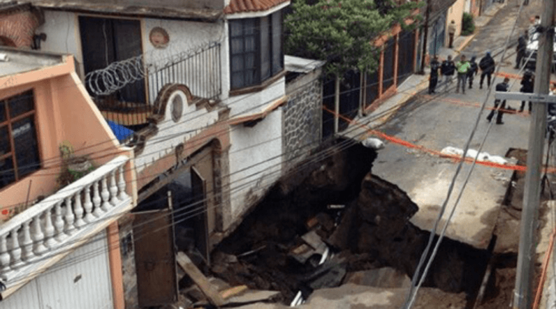 In the last week, several sinkholes have been presented in various mayor's offices in Mexico City.
On December 14, in Tláhuac, a 7-meter deep hole was opened in which two people remained inside a vehicle. The Rescue and Medical Emergency Squadron (ERUM) gave them attention.
The same day, but another incident occurred in Benito Juárez. It is presumed that it originated from a water leak.
On December 13, a hole was formed in Iztapalapa with a depth of 14 meters, in the town of Santa María Acahualtepec. About 70 people living around the incident were evicted.
-
Comment by Juan F Martinez on December 13, 2019 at 4:08pm
-
Drivers and passengers have lucky escape after hole swallows cars in southeast China Published: 13 Dec, 2019
Sinkhole suddenly opened up near subway station in city of Xiamen but no one is killed or injured
Taxi driver whose vehicle was swallowed up says he and his passenger were able to pull themselves free unaidedhttps://www.scmp.com/news/china/society/article/3042000/drivers-and...
-
-
South Korea : Massive sinkhole in Busan.
Dec 11, 2019
Massive sinkhole in Busan has caused traffic congestion on the main road.
The sinkhole is estimated to be about 6 meters wide and 5 meters long.

-
-
Sinkhole, Guangzhou, CHINA 12-1-2019
https://www.facebook.com/rodolfomartin.brenessalvatierra.5/videos/1...
SEARCH PS Ning or Zetatalk
Nancy Lieder, Emissary of the Zetas.
https://poleshift.ning.com/xn/detail/3863141:Comment:1168188
Awakening to the Alien Presence ZetaTalk
The truth will likely never to be known to the public but be washed away in the Nibiru panic soon to engulf the world.
The Worst of the Cover-Up
https://poleshift.ning.com/profiles/blogs/the-worst-of-the-cover-up
Main Establishment Lies
https://poleshift.ning.com/profiles/blogs/main-establishment-lies
Donate
© 2025 Created by 0nin2migqvl32.
Powered by
![]()
You need to be a member of Earth Changes and the Pole Shift to add comments!
Join Earth Changes and the Pole Shift