Sinkhole Incidents On the Rise
"Stretch zones primarily experience sinking ground, as the support in the rock strata is stretched thin. Thus, buildings implode and gas and water mains break." ZetaTalk
--------------------------------------------------------------------------------------------------------------------------------------
What happens to rock layers under a diagonal pull, or being pulled apart? As can be seen during recent years, this has resulted in derailing trains, sinkholes suddenly appearing, gas and water main breaks, torn roadways and separating bridges. Despite the effect on man, crawling about on the surface of what they assume to be terra firma, these changes are superficial. When the pulling starts, weak points break and thereafter the plumbing and roadways hold, giving the impression that the pulling has stopped, but this is misleading. The North American continent is giving evidence that its rock layers are separating from each other, and sliding sideways in a diagonal, thus exposing portions of these layers to vent into the air above. If rock is being stressed, then where are the earthquake predictors giving evidence of this, the frantic animals, the static on the radio, the earthquake swarms? Rock in the stretch zone, pulling apart rather than compressing, does not emit the particles flows that animals and radios sense, nor register on instruments are tension and release quakes.
--------------------------------------------------------------------------------------------------------------------------------------
Click on image to zoom in.
Click on image to zoom in.
--------------------------------------------------------------------------------------------------------------------------------------
"We have repeatedly stated that the Earth changes will not diminish, but will increase going into the pole shift.
This is not a lineal matter, as the closer Planet X comes to Earth, an inevitable path, the more the torque effect and the polar wobble where the N Pole of Earth is pushed away violently on a daily basis, occur. The wobble will become more pronounced, more violent. The plates are tugged back West of the Atlantic, pulled forward East of the Atlantic, during the daily rotation of the Earth. The North American continent is allowed to roll East during rotation while the S Pole is pulled West, creating the diagonal pull likely to trigger the New Madrid fault line into an adjustment, and soon. The N Pole is pushed away and allowed to bounce back, daily, as the Earth rotates, a wobble that puts stress on all fault lines when the plates are suddenly in motion, and suddenly stopped!
"As there is no other explanation for the effect on the stretch zone, lacking any earthquakes to blame, and as these stretch zone accidents will continue to emerge, and with ferocity, this is a certain clue to those on the fence, that the influence of Planet X is the cause. Or is it Global Warming?"
ZetaTalk Chat Q&A for April 13, 2013
"Sinkholes almost invariably form in areas subject to karst limestone cavern formation. Underground water flows eat away the limestone leaving vast caverns and caves, which often give scant indication above ground that a cavern lies below. Karst limestone rock formations have been mapped and are known, however, but since one never knows just where a cavern might have formed, this provides little help in predicting just where a sinkhole might form. Sinkholes open up when the rock is fractured due to stress from being in the stretch zone, from the bending of a plate, or due to torsion."
--------------------------------------------------------------------------------------------------------------------------------------
Check your safe locations:
Views: 243044
Comment
-
Comment by Howard on September 20, 2012 at 5:06am
-
A pair of significant water main breaks leaving sinkholes today in both Winnipeg and Montreal, Canada. (Sep 19) -
http://montreal.ctvnews.ca/broken-water-main-floods-homes-in-longue...
"A broken water main flooded more than a dozen homes on Roland-Therrien Blvd. in Longueuil on Wednesday morning.
According to the Longueuil police, the main broke at around 4:38 a.m., sending a spectacular plume of water up from the centre of the otherwise busy street. The torrent along the street was more than 30 cm deep at 7:00 a.m.
“We don’t know what caused this,” said Longueuil spokesman Jacques Tetrault about the broken 30-year-old pipe. “It’s a young street, only 30-years-old, and there was no construction work around. So we have no clue about what happened.”
The water main which cracked on the street was a pipe used to feed water to smaller communities on the south shore surrounding Longueuil—an explanation for the powerful flow of water. While crews from public works, the Longueuil fire department and Hydro Quebec are at the scene, the water was flowing hours after the break.
According to the City of Longueuil, water crews had to slowly divert water away from the main out of fears of breaking other pipes due to a sudden change of pressure. The flow of water was finally stopped almost six hours after the break.
While no evacuation orders were issued, the garages and basements of 15 homes were flooded. The broken pipe left a crater nearly 20 feet across in the road.
Police are asking drivers to avoid the area between Robervale St. and Toulouse St."
and in Winnipeg,
http://www.cbc.ca/news/canada/manitoba/story/2012/09/19/mb-watermai...
"A watermain break left about a dozen homes without water in Winnipeg's North End on Wednesday.
The break, on the 1000 block of Magnus Avenue, happened at about 4 a.m. and filled the street with a shin-deep muddy water.
It also caused a sinkhole to form. City crews were forced to turn off water supply to the homes in the immediate area for several hours."
-
Comment by Beva on September 18, 2012 at 4:48pm
-
Sinkhole swallows tractor in Florida road
Titusville road closed because of sinkhole

http://www.local10.com/news/Sinkhole-swallows-tractor-in-Florida-ro...
-
-
Three more sinkholes open in Gatineau, Canada
Heavy rain is being blamed for a trio of sinkholes in Gatineau Saturday.
Motorists got out of their cars, peering into a large sinkhole surrounded by metal barricades and orange detour signs at Jacques-Cartier and Saint Antoine streets, taking photos.
Cops received a call at 10:37 a.m., said Gatineau police Lieut. Yves Comtois.
The cause is being determined.
Later in the day, a second sinkhole opened up 2 km north at Saint Antoine St. and Chemin de la Savane, behind the Promenade de l’Outaouais shopping centre.
A broken water main is likely to blame, said Comtois.
Detours were in place.
“They’re not the main roads, but lots of cars go through,” said Comtois.
“It’s pretty commercial.”
From there, a third hole surfaced in a residential area about 5 km east at Magnus Rd. W. & Francois St.
This hole was considerably smaller, said Lieut. Mike Lachapelle.
Meanwhile, work continued on the sinkhole in Ottawa on Hwy. 174 with five pieces of pipe being delivered on Sunday.
Cumberland Coun. Stephen Blais said he’s closely monitoring the work being done — and the accompanying traffic issues.
“I got some very positive feedback on Thursday, and Friday appeared to be the best commute to date,” he said Saturday.
With buses being diverted to the west-bound lane going east, the shoulder of that roadway was paved, but the torrential rain on Saturday played havoc with that work.
“We do some shoulder paving to help facilitate (the buses), but the rain over (Friday) night destabilized it,” he said. “So we’re down a lane (Saturday) and they’re back working on that. Right now, we need to let the contractors do their work so that we’re good to go on Monday.”
-
-
Sinkhole Swallows North Carolina Driver (September 6) -
http://www.nydailynews.com/news/national/sinkhole-swallows-north-ca...
Law student Rajiv Thairani, 27, was turning around in an empty lot next to a Bojangles chicken outlet in Durham, N.C., near his Duke University campus, when the vehicle he was driving suddenly dropped eight feet into the ground.
Rajiv Thairani, 27, was turning around in an empty lot next to a Bojangles Famous Chicken 'n Biscuits in Durham, N.C., near his Duke University campus, on Tuesday when he struck the sinkhole.
“My initial reaction was that the ground underneath me had given way, like it had collapsed,” Thairani, originally from San Francisco, told ABC News.
The gaping hole wasn’t visible from the street and hadn’t been marked off, but Thairani says he wasn’t the first to encounter it.
“This apparently happened to someone the night before, a truck driver,” he told ABC News. “His tires got stuck but his truck [an 18-wheeler] was too big to go in.
“They called 911 and put up caution tape but by the next day the caution tape had blown away and poles had fallen over so it was no longer visible.”
-
Comment by KM on September 5, 2012 at 6:34pm
-
Sinkhole could close Ottawa highway for days
Highway 174 eastbound could be closed for days as sinkhole grows to size of 'Olympic pool'
CBC News
Posted: Sep 5, 2012 7:04 AM ET
Last Updated: Sep 5, 2012 12:27 PM ET
RAW Sinkhole survivor2:46
 Ottawa man escaped a highway sinkhole, which has grown to the size of an "Olympic-sized pool", after his car was swallowed during afternoon rush hour yesterday.
Juan Pedro Unger told CBC News he was driving home eastbound on Highway 174 in the east Ottawa community of Orleans when he saw a black patch ahead in his lane near the Jeanne d'Arc Boulevard exit.
This sinkhole swallowed Juan Pedro Unger's four-door sedan as he drove home during rush hour Tuesday in east Ottawa. (Photo courtesy of Ottawa Fire Services)
At first, Unger said, he thought it was a tarp. But when he discovered it was a large hole, it was too late to stop.
"I couldn't make a radical manoeuvre, it could have caused an accident," he said. "I just tried to come to a stop, but I couldn't and it just sunk in."
Unger's silver four-door sedan went nose first into the sinkhole just after 5 p.m. ET Tuesday.
He said there was a large banging sound as the car rattled around in the hole. Only its bumper did not go below the surface.
Fear of car sinking further
Unger hung from his seatbelt and he said he thought of two options — either try to get out, or stay in the car and wait for help.
At first, he feared a bus or car would come along and land on his car. But then he also recognized there was eroding water and pavement beneath him, and he feared the vehicle could sink further.
Juan Pedro Unger feared his vehicle would sink further underground as he sat in his driver's seat in the sinkhole. (CBC)
"There were two big gaps with water flowing into them like a river was forming, and completely pitch black under it," Unger said.
"Those two holes, you couldn't tell how deep they were. They could be a metre, they could be 100 metres."
Unger managed to get his door open and he crawled out, using the door to prop himself up. He began to climb through the hole when two witnesses reached in to help him out.
"It was a huge relief to be out and alive," he said.
Car remains in sewer pipe
The sinkhole will take days, not hours to repair, staff told the city's transportation committee Wednesday. Contractors had begun to assess the sewer pipe Tuesday as part of a $1.5-million repair job.
Staff said workers need to replace the approximately 50-year-old, 3.6-metre-wide sewer pipe that cuts across under the highway. Unger's vehicle also remains 20 metres down in an underground sewer pipe flowing towards the Ottawa River.
Juan Pedro Unger escaped with only minor scrapes and bruises after falling into the sinkhole. (CBC)
The city's environmental services department says there will not be environmental damage caused by the sinkhole or the vehicle. Staff are currently using dikes at the sewer outflow to prevent car contaminants from entering the sewage system.
The eastbound lanes of Highway 174 remain closed between the Blair Road and Jeanne d'Arc exits.
Officials say the closure could last days, or maybe even weeks, for the repair to be completed. Tuesday night's rainfall also made the assessment of the sinkhole more difficult for the excavation company.
http://www.cbc.ca/news/canada/ottawa/story/2012/09/05/ottawa-sinkho...
-
Comment by lonne rey on August 22, 2012 at 11:11pm
-
What causes Hanoi’s sinkhole is still in controversy
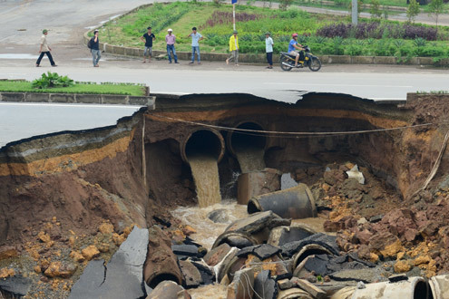
On August 20, the hole kept spreading to more than 20m wide, 30m long and 7m deep, causing serious traffic jams on Hanoi’s key role. The hole is very close to the USilk City apartment building, invested by the Song Da Thang Long JS Company.
The hole can continue expanding.
-
-
Massive Sinkhole Threatens School in Erwin, Tennessee (August 18) -
http://www.johnsoncitypress.com/News/article.php?id=101910
A sinkhole was found early Saturday morning approximately 30 feet from Love Chapel Elementary School.
The hole was around 25 feet across, 60-70 feet deep and continuing to fall in. After about an hour, the hole had grown in depth to approximately 122 feet, with around 10-15 feet of water inside.
Hensley said Terry Haynes, highway chief administrator officer, was called in and began making plans to fill the hole with boulders and other materials, while also putting a dye in the water to track the water flow.
He said access to the area near the sinkhole and the school has been blocked off to the public as emergency personnel and workers survey the scene.
Hensley said a previous sinkhole found a few months back in a swimming pool area on private property was tracked to be 300 feet from the current sinkhole and those involved are investigating the area to determine whether it is a fault.
He said Denise Brown, director of schools for Unicoi County, has canceled school Monday at Love Chapel, is assessing the sinkhole area with officials and will be releasing a statement about how they plan to proceed at a later time.
-
-
Infamous Louisiana Sinkhole Swallows More Land, Cleanup Efforts Suspended (August 16) -
http://www.wafb.com/story/19295398/sink-hole-swallows-more-land-wor...
Authorities said a giant sink hole in Louisiana has "eaten" another chunk of land and a boat, but fortunately, two workers were rescued before the boat sunk.
The Assumption Parish Police Jury reported a 50-foot section of property fell into the sink hole in the Bayou Corne/Grand Bayou area during cleanup operations Thursday morning.
The lost land was on the southwest side of the site.
Two workers in a boat were rescued by airboat shortly before their vessel became the latest casualty of the slurry. The boat had been tied to a tree, but it was taken by the sink hole anyway.
Officials said no injuries were reported.
Cleanup operations at the site have been suspended.
-
-
Sinkhole Kills 2 People in China, Infant Child Rescued (August 15) -
A baby is rescued in northeast China after a road collapsed claiming the lives of two people, according to state media.
http://www.telegraph.co.uk/news/worldnews/asia/china/9477028/Baby-g...
The collapse, which occurred at 4pm local time, opened up a 33-foot deep crater on a street in the city of Harbin, according to state broadcaster CCTV.
Emergency services rescued all those trapped after gaining access to the 107 square foot hole via a nearby drainage tunnel.
Two of the victims were later pronounced dead after being taken to hospital but a baby girl survived with only minor grazing to her head.
-
Comment by Sevan Makaracı on August 13, 2012 at 5:53pm
-
Sinkhole Closes State Highway 67
A sinkhole has closed State Highway 67 just north of Cripple Creek.
The sinkhole was discovered at about 10:15 a.m. Saturday. Highway 67 was closed to traffic in both directions because of the hole that opened on the roadway. It measures about two feet wide....
© 2025 Created by 0nin2migqvl32.
Powered by
![]()
You need to be a member of Earth Changes and the Pole Shift to add comments!
Join Earth Changes and the Pole Shift