Pakistan: Huge flood tide enters Sindh, 591 villages submerged.
Aug 22, 2013
KARACHI: A huge flood tide has entered Sindh with Guddu and Sukkur barrages in high flood and the water level rising. At least, 500 villages of Katcha areas in Khairpur and 91 villages in Dadu districts have been inundated while six other villages completely submerged by flood water overflowing from the Indus River.
The standing crops on thousands of acres have also been submerged. The spokesman of irrigation department told the state-run radio that the worst-hit crops include cotton‚ sugarcane‚ dates and banana.
He said that the affected people of marooned villages were being shifted to safer places. District administrations had also established relief camps where they were being provided items of daily use, including cooked and dry food.The flash flood water is mounting pressure on protective bunds at Piryalo zero point‚ Jamsher‚ Alra Jagir‚Fareedabad and Aaqil Agani Loop Bund.
The inflow of water at Guddu Barrage is 567,418 cusecs while the discharge is 542,100 cusecs, the state-run radio reported.The inflow of water at the Sukkur Barrage is 381,055 cusecs while the discharge is 328,025 cusecs.
According to the Flood Forecasting Division, the water level at the Kotri Barrage is constantly increasing.Moreover, the high flood tide of 555,000 cusecs water is passing through Chachran near Rahim Yar Khan in River Indus while the water discharge at Head Panjnad is 122,000 cusecs.
Meanwhile, the National Disaster Management Authority (NDMA) has said that heavy monsoon rains prompting floods have affected nearly one million people across Pakistan during the last three weeks.
Talking to official radio, NDMA spokesman Kamran Zia said that the rains affected 931,074 people, killed at least 139 and wounded 804 others. He said the rains had hit 3,826 villages and destroyed 13,262 houses all over the country.
"Around 243 relief camps have been set up to help the people, mostly in the Punjab, Sindh and Balochistan," he informed.Flash flood in district Chitral also claimed lives of seven people while 80 houses were fully and 136 houses were partially damaged. Damages to the infrastructure included 119 irrigation channels,78 water supply schemes,34 roads and 38 bridges as well as 23pc of crop land area had been badly affected.
DCO Chitral, Muhammad Shoaibullah Jadoon gave a detailed presentation on estimated damages during the visit of Chairman National Disaster Management Authority (NDMA) Major General Saeed Aleem to Chitral.
As many as 300 villages in district Jhang were affected by floodwater of the Chenab river. The Jhang city is surrounded by floodwater of Chenab and Jhelum rivers. Standing crops on thousands of acres of land were washed away by the flood in the district.
Two men drowned in floodwater in an attempt to rescue their relatives trapped in a flooded area in Jhang Bashir and Mehmood of Wijhlana along with their three friends reached a flooded area of Wijhlana with the help of a tube. They entered deep floodwater to rescue their family members trapped in a flooded area. They lost control over the tube and could not reach a bank. Three of them caught branches of trees and were saved from drowning but Bashir and Mehmood drowned in the water and their bodies were recovered by Rescue-1122 and later handed over to their families. The DCO under Section 144 had imposed a ban on entering the floodwater.
All roads leading to the Jhang city were under floodwater due to which there were shortages of vegetables, milk, meat and fodder in the city.The flood water discharged by India is likely to hit the Burewala sub-division areas on Friday.
According to the flood focal person and ADC Vehari, Ali Anan Qamar, about 53,826 cusecs flood water discharge was recorded at Head Islam, 50,286 cusecs at Mailsi Siphon, 89,000 cusecs at Head Sulemanki, 95,000 cusecs at Head Ganda Singhwala, 97,000 cusec at Hurrryk head works and 110,616 cusecs at Ferozpur headworks India.
-----------------------------------
ZetaTalk Written September 4, 2010
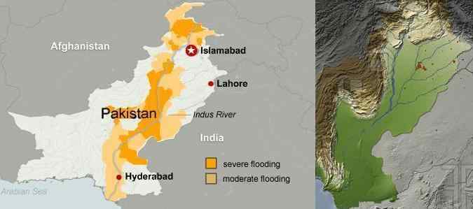
The Indus River is one of the points on the Indian sub-continent that is being pushed under the Himalayas range, as a close look at where the mountain building along the northern edge of the Indo-Australian Plate occurs shows. We have pointed out that the mountains in the interior of India seem to disappear as one approaches the Himalayas, and that this is because it is there that the plate is being pushed down. We have predicted that as the tongue of the Eurasian Plate holding Indonesia is pushed under the eastern edge of the Indo-Australian Plate that this edge will lift, tilting the Indo-Australian Plate down on the western edge. This would first be noticed on land, especially land subject to being flooded, as such a change under the sea would escape notice unless a tsunami buoy sounded an alarm. What should be noted is that the flooding, ostensibly from rains, are worse than anticipated from the rains alone. What should be watched is how well the flood waters drain, and whether a drop in elevation is noted along the Indus River and its outlet into the Indian Ocean. The Earth changes we have predicted for this region have begun!
-----------------------------------------
As the continent of India is pushed steadily down and under the Himalayas, lands in Pakistan that lie on the Indo-Australian Plate will participate. The plate border as it transverses Pakistan reflects this, with the Indus Valley on the Indo-Australian Plate being lowland, and the highlands to the west on the Eurasian Plate. Lahore and eastern Pakistan can thus expect to steadily sink up until the time of the Pole Shift, when it will share the dive that India itself will experience.
ZetaTalk ™ November 5, 2011
Views: 2642
Comment
-
Comment by Khan on August 24, 2013 at 4:54am
-
Thanks Planet Twelve !
Bangladesh: Over 60 villages flooded in Bhola, Hatiya
Aug 21, 2013
High tide under the impact of full moon, coupled with depression, has caused flooding of more than 60 villages in five upazilas of Bhola and Hatiya upazila of Noakhali.
In Bhola, due to the high tide, water of Meghna and Teutulia rivers started to rise from Monday afternoon, reports our correspondent.
When Meghna crossed its danger level yesterday, portions of Bhola-Charfession and Bhola-Laxmipur roads went under water, disrupting communications.
Locals said, water gushing through the breached points of the dyke inundated over 50 villages in Dhania, Kachia, Purbo Ilisha, Rajapur and Bapta unions in Sadar upazila, Sayedpur and Bhabanipur unions of Daulatkhan upazila, Baro Manika, Pokkhia, Hasan Nagar, Kutitsa unions of Borhauddin upazila, Chandpur, Chanchra, Sonapur unions of Tamajuddin upazila and Sakuchia union in Monpura upazila.
Flooding marooned several thousand people in 40 villages while homesteads of many were inundated.
In Hatiya upazila of Noakhali, at least 10 villages were flooded by tidal water as town protection dyke breach at too points yesterday noon, reports our correspondent.
© 2025 Created by 0nin2migqvl32.
Powered by
![]()
You need to be a member of Earth Changes and the Pole Shift to add comments!
Join Earth Changes and the Pole Shift