Mexico: The crack than two thousand meters that formed in Alto Lucero
Nov 18, 2013
The opening expands over 17 acres of land, which are in danger as there have been landslides and subsidence in several areas leaving the rural acfectaciones
Alto Lucero , Veracruz - ( RadioVer / Francisco De Luna ) The crack than two thousand meters that formed in the Providence community , municipality of Alto Lucero , may be the emergence of an underground river , according to the Civil Protection Technical Secretary , Guadalupe Sanchez Ladron de Guevara .
After landslides flocked to the area a group of geologists from the National Autonomous University of Mexico (UNAM ) in coordination with municipal Civil Protection who made data survey .
The opinion is not yet concluded , however so far the data indicate that it is a tributary that runs underground, but for this natural phenomenon continues cracking earth .
The opening expands over 17 acres of land, which are in danger as there have been landslides and subsidence in several areas leaving the rural acfectaciones .
The owner of Municipal Civil Protection , said the Pro-Vicar crack plots they sank more than half a meter and openings of up to nine meters wide , " and has been growing lately," he said during the interview at City Hall in Alto Lucero .
He said that geologists in the version indicates that if the rains continue , the cracks will be larger and even landslides likely , despite the failure occurred just over a month.
Concern that keep the municipal authorities is that the nearest house is located a few hundred yards from the holes of the earth , making it necessary to relocate the family if an emergency occurs .
Guadalupe Sanchez , said the community road sank 30 inches so that the locals chose to try to repair the ramps to travel on the roads .
But fear a landslide occurs as in " El Capulin " Chiconquiaco Township , where a hill dragging broke off trees and water in the town , this past September 2 .
------------------------------------------------------------------------------------
ZetaTalk Chat Q&A for April 30, 2011
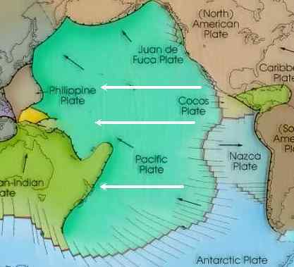
We stated that as a result of the 7 of 10 scenarios that the top of S America would find itself 250 miles further to the west, though not all of this would be due to movement of S America and the Caribbean and Central America. Can we be more specific? We have described the Pacific Plate as being composed of four plates, not one. They are folding over one another, and thus the Pacific compresses. It is primarily the folding of the Mariana Trench with the tilting of the Mariana and Philippine plates that create a significant reduction in the size of the Pacific to allow the S America roll to occur. There will be great coordination of these events during the final sinking in Indonesia and significant rolling of the S America Plate.
What happens to Mexico during this process? Is it left where it is, to find its connection with Central America 250 miles further to the west? When the Mariana and Philippine plates tilt and fold this affects Mexico, which is directly to the east. This portion of the N American continent moves in concert with the S American roll, putting the N American continent under an excruciating bow stress prior to its anticipated New Madrid adjustment. This will be felt primarily in the US southwest and east through Texas, as well as Mexico.
http://www.zetatalk.com/ning/30ap2011.htm
Views: 1746
Comment
© 2025 Created by 0nin2migqvl32.
Powered by
![]()
You need to be a member of Earth Changes and the Pole Shift to add comments!
Join Earth Changes and the Pole Shift