Earth Changes and the Pole Shift
New Madrid
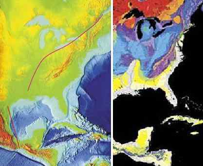
There has been much made of an earthquake in the recent past long the New Madrid fault line, as this was unexpected, being in a quiescent area, and thus raised all manner of questions regarding the possibility of massive earthquakes in areas presumed to be safe. Simply put, there are no earthquake free areas, and during the coming pole shift, all parts of the globe will be subject to them, without exception. Thus, individuals living in areas which have never experienced an earthquake should not presume safety but should take the same steps in preparing for the pole shift that those living atop highly active fault lines take - stay out of old or masonry buildings, and anticipate earthquakes as severe as any that mankind has ever experienced and noted.
ZetaTalk ™
Our description on the pole shift itself describes not a single jolt when the crust stops moving but a series of jolts. Most severe earthquakes are like this, in fact, if one examines their pattern. There are small quakes ahead of time, swarms, and jiggling that unsettles people as they sense something is pending. Then when the rock fingers that are preventing the fault line from sliding or subducting suddenly break, a large jolt. This often, within minutes, results in more jolts as the pressure that was at one point now moves to be pressure at the next point where rock fingers are holding the slippage. Aftershocks result, as yet more rock fingers break, until a point arrives where there is so much resistance to slippage that the quake and its after effects is considered complete.
For the New Madrid, which will include the European tsunami in its effects, there will be one large jolt with a subsequent and almost immediate tearing of the Atlantic. We have stated that the European tsunami will be the largest, but smaller ones will follow in time. Likewise for the New Madrid adjustment, which involve a tearing of the entire N American continent from the seaway down to Mexico. This adjustment will not occur until minor rock fingers have been steadily broken in a number of places. The areas to be affected have already been experiencing quake swarms, buckling roadways, sinkholes, breaking dams, and unsettling jigging which is unexplained by the authorities. When the primary blockage gives, there will be a huge jolt, with little warning. Aftershocks will continue until the time of the pole shift itself.
ZetaTalk ™ 2010
It is known by man that the New Madrid Fault line runs beyond the immediate area of New Madrid. When we stated that "Chicago will rupture and adjust" and "Ohio will be pulled in places" this should not be news to man. The New Madrid runs up along the Seaway, to the mouth of the Seaway, and thus will rupture any land it passes through. Plot its course and consider that more than the fault line itself will be disrupted. Rock detached from its former connections is free to react to the dominant theme in the area. If rock was held down, formerly, it can bounce up. If rock was held back, it is free to spring forward. And adjustment in rock strata means that loose soil will sink or heave. This most certainly can affect a broader area than just the fault line. We have stated that Ohio will be affected most in this regard. These matters are related to the rock strata, which bonds or breaks, as we have stated. There is a natural break in the rock strata holding Ohio, along the Ohio River and into its headwaters, as can be seen. Why should Chicago be affected? There is a natural break in the rock strata between the New Madrid and Chicago also, a weakness, which will rupture with the New Madrid. When the Seaway pulls apart there will be a dropin support formerly present during rock attachments. Chicago has long been predicted, by ourselves and others, to be devastated. Much of the infrastructure will rupture, causing buildings to crumble and freeways to be worthless and irreparable. One need only follow the geology of the region, to predict what will happen.
ZetaTalk ™ 2010
During the 7 of 10 New Madrid adjustment the Seaway will be affected, as we mentioned earlier. It will not tear open to the degree we predicted for the pole shift itself, but weak points along the Seaway will adjust. During the 7 of 10 Duluth will find crevasses nearby, similar to the crevasse that has occurred recently in the Michigan Penninsula, but with greater depth and scope. Inland locks along the Seaway will break. Detroit and Toronto will be unaffected during the 7 of 10 except of course for earthquake damage. As the New Madrid fault line runs up along the Seaway just under the Great lakes in Ohio, cities such as Cleveland and Toledo will find their infrastructure greatly shattered in places as the rock beneath them will jut and drop, vertical adjustments. Buffalo, being virtually on the fault line, will likewise be shattered in this way, such that freeways become useless, but the seaway at Niagara Falls will remain.
ZetaTalk ™ 2010
As both sides of the New Madrid Fault Line are pulled in opposite directions, the entire fault line operates as a slip-slide fault line. In that the land just to the west of the Mississippi River moves the greatest distance, to ease the pressure on the bow currently formed by the N American continent, this creates a void, a stretch zone void, causing the land there to drop, as we have explained. This is the region currently experiencing precursor earthquakes, the region considered the New Madrid region. But the movement is not yet happening, the void not yet being created. Instead, occasional slight slip-slide adjustments are being made, deep within the rock strata, causing minor quake swarms or sympathetic jolts in neighboring areas. The rock fingers are slipping, but not losing their grip.
When the plate tearing starts in earnest, these slip-slide jolts will be huge, and rise up to the magnitude 8-9 range, as we have stated. These quakes will ride up to the bend in the fault line just south of Lake Michigan. Earthquake damage is primarily done when the rock close to the surface is affected, as is known by man. The quality of the rock along the fault line thus affects the shaking and resulting damage to the surface. A glance at a map of the geology of the fault line shows that the rock along the Mississippi at Arkansas and Missouri is younger, laid down by sediment, and tends to fracture broadly, thus relaying earthquake jolts over a vast area. Broad fractures also cause post quake adjustments, so the quake includes rock shuffling, all of which translates to a larger magnitude for the area. Thus, the worst of the New Madrid adjustment will be felt in this area.
The rock strata that hold Illinois and Indiana is older, and more solid. Fracturing of the rock tends to be a single jolt, not the multiple ricocheting jolts that magnify any adjustment in the rock strata experienced by the rock strata in Arkansas and Missouri. The magnitude will still be considered high, perhaps an 8, but the shaking will not last as long, and the damage therefore not as great. Were the bend in the fault line just south of Lake Michigan not at a point where the southeastern part of the US is dropping away from the Seaway, the damage along the Seaway would be much greater. The Equator is expanding in the center of the Atlantic, and has already, by this time, ripped open between S America and Africa. The southeast thus drops toward this void, relieving pressure and friction along the slip-slide in the fault line as it runs under the Seaway.
By the time the New Madrid adjustment reaches the bend, land to the west of the Mississippi has already dropped, pulled away, but this actually puts more pressure on the fault line as it runs under Michigan. This holds, momentarily, while the southeast starts to drop toward the Atlantic Rift, and then pulls apart sharply. Here, beneath Michigan, the jolts will also not last for long, and will also be considered up to magnitude 8. The fault line thence along the Seaway will unzip, along rock strata borders already established. Where stretch zones such as this normally have adjustments that are basically silent, they do much damage. The unzipping creates crevasses and landslides and sinkholes, and when this occurs under cities is devastating. The quakes will be considered much less than magnitude 8 but the damage will be greater, with consequent lost of life and infrastructure. A building that has collapsed because of a large jolt is no different than one that has collapsed because the ground beneath it sank.
As is known, there is a fault line running up along the East Coast of the US that attaches to the New Madrid fault line in the Gulf. Both fault lines touch there, in the Gulf, and when the New Madrid adjusts there is a sympathetic adjustment up along this fault line. During the last New Madrid adjustment, church bells rang in Boston and cracks appeared in buildings in Savannah, GA and Charleston, SC. These changes are caused by earthquakes equivalent to a magnitude 4-5 or less, not serious.
ZetaTalk ™ March 19, 2011

Note New Madrid Sequence commentary.
Note USGS Signals commentary.
Source: New Madrid
Mario Valencia-Rojas
JUST IN - Numerous people trapped inside burning Ergon oil refinery plant in Newell, West Virginia. @disclosetv https://t.me/disclosetv/2595
May 30, 2021
Kojima
* Earthquakes US & Caribbean [2021/05/23 - 05/29]
Search Earthquake Catalog, USGS
https://earthquake.usgs.gov/earthquakes/search/
Geographic Region: [North 54N, South 10N; West 132W, East 56W]
Magnitude: 1.5+
Date & Time (UTC): [Start 2021-05-23 00:00:00; End 2021-05-29 23:59:59]
May 30, 2021
Mario Valencia-Rojas
May 30, 2021
Massive sinkhole of 100 meters in diameter and 20 in depth appears in Santa Maria Zacatepec Puebla,Mexico.
https://m.facebook.com/story.php?story_fbid=3983528308411593&id...
May 31, 2021
Kojima
* Earthquakes US & Caribbean [2021/05/30 - 06/05]
Search Earthquake Catalog, USGS
https://earthquake.usgs.gov/earthquakes/search/
Geographic Region: [North 54N, South 10N; West 132W, East 56W]
Magnitude: 1.5+
Date & Time (UTC): [Start 2021-05-30 00:00:00; End 2021-06-05 23:59:59]
Jun 6, 2021
Kojima
* Earthquakes US & Caribbean [2021/06/06 - 06/12]
Search Earthquake Catalog, USGS
https://earthquake.usgs.gov/earthquakes/search/
Geographic Region: [North 54N, South 10N; West 132W, East 56W]
Magnitude: 1.5+
Date & Time (UTC): [Start 2021-06-06 00:00:00; End 2021-06-12 23:59:59]
Jun 13, 2021
Kojima
* Earthquakes US & Caribbean [2021/06/13 - 06/19]
Search Earthquake Catalog, USGS
https://earthquake.usgs.gov/earthquakes/search/
Geographic Region: [North 54N, South 10N; West 132W, East 56W]
Magnitude: 1.5+
Date & Time (UTC): [Start 2021-06-13 00:00:00; End 2021-06-19 23:59:59]
Jun 20, 2021
Kojima
* Earthquakes US & Caribbean [2021/06/20 - 06/26]
Search Earthquake Catalog, USGS
https://earthquake.usgs.gov/earthquakes/search/
Geographic Region: [North 54N, South 10N; West 132W, East 56W]
Magnitude: 1.5+
Date & Time (UTC): [Start 2021-06-20 00:00:00; End 2021-06-26 23:59:59]
Jun 27, 2021
Kojima
* Earthquakes US & Caribbean [2021/06/27 - 07/03]
Search Earthquake Catalog, USGS
https://earthquake.usgs.gov/earthquakes/search/
Geographic Region: [North 54N, South 10N; West 132W, East 56W]
Magnitude: 1.5+
Date & Time (UTC): [Start 2021-06-27 00:00:00; End 2021-07-03 23:59:59]
Jul 4, 2021
Kojima
* Earthquakes US & Caribbean [2021/07/04 - 07/10]
Search Earthquake Catalog, USGS
https://earthquake.usgs.gov/earthquakes/search/
Geographic Region: [North 54N, South 10N; West 132W, East 56W]
Magnitude: 1.5+
Date & Time (UTC): [Start 2021-07-04 00:00:00; End 2021-07-10 23:59:59]
Jul 11, 2021
Kojima
* Earthquakes US & Caribbean [2021/07/11 - 07/17]
Search Earthquake Catalog, USGS
https://earthquake.usgs.gov/earthquakes/search/
Geographic Region: [North 54N, South 10N; West 132W, East 56W]
Magnitude: 1.5+
Date & Time (UTC): [Start 2021-07-11 00:00:00; End 2021-07-17 23:59:59]
Jul 18, 2021
Kojima
* Earthquakes US & Caribbean [2021/07/18 - 07/24]
Search Earthquake Catalog, USGS
https://earthquake.usgs.gov/earthquakes/search/
Geographic Region: [North 54N, South 10N; West 132W, East 56W]
Magnitude: 1.5+
Date & Time (UTC): [Start 2021-07-18 00:00:00; End 2021-07-24 23:59:59]
Jul 25, 2021
Kojima
* Earthquakes US & Caribbean [2021/07/25 - 07/31]
Search Earthquake Catalog, USGS
https://earthquake.usgs.gov/earthquakes/search/
Geographic Region: [North 54N, South 10N; West 132W, East 56W]
Magnitude: 1.5+
Date & Time (UTC): [Start 2021-07-25 00:00:00; End 2021-07-31 23:59:59]
Aug 1, 2021
Kojima
* Earthquakes US & Caribbean [2021/08/01 - 08/07]
Search Earthquake Catalog, USGS
https://earthquake.usgs.gov/earthquakes/search/
Geographic Region: [North 54N, South 10N; West 132W, East 56W]
Magnitude: 1.5+
Date & Time (UTC): [Start 2021-08-01 00:00:00; End 2021-08-07 23:59:59]
Aug 8, 2021
Howard
Buoy 42409 - 250 miles south of New Orleans in event mode.
Source
Aug 13, 2021
Kojima
* Earthquakes US & Caribbean [2021/08/08 - 08/14]
Search Earthquake Catalog, USGS
https://earthquake.usgs.gov/earthquakes/search/
Geographic Region: [North 54N, South 10N; West 132W, East 56W]
Magnitude: 1.5+
Date & Time (UTC): [Start 2021-08-08 00:00:00; End 2021-08-14 23:59:59]
Aug 15, 2021
Juan F Martinez
Military preparations for the New Madrid Adjustment.
"While fishing on the Mississippi yesterday on the Wisconsin side of the river. 8/16/2021"
Video: Patty Johnston Lee on FB
https://t.me/ZetaTalk_Followers/4763
https://www.facebook.com/groups/707233279324256/posts/4196884167025...
Aug 21, 2021
Willa Rawlings
Re: the Fb video: Why would the Military need Abrams tanks, Paladin Howitzers and other support vehicles, to aid in the aftermath of the New Madrid Adjustment?
Aug 22, 2021
Juan F Martinez
Great question, Willa Rawlings. It could be exercises, or strategic repositioning of equipment to safer zones, or securing the borders, or preparing for Martial Law during the New Madrid adjustment to control any riots or rebellion.
Aug 22, 2021
Kojima
* Earthquakes US & Caribbean [2021/08/15 - 08/21]
Search Earthquake Catalog, USGS
https://earthquake.usgs.gov/earthquakes/search/
Geographic Region: [North 54N, South 10N; West 132W, East 56W]
Magnitude: 1.5+
Date & Time (UTC): [Start 2021-08-15 00:00:00; End 2021-08-21 23:59:59]
Aug 24, 2021
Kojima
* Earthquakes US & Caribbean [2021/08/22 - 08/28]
Search Earthquake Catalog, USGS
https://earthquake.usgs.gov/earthquakes/search/
Geographic Region: [North 54N, South 10N; West 132W, East 56W]
Magnitude: 1.5+
Date & Time (UTC): [Start 2021-08-22 00:00:00; End 2021-08-28 23:59:59]
Aug 29, 2021
Nancy Lieder
https://www.youtube.com/watch?v=R7ryv-TqClk
We have Karst limestone under Minnesota and Wisconsin too, where I live. In fact we have an old bowl shape in a hill stop not a mile from me from a Karst drop. Water washes away the limestone and then BOOM. It appears that the tension in the N American bow is also involved, and that a landslide might be forming here. It is on the line where Lake Superior rips open toward the Black Hills of the Dakotas. The Seaway is pulling apart.
http://www.zetatalk.com/newsletr/issue052.htm
Aug 29, 2021
Juan F Martinez
2 dead, 10 injured after South Mississippi highway collapses following heavy rainfall.
But where's the water? And, coincidentally, the second wave of the New Madrid is in progress and the collapse just happens to be directly above a known seismic fault that happens to be coincidentally connected to the New Madrid Seismic Zone. Hmmm.
https://www.wlox.com/2021/08/31/2-dead-10-injured-george-county-roa...
https://www.wjtv.com/news/mondays-earthquake-in-north-mississippi-c...
https://t.me/ZetaTalk_Followers/5064
Sep 2, 2021
Juan F Martinez
Washington, D.C. Tsunami — ZetaTalk Prediction 2/28/2021: Just as the New York City underground was flooded by a mere 12 foot storm surge when Hurricane Sandy struck, Washington DC can expect far worse when the New Madrid adjustment strikes. DC can expect a 50 foot tsunami along the East Coast, but because tidal bore can be anticipated up the rivers on either side of DC, this will at least triple in places to a 150 foot tide. This will do more than wash the roadways and lower floors of the federal buildings, it will permanently flood the tunnel systems, taking with it all the evidence of Satanic practices – a literal draining of the swamp will occur.
http://poleshift.ning.com/profiles/blogs/zetatalk-newsletter-as-of-...
https://www.facebook.com/groups/351696368562307
https://t.me/ZetaTalk_Followers/5105
Sep 5, 2021
Kojima
* Earthquakes US & Caribbean [2021/08/29 - 09/04]
Search Earthquake Catalog, USGS
https://earthquake.usgs.gov/earthquakes/search/
Geographic Region: [North 54N, South 10N; West 132W, East 56W]
Magnitude: 1.5+
Date & Time (UTC): [Start 2021-08-29 00:00:00; End 2021-09-04 23:59:59]
Sep 5, 2021
Juan F Martinez
In this video captured by Heather Risacher Rooney, you hear the loud boom in Clarksville around 9:50PM last night that police call an “unknown phenomena.” http://bit.ly/3yQWImZ
https://t.me/ZetaTalk_Followers/5193
Mysterious 'Unknown Phenomena' Caused Loud Explosion, Ground To Sha...
Sep 8, 2021
Kojima
* Earthquakes US & Caribbean [2021/09/05 - 09/11]
Search Earthquake Catalog, USGS
https://earthquake.usgs.gov/earthquakes/search/
Geographic Region: [North 54N, South 10N; West 132W, East 56W]
Magnitude: 1.5+
Date & Time (UTC): [Start 2021-09-05 00:00:00; End 2021-09-11 23:59:59]
Sep 12, 2021
Juan F Martinez
Detroit, Michigan Road buckles in southwest Detroit; DTE, water officials responding. Officials are investigating an area where part of a road buckled and an odor was present in southwest Detroit over the weekend. Details on the incident were limited Sunday afternoon, with DTE stating that no natural gas explosion occurred, but that DTE infrastructure had been impacted by a water main break. Meanwhile, the Great Lakes Water Authority, or GLWA, reported that a gas explosion of some kind had taken place and caused a water main break.
https://www.msn.com/en-us/news/us/road-buckles-in-southwest-detroit...
https://t.me/ZetaTalk_Followers/5329
Sep 13, 2021
Juan F Martinez
Detroit — U.S. Rep. Rashida Tlaib and a coalition of Detroit-area politicians are asking city officials to evacuate residents of southwest Detroit who live near the site of an underground event that displaced gas and water lines as well as damaged buildings last week.
The politicians said it is unclear whether conditions are safe for residents near the site at the corner of Dearborn and W. Fort streets, where the provisioning center Stash Detroit was severely damaged in the Saturday night event. The building was demolished Tuesday.
"There's too many unanswered questions for us to stand still and wait until this community is wiped out because people were negligent," Tlaib argued during a press conference Friday at Trinity-St Mark's United Church, near the scene. "...The fact the ground is shaking alone should sound the alarms. What is the evacuation plan?"
https://www.detroitnews.com/story/news/local/detroit-city/2021/09/1...
Sep 19, 2021
Kojima
* Earthquakes US & Caribbean [2021/09/12 - 09/18]
Search Earthquake Catalog, USGS
https://earthquake.usgs.gov/earthquakes/search/
Geographic Region: [North 54N, South 10N; West 132W, East 56W]
Magnitude: 1.5+
Date & Time (UTC): [Start 2021-09-12 00:00:00; End 2021-09-18 23:59:59]
Sep 19, 2021
Kojima
* Earthquakes US & Caribbean [2021/09/19 - 09/25]
Search Earthquake Catalog, USGS
https://earthquake.usgs.gov/earthquakes/search/
Geographic Region: [North 54N, South 10N; West 132W, East 56W]
Magnitude: 1.5+
Date & Time (UTC): [Start 2021-09-19 00:00:00; End 2021-09-25 23:59:59]
Sep 26, 2021
Kojima
* Earthquakes US & Caribbean [2021/09/26 - 10/02]
Search Earthquake Catalog, USGS
https://earthquake.usgs.gov/earthquakes/search/
Geographic Region: [North 54N, South 10N; West 132W, East 56W]
Magnitude: 1.5+
Date & Time (UTC): [Start 2021-09-26 00:00:00; End 2021-10-02 23:59:59]
Oct 3, 2021
Kojima
* Earthquakes US & Caribbean [2021/10/03 - 10/09]
Search Earthquake Catalog, USGS
https://earthquake.usgs.gov/earthquakes/search/
Geographic Region: [North 54N, South 10N; West 132W, East 56W]
Magnitude: 1.5+
Date & Time (UTC): [Start 2021-10-03 00:00:00; End 2021-10-09 23:59:59]
Oct 10, 2021
Kojima
* Earthquakes US & Caribbean [2021/10/10 - 10/16]
Search Earthquake Catalog, USGS
https://earthquake.usgs.gov/earthquakes/search/
Geographic Region: [North 54N, South 10N; West 132W, East 56W]
Magnitude: 1.5+
Date & Time (UTC): [Start 2021-10-10 00:00:00; End 2021-10-16 23:59:59]
Oct 17, 2021
M. Difato
Stretch Zone becoming Obvious in Syracuse New York.
https://www.syracuse.com/news/2021/10/toppled-trees-cracked-basemen...
Syracuse residents confront a mystery: What’s behind the sinkholes and falling trees?
Syracuse, N.Y. – The first omen in the North Valley neighborhood was the mysterious tilting and toppling of tall, mature trees.
Then craters developed in once-smooth lawns. Cracks spidered cross basement floors; water seeped in. A kitchen and adjoining deck leaned precariously. A house foundation shifted, opening a gap big enough for a pit bull to crawl in. A 12-foot-deep sinkhole suddenly gaped.."
Oct 21, 2021
Kojima
* Earthquakes US & Caribbean [2021/10/17 - 10/23]
Search Earthquake Catalog, USGS
https://earthquake.usgs.gov/earthquakes/search/
Geographic Region: [North 54N, South 10N; West 132W, East 56W]
Magnitude: 1.5+
Date & Time (UTC): [Start 2021-10-17 00:00:00; End 2021-10-23 23:59:59]
Oct 24, 2021
Kojima
* Earthquakes US & Caribbean [2021/10/24 - 10/30]
Search Earthquake Catalog, USGS
https://earthquake.usgs.gov/earthquakes/search/
Geographic Region: [North 54N, South 10N; West 132W, East 56W]
Magnitude: 1.5+
Date & Time (UTC): [Start 2021-10-24 00:00:00; End 2021-10-30 23:59:59]
Oct 31, 2021
Kojima
* Earthquakes US & Caribbean [2021/10/31 - 11/06]
Search Earthquake Catalog, USGS
https://earthquake.usgs.gov/earthquakes/search/
Geographic Region: [North 54N, South 10N; West 132W, East 56W]
Magnitude: 1.5+
Date & Time (UTC): [Start 2021-10-31 00:00:00; End 2021-11-06 23:59:59]
Nov 7, 2021
Kojima
* Earthquakes US & Caribbean [2021/11/07 - 11/13]
Search Earthquake Catalog, USGS
https://earthquake.usgs.gov/earthquakes/search/
Geographic Region: [North 54N, South 10N; West 132W, East 56W]
Magnitude: 1.5+
Date & Time (UTC): [Start 2021-11-07 00:00:00; End 2021-11-13 23:59:59]
Nov 14, 2021
Kojima
* Earthquakes US & Caribbean [2021/11/14 - 11/20]
Search Earthquake Catalog, USGS
https://earthquake.usgs.gov/earthquakes/search/
Geographic Region: [North 54N, South 10N; West 132W, East 56W]
Magnitude: 1.5+
Date & Time (UTC): [Start 2021-11-14 00:00:00; End 2021-11-20 23:59:59]
Nov 21, 2021
Kojima
* Earthquakes US & Caribbean [2021/11/21 - 11/27]
Search Earthquake Catalog, USGS
https://earthquake.usgs.gov/earthquakes/search/
Geographic Region: [North 54N, South 10N; West 132W, East 56W]
Magnitude: 1.5+
Date & Time (UTC): [Start 2021-11-21 00:00:00; End 2021-11-27 23:59:59]
Nov 28, 2021
Juan F Martinez
NEW MADRID ADJUSTING NOW
New Madrid, Missouri Region
Earthquake Summary
to Memphis: 155 km, 197°
Mag 2.0++++
Depth 8km
Time (UTC)2021-11-29 03:47:50
Location36.5° N 89.6° W
New Madrid, Missouri Region
to Memphis: 145 km, 200°
Mag 2.3++++
Depth 8km
Time (UTC)2021-11-28 23:03:30
Location36.4° N 89.5° W
New Madrid, Missouri Region
to Memphis: 117 km, 197°
Mag 2.1++++
Depth 7km
Time (UTC)2021-11-26 01:39:40
Location36.2° N 89.7° W
New Madrid, Missouri Region
to Memphis: 174 km, 195°
Mag 1.8++++
Depth 7km
Time (UTC)2021-11-24 11:10:42
Location36.7° N 89.5° W
New Madrid, Missouri Region
Mag 1.3++++
Depth 8km
Time (UTC)2021-11-22 23:54:57
Location 36.4° N 89.5° W
https://poleshift.ning.com/profiles/blogs/new-madrid
https://stationview.raspberryshake.org/
Nov 29, 2021
Juan F Martinez
New Madrid Ramifications and Consequences
https://t.me/ZetaTalk_Followers/7155
https://poleshift.ning.com/profiles/blogs/new-madrid
Dec 3, 2021
Juan F Martinez
Why Earthquakes in the East are so much more Dangerous
https://youtu.be/Kn2KFC8cX-g
https://poleshift.ning.com/profiles/blogs/new-madrid
Dec 4, 2021
Kojima
* Earthquakes US & Caribbean [2021/11/28 - 12/04]
Search Earthquake Catalog, USGS
https://earthquake.usgs.gov/earthquakes/search/
Geographic Region: [North 54N, South 10N; West 132W, East 56W]
Magnitude: 1.5+
Date & Time (UTC): [Start 2021-11-28 00:00:00; End 2021-12-04 23:59:59]
Dec 5, 2021
Mario Valencia-Rojas
4.3+4=(((8 3)))
4.3 mg Saline County, Kansas 12-08-2021 UTC
8 Dec 2021 13:45:28 UTC
8 Dec 2021 07:45:28 near epicenter
8 Dec 2021 08:45:28 EST
Location 38.655N 97.446W
Depth 3 km
5.8 km (3.6 mi) SSW of Gypsum, Kansas
25.1 km (15.5 mi) SE of Salina, Kansas
36.9 km (22.8 mi) NNE of McPherson, Kansas
67.6 km (41.9 mi) SW of Junction City, Kansas
159.6 km (98.9 mi) WSW of Topeka, Kansas
https://t.me/ZetaTalk_Followers/7259
Dec 8, 2021
Kojima
* Earthquakes US & Caribbean [2021/12/05 - 12/11]
Search Earthquake Catalog, USGS
https://earthquake.usgs.gov/earthquakes/search/
Geographic Region: [North 54N, South 10N; West 132W, East 56W]
Magnitude: 1.5+
Date & Time (UTC): [Start 2021-12-05 00:00:00; End 2021-12-11 23:59:59]
Dec 12, 2021
Mario Valencia-Rojas
3.0+4.0=(((7.0)))
3.0 mg Miami County, Ohio 12-12-2021 UTC
12 Dec 2021 17:52:56 UTC
12 Dec 2021 12:52:56 near epicenter
12 Dec 2021 12:52:56 EST
Location 38.703N 83.581W
Depth 11 km
New Madrid Adjustment under microscope
https://poleshift.ning.com/m/blogpost?id=3863141%3ABlogPost%3A487732
NewMadrid
https://poleshift.ning.com/m/blogpost?id=3863141%3ABlogPost%3A1100309
https://www.facebook.com/groups/351696368562307/permalink/154023646...
Dec 12, 2021
Mario Valencia-Rojas
5.7+4 = (((9.7)))
M 5.7 - 5 km S of El Pacayal, Mexico
2021-12-13 07:03:08 (UTC)
15.552°N 92.044°W
180.1 km depth
NewMadrid Unzipping but a moment away
http://www.zetatalk.com/ning/31de2021.htm
http://www.zetatalk.com/ning/30no2021.htm
https://www.facebook.com/groups/351696368562307/permalink/154066780...
Dec 13, 2021
Kojima
* Earthquakes US & Caribbean [2021/12/12 - 12/18]
Search Earthquake Catalog, USGS
https://earthquake.usgs.gov/earthquakes/search/
Geographic Region: [North 54N, South 10N; West 132W, East 56W]
Magnitude: 1.5+
Date & Time (UTC): [Start 2021-12-12 00:00:00; End 2021-12-18 23:59:59]
Dec 19, 2021
Mario Valencia-Rojas
New Madrid Adjusting!Big New Madrid Adjustment but a moment away!
2.0+4=((6.0)) 2.3+4=((6.3)) 2.6+4=((6.6))
3 earthquakes, Tennessee & Kentucky 12-23-2021 UTC
---
2.0 mg Greene County, Tennessee 12-23-2021 UTC
23 Dec 2021 05:36:27 UTC
23 Dec 2021 00:36:27 near epicenter
23 Dec 2021 00:36:27 EST
Location 36.272N 82.936W
Depth 0 km
9.3 km (5.8 mi) NNE of Mosheim, Tennessee
15.3 km (9.5 mi) NW of Greeneville, Tennessee
32.9 km (20.4 mi) E of Morristown, Tennessee
45.5 km (28.2 mi) SW of Kingsport, Tennessee
258.0 km (159.9 mi) SSW of Charleston, West Virginia
---
2.3 mg Breathitt County, Kentucky 12-23-2021 UTC
23 Dec 2021 08:32:58 UTC
23 Dec 2021 03:32:58 near epicenter
23 Dec 2021 03:32:58 EST
Location 37.643N 83.233W
Depth 9 km
16.6 km (10.3 mi) NE of Jackson, Kentucky
91.9 km (57.0 mi) ESE of Winchester, Kentucky
94.3 km (58.5 mi) E of Berea, Kentucky
94.4 km (58.5 mi) E of Richmond, Kentucky
157.0 km (97.3 mi) ESE of Frankfort, Kentucky
---
2.6 mg Pike County, Kentucky 12-23-2021 UTC
23 Dec 2021 10:29:00 UTC
23 Dec 2021 05:29:00 near epicenter
23 Dec 2021 05:29:00 EST
Location 37.569N 82.565W
Depth 17 km
6.3 km (3.9 mi) N of Coal Run Village, Kentucky
94.5 km (58.6 mi) S of Meads, Kentucky
94.9 km (58.9 mi) S of Huntington, West Virginia
99.1 km (61.4 mi) S of Ironville, Kentucky
119.3 km (73.9 mi) SW of Charleston, West Virginia
---
NewMadrid
https://poleshift.ning.com/m/blogpost?id=3863141%3ABlogPost%3A1100309
Dec 23, 2021