Earth Changes and the Pole Shift
Volcano watch
Benevolent extraterrestrials monitoring volcanoes to provide early warning to human partners.
Volcanic activity worldwide 18 October, 2025: Kilauea in Hawaii, Santiaguito volcano, Fuego, Semeru, Ibu, Dukono, Reventador, and soon "all volcanoes that have been active within the memory of man will begin spewing and burping and oozing, and many that were not expected to become active will reactive."
"Of course, all volcanoes will explode, as this is going to be a very severe pole shift. What about the months and years preceding the pole shift? It is no secret that Mammoth Lake and the caldera of Yellowstone are warming up, and the populace has been prepared for these occurrences by the movie Volcano where there, in the middle of LA, lava is bubbling up. In fact, there is a fault line running from the approximate San Diego/LA area, up into the Sierras, and this is liable to rupture rather violently during one of the quakes that precedes the pole shift by some months. Volcanic eruptions from that area in the Sierras can be expected. Will Mount St. Helen erupt? All volcanoes that have been active within the memory of man will begin spewing and burping and oozing, and many that were not expected to become active will reactive." ZetaTalk - Feb 15, 2000
Recall 15
#Pacaya's volcano. The lava flow from the northeast flank continues its advance in a west and south-west direction, in the area known as La Breña.
Activity in the new fissure can be observed from the webcam:
Via:
https://twitter.com/ConredGuatemala
May 1, 2021
Juan F Martinez
Apocalyptic skies after massive eruption in the ICELAND, May 2. @MyBeauDes
https://watchers.news/.../huge-lava-fountains-at.../
May 3, 2021
Juan F Martinez
ECUADOR Volcanic Ash from Sangay volcano - Happening now.
Posted by Carlos Juan Semidey on ZTF.
https://www.facebook.com/carlosjuan.semidey
May 8, 2021
KM
https://www.dailymail.co.uk/news/article-9608391/Volcano-erupts-Con...
Volcano erupts in the Congo spewing red fumes into the night sky and sending residents fleeing for their lives into neighbouring Rwanda
A volcano has erupted in the Democratic Republic of Congo, spewing red fumes into the night sky and sending residents fleeing for their lives into neighbouring Rwanda.
People frantically grabbed mattresses and other belongings and fled towards the frontier, while power was cut and phone lines were jam-packed in large parts of Goma.
Despite the panic caused by the eruption of the Nyiragongo at around 7pm, a volcanologist said the city did not appear to be in danger.
A United Nations source said a reconnaissance flight by a U.N. helicopter appeared to show lava was not flowing towards Goma or any major population centres.
The military governor of North Kivu province, General Constant Ndima, appealed for calm, saying: 'Investigations are underway and people must follow the guidance of civil protection units'.
The volcano sits in the country's Virunga National Park, which is also home to endangered mountain gorillas.
The Mount Nyiragongo volcano erupted on Saturday, spewing red fumes into the night sky over the Democratic Republic of Congo's eastern city of Goma and sparking an exodus to neighbouring Rwanda
The eruption has turned the sky red over the city of Goma, in the Democratic Republic of Congo
A Congolese woman, carrying possessions on her head, flees from Mount Nyiragongo volcano as it erupts over Goma
A general view shows smoke and flames of the volcanic eruption near Goma, Democratic Republic of Congo
'The sky has turned red,' one resident, Carine Mbala, told AFP by telephone.
'There is a smell of sulphur. In the distance you can see giant flames coming out of the mountain.
'But there has not been any earthquake,' she added.
'People are leaving or preparing to leave,' another resident told AFP, as the streets began filling up, some carrying as many of their belongings as they could.
'The people are leaving or preparing to leave,' an inhabitant said.
'I am taking the children and getting into the car. There is a risk that the lava will flow on Goma,' another said.
But for the moment, there is no sign of a flow of lava from the city, the correspondent said.
But the last time Nyiragongo erupted was January 17, 2002, killing more than a hundred people and covering almost all of the eastern part of Goma with lava, including half of the airport's landing strip.
Hundreds of thousands fled the city.
The deadliest eruption of the 3,000-metre high volcano was in 1977, when more than 600 died.
Volcanologists at the Goma Volcano Observatory, which monitors Nyiragongo, have struggled to make basic checks on a regular basis since the World Bank cut funding amid embezzlement allegations.
In a bulletin on May 10, the observatory said there had been increased seismic activity at Nyiragongo earlier in the month.
Goma sits on the mountain's southern flank and overlooks Lake Kivu.
The Goma region, which lies in North Kivu province, bordering Rwanda and Uganda, has six volcanoes, all higher than 3,000 metres.
May 23, 2021
Juan F Martinez
INDONESIA — Mount Sinabung Volcano has another powerful explosion, on the island of Sumatra. Credit: Andy Pratama Tarigan, 7/27/2021
https://t.me/ZetaTalk_Followers/4133
Jul 28, 2021
Howard
Snapshot of how explosive volcanic activity has increased dramatically over the past decade. A typical past few days this year versus what was typical over 9 days in 2012.
2012 Link - "There has not been happening much in the volcano world...
2021 Link
Sep 17, 2021
jorge namour
La Palma in the Canaries
https://www.facebook.com/Ilmondodeiterremoti/
https://www.facebook.com/Ilmondodeiterremoti/videos/196607105899628
BREAKING: The Canary Islands Volcanological Institute (INVOLCAN) has just confirmed and officialized the start of the volcanic eruption on the island of La Palma, in the Canary Islands. Everything is happening in real time as a result it's very difficult to get details about the beginning of the eruption.
For the moment we know that a plume of ash and gas has risen by several hundred meters high. It seems, from some images, that the eruptive fracture that opened along one of the mountains of the island is producing small lava fountains.
An emergency evacuation has been underway for about an hour!
We keep you posted.
Sep 19, 2021
Recall 15
Lava Flow on la Palma, Canary Island, going into houses:
Captured Image:
From video Link:
https://www.youtube.com/watch?v=eGebfo8c68c
Sep 20, 2021
Juan F Martinez
Watching the La Palma volcanic eruption from the other side of the island (Roque de los Muchachos). Picture: Kike_Infoto
https://strangesounds.substack.com/p/they-are-clearly-manipulating-...
Sep 23, 2021
Tracie Crespo
https://www.reuters.com/world/us/hawaiis-kilauea-volcano-erupting-f...
Hawaii's Kilauea volcano erupting in 'full swing' - USGS
General view of lava surfacing on the Halema'uma'u crater of Kilauea volcano in Kilauea, Hawaii, U.S. September 29, 2021, in this still image provided by the USGS surveillance camera. Mandatory credit USGS/via REUTERS
Sept 30 (Reuters) - Hawaii's Kīlauea volcano was erupting in "full swing" late on Wednesday, the U.S. Geological Survey (USGS) said, with local media reporting that the eruption posed no immediate danger to residents.
"What was once a cooling lava lake is now a new fissure eruption," USGS Volcanoes said in a tweet.
The U.S. Geological Survey Hawaiian Volcano Observatory (HVO) elevated Kīlauea's volcano alert level from "WATCH" to "WARNING" and its aviation color code from "ORANGE" to "RED" as the new eruption and associated hazards are evaluated, USGS said.
The latest alert level and color code imply that a hazardous eruption is "imminent, underway or suspected", according to the USGS website.
Sep 30, 2021
Juan F Martinez
Live Cam
Volcano on Spain’s Canary Island of La Palma erupts
https://www.msn.com/en-us/weather/topstories/volcano-on-spain-s-can...
Oct 10, 2021
Yvonne Lawson
Mt. Aso in southwest Japan erupts, climbers evacuate
Smoke and ash are seen during an eruption on Mount Aso, a volcano in Kumamoto, Kyushu, Japan October 20, 2021, in this still image obtained from video. Courtesy of Twitter @ NINJA250_NBYK / Social Media via REUTERS
An eruption was observed Wednesday at Mt. Aso in southwestern Japan, prompting four climbers to walk off the volcano, authorities said Tuesday.
The eruption occurred at 11:43 a.m. at the No. 1 Nakadake crater, according to the Japan Meteorological Agency. Mt. Aso's volcanic alert level was raised to 3 on a scale of 5, with people urged not to approach the mountain.
In Tokyo, Chief Cabinet Secretary Hirokazu Matsuno told reporters that no injuries have been reported so far and that local authorities are working to determine whether there are any climbers still on the mountain.
Volcanic ash has blown more than one kilometer from the crater and reached a height of about 3,500 meters, the agency said.
The latest eruption came after a small-scale one on Thursday.
Sources: https://english.kyodonews.net/news/2021/10/fcaf30350266-urgent-mt-a...
https://www.reuters.com/world/asia-pacific/japans-mount-aso-erupts-...
Link to live stream: https://youtu.be/IygHkBsFUk4
Link to initial eruption: https://www.youtube.com/watch?v=uTg-ych6c_0
Oct 20, 2021
Juan F Martinez
Sao Paulo, Brazil Volcano wakes up near Brazil's largest city.
https://t.me/ZetaTalk_Followers/6744
Nov 12, 2021
KM
https://watchers.news/2021/12/04/semeru-volcano-eruption-indonesia-...
High-level eruption at Semeru volcano, ash to 15.2 km (50 000 feet) a.s.l., Indonesia
A high-level eruption took place at Semeru volcano, East Java, Indonesia at around 07:00 UTC on December 4, 2021. The Aviation Color Code was raised to Red.
At 09:20 UTC, the ash cloud was estimated rising up to 15.2 km (50 000 feet) above sea level, according to the Darwin VAAC VA Advisory released at 09:48 UTC.1
"Volcanic ash observed on latest RGB and Visible satellite imagery moving SW of the summit. Ash seems to have detached from the summit and continues to move SW. IR temperature of -85 °C (-121 °F) obtained correspond to 15.2 km (50 000 feet) a.s.l."
Ash has reportedly completely blocked out the Sun over the area.
Some users on social media are reporting fast-flowing lahars.
Dec 4, 2021
Yvonne Lawson
Tonga issues Tsunami warning after undersea volcano in the Pacific erupts sending ash 12miles into sky as four-foot waves smash into island nation
Dramatic official aerial maps showed the eruption cloud over Tonga after the Hunga-Tonga-Hunga-Ha'apai volcanco erupted (pictured, satellite images of the volanic eruption in the Pacific Ocean on Saturday)
'A 1.2 metre tsunami wave has been observed at Nukualofa,' Australia's Bureau of Meteorology tweeted. The maximum tsunami wave recorded following Friday's explosion was 30 centimetres.
The Tonga Meteorological Services said the tsunami warning was in effect for all of Tonga.
The eruption was so intense it was heard as 'loud thunder sounds' in Fiji more than 500 miles away, officials in Suva said.
Authorities in Fiji also issued a warning, telling people to avoid the shoreline due to strong currents and dangerous waves.
Victorina Kioa of the Tonga Public Service Commission said Friday that people should 'keep away from areas of warning which are low-lying coastal areas, reefs and beaches.'
The head of Tonga Geological Services Taaniela Kula urged people to stay indoors, wear a mask if they were outside and cover rainwater reservoirs and rainwater harvesting systems.
The Pacific Tsunami Warning Centre issued a 'tsunami advisory' for American Samoa, saying there was a threat of 'sea level fluctuations and strong ocean currents that could be a hazard along beaches.'
A tsunami has struck Tonga sending terrified locals fleeing for high ground as huge waves crashed over roads and into homes (pictured, tsunami waves begin to overwhelm coastal homes in Tonga on Saturday)
Earlier, the Matangi Tonga news site reported that scientists had observed massive explosions, thunder and lightning near the volcano after it started erupting Friday.
The site said satellite images showed a three-mile-wide plume of ash, steam and gas rising about 12 miles into the air.
More than 1,400 miles away in New Zealand, officials warned of storm surges from the eruption.
Read more : https://www.dailymail.co.uk/news/article-10405447/Tonga-issues-tsun...
Jan 15, 2022
Juan F Martinez
Volcanic activity worldwide 1 May 2022: Semeru volcano, Reventador, Pavlof, Nevado del Ruiz, Sabanca...
https://www.volcanodiscovery.com/volcano-activity/news/179348/Volca...
May 2, 2022
jorge namour
VOLCANO ETNA
ITALY REGION MAY 29 2022
https://www.facebook.com/Ilmondodeiterremoti/videos/1789566248101423
A new eruptive fracture has opened in the upper part of Etna.
During this morning a new eruptive fracture has opened in the upper part of the Bove Valley of Etna, a particular completely uninhabited area of the volcanic building where most of the lava flow ends at taken by the volcano’s top craters. The new fracture opened at an altitude of about 2,800 feet and is fueling a small lava flow that is slowly expanding across the upper valley.
The opening of this new fracture came after yesterday the volcanic tremor levels suffered a significant decrease which was accompanied by the cessation of the Strombolian activity that was ongoing in the part and summit of the southeast crater from last May 12th, the day it was the effusive eruption has started, attracting many tourists and curious locals.
May 29, 2022
Recall 15
Fuego Volcano Eruption 07/04/2022:
The Fuego Volcano increased its eruptive activity on the morning of Monday, July 4, and strong explosions, lava flow and pyroclastic flow are reported in the La Ceniza canyon, reported the National Institute of Seismology, Volcanology, Meteorology and Hydrology (Insivumeh).
In the Special Volcanological Bulletin BEFGO 56-2022, the Insivumeh reports an increase in the eruptive activity of the colossus.
From Direct Link:
https://www.prensalibre.com/guatemala/comunitario/volcan-de-fuego-a...
Jul 4, 2022
jorge namour
ICELAND REGION
New eruption at Fagradalsfjall. AUGUST 3 2022
https://www.facebook.com/volcanochaser/videos/1117030022183624
Aug 4, 2022
Tracie Crespo
https://www.volcanodiscovery.com/stromboli/news/193900/Stromboli-vo...
https://youtu.be/0dVJPowJjJA
Stromboli volcano (Eolian Islands, Italy): destabilization of crater rim released massive pyroclastic density current and lava flow
The ongoing highly elevated activity at the volcano resulted in a spectacular, billowing pyroclastic flow tumbling down the Sciara del Fuoco this morning at about 07:20 local time.
INGV volcanologists concluded that a part of the rim of the crater (likely North)had collapsed that culminated in hot rock falls traveling beyond the coastline above water for about several dozens-to-hundred meters. Ash plumes separating from the flow (so-called phoenix clouds) rose several hundred meters above the volcano. The pyroclastic flow triggered 2 cm high sea waves registered by the tsunami warning system.
The event has been associated with a new lava flow as well, emerging from a vent in the summit area and simultaneously descending with the pyroclastic density current and pouring into the sea.
Oct 9, 2022
Tracie Crespo
https://www.khq.com/news/loud-boom-shakes-post-falls-area-cause-und...
Mount Semeru: Indonesia raises alert to highest level as volcano erupts on Java island
Indonesia's Mount Semeru volcano has erupted, sending ash billowing into the sky and sparking evacuations on the country's main island, Java.
Authorities raised the volcano's warning status to the highest level, meaning its activity had escalated.
No injuries have been reported but nearly 2,000 people were evacuated from the area around the volcano.
People have been urged to keep at least 8 km (5 miles) away, as "hot avalanches" of lava poured from Semeru.
The organization said a bridge being rebuilt after a previous eruption had been badly damaged.
At least six villages had been affected, it added.
Videos of the event showed the sky turning black as a massive plume of ash blocked the sunlight.
Japan issued a tsunami warning for its southernmost islands after the eruption, but meteorologists said no tidal changes had been observed.
Mount Semeru, in East Java province, began erupting at about 02:46 local time (19:46 GMT), authorities said.
Indonesia sits on the Pacific "Ring of Fire" where tectonic plates collide, causing frequent volcanic activity as well as earthquakes.
Semeru - also known as "The Great Mountain" - is the highest volcano in Java at 3,676m (12,060ft) and one of the most active. Its last erupted exactly one year ago, killing at least 50 people and leaving streets filled with mud and ash.
The eruption also follows a series of earthquakes on the west of Java island, located about 640 km (400 miles) east of Indonesia's capital Jakarta, including one last month that killed more than 300 people.
Dec 4, 2022
Juan F Martinez
Mount Etna Smoke Rings
https://twitter.com/ZT_Followers/status/1607452888590356480
Dec 26, 2022
SongStar101
Never-before-seen volcanic magma chamber discovered deep under Mediterranean, near Santorini
Using a technique to study seismic waves, researchers revealed a previously unknown magma chamber underneath a the Kolumbo submarine volcano.
A submarine volcano whose deadly eruption shattered the picturesque Greek island of Santorini nearly 400 years ago has a growing, never-before-seen magma chamber that could fuel another massive eruption within the next 150 years, a new study finds.
About 4 miles (7 kilometers) from Santorini, 1,640 feet (500 meters) under the ocean's surface, lies the Kolumbo volcano. Kolumbo is one of the most active submarine volcanoes in the world, and according to historical accounts (opens in new tab), its last eruption in A.D. 1650 killed at least 70 people. A study published Oct. 22, 2022, in the journal Geochemistry, Geophysics, Geosystems (opens in new tab) revealed that the previously undetected magma chamber growing beneath the Kolumbo volcano could lead to another eruption, thus endangering residents and tourists on Santorini.
Undersea volcanoes are monitored just like their on-land counterparts, but because undersea seismometers are challenging to install, there are fewer of them, which means scientists have less data on undersea volcanoes. In an attempt to overcome this problem, researchers decided to try a different technique to study the inner mechanics of Kolumbo.
Data from the seismic recordings showed a significant decrease in velocity underneath the volcano, indicating the presence of a magma chamber, rather than just solid rock. Further calculations revealed that the magma chamber has been growing at a rate of 141 million cubic feet (4 million cubic meters) per year ever since its eruption in 1650.
The chamber now holds roughly a third of a cubic mile (1.4 cubic km) of magma, the team found.
According to study first author Kajetan Chrapkiewicz (opens in new tab), a geophysicist at Imperial College London, the volume of magma could reach roughly half a cubic mile (2 cubic km) within the next 150 years. That was the estimated amount of magma Kolumbo ejected nearly 400 years ago.
Jan 29, 2023
Tracie Crespo
https://www.msn.com/en-us/news/world/deadliest-volcano-in-western-h...
Deadliest volcano in Western Hemisphere shows signs of increased activity
BOGOTA, Colombia – Experts say a volcano responsible for causing one of the largest disasters in the Western Hemisphere is showing signs of increased activity, which has forced the Colombian government to issue evacuations in the potential impact zone.
The Nevado del Ruiz volcano sits about 80 miles west of Bogotá, and according to Colombia’s Geological Survey, an earthquake swarm has increased to levels not seen since a disastrous eruption in the 1980s killed at least 25,000 people.
Authorities have raised the alert level to orange – the second-highest on a four-stage scale.
A recent update posted by the Global Volcanism Program said on March 30 some 11,600 earthquakes were detected, and the movement of underground fluid was likely responsible for increased ash emissions.
An estimated 57,000 people live in municipalities close to the volcano, and the population has only increased since the Armero tragedy caught thousands off guard on November 13, 1985.
According to the U.S. Geological Survey, the last major eruption occurred during a time of major political discourse, and the nighttime event was obscured by a significant storm.
"Within minutes, 23,000 people - most of the town’s inhabitants - were killed, entombed within a concrete-like mixture of mud, vegetation, buildings, and everything else swept away by the lahars. Sadly, the lahars reached Armero approximately two hours after the eruption - plenty of time for the people to have evacuated to higher ground, had they been notified more quickly," the USGS recounted.
President Gustavo Petro has encouraged people in the potential impact zone to evacuate and has asked authorities to hasten their response.
"We have asked the Departmental Risk Councils to speed up the preventive evacuation of 2,500 families that are at high risk due to the contingency of Nevado del Ruiz," Petro said in a statement.
According to Colombian officials, there have been 18 orange alerts since 1985, with none leading to a major eruption.
Volcanologists compare the Nevado del Ruiz to Washington’s Mount St. Helens. Both volcanoes are capable of explosive eruptions and dangerous mudflows that swallow everything in their path.
Apr 8, 2023
Juan F Martinez
The increased activity of the volcano has Popocatépetl been detected by Sentinel-5P. Here is the map showing the plume of SO2 emissions currently measured from space.
ZetaTalk Prediction: "All volcanoes that have been active within the memory of man will begin spewing and burping and oozing, and many that were not expected to become active will reactive."
ZetaTalk - Feb 15, 2000
https://poleshift.ning.com/profiles/blogs/volcano-watch
https://t.me/ZetaTalk_Followers/30330
Apr 27, 2023
Tracie Crespo
https://www.msn.com/en-us/weather/topstories/colombia-urges-evacuat...
Colombia urges evacuation near deadly volcano after increase in seismic activity
Authorities in Colombia on Saturday recommended that towns closest to a rumbling, notorious volcano be evacuated, ahead of a possible eruption.
The Disaster Risk Management Office said it was moving to evacuate communities that are located within 15 kilometers (nine miles) from the main crater of three that make up the Nevado del Ruiz volcano in the Colombian Andes.
Seismic activity has increased at the volcano, which killed 25,000 people in an eruption in 1985.
That blast was the worst natural disaster in Colombian history and one of the deadliest volcanic eruptions of the 20th century.
There has recently been a "significant increase in seismic activity," the ministry of mines said in a statement while Colombia's SGC geological service warned of a "probable eruption within days or weeks."
The 5,300-meter (17,400-foot) colossus in western Colombia is one of the many volcanoes along the Ring of Fire, a path around the Pacific basin characterized by active volcanoes and frequent earthquakes.
On November 13, 1985, it erupted and emitted so much heat that it melted the snow that caps the mountain.
This triggered a cascading wall of mud that swallowed the town of Armero, killing half its population of 50,000.
Apr 30, 2023
Juan F Martinez
MEXICO: Popocatépetl volcanic activity puts area on high alert.
Given the intense activity of the Popocatepetl Volcano, the army is already preparing more than 3000 vehicles in case of evacuation.
https://mexiconewsdaily.com/news/popocatep
Video: https://twitter.com/i/status/1659024819357360129
May 18, 2023
Juan F Martinez
MEXICO: Image of lenticular cloud formation and eruption of Popocatepetl volcano. 5/20/2023
https://t.me/ZetaTalk_Followers/31429
May 21, 2023
Juan F Martinez
MEXICO: Image of lenticular cloud formation and eruption of Popocatepetl volcano. 5/20/2023
https://t.me/ZetaTalk_Followers/31429
May 21, 2023
Tracie Crespo
https://apnews.com/article/hawaii-volcano-kilauea-lava-eruption-c65...
Kilauea, one of the world’s most active volcanoes, begins erupting after 3-month pause
HONOLULU (AP) — Kilauea, the second largest volcano in Hawaii, began erupting on Wednesday after a three-month pause, U.S. Geological Survey officials said.
The survey’s Hawaiian Volcano Observatory said in a statement that a glow was detected in webcam images from Kilauea’s summit early in the morning, indicating that an eruption was occurring within the Halema’uma’u crater in the summit caldera.
The images show fissures at the base of the crater generating lava flows on the crater floor’s surface, the observatory said.
Before issuing the eruption notice, the observatory said increased earthquake activity and changes in the patterns of ground deformation at the summit started Tuesday night, indicating the movement of magma in the subsurface.
All activity is within a closed area of Hawaii Volcanoes National Park, on Hawaii’s Big Island.
The volcano’s alert level was raised to warning status and the aviation color code went to red as scientists evaluate the eruption and associated hazards.
Kilauea, one of the world’s most active volcanoes, erupted from September 2021 until last December. For about two weeks in December, Hawaii’s biggest volcano, Mauna Loa, also was erupting on Hawaii’s Big Island.
After a short pause, Kilauea began erupting again in January. That eruption lasted for 61 days, ending in March.
A 2018 Kilauea eruption destroyed more than 700 homes.
Before the major 2018 eruption, Kilauea had been erupting since 1983, and streams of lava occasionally covered farms and homes. During that time, the lava sometimes reached the ocean, causing dramatic interactions with the water.
Jun 7, 2023
Tracie Crespo
https://www.msn.com/en-us/weather/topstories/massive-volcano-could-...
Massive volcano could erupt IMMEDIATELY after enormous 7.2-magnitude earthquake
A massive 7.2 magnitude earthquake has increased the risk of a volcano in Alaska erupting imminently as the aviation level was raised to red.
The Shishaldin Volcano has been spewing great plumes of ash into the air since July 11, according to the Alaska Volcano Observatory (AVO).
A US Coast Guard overflight confirmed lava erupted the same day within the summit crater.
The latest data from the AVO, as of just before midnight on July 15, showed frequent explosion signals are being detected, with some explosions sending plumes of ash as high as 20,000 ft above sea level.
It said: "Due to the duration of this current activity and the extent of the distributing ash cloud the Aviation Colour Code is being raised to RED and the Volcano Alert Level is being raised to WARNING."
The volcano alert level code is set at warning, which means "Volcano is exhibiting heightened or escalating unrest with increased potential of eruption, timeframe uncertain, OR eruption is underway but poses limited hazards."
It comes as a significant explosion at 1:09 a.m. Friday produced an ash cloud that reached up to 40,000 feet (12,192 meters) and drifted south over the Pacific Ocean.
A second smaller explosion at 7:10 a.m. Friday reached about 15,000 feet (4,572 meters).
The National Weather Service issued a inflight weather advisory due to the drifting ash cloud.
Volcanic ash is angular and sharp and has been used as an industrial abrasive. The powdered rock can cause a jet engine to shut down.
The volcano is 679 miles (1,093 kilometers) southwest of Anchorage near the center of Unimak Island, the largest island in the Aleutians. False Pass, a village of 40 people, is on the island's east side.
The volcano is a symmetrical cone that is 10 miles (16 kilometers) in diameter at its base. It rises to 9,373 feet (2,857 meters) and is the highest peak in the Aleutians.
Shishaldin is one of the most active volcanoes in the Aleutian volcanic arc. Most eruptions are small. An event in 1999 spewed an ash column that reached 45,000 feet (13,716 meters).
The volcano is monitored with seismic and infrasound sensors, satellite data, a web camera and distant infrasound and lightning networks.
Jul 16, 2023
Tracie Crespo
Massive explode at Biscuit Basin geyser in Yellowstone National Park, US 🇺🇸 (23.07.2024)
Video: Vlada March (FB)
@Disaster_News
https://t.me/Disaster_News/4082
Jul 24, 2024
Mario Valencia-Rojas
14 OUT OF 95 ACTIVE VOLCANOES IN ERUPTION
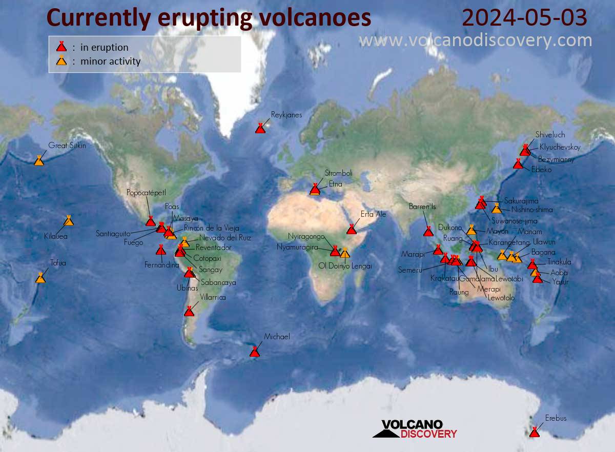
TODAY This is a very high number of eruptions in one day 7 of today's volcanoes erupted in South America, where there were also many quakes with magnitudes of 4 - 5, - also a deep earthquake from 170 km under Colombia with M5.2 was there. 5 volcanoes are in eruption on Indonesia and also the behavior of the Lewotobi Laki-Laki testifies to this, which was not the only one this year who surprised the "experts" - just think of the Ruang volcano, which made a VEI 5 eruption in May! That's the same intensity as Mt. St. Helen! And not to forget, - in Hawaii there was a strong earthquake with M4.9 today, - there is a new eruption pending, Etna and Stromboli in Italy had new crises these days, in Iceland the largest of the eruptions so far is looming and at the unmonitored rift valley in Africa something big is also announced!
https://www.volcanodiscovery.com/
Nov 6, 2024
James of Idaho
Every passage of Nibiru creates a crustal displacement either large or small and moves the crust over the Yellowstone hot spot as seen here in these images of southern Idaho....👽👽👽
Mar 30
Juan F Martinez
VOLCANO WATCH
Orb-UFO inspecting Monte Orizaba dormant volcano in Veracruz, México 8-2-25
We know that the Zetas and other ETs are closely monitoring volcanoes for signs of awakening, are they just observing and taking note or are these orbs also able to mitigate - soften the impact?
Pico de Orizaba, also known as Citlaltepetl, is the highest volcano in North America. It rises 5,636 meters (18,491 feet) above sea level and is located on the border between the Mexican states of Veracruz and Puebla. The volcano is currently dormant but not extinct, with the last eruption taking place during the 19th century. Another volcano in the region is Cofre de Perote, an inactive volcano located in Veracruz, where the Trans-Mexican Volcanic Belt meets the Sierra Madre Oriental.
Volcano watch - Earth Changes and the Pole Shift
https://poleshift.ning.com/profiles/blogs/volcano-watch
Pico de Orizaba - Wikipedia
https://en.wikipedia.org/wiki/Pico_de_Orizaba
Video in comments: https://x.com/ZT_Followers/status/1952448979306000681
Aug 4
Juan F Martinez
Activity on the Shiveluch volcano, Kamchatka. 12.09.2025.
https://poleshift.ning.com/profiles/blogs/volcano-watch
https://t.me/ZetaTalk_Followers/76743
Sep 13
Juan F Martinez
Hot Earth, Faultline Fire, tectonic heat caused by the Africa Roll #6 and Mediterranean Floor Drop #7.
Köyceğiz, Muğla, Türkiye 19.09.25
https://poleshift.ning.com/profiles/blogs/volcano-watch
Video in comments: https://t.me/ZetaTalk_Followers/76973
Sep 19
Tracie Crespo
Episode 33! September 19, 2025. #Kilauea #Volcano
https://www.facebook.com/share/r/1Gvuoue3VP/
https://www.facebook.com/share/r/1ZvRmfzKn2/
Sep 20
Juan F Martinez
How will people respond to the world burning around them?
Hot Earth Wildfires ravage the Mediterranean coast of Turkey. Tourists refuse to abandon their prepaid luxury hotels until the very last minute.
THE UNTHINKABLE MESSAGE, HOW WILL PEOPLE RESPOND?
ZetaTalk: Until the Last Days, written Mar 24, 2006
We have stated that when the pole shift hits, the majority of the world's population will not have been warned, and that even among those warned denial will be high. We have stated that among those hearing the warning and taking it seriously, the reaction may be to party to the end, rather than take steps for safety or prepare for a life after the shift.
https://www.zetatalk.com/index/blog0816.htm
Sep 20
Juan F Martinez
Two volcanoes in Indonesia have just erupted: Merapi and Lewotobi.
https://t.me/ZetaTalk_Followers/77727
Oct 9
Juan F Martinez
Volcano Popocatepetl, Mexico, 10.10.25.
We are witnessing what seems like Divine Intervention. The Zetas and other benevolent extraterrestrials are monitoring volcanoes to provide advance warning to their partners on the ground.
The activity at the Popocatepetl volcano near Mexico City is an early warning sign that the New Madrid fault bow may soon release. These probes appear to be taking measurements. Recently, there has been a notable increase in such sightings.
These events suggest that the New Madrid Finale is close, coinciding with the anticipated visibility of Nibiru in November. No coincidence that military and National Guard units are being deployed, martial law to control the anticipated panic is next.
VIDEO: https://t.me/ZetaTalk_Followers/77770
https://poleshift.ning.com/profiles/blogs/volcano-watch
Oct 10
Juan F Martinez
https://poleshift.ning.com/profiles/blogs/volcano-watch
VIDEOS: https://t.me/ZetaTalk_Followers/77825
Oct 12
Tracie Crespo
https://www.bigislandvideonews.com/2025/10/17/dual-lava-fountains-r...
Image from USGS webcam on Friday night
by Big Island Video News
on Oct 17, 2025 at 9:51 pm
HAWAIʻI VOLCANOES NATIONAL PARK - Episode 35 sustained lava fountaining began just after 8 p.m. on Friday night.
(BIVN) – Dual lava fountains returned to the summit of Kilauea on Friday night, as Episode 35 in the ongoing eruption began just after 8 p.m.
The USGS Volcano Alert Level for Kīlauea remains at WATCH and the Aviation Color Code is at ORANGE.
By 9:30 p.m., fountains erupting from the south vent topped 1,300 feet (400 meters), while the fountain from the north vent reached about 1,100 feet (330 meters).
Scientists with the USGS Hawaiian Volcano Observatory said it was a record fountain height for two fountains during the eruption, which began in December 2024.
Image from USGS webcam on Friday night
“According to the National Weather Service, overnight winds are blowing from the north, which suggests that volcanic gas emissions and volcanic material may be distributed south of Kilauea summit,” the USGS HVO said.
“Seismic tremor increased significantly, and summit tilt switched from inflation to deflation at about the same time that sustained fountaining began,” the scientists wrote. “Inflationary tilt reached approximately 24 microradians since the end of the last episode.”
No changes have been detected in the East Rift Zone or Southwest Rift Zone. All current activity is confined to the summit caldera within Hawaiʻi Volcanoes National Park.
Oct 18
Juan F Martinez
The ash and steam plume from the volcano is estimated to reach about 2000 m (6561 feet) above the crater.
https://poleshift.ning.com
Oct 25
Juan F Martinez
VIDEO: https://t.me/ZetaTalk_Followers/78398
Oct 25
Tracie Crespo
A powerful eruption occurred at Taal Volcano in Batangas, Philippines 🇵🇭 (26.10.2025)
The Tokyo Volcanic Ash Advisory Center (VAAC) reported an ash plume rising over 2,400 meters above the volcano’s crater.
Via https://t.me/Disaster_News
Oct 26
Juan F Martinez
VIDEO: https://t.me/ZetaTalk_Followers/78610
Oct 31
Juan F Martinez
VIDEO: https://t.me/ZetaTalk_Followers/78948
Nov 10
Tracie Crespo
https://www.foxweather.com/earth-space/volnadoes-rare-hawaii-volcan...
See it: Large 'volnadoes' swirl during volcanic eruption in Hawaii
Kilauea erupted again on Sunday, marking the 36th episode, lasting just over five hours. Video footage captured by Australian tourist David Finlay shows an unexpected twist amid the powerful eruption, where smoke from the lava fountains combined with strong winds.
Video footage captured by Australian tourist David Finlay shows four "volnadoes" swirling amid a volcanic eruption in Hawaii.
KILAUEA, Hawaii – A breathtaking scene unfolded in Hawaii as Kilauea erupted with a unique sight caught on camera.
Kilauea erupted again on Sunday, marking the 36th episode, lasting just over five hours. Video footage captured by Australian tourist David Finlay shows an unexpected twist amid the powerful eruption, where smoke from the lava fountains combined with strong winds.
The outcome is a spectacular vortex of dark smoke caused by the large lava fountains to create a "volnado" phenomenon.
TIME-LAPSE VIDEO SHOWS THE POWER OF KILAUEA'S ERUPTION
"We have four ‘volnadoes’…That one’s really cool, look at that!" Finlay says in the footage.
A swirling tornado of smoke amid a volcanic eruption in Hawaii.
(David Finlay via Storyful)
According to the U.S. Geological Survey (USGS), lava fountains reached a maximum height of 1,000 to 1,100 feet during the extensive eruption. Lava flows from the eruption produced just under 11 million cubic yards around the area.
KILAUEA ERUPTION CAUGHT ON CAMERA DOZENS OF TIMES
"How cool is this state?" Said Finlay as he watched the four fiery twisters. "This is the best place."
FILE: This animated image shows lava shooting from inside Hawaii’s Kilauea volcano during its most recent eruptive episode in August, 2025.
(USGS / FOX Weather)
Luckily for onlookers, this episode occurred within a closed area of the Hawaii Volcanoes National Park. A significant hazard associated with an eruption is the fallout of Pele’s hair and other volcanic fragments falling from the sky.
WATCH: EXPLOSIONS, LAVA BURSTS FROM VOLCANO LIGHT UP THE NIGHT SKIES IN GUATEMALA
According to the USGS, Pele’s hair is strands of volcanic glass usually produced by lava fountain activity, which can be carried over 10 miles.
Nov 12
Tracie Crespo
https://www.reuters.com/business/environment/japans-sakurajima-volc...
Japan's Sakurajima volcano erupts, ashfall cancels flights
Nov 17