Earth Changes and the Pole Shift
New Madrid
There has been much made of an earthquake in the recent past long the New Madrid fault line, as this was unexpected, being in a quiescent area, and thus raised all manner of questions regarding the possibility of massive earthquakes in areas presumed to be safe. Simply put, there are no earthquake free areas, and during the coming pole shift, all parts of the globe will be subject to them, without exception. Thus, individuals living in areas which have never experienced an earthquake should not presume safety but should take the same steps in preparing for the pole shift that those living atop highly active fault lines take - stay out of old or masonry buildings, and anticipate earthquakes as severe as any that mankind has ever experienced and noted.
ZetaTalk ™
Our description on the pole shift itself describes not a single jolt when the crust stops moving but a series of jolts. Most severe earthquakes are like this, in fact, if one examines their pattern. There are small quakes ahead of time, swarms, and jiggling that unsettles people as they sense something is pending. Then when the rock fingers that are preventing the fault line from sliding or subducting suddenly break, a large jolt. This often, within minutes, results in more jolts as the pressure that was at one point now moves to be pressure at the next point where rock fingers are holding the slippage. Aftershocks result, as yet more rock fingers break, until a point arrives where there is so much resistance to slippage that the quake and its after effects is considered complete.
For the New Madrid, which will include the European tsunami in its effects, there will be one large jolt with a subsequent and almost immediate tearing of the Atlantic. We have stated that the European tsunami will be the largest, but smaller ones will follow in time. Likewise for the New Madrid adjustment, which involve a tearing of the entire N American continent from the seaway down to Mexico. This adjustment will not occur until minor rock fingers have been steadily broken in a number of places. The areas to be affected have already been experiencing quake swarms, buckling roadways, sinkholes, breaking dams, and unsettling jigging which is unexplained by the authorities. When the primary blockage gives, there will be a huge jolt, with little warning. Aftershocks will continue until the time of the pole shift itself.
ZetaTalk ™ 2010
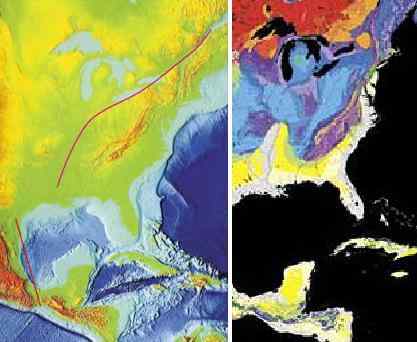
It is known by man that the New Madrid Fault line runs beyond the immediate area of New Madrid. When we stated that "Chicago will rupture and adjust" and "Ohio will be pulled in places" this should not be news to man. The New Madrid runs up along the Seaway, to the mouth of the Seaway, and thus will rupture any land it passes through. Plot its course and consider that more than the fault line itself will be disrupted. Rock detached from its former connections is free to react to the dominant theme in the area. If rock was held down, formerly, it can bounce up. If rock was held back, it is free to spring forward. And adjustment in rock strata means that loose soil will sink or heave. This most certainly can affect a broader area than just the fault line. We have stated that Ohio will be affected most in this regard. These matters are related to the rock strata, which bonds or breaks, as we have stated. There is a natural break in the rock strata holding Ohio, along the Ohio River and into its headwaters, as can be seen. Why should Chicago be affected? There is a natural break in the rock strata between the New Madrid and Chicago also, a weakness, which will rupture with the New Madrid. When the Seaway pulls apart there will be a dropin support formerly present during rock attachments. Chicago has long been predicted, by ourselves and others, to be devastated. Much of the infrastructure will rupture, causing buildings to crumble and freeways to be worthless and irreparable. One need only follow the geology of the region, to predict what will happen.
ZetaTalk ™ 2010
During the 7 of 10 New Madrid adjustment the Seaway will be affected, as we mentioned earlier. It will not tear open to the degree we predicted for the pole shift itself, but weak points along the Seaway will adjust. During the 7 of 10 Duluth will find crevasses nearby, similar to the crevasse that has occurred recently in the Michigan Penninsula, but with greater depth and scope. Inland locks along the Seaway will break. Detroit and Toronto will be unaffected during the 7 of 10 except of course for earthquake damage. As the New Madrid fault line runs up along the Seaway just under the Great lakes in Ohio, cities such as Cleveland and Toledo will find their infrastructure greatly shattered in places as the rock beneath them will jut and drop, vertical adjustments. Buffalo, being virtually on the fault line, will likewise be shattered in this way, such that freeways become useless, but the seaway at Niagara Falls will remain.
ZetaTalk ™ 2010
As both sides of the New Madrid Fault Line are pulled in opposite directions, the entire fault line operates as a slip-slide fault line. In that the land just to the west of the Mississippi River moves the greatest distance, to ease the pressure on the bow currently formed by the N American continent, this creates a void, a stretch zone void, causing the land there to drop, as we have explained. This is the region currently experiencing precursor earthquakes, the region considered the New Madrid region. But the movement is not yet happening, the void not yet being created. Instead, occasional slight slip-slide adjustments are being made, deep within the rock strata, causing minor quake swarms or sympathetic jolts in neighboring areas. The rock fingers are slipping, but not losing their grip.
When the plate tearing starts in earnest, these slip-slide jolts will be huge, and rise up to the magnitude 8-9 range, as we have stated. These quakes will ride up to the bend in the fault line just south of Lake Michigan. Earthquake damage is primarily done when the rock close to the surface is affected, as is known by man. The quality of the rock along the fault line thus affects the shaking and resulting damage to the surface. A glance at a map of the geology of the fault line shows that the rock along the Mississippi at Arkansas and Missouri is younger, laid down by sediment, and tends to fracture broadly, thus relaying earthquake jolts over a vast area. Broad fractures also cause post quake adjustments, so the quake includes rock shuffling, all of which translates to a larger magnitude for the area. Thus, the worst of the New Madrid adjustment will be felt in this area.
The rock strata that hold Illinois and Indiana is older, and more solid. Fracturing of the rock tends to be a single jolt, not the multiple ricocheting jolts that magnify any adjustment in the rock strata experienced by the rock strata in Arkansas and Missouri. The magnitude will still be considered high, perhaps an 8, but the shaking will not last as long, and the damage therefore not as great. Were the bend in the fault line just south of Lake Michigan not at a point where the southeastern part of the US is dropping away from the Seaway, the damage along the Seaway would be much greater. The Equator is expanding in the center of the Atlantic, and has already, by this time, ripped open between S America and Africa. The southeast thus drops toward this void, relieving pressure and friction along the slip-slide in the fault line as it runs under the Seaway.
By the time the New Madrid adjustment reaches the bend, land to the west of the Mississippi has already dropped, pulled away, but this actually puts more pressure on the fault line as it runs under Michigan. This holds, momentarily, while the southeast starts to drop toward the Atlantic Rift, and then pulls apart sharply. Here, beneath Michigan, the jolts will also not last for long, and will also be considered up to magnitude 8. The fault line thence along the Seaway will unzip, along rock strata borders already established. Where stretch zones such as this normally have adjustments that are basically silent, they do much damage. The unzipping creates crevasses and landslides and sinkholes, and when this occurs under cities is devastating. The quakes will be considered much less than magnitude 8 but the damage will be greater, with consequent lost of life and infrastructure. A building that has collapsed because of a large jolt is no different than one that has collapsed because the ground beneath it sank.
As is known, there is a fault line running up along the East Coast of the US that attaches to the New Madrid fault line in the Gulf. Both fault lines touch there, in the Gulf, and when the New Madrid adjusts there is a sympathetic adjustment up along this fault line. During the last New Madrid adjustment, church bells rang in Boston and cracks appeared in buildings in Savannah, GA and Charleston, SC. These changes are caused by earthquakes equivalent to a magnitude 4-5 or less, not serious.
ZetaTalk ™ March 19, 2011

Note New Madrid Sequence commentary.
Note USGS Signals commentary.
Source: New Madrid
Juan F Martinez
New Madrid ~M5.3
Magnitude mb 3.3 + 2
Region SOUTHEASTERN MISSOURI
Date time 2019-10-12 13:55:25.5 UTC
Location 36.57 N ; 89.65 W
Depth 10 km
Distances 611 km S of Chicago, United States / pop: 2,696,000 / local time: 08:55:25.5 2019-10-12
261 km W of Nashville, United States / pop: 531,000 / local time: 08:55:25.5 2019-10-12
11 km W of New Madrid, United States / pop: 3,200 / local time: 08:55:25.5 2019-10-12
4 km SW of Lilbourn, United States / pop: 1,200 / local time: 08:55:25.5 2019-10-12
Oct 13, 2019
Nancy Lieder
Per the Zetas, the New Madrid adjustment has started. Newest ZetaTalk as of October 12.
Hard Rock Hotel Collapse in New Orleans Kills One and Injures at Least 18
https://www.youtube.com/watch?v=1Yfdk8mO-pc
October 12, 2019
Parts of a Hard Rock Hotel under construction in New Orleans collapsed. The New Orleans Fire Department received reports of a collapsed building around 9:12 a.m., The top six to eight floors of the building were affected.
SOZT
We have described the New Madrid adjustment as starting in the soft rock
http://www.zetatalk.com/info/tinfx127.htm
under the Mississippi River from the Illinois border to the Gulf of Mexico. This region will pull apart by up to 50 miles, tearing the bridges that cross the Mississippi. The land to the west of the Mississippi will sink
http://www.zetatalk.com/info/tinfx085.htm
and slide to the southwest. The New Madrid Fault Line will first rip open where it touches the Gulf of Mexico. This is where the New Madrid Fault Line connects with the East Coast Fault Line running up the East Coast and others branching to the west and into the Gulf.
The sinkhole at Bayou Corne,
http://www.zetatalk.com/newsletr/issue309.htm
lying just to the west of New Orleans, shows this weakness. The soft rock strata is also widest at this point, narrowing as it rises toward Memphis. As the New Madrid Fault Line separates and pulls apart in a diagonal manner, it will give way at its weakest point, which is under the Gulf of Mexico at the mouth of the Mississippi. Rivers flow along the lowest points in the crust, which is where the crust is thin and thus has drooped.
What is the significance of the Hard Rock Hotel collapse in New Orleans, just a few blocks from the Mississippi? Though under construction, several stories had been built and no signs of weakness had been noted. Cracks in other buildings in New Orleans to the west of the Mississippi are likely to be discovered, as the ground is dropping and pulling away from the center of the Mississippi River, as we predicted. This is the start of the New Madrid adjustment.
EOZT
Oct 13, 2019
Nancy Lieder
And a water main break nearby shows the elevation changed.
Water Gushes out of Uptown Broken Water Main; Boil Water Advisory Issued
October 12, 2019
https://www.fox8live.com/2019/10/12/water-gushes-out-uptown-broken-...
A 48-inch diameter water main broke near the corner of Lowerline and Panola streets, causing water pressure to fall below 20 psi in the areas bounded by Carrollton Avenue, Interstate 10, the Pontchartrain Expressway, Calliope Street and the Mississippi River. Residents in the affected area are advised to use bottled or boiled tap water to drink, cook, clean food or brush teeth until further notice.
Oct 13, 2019
Juan F Martinez
Earthquakes Continue in New Madrid Fault as Central States Prepare For the Great Central U.S. ShakeOut Earthquake Drill
Yesterday, a M3.0 quake and today several tremors hit inside the New Madrid Fault Line. The New Madrid Seismic Zone is constantly shaking since about 1 month, now.
Meanwhile Missouri prepares for the Great Central U.S. ShakeOut Earthquake Drill that will take place on October 17, 2019.
The New Madrid Seismic Zone is continuously shaking since about one month now, when a M3.7 earthquake rumbled parts of southern Missouri and northern Arkansas on September 12, 2019. This strong quake for the region was followed by a series of small quakes near Lilbourn, Missouri.
In addition, a small M3.0 earthquake rattled southeastern Missouri, yesterday, Oct. 12. And today 2 more small earthquakes hit near Lilbourn and Ridgely, right in the red zone of the New Madrid Fault.
The magnitude 3.0 earthquake occurred just before 8 a.m. Saturday and was centered about 2.7 miles (4 kilometers) southwest of Lilbourn. Although, no reports of damage or injuries were received, more than 40 reported feeling the quake on the USGS homepage.
The Great Central U.S. ShakeOut Earthquake Drill
Following FEMA’s “National Preparedness Month” in September, millions of people will participate in the Great Central U.S. ShakeOut earthquake drill on Thursday, October 17, 2019 and practice how to Drop, Cover, and Hold.
Below, an animated video from FEMA about how to prepare for an earthquake and what to do during an earthquake:
https://strangesounds.org/2019/10/earthquake-new-madrid-seismic-zon...
Oct 13, 2019
Nancy Lieder
On October 27, yet another quake swarm at New Madridd. There are no recent quakes above this point on the Mississippi or Ohio Rivers, nor below this point either. This area (New Madrid) is where the soft rock ends and hard rock begins. Soft rock can only stretch so much, and then the rip will move into the hard rock. Then it becomes BOOM.
Oct 27, 2019
Juan F Martinez
7 million people at risk of massive New Madrid quake
Experts fear worst when big one finally hits
October 16, 2019 -
ST. LOUIS (KMOX) — Drop, cover, and hold on. That's probably all you be able to do when the big one hits.
And have no doubt, experts tell KMOX we're due for a major earthquake.
Jeff Briggs, Earthquake Program Manager for the Missouri State Emergency Management, says we live in one of the largest active earthquake zones in the US, east of the Rocky Mountains. More than 200 measurable quakes a year happen in the New Madrid Seismic Zone centered in Southeast Missouri. "There are roughly 7 million people who live in the high impact area who would be affected by a New Madrid Seismic Zone."
Experts believe the 7-plus magnitude quakes the region experienced in the early 1800s are an indication we'll be hit again. They were felt across the Eastern US.
Briggs warns you will have absolutely no advanced warning, no time to prepare when the shaking starts.
"Falling debris is what's going to hurt the vast majority of people," he explains. "Day one after a big New Madrid Seismic Zone earthquake, we estimate about 2.5 million people will be without power, and more than a million people will be without water, and they could be without those services for up to two weeks."
Briggs adds an estimated 3,500 people could be killed with more than 80,000 injured.
What can you do right now? Get disaster supplies ready, of course.
Another safety measure Briggs recommends is to get heavy objects off high shelves and secure large furniture to the wall.
Briggs says you should practice what you'll do the instant the earth starts to shake — drop to the ground, cover yourself either with furniture, or cover your head with your arms, and hold on until the shaking stops. In fact, half a million people in Missouri will practice those techniques as part of the Great ShakeOut.
https://kmox.radio.com/articles/news/new-madrid-fault-line-puts-7-m...
Oct 28, 2019
Juan F Martinez
Science of the New Madrid Seismic Zone (USGS)
Overview
When people think of earthquakes in the United States, they tend to think of the west coast. But earthquakes also happen in the eastern and central U.S. Until 2014, when the dramatic increase in earthquake rates gave Oklahoma the number one ranking in the conterminous U.S., the most seismically active area east of the Rocky Mountains was in the Mississippi Valley area known as the New Madrid seismic zone. Since 1974, seismometers, instruments that measure ground shaking, have recorded thousands of small to moderate earthquakes. The faults that produce earthquakes are not easy to see at the surface in the New Madrid region because they are eroded by river processes and deeply buried by river sediment. A map of earthquakes epicenters, however, reflects faulting at depth and shows that the earthquakes define several branches of the New Madrid seismic zone in northeastern Arkansas, southwestern Kentucky, southeastern Missouri, and northwestern Tennessee. Other relatively young faults, which are not necessarily associated with recent earthquakes, or the main seismicity trend in the New Madrid region, are shown in this map. It shows 20 localities where geologists have found and published their findings on faults or evidence of large earthquakes.
1811-1812 Earthquakes
The first principal earthquake, M7.5, occurred at about 2:15 am (local time) in northeast Arkansas on December 16, 1811. The second principal shock, M7.3, occurred in Missouri on January 23, 1812, and the third, M7.5, on February 7, 1812, along the Reelfoot fault in Missouri and Tennessee.
https://earthquake.usgs.gov/earthquakes/events/1811-1812newmadrid/s...
In the winter of 1811 and 1812, the New Madrid seismic zone generated a sequence of earthquakes that lasted for several months and included three very large earthquakes estimated to be between magnitude 7 and 8. The three largest 1811-1812 earthquakes destroyed several settlements along the Mississippi River, caused minor structural damage as far away as Cincinnati, Ohio, and St. Louis, Missouri, and were felt as far away as Hartford, Connecticut, Charleston, South Carolina, and New Orleans, Louisiana. In the New Madrid region, the earthquakes dramatically affected the landscape. They caused bank failures along the Mississippi River, landslides along Chickasaw Bluffs in Kentucky and Tennessee, and uplift and subsidence of large tracts of land in the Mississippi River floodplain. One such uplift related to faulting near New Madrid, Missouri, temporarily forced the Mississippi River to flow backwards. In addition, the earthquakes liquefied subsurface sediment over a large area and at great distances resulting in ground fissuring and violent venting of water and sediment. One account of this phenomena stated that the Pemiscot Bayou "blew up for a distance of nearly fifty miles."
After the earthquake [of 1811-1812] moderated in violence, the country exhibited a melancholy aspect of chasms, of sand covering the earth, of trees thrown down, or lying at an angle of forty-five degrees, or split in the middle. The Little Prarie settlement was broken up. The Great Prarie settlement, one of the most flourishing before on the west bank of the Mississippi, was much diminished. New Madrid dwindled to insignificance and decay; the people trembling in their miserable hovels at the distant and melancholy rumbling of the approaching shocks.
Liquefaction
The most obvious effects of the 1811-1812 earthquakes are the large sandy deposits, known as sand blows, resulting from eruption of water and sand to the ground surface. This phenomenon called earthquake-induced liquefaction is the process by which water-saturated, sandy sediment temporarily loses its strength due to the buildup of water pressure in the pores between sand grains as seismic waves pass through the sediment. If the pore-water pressure increases to the point that it equals the weight of the overlying soil, the sediment liquefies and behaves as a fluid. The resulting slurry of water and sediment tends to flow towards the ground surface along cracks and other weaknesses. Overlying soil "floating" on liquefied sediments moves down even gentle slopes, causing fissuring and lateral and vertical displacements. This type of landslide known as lateral spreading is commonly responsible for damage to infrastructure (bridges, roads, buildings) during major earthquakes.
Photograph and schematic cross-section illustrating earthquake-induced liquefaction and formation of sand dikes and sand blows (modified from Sims and Garvin, 1995).
During the 1811 and 1812 earthquakes, liquefaction and resulting lateral spreading was severe and widespread. Sand blows formed over an extremely large area about 10,400 square kilometers. Effects of liquefaction extended about 200 km northeast of the New Madrid seismic zone in White County, Illinois, 240 km to the north-northwest near St. Louis, Missouri, and 250 km to the south near the mouth of the Arkansas River. In the New Madrid region, sand blows can still be seen on the surface today. In the past, the sand blows were attributed to the 1811-1812 earthquakes. We now know that some of the sand blows pre-date 1811 and formed as the result of prehistoric New Madrid earthquakes.
In the New Madrid seismic zone, many sand blows appear as light-colored sandy patches in plowed fields. Flood deposits bury other sand blows. Viewed from above, sand blow have circular, elliptical, and linear shapes and can range up to tens of meters in width and hundreds of meters in length. Viewed in cross-section or in excavations and riverbanks, sand blows commonly take the form of large lenses 1 to 2 m in thickness. Sand blows composed of several layers that fine upward from coarse sand to silt and capped by clay probably formed as a result of multiple earthquakes. Sand blows usually contain clasts, pieces of underlying deposits and soil horizons ripped from the dike walls as the liquefied sand erupted to the surface.
https://earthquake.usgs.gov/learn/topics/nmsz/1811-1812.php
Oct 29, 2019
Nancy Lieder
New ZT re the heaving Missouri River:
Continuous flooding of the Missouri river. Although there are several causes listed in the article, I can’t help but wonder if the sinking of the central US has started. It is also interesting that this topic is not getting any press.
[and from another]
https://www.kshb.com/news/state/missouri/prolonged-missouri-river-f...
Prolonged Missouri River flooding could last all winter: 'No end in sight'
October 28, 2019
Flooding along the Missouri River has stretched on for seven months. There are several reasons for the flooding, including high levels along the river, saturated ground and broken levees. Similar conditions exist in places along the lower Missouri River.
SOZT
Certainly the Mid-West was flooded in late March, early April of 2019,
http://www.zetatalk.com/newsletr/issue654.htm
but after 7 months these regions should have drained. Do these regions remain flooded every Spring after the Winter snows have melted? They drain. Thus there is another reason the waters are backed up. It is of record that when the New Madrid Fault Line ruptured in 1811-1812 that the Mississippi River briefly ran backward. The ground heaves, and heaved just two years ago in October 2017
http://www.zetatalk.com/newsletr/issue575.htm
just above the New Madrid region.
The Missouri River joins the Mississippi River at St. Louis, but there are no reports of the Mississippi River backing up. It is the Missouri River this time. Such heaving indicates pressure on hard rock layers. The New Madrid Fault Line ruptures at New Madrid because this is where the soft rock that rises up from the Gulf comes to a point, and meets hard rock. The current quake swarms at New Madrid, though small, show the same pattern as occurred in 1811-1812, bouncing from one side of the Mississippi to the other. As we said on October 12 when the Hard Rock Hotel collapsed, the New Madrid adjustment has begun.
EOZT
Prior ZT: http://www.zetatalk.com/ning/31oc2017.htm
Heaving land was noted during the last major New Madrid adjustment, when the river was reported to run backward. Rock strata being asked to rip on a diagonal will resist, and during this resistance will bunch up to create a heave. When the pressure to rip at a diagonal is eased, due to land elsewhere moving instead, then the heave relaxes and seemingly goes back to normal.
Oct 29, 2019
Juan F Martinez
Magnitude M 2.7 Region SOUTHERN QUEBEC, CANADA
Date time 2019-10-30 19:19:33.0 UTC
Location 47.10 N ; 76.43 W
Depth 18 km
Distances 196 km N of Ottawa, Canada / pop: 813,000 / local time: 15:19:33.0 2019-10-30
87 km NW of Ferme-Neuve, Canada / pop: 2,200 / local time: 15:19:33.0 2019-10-30
Oct 31, 2019
Nancy Lieder
More new ZetaTalk on why the quakes shift from west to east side of Mississippi, and what this means for the future!
We have stated that the New Madrid rupture starts at the Gulf, where the Mississippi River outlet is lowest and thus the crust is thinnest and sagging. The soft rock stretches to accommodate the diagonal pull on the N American Continent. As we have stated, the western side of the Mississippi River will drop, flooding to a width of 50 miles, during the New Madrid adjustment, and this can be seen by the location of recent quakes along the Mississippi. This also happened during the Hard Rock Hotel collapse. Soft rock stretching to the WEST thus occurs first.
The hard rock above and to either side of New Madrid does not stretch, but the rock layers overlap to relieve the pressure. Thus the heaving in Missouri, causing a backwash up the Missouri River. This can cause a permanent elevation increase in Missouri, as the Ozark Mountains attest. When these adjustments do not suffice, the stress switches to the east side of the Mississippi, which is why the quake swarms have now switched to the Tennessee side. The east side is being pulled upward and toward the northeast, and heaving may occur in Tennessee for this reason.
Now the tug both to the southwest and to the northeast are in place, and intensifying. When the hard rock above New Madrid can no longer adjust by rock layers overlapping, the New Madrid Fault Line will begin to tear the hard rock. The soft rock below New Madrid will likewise rip, rather than stretch. Each segment of the fault line will be put under intense stress, and quickly fail in a domino fashion. The New Madrid Fault Line will rapidly unzip toward Chicago and then East under the Seaway.
Oct 31, 2019
Nancy Lieder
Police investigate loud “boom” heard in Wichita area November 2, 2019
https://www.kfdi.com/2019/11/02/police-investigate-loud-boom-heard-...
People in Wichita and surrounding communities reported hearing a loud boom sound Saturday afternoon, but there is no word on the origin of the sound.
[and from another]
Loud boom reported in Wichita, surrounding communities; origin unknown November 2, 2019
https://www.kansas.com/news/local/article236945218.html
People in Wichita and surrounding communities posted on social media about hearing a loud noise and feeling their houses shake Saturday. A Sedgwick County dispatcher said they received about six calls about a supposed explosion around 1:30 p.m.
[and from another]
Source of loud boom over Wichita remains mystery November 2, 2019
https://www.kwch.com/content/news/Wichita-police-investigating-repo...
The source of a loud boom and rattling reported in Wichita Saturday remains a mystery. Officials at McConnell Air Force Base say it did not come from the base and the United States Geological Survey did not report any earthquakes at that time. There also were no explosions.
[and from another]
What in the world was that? Loud boom, shaking, rattles many in the Wichita metro area November 2, 2019
http://www.kake.com/story/41263444/what-in-the-world-was-that-loud-...
The American Meteor Society has weighed in on the "boom" that many of us around Kansas and Oklahoma heard earlier this afternoon. It appears as if the best answer to the boom we heard is a meteor, but this hasn't been confirmed.
[and from another]
https://earthquake.usgs.gov/static/earthquake-network-operations/Se...
Data from Station US OXF (Oxford, Mississippi, USA) last updated at Tue 11/05/19 12:32 MST (Tue 11/05/19 19:32 UTC)
SOZT
Many signs of the pending New Madrid adjustment are subtle, and unless linked together do not in and of themselves appear significant. Why would a loud boom and rattling houses from snapping rock in Wichita relate to the tension in the New Madrid region? We have stated that heaving around the Missouri River is due to the hard rock there crunching and bending instead of ripping. If the rock under the Ozarks is heaving, where does this process end?
Wichita is on the Arkansas River, which empties into the Mississippi near Oxford, Mississippi. Just as the Missouri River bounds the Ozarks on the north, the Arkansas River bounds the Ozarks on the south. Thus the pressure of the heaving Ozarks transferred to Wichita. There was a temporary rebound all the way down the Arkansas River bed to where the river empties into the Mississippi. Except for a diligent observer, the seismograph reaction in Oxford would not have been noticed.
EOZT
Nov 6, 2019
Nancy Lieder
Now the Black Hills are participating! Note the ZetaTalk on how the Seaway ripping open arrives at the Black Hills, and how this will be one of the clues that the New Madrid is getting ready for the big one!
11/7/2019
Seismograms show Black Hills black, but no other seismo sites participate, only a blip in Texas and at Yellowstone nearby. Oxford, MS which lies where the Arkansas River empties into the Mississippi River, is wobbly. This shows that the jolts, which are NOT earthquakes, are related to the New Madrid. The Black Hills is the endpoint where the Seaway ripping open lands.
https://earthquake.usgs.gov/monitoring/operations/heliplot.php?virt...
ZetaTalk 2007 http://www.zetatalk.com/index/zeta355.htm
The yawing Seaway rumples the land in the Black Hills, which is why this land looks like it was thrown in the air, recently, as it was during the last pole shift and in pole shifts prior.
ZetaTalk 2006 http://www.zetatalk.com/index/zeta261.htm
This creates a diagonal stress on the N American continent where New England is pulled to the east while Mexico is pulled to the West, so the New Madrid is put under slip-slide stress where one half, east of the Mississippi, will move toward the NE while the other, west of the Mississippi, moves toward the SW. A widening seaway also does not affect just those land masses bordering the seaway, as buckling occurs inland and afar. What does man assume caused the Black Hills to be so rumpled, with the appearance of a recent buckling and heaving? This is the center of a land plate! The tearing of the seaway does not end at Duluth, Minnesota, it travels underground to S Dakota!
ZetaTalk 2010 http://www.zetatalk.com/7of10/7of10-62.htm
Indeed, tearing of the St. Lawrence Seaway will occur during the New Madrid adjustment. We have warned that quakes on the West Coast, or the Seaway, or in the New Madrid region will occur before the major quake in the New Madrid region we have referred to as the adjustment on a 7 of 10 level. Mexico will lurch to the west as this major quake occurs, with a settling of land to the west of the Mississippi almost instantly afterwards. The Mississippi will seem to have widened, and those to the west will see a new view as they look east, as their land will have shifted to the southwest as well as dropped. Because the lurch of Mexico to the west actually intensifies the bowing of the N American continent, the Seaway tears open. This is actually various adjustments at weak points along the Seaway rather than the tearing apart into a larger inland bay that occurs during the pole shift itself. Niagara Falls will remain, but some of the inland locks will break. When the upper Mississippi region finds the land to its west slipping down and to the southwest, those parts north which were formerly firmly attached find they can spring northward, as the pressure from the bow had been inclining them to do. This allows the edge of the rip, at Duluth, MN, to tear further inland, with consequent rumpling in S Dakota and minor shifting of ground in all parts in between.
Nov 7, 2019
Nancy Lieder
On November 6 the methane released during the Wichita bang or the crunching, heaving rock of the Ozarks reached Kansas City. If Wichita was on the Arkansas River wrapping around the Ozarks, Kansas City is more central to the Ozarks. Note that other towns nearby did not get the poop smell, so the excuse that this was caused by winds blowing in from the north is unlikely. This is breaking rock, releasing methane.
Entire Kansas City Suffocating from Outhouse Odor after Wind brings Rural Life Experience
November 7, 2019
https://www.rt.com/usa/472887-kansas-city-smell-poop/
Kansas City has been caught off balance by a chemical attack of sorts, as strong smell of manure filled the streets and prompted the wildest speculations among Kansas and Missouri residents. Meanwhile, media blamed the weather. The city got engulfed in a mass of air that basically smelled like excrement.
Nov 8, 2019
Juan F Martinez
After Leak in North Dakota, Keystone Pipeline Restart Waiting on Corrective Action November 8, 2019
https://www.insurancejournal.com/news/midwest/2019/11/08/548023.htm
"This is the fourth significant spill from the Keystone pipeline in less than ten years of operation."
https://www.salon.com/2019/11/01/keystone-pipeline-leaks-383000-gal...
The Keystone pipeline, which carries tar sands oil into the United States, has leaked a large amount of oil across North Dakota. TC Energy, the pipeline’s owner (formerly known as TransCanada) has had to shut down the pipeline due to the leak.
The company released a statement, acknowledging the emergency:
“TC Energy immediately began the process to shut down the pipeline, activated its emergency response procedures and dispatched ground technicians to assess the situation.”
The immediate affected area is some 2,500 square yards, the company said. According to State Environmental Quality Chief Dave Glatt, the company notified regulators of the leak 29 October. Within 24 hours, the oil leak had spread by 1,500 feet long and 15 feet wide.
The company is said to be containing the spill and cleaning up the damage, but according to Brent Nelson, an emergency response manager, the clean-up might take somewhere between two and three months to complete.
Environmental Quality Chief Glatt stated that the area’s drinking water remains unaffected, however some surrounding wetlands remain damaged.
In 2013, a similar oil spill happened when Tesoro Corp spilled 840,000 gallons of fracked oil onto North Dakota farmland. It took almost 5 years and over $100 million to clean up the mess. In 2011, another leak occurred in south-eastern North Dakota, and was blamed on a faulty pumping station.
The current TC Energy spill leaked an estimated 383,000 gallons, making it the second spill in as many years. In 2017, the pipeline was estimated to have leaked over 407,000 gallons of oil onto north-eastern farmland in a rural South Dakota area just shy of the North Dakota border.
https://www.captain-planet.net/keystone-oil-pipeline-in-north-dakot...
Nov 11, 2019
Juan F Martinez
https://www.emsc-csem.org/Earthquake/significant_earthquakes.php
Nov 13, 2019
Nancy Lieder
Notice the syncopation. The Seaway spreading stress at the Black Hills, where the rip of the Seaway ends. Then Oxford, MS likewise goes wobbly, as it is at the point where the Arkansas River touches the Mississippi, and the Arkansas River runs just under the Ozarks, which are heaving at present due to the hard rock there resisting the New Madrid adjustment. Then a 2.4 at New Madrid, which is actually a 4.2 if one adds the 2+ magnitude the Zetas state is being removed from all quakes these days by the USGS.
Nov 16, 2019
Nancy Lieder
Per the Zetas, all is in place for the big New Madrid adjustment - the Seaway spreading, the New Madrid region restless, heaving ground in the Ozarks, and West Coast quakes too, restless. What will set it off, per the Zetas, are large quakes at the tip of Mexico, which will be quickly followed by the unzipping of the New Madrid. Are these quakes in Mexico "large" enough? One can see the 7 of 10 hand here, as first the S American roll happens, then Mexico tip at the N American continent gets squeezed in a bow, which affects Kamchatka region as the N American Plate has a solid lip there which the Zetas say will not bend or break.
Nov 21, 2019
Nancy Lieder
We have been watching the Oxford seismo jitter when the Black Hills seismo goes black. Now we find that those "little" quakes nearby Oxford are in fact very DEEP. This rock is tearing, under the hard rock. The unzipping is in process!!
Digital First: Rare Mississippi Earthquake Wednesday Night
November 22, 2019
https://www.wjtv.com/top-stories/digital-first-rare-mississippi-ear...
We are on the southern edge of the New Madrid Seismic Zone. There have been three earthquakes this year in Mississippi: January 8th, Hollandale, Magnitude 3.7; August 9th, Canton, Magnitude 2.8; November 20th, Booneville, Magnitude 2.3
Nov 22, 2019
Juan F Martinez
New Madrid Region
Magnitude mb 3.7 Region OKLAHOMA
Date time 2019-11-22 21:54:05.6 UTC
Location 36.29 N ; 98.19 W
Depth 5 km
Distances 409 km N of Dallas, United States / pop: 1,198,000 / local time: 15:54:05.6 2019-11-22
110 km NW of Oklahoma City, United States / pop: 580,000 / local time: 15:54:05.6 2019-11-22
26 km E of Fairview, United States / pop: 2,600 / local time: 15:54:05.6 2019-11-22
South America Roll
M 5.2 MENDOZA, ARGENTINA
2019-11-22 22:27:31
Depth: 100 Km More details
https://www.emsc-csem.org/Earthquake/significant_earthquakes.php
Nov 23, 2019
Juan F Martinez
USGS reports 1.8 magnitude earthquake in Salem 10:47 PM EST Nov 23, 2019
The United States Geological Survey reports the quake was a magnitude 1.8 that hit at 9:45 p.m.
It was centered on Millville Street near Irving Street at a depth of 1.6 miles.
On Facebook, people all over the town reported hearing what sounded like a boom and some reported that their houses shook. Salem police took to Facebook to announce the small earthquake and thanked everyone for their concern.
There are no reports of any damage or injuries at this point.
https://www.wmur.com/article/usgs-reports-18-magnitude-earthquake-i...
Nov 24, 2019
Juan F Martinez
Cincinnati building collapse with three injured
by: The Associated Press
Posted: Nov 25, 2019 / 05:42 PM EST / Updated: Nov 25, 2019 / 05:42 PM EST
CINCINNATI (AP) – Authorities say at least three people have been injured in Cincinnati after part of a building under construction collapsed.
Cincinnati Fire Chief Roy Winston said three people on the structure’s fifth floor were injured when part of the building collapsed Monday afternoon after workers on the sixth floor started pouring concrete.
Winston said one worker had minor injuries and the other two had more serious injuries. He said all were in stable condition.
The chief said crews were searching for any others who might have been injured and contractors were making sure workers were accounted for.
The structure resides on a construction site and isn’t accessible to the public.
Ron Howard, property manager of the building across the street, described the collapse as sounding like a “bunch of mud, metal crashing, timber falling.”
https://www.wkbn.com/news/ohio/3-injured-in-cincinnati-after-partia...
Nov 26, 2019
Nancy Lieder
Dropping and pulled to the SW, soft rock explosions. Explosions continues throughout the day. Big evac too.
Massive explosion at chemical plant in Port Neches, Texas lights up night sky
November 27, 2019
https://www.rt.com/usa/474426-chemical-plant-explosion-texas/
Damage to buildings in the vicinity is widespread as the explosion, reportedly at the TPC Group chemical plant, blew out windows and rocked homes up to 40 miles (64km) away. The explosion was even felt as far away as neighboring Louisiana.
[and from another]
Chemical plant explosion in East Texas blows windows from homes miles away
November 27, 2019
https://www.usatoday.com/story/news/nation/2019/11/27/port-neches-p...
A plant that produces chemical and petroleum-based products in East Texas has exploded, blowing out windows on homes several miles away.
[and from another]
Huge Explosion 'like a Bomb' at Petrochemical Plant rocks Houses 30 Miles Away
November 27, 2019
https://www.dailymail.co.uk/news/article-7730347/Fireball-erupts-Po...
The blast happened shortly after 1am local time at a plant belonging to TPC Group, and shook homes up to 30 miles away. People living in Bridge City and Port Arthur, around seven miles from the blast, reported feeling the explosion shake the foundations of their homes.
SOZT
The authorities at Port Neches are not even attempting to explain what caused the explosion on November 27, as the damage at ground zero is so extensive. This is related to the New Madrid Fault Line adjustment ongoing, which at the current time is pulling the soft sedimentary rock west of the Mississippi River down and to the southwest. Stretch zone adjustment seldom register as quakes, but cause land tilt, crevasses, zig-zag train tracks, separations in roadways or bridges, snapped water and gas mains, and collapsing buildings.
Often stretch zones will have sections that are cohesive, with borders between these sections taking the brunt of the stretch or tug, though the entire section may tilt. Port Neches is clearly a border between sections, and the jolt felt for miles was due more to the ground movement than the explosion. The stage has been set for a New Madrid unzipping along the fault line. Africa rolled on November 26, as was shown during the recent spate of strong quakes in Albania. This allowed S America to roll further, so the tip of Mexico was shoved and Port Neches dropped.
EOZT
Nov 28, 2019
Juan F Martinez
3 Earthquakes Rattle Missouri Right in the New Madrid Seismic Zone
By Strange Sounds - Nov 28, 2019
The New Madrid Fault System is rumbling again.
Within the last 10 hours, 3 tremors of M2.6 and 2 times M2.0 rattled Lilbourn and New Madrid, respectively. The first earthquake, a M2.0 tremor, hit 1:40 a.m. CST (7:40 UTC), 7km SSE of New Madrid, Missouri, at a depth of 4.2 miles (6.8 km).
About 9 hours later, at 10:30 a.m. and 10:33 a.m. local time, a M2.6 was followed by a M2.0 quake just 4-5km SW of Lilbourn, Missouri. Both quakes were also very shallow (4.9 miles and 5.3 miles).
It is of course too early if those 3 quakes are a sign of the incoming ‘Big One’ along the New Madrid Fault Zone. But let just say that the seismicity in the region has increased in intensity within the last few weeks with several tremors larger than M3.0 in October and in September, repeatedly (Arkansas M3.7, series in Lilbourn, M3.1 in Lilbourn).
Today, it is clear that the 150-mile-long New Madrid Seismic Zone will blow. It’s even so sure that scientists have extrapolated a terrifying 40% chance to blast in the next few decades.
Doing so, the Big New Madrid Quake’ will impact at least 7 states – Illinois, Indiana, Missouri, Arkansas, Kentucky, Tennessee and Mississippi – with 715,000 buildings damaged and 2.6 millions of people left without power.
Nov 28, 2019
Juan F Martinez
Landslide Port Alma, Ontario, CANADA, New Madrid Adjustment 11-28-2019
Pictures: Rodolfo Martin Brenes Salvatierra
https://www.facebook.com/photo.php?fbid=168180971090358&set=pcb...
Nov 29, 2019
Kojima
Signs of New Madrid Adjustment: Map; 2019/10/12 - 2019/11/28 (as of 2019/11/28)
Nov 29, 2019
Nancy Lieder
After the land drop to the WEST of the Mississippi at Port Nechez on November 27, the tearing traveled up again to New Madrid, with 4 new quakes in that region on November 28. This snap was taken on November 29.
Nov 29, 2019
Nancy Lieder
https://www.charlotteobserver.com/news/nation-world/national/articl...
A swarm of at least 15 earthquakes reaching up to 2.1 magnitude rattled Ridgely, Tennessee — a small town near the Mississippi River — over a two-day period, the U.S. Geological Survey reports.
Dec 2, 2019
Juan F Martinez
Cluster of 6 earthquakes over 27 hours shakes near Wichita, Kansas geologists say December 01, 2019 04:42 PM
Read more here: https://www.kansas.com/news/local/article237942264.html
https://www.emsc-csem.org/Earthquake/significant_earthquakes.php
Dec 3, 2019
Juan F Martinez
Uranium-Contaminated Site Collapses Into Detroit River, Michigan
A Detroit property contaminated with uranium and other dangerous chemicals partially collapsed into the Detroit River on Nov. 26, confirmed officials on December 5, 2019.
https://strangesounds.org/2019/12/uranium-contaminated-soil-collaps...
https://www.freep.com/story/news/local/michigan/detroit/2019/12/06/...
Dec 9, 2019
Juan F Martinez
Earthquakes Keep Hitting Near Cleveland Salt Mine That Runs UNDER LAKE ERIE
Dec 11, 2019 Over the past week this area has seen several quakes. It started on the 7th and continues up to today. The quakes are happening in an area just southwest of the entry to the nearby salt mine. Even if they are not causing the quakes, they could eventually effect the region. A collapse of the salt mine under Lake Erie would be a disaster!
https://youtu.be/qmW1jXi0ApU
Dec 12, 2019
jorge namour
3.8
1km E of Fincastle, Tennessee
2020-01-20 19:12:11 (UTC)
35.4 km https://earthquake.usgs.gov/earthquakes/eventpage/se60300191/executive
https://www.emsc-csem.org/Earthquake/Testimonies/comments.php?id=82...
Witness location : La Follette (United States of America)
The children all get the entire house and ground shake and the animals all began making noise.
Epicenter is a mile from my house on my running route. The entire house shook and dogs went crazy and all the kids were screaming, “earthquake!” It was quite loud and lasted a bit.
3.8 magnitude earthquake felt in East Tennessee
https://www.newschannel5.com/news/3-6-magnitude-earthquake-felt-in-...
FINCASTLE, Tenn. (WTVF) — A 3.8 magnitude earthquake was felt in East Tennessee on Monday afternoon.
The United States Geological Survey said the earthquake was recorded near Fincastle in Campbell County at 1:12 p.m. CST. The preliminary depth was measured at 35.4 kilometers, which is considered a shallow earthquake by USGA.
The earthquake was felt around East Tennessee and southern Kentucky. It was the second earthquake to hit the area in two days. On Sunday, USGA reported a 2.8 earthquake in the area
3.4
15km WNW of Soda Springs, Idaho
2020-01-20 21:12:56 (UTC)
5.0 km https://earthquake.usgs.gov/earthquakes/eventpage/us60007bld/executive
Jan 21, 2020
Starr DiGiacomo
https://www.kmov.com/news/bluff-in-alton-along-mississippi-river-pa...
Bluff in Alton along Mississippi River partially collapses
Posted on Jan 21, 2020
ALTON, Ill. (KMOV.com) -- A 200-foot bluff in Alton partially collapsed Tuesday taking out part of a wall that’s an iconic gathering spot because of its view of the Mississippi River.
The bluff is at the west end of Alton above the Great River Road.
Many people in the area have a connection to the viewing spot at the edge of Riverview Park.
“I got married in the gazebo and took pictures all along that wall, so many people have,” Robert Schubert said. “It’s an important icon for the city and the neighborhood.”
The collapse happened sometime late Sunday or early Monday. But the trouble began last summer when some of the soil slid during the heavy rains that caused flooding in the area.
“We were notified in July and we put some sandbags in to try to deflect the water away from the wall in case it were to rain again,” Public Works Director Bob Barnhart said.
The city said the closest home to the bluff is not in any danger. The city had been working on a plan to stabilize the side of the bluff.
"I know there's a lot of people worried they've been taking a little too long to figure out which direction they wanted to go,” Schubert said.
For now the city plans to remove the loose soil that remains on the side of the steep hill to stabilize it and prevent further unpredictable and dangerous collapsing. But any long term solution will be dangerous, specialized work and won't come cheap.
"There's costs ranging from almost $400,000 to over $1 million," Barnhart said.
The city hopes that FEMA will cover most of the cost.
Ameren Illinois relocated overhead power lines partly to get them out of the way of crews coming to stabilize the hillside and partly so they won’t be taken out if more of the bluff sides away.
There is a business at the bottom of the bluff. The city is working to protect Abbot Machine Company if more of the hillside falls away.
“What we’ll do is try to extract the soil at the top and anything that falls will be contained in that area and not on that business,” Barnhart said.
Coincidentally the city council planned to take up this issue at a Tuesday night’s meeting. They'll use it to green light the emergency stabilization work.
Jan 22, 2020
Juan F Martinez
5 earthquakes rattle Tennessee-North Carolina border, USGS says
Published 3 hours ago FOX 46 Charlotte
CHARLOTTE, N.C. - Five earthquakes shook near the Great Smoky Mountain National Park in east Tennessee early Tuesday morning, according to the U.S. Geological Survey.
The first quake registered at 7:48 a.m. and the last was reported at 11:56 a.m. Tuesday, USGS data shows. They were all small, between magnitude 1.3 and 1.7.
https://www.fox5ny.com/news/5-earthquakes-rattle-tennessee-north-ca...
Feb 11, 2020
Andrey Eroshin
Tennessee landslide aftermath seen in dramatic drone video as road crumbles, houses reduced to rubble
https://www.foxnews.com/us/tennessee-river-landslide-morris-chapel-...
Mississippi pipeline rupture results in dozens hospitalized, hundreds evacuated
https://www.foxnews.com/us/mississippi-pipeline-rupture-yazoo-count...
Feb 24, 2020
Juan F Martinez
Earthquake in New York felt across region
NEW YORK - The U.S. Geological Survey reported an earthquake in upstate New York Wednesday that was felt across the region. Published 3/11/2020
The magnitude 3.1 quake was reported at 6:43 a.m. just southwest of the Village of South Glens Falls which is about 200 miles north of Manhattan.
People across central New York, Vermont, New Hampshire, Connecticut, Massachusetts and as far south as Long Island, NY reported feeling the temblor.
A few reports to the USGS claimed the earthquake was even felt in New Jersey.
The quake which lasted about four of five seconds shook homes in the Glens Falls region.
https://www.fox5ny.com/news/earthquake-in-new-york-felt-across-region
https://www.theepochtimes.com/3-1-magnitude-earthquake-hits-new-yor...
Mar 12, 2020
jorge namour
SOURCE USGS
3.0
2km W of Magna, Utah
2020-03-18 15:00:44 (UTC)
-3.2 km
3.6
5km NNE of Magna, Utah
2020-03-18 14:57:41 (UTC)
9.2 km
2.6
6km NE of Magna, Utah
2020-03-18 14:52:40 (UTC)
-2.8 km
2.8
6km NNE of Magna, Utah
2020-03-18 14:46:17 (UTC)
-2.9 km
2.8
6km NNE of Magna, Utah
2020-03-18 14:46:06 (UTC)
4.8 km
2.8
4km NNE of Magna, Utah
2020-03-18 14:33:53 (UTC)
-0.9 km
2.8
7km NNE of Magna, Utah
2020-03-18 14:10:52 (UTC)
2.6 km
3.0
5km NNE of Magna, Utah
2020-03-18 14:07:53 (UTC)
8.8 km
3.5
0km N of Magna, Utah
2020-03-18 14:06:12 (UTC)
-2.5 km
3.4
5km NNE of Magna, Utah
2020-03-18 14:05:04 (UTC)
7.5 km
4.4
7km NNE of Magna, Utah
2020-03-18 14:02:13 (UTC)
7.8 km https://earthquake.usgs.gov/earthquakes/eventpage/us60008ht8/executive
3.2
2km ENE of Magna, Utah
2020-03-18 13:48:01 (UTC)
9.3 km
3.2
6km NE of Magna, Utah
2020-03-18 13:47:44 (UTC)
-0.5 km
3.6
5km NE of Magna, Utah
2020-03-18 13:36:38 (UTC)
10.6 km
3.6
7km NNE of Magna, Utah
2020-03-18 13:36:24 (UTC)
9.3 km
3.9
7km NE of Magna, Utah
2020-03-18 13:32:29 (UTC)
9.9 km
3.3
7km NNW of West Valley City, Utah
2020-03-18 13:31:18 (UTC)
8.9 km
3.3
5km NE of Magna, Utah
2020-03-18 13:29:55 (UTC)
-3.2 km
2.5
6km NE of Magna, Utah
2020-03-18 13:27:20 (UTC)
8.7 km
3.7
3km NNE of Magna, Utah
2020-03-18 13:23:19 (UTC)
11.0 km
3.7
4km N of Magna, Utah
2020-03-18 13:23:19 (UTC)
11.5 km
3.7
6km NE of Magna, Utah
2020-03-18 13:22:02 (UTC)
8.3 km
3.4
7km NE of Magna, Utah
2020-03-18 13:18:28 (UTC)
6.7 km
3.5
5km ENE of Magna, Utah
2020-03-18 13:15:55 (UTC)
8.8 km
3.6
6km NE of Magna, Utah
2020-03-18 13:15:11 (UTC)
8.8 km
2.8
4km NNE of Magna, Utah
2020-03-18 13:14:06 (UTC)
8.4 km
5.7
6km NNE of Magna, Utah
2020-03-18 13:09:31 (UTC)
11.7 k https://earthquake.usgs.gov/earthquakes/eventpage/uu60363602/executive
https://www.ksl.com/article/46731630/the-first-one-was-insane-57-ea...
'The first one was insane': 5.7 earthquake hits near Magna
- Mar. 18, 2020
SALT LAKE CITY — A strong earthquake shook homes from Spanish Fork to Logan on Wednesday.
A 5.7 magnitude quake happened just about 7:10 a.m. with the epicenter just north of Magna, between the city and Antelope Island, according to the U.S. Geological Survey.
There was no immediate reports of damage, but residents across Salt Lake County reported feeling their homes shake. Some reported the shaking lasted as long as 15 seconds.
Azur Timmerman, 24, and her wife, Tara, were getting ready for work when the quake began rattling their home in far west West Valley City, near the estimated epicenter of the earthquake.
”The first one was insane,” Timmerman said. “The shaking didn’t stop for maybe 45 seconds.”
Rocky Mountain Power tweeted just before 8 a.m. “We are aware of large scale power outage in the Salt Lake Valley Area impacting approximately 32,000 customers. We currently are assessing damages and will restore power as soon as possible.”
The Utah Transit Authority announced that as of 8 a.m., “all trains (TRAX and FrontRunner) are halting service until further notice. We are working with power companies to restore power and have crews evaluating our rails for damage.”
Timmerman said she grabbed Tara, and they stood in a doorway until the shaking stopped.
”We thought, ‘Is this an earthquake and is the world ending?” she said, laughing.
”Things were falling off the walls,” she said. “Our family photos and porcelain statues on shelves all got knocked off the walls and broke on the tile floor.”
Multiple smaller aftershocks were felt, mainly by residents in the northwest portion of Salt Lake County.
Mar 18, 2020
Juan F Martinez
This animation, called a Ground Motion Visualization (GMV), shows the motion of the ground as detected on USArray seismometers - each dot is a seismic station and when the ground moves up it turns red and when it moves down it turns blue.
Some of the instruments look like they are experiencing shaking before the seismic waves arrive. This is due to the setting of the animation and the calibration of the seismic instrument.
This particular GMV is a brand new beta product generated using the vertical component of our Ground Motion Visualization (GMV). To produce a better coverage, the video is based on all available stations from any FDSN data center, using the fedcatalog service (http://service.iris.edu/irisws/fedcatalog/1/). The video uses the available BHZ, LHZ, or HHZ channel to produce the video, therefore provides a better coverage.
Mar 18, 2020
Juan F Martinez
BREAKING: the 9th Earthquake in the past 7 days just occurred in this region of Southwest Texas this morning. Prelim magnitude 3.8 per USGS. ABC13-Collin Myers
M 3.8 - 37km W of Mentone, Texas
https://earthquake.usgs.gov/earthquakes/eventpage/us70008gas/executive
Mar 26, 2020
M. Difato
Did you feel it? Small earthquake recorded under Lake Ontario
Several people in the Syracuse area were the first to report to the U.S. Geological Survey that they felt the small temblor. It occurred not long before a line of severe thunderstorms passed over the same area.
An earthquake of 2.6 magnitude generally can be felt by people nearby but would do little or no damage.
Motion captured by seisomograph at McQuaid Jesuit High School around 1:05 p.m. EDT Sunday. (Photo: McQuaid Jesuit High School)
The nearest land was in the town of Lyndonville, Orleans County, about eight miles south of the epicenter. The quake was three miles below the surface.
Source: Published 3:47 p.m. ET March 29, 2020 | Updated 3:52 p.m. ET March 29, 2020
https://www.democratandchronicle.com/story/local/2020/03/29/small-e...
Mar 29, 2020
M. Difato
Minor earthquake shakes parts of Quebec just outside Montreal
There was a minor earthquake in Quebec on Sunday morning (Mar 29) just 39 kilometres north-northeast of Montreal and 35 kilometres west-southwest of Sorel-Tracy.
The seismic activity, which occurred around 3:21 a.m., was generally lightly felt by residents in the Montreal region.
According to the federal agency, 2,291 people reported feeling the earthquake early Sunday. 1,271 Quebecers said the tremor was level two intensity, while 729 said it was a three and 256 reported it to be a four.
This is the region’s second earthquake this month, as another light earthquake shook Montreal on March 6 at approximately the same time of day.
It is the eighth earthquake to occur in Quebec since the beginning of the year.
Source: https://globalnews.ca/news/6747636/montreal-minor-earthquake/
Mar 29, 2020
Juan F Martinez
The Carbon Monoxide Surface Concentration is off the charts in the Kansas area. 38.98° N, 96.56° W Posted on Zetatalk Followers Facebook 4/8/2020
https://www.facebook.com/groups/351696368562307/
https://earth.nullschool.net/?fbclid=IwAR1UYBegyXc9ymAAQ3o5gd9WIvsR...
Apr 9, 2020
Juan F Martinez
SOUTHERN QUEBEC, CANADA Magnitude mb 3.9
Date time 2020-05-09 19:04:18.3 UTC
Location 47.02 N ; 75.88 W
Depth 10 km
Distances 179 km N of Ottawa, Canada / pop: 813,000 / local time: 15:04:18.3 2020-05-09
48 km NW of Ferme-Neuve, Canada / pop: 2,200 / local time: 15:04:18.3 2020-05-09
https://www.emsc-csem.org/Earthquake/earthquake.php?id=855456
May 10, 2020
Juan F Martinez
In the opinion of the Zetas, "the New Madrid will adjust this year."
Jun 1, 2020
Juan F Martinez
Watch the bottom tip of Mexico for signs that the New Madrid is NEXT. ~ZT
June 30, 2020 GUANAJUATO: THE LAND OPENED IN THE PÉNJAMO COMMUNITY. Fear grips neighbors of the community of Cieneguita de Morales, when about 15 days ago the land began to open, creating a ditch almost 2 kilometers long, one to two meters wide and about 4 meters deep.
According to what could be verified, this crack that started from San José de Morales and that has already reached Cieneguita de Morales, has affected some homes in this community, where some owners such as Josefina Morales, Fabiola Galván and Arcelia Madrigal, showed how their houses have suffered severe damages, such as cracks in the walls and floor, as well as sinking in their patios.
Given this situation, it was said, the concern has reached other families, since over recent days, the crack has been increasing in width, depth and length.
It was also indicated that this enormous ditch or crack, as it passes, covering almost 2 kilometers in length, has crossed corn fields, where in some sections are experiencing noticeable growth in width, depth, and then retracts again.
Those affected indicated that they expect Civil Protection to be present to assess not only the damage caused to homes and farmland, but also for them to carry out a study to analyze what caused this enormous crack, since the area does not have underground currents and geological faults are unknown to exist.
Via: Julio Astillero OEM InforMex
https://julioastillero.com/guanajuato-se-abre-la-tierra-en-comunida...
Related Zetatalk: "Indeed, tearing of the St. Lawrence Seaway will occur during the New Madrid adjustment. We have warned that quakes on the West Coast, or the Seaway, or in the New Madrid region will occur before the major quake in the New Madrid region we have referred to as the adjustment on a 7 of 10 level. Mexico will lurch to the west as this major quake occurs, with a settling of land to the west of the Mississippi almost instantly afterwards. The Mississippi will seem to have widened, and those to the west will see a new view as they look east, as their land will have shifted to the southwest as well as dropped."
Jul 1, 2020
Derrick Johnson
Electronic screech showing up on radar around Phoenix AZ on 11 July 2020
https://www.weather.gov/
ZetaTalk Explanation
Why would the rock strata surrounding Phoenix be subject to such pressure that the electronic screech would last for hours? Phoenix lies in the transition zone between highlands of the Colorado Plateau and the lowlands of the Sonora Desert. This transition zone has been torn and shifted repeatedly in the past, and the scars easily reopened. Note that a line extending the Walker Lane fault lines toward the southeast drives through the Hoover Dam and then arrives at Phoenix. This is an ominous sign for those reliant on the Hoover Dam.
We have warned that the rock structure around the Hoover Dam is not stable, and will shatter and shift so that the Hoover Dam spillways cannot be controlled. Back pressure of the Lake Mead waters into Las Vegas is likely to occur, and water from the Colorado River rushing downstream. We have predicted that this will occur prior to and after the New Madrid adjustment but prior to the collateral West Coast fault line reactions to the New Madrid adjustment we have predicted. The Hoover Dam is thus sensitive to the bowing crunch being applied to the area.
http://www.zetatalk.com/ning/30ju2020.htm
Jul 12, 2020
Juan F Martinez
New Madrid and 7 of 10
https://www.emsc-csem.org/Earthquake/significant_earthquakes.php
Jul 29, 2020
Juan F Martinez
M 5.1 VIRGINIA-N CAROLINA BORDER REG
2020-08-09 12:07:37 Depth: 5 Km
https://www.emsc-csem.org/Earthquake/earthquake.php?id=883633
Aug 9, 2020
Juan F Martinez
New Madrid Quakes — 08/13/2020
https://www.emsc-csem.org/Earthquake/earthquake.php?id=885015
269 km W of Nashville, United States / pop: 531,000 / local time: 07:03:55.5 2020-08-12
26 km SW of New Madrid, United States / pop: 3,200 / local time: 07:03:55.5 2020-08-12
6 km W of Portageville, United States / pop: 3,300 / local time: 07:03:55.5 2020-08-12
258 km W of Nashville, United States / pop: 531,000 / local time: 21:56:38.8 2020-08-12
9 km SW of New Madrid, United States / pop: 3,200 / local time: 21:56:38.8 2020-08-12
5 km S of Lilbourn, United States / pop: 1,200 / local time: 21:56:38.8 2020-08-12
Aug 14, 2020