Earth Changes and the Pole Shift
Wild Weather, the Wobble Effect
|
Weather: |
Tides and Whirlpools:
|
"We warned at the start of ZetaTalk, in 1995, that unpredictable weather extremes, switching about from drought to deluge, would occur and increase on a lineal basis up until the pole shift. Where this occurred steadily, it has only recently become undeniable. ZetaTalk, and only ZetaTalk, warned of these weather changes, at that early date. Our early warnings spoke to the issue of global heating from the core outward, hardly Global Warming, a surface or atmospheric issue, but caused by consternation in the core. Affected by the approach of Planet X, which was by then starting to zoom rapidly toward the inner solar system for its periodic passage, the core was churning, melting the permafrost and glaciers and riling up volcanoes. When the passage did not occur as expected in 2003 because Planet X had stalled in the inner solar system, we explained the increasing weather irregularities in the context of the global wobble that had ensued - weather wobbles where the Earth is suddenly forced under air masses, churning them. This evolved by 2005 into a looping jet stream, loops breaking away and turning like a tornado to affect the air masses underneath. Meanwhile, on Planet Earth, droughts had become more intractable and deluges positively frightening, temperature swings bringing snow in summer in the tropics and searing heat in Artic regions, with the violence of storms increasing in number and ferocity."
From the ZetaTalk Chat Q&A for February 4, 2012:
The wobble seems to have changed, as the temperature in Europe suddenly plunged after being like an early Spring, Alaska has its coldest temps ever while the US and much of Canada is having an extremely mild winter. India went from fatal cold spell to balmy again. Has the Earth changed position vs a vs Planet X to cause this? [and from another] Bitter cold records broken in Alaska - all time coldest record nearly broken, but Murphy's Law intervenes [Jan 30] http://wattsupwiththat.com/2012/01/30/bitter-cold-records-broken-in-alaska Jim River, AK closed in on the all time record coldest temperature of -80°F set in 1971, which is not only the Alaska all-time record, but the record for the entire United States. Unfortunately, it seems the battery died in the weather station just at the critical moment. While the continental USA has a mild winter and has set a number of high temperature records in the last week and pundits ponder whether they will be blaming the dreaded "global warming" for those temperatures, Alaska and Canada have been suffering through some of the coldest temperatures on record during the last week.

There has been no change in the wobble pattern, the wobble has merely become more severe. Nancy noted a Figure 8 format when the Earth wobble first became noticeable, in early 2005, after Planet X moved into the inner solar system at the end of 2003. The Figure 8 shifted along to the east a bit on the globe between 2005 and 2009, (the last time Nancy took its measure) as Planet X came closer to the Earth, encountering the magnetic N Pole with a violent push earlier in the day. But the pattern of the Figure 8 remained essentially the same. So what changed recently that the weather patterns became noticeably different in late January, 2012?
The N Pole is pushed away when it comes over the horizon, when the noon Sun is centered over the Pacific. This regularly puts Alaska under colder air, with less sunlight, and thus the historically low temps there this January, 2012 as the wobble has gotten stronger. But by the time the Sun is positioned over India, the N Pole has swung during the Figure 8 so the globe tilts, and this tilt is visible in the weather maps from Asia. The tilt has forced the globe under the hot air closer to the Equator, warming the land along a discernable tilt demarcation line.
The next loop of the Figure 8 swings the globe so that the N Pole moves in the other direction, putting the globe again at a tilt but this time in the other direction. This tilt is discernable in weather maps of Europe, again along a diagonal line. Depending upon air pressure and temperature differences, the weather on either side of this diagonal line may be suddenly warm or suddenly cold. The tilt and diagonal line lingers to affect much of the US and Canada, but the Figure 8 changes at this point to be an up and down motion, pulling the geographic N Pole south so the US is experiencing a warmer than expected winter under a stronger Sun. Then the cycle repeats, with the magnetic N Pole of Earth pushed violently away again as the Sun is positioned over the Pacific.
From the ZetaTalk Chat Q&A for April 6, 2013:
Would the Zetas be able to let us know what is causing the early break-up of the Arctic Ice, the ice seems to have taken on a swirling pattern at the same time, would this be wobble related? [and from another] http://www.vancouversun.com/news/national/Canada+Arctic+cracks+spectacular+event/8185609/story.html The ice in Canada’s western Arctic ripped open in a massive “fracturing event” this spring that spread like a wave across 1,000 kilometres of the Beaufort Sea. Huge leads of water – some more than 500 kilometres long and as much as 70 kilometres across – opened up from Alaska to Canada’s Arctic islands as the massive ice sheet cracked as it was pushed around by strong winds and currents. It took just seven days for the fractures to progress across the entire area from west to east. [and from another] http://earthobservatory.nasa.gov/IOTD/view.php?id=80752&src=iotdrss A high-pressure weather system was parked over the region, producing warmer temperatures and winds that flowed in a southwesterly direction. That fueled the Beaufort Gyre, a wind-driven ocean current that flows clockwise. The gyre was the key force pulling pieces of ice west past Point Barrow, the northern nub of Alaska that protrudes into the Beaufort Sea.

The Figure 8 formed by the N Pole during the daily Earth wobble has shifted somewhat to the East, due to Planet X positioned more to the right of the Earth during its approach. This was anticipated, and well described in ZetaTalk, the Earth crowding to the left in the cup to escape the approach of Planet X, so the angle between these two planets would change slightly. This shift of the Figure 8 to the East is due to the push against the Earth’s magnetic N Pole occurring sooner each day than prior. Thus instead of occurring when the Sun is high over the Pacific, over New Zealand, it is now occurring when the Sun is high over Alaska. All the wobble points have shifted eastward accordingly.
This has brought a lingering Winter to the western US, and a changed sloshing pattern to the Arctic waters. Instead of Pacific waters being pushed through the Bering Straits into the Arctic when the polar push occurs, the wobble is swinging the Arctic to the right, and then later to the left, creating a circular motion in the waters trapped in the Arctic. Since the Earth rotates counterclockwise, the motion also takes this path. This is yet another piece of evidence that the establishment is hard pressed to explain. They are attempting to ascribe this to high pressure and wind, all of which are not new to the Arctic, but this circular early breakup of ice in the Arctic is new.
KM
http://www.usatoday.com/story/news/nation-now/2017/03/02/western-sn...
Out West, the snow is so deep that scientists don't have any tools to measure it
California’s wild winter of incredible snowfall has scientists struggling to even measure it. Nathan Rousseau Smith
One sure sign the Sierra Nevada is experiencing a historic winter is the snowpack is getting too deep for devices scientists use to measure it.
It’s a problem that cropped up Wednesday when researchers sought to confirm snow depth at a data site on Slide Mountain at Mount Rose Ski Tahoe near Reno.
“We’re not even close,” hydrologist Jeff Anderson said after jamming an aluminum tube more than 16 feet into the snowpack hoping to reach the ground below.
The snow-measuring snafu provided real life confirmation of what scientific instruments on the site already showed.
New aerial images of Oroville spillway show extent of damage
The Sierra Nevada is wrapping up a historic winter and that’s huge news for Nevada and California, states that have spent the past several years parched in drought.
“Who would have thought this two years ago when we were measuring the worst snowpack on record,” Anderson said.
The snowpack is 212 inches deep at the Slide Mountain SNOTEL site. Water content at the site was 74.6 inches, meaning there’s more than six feet of water in the 17-foot snowpack. It’s a record for March 1 at the site.
The previous record for March 1 snow water equivalent at the site was a little more than five feet in 1997. The overall site record was more than seven feet of snow water equivalent in May 1995.
Since Oct. 1, the first day of what’s referred to as the “water year,” there’s been nearly eight feet of precipitation at the Slide Mountain site. Much of it has been rain but there’s plenty of snow.
Mount Rose Ski Tahoe has measured a total of about 54 feet since the beginning of ski season.
The total precipitation so far makes it the second-wettest year at that SNOTEL site, with seven months remaining in the water year.
An average year at the site sees a little more than four-and-a-half feet of precipitation.
The big numbers aren’t limited to one SNOTEL site.
The overall snowpack in the Truckee River Basin is 207% of normal for the date. The Lake Tahoe Basin snowpack is at 220%. The Carson River Basin is at 210%. The Upper Humboldt Basin, which is an important basin for rural northern Nevada, is at 156%.
California’s March 1 snowpack totals are equally impressive.
At the Phillips snow course site south of Lake Tahoe the water content jumped from 28 inches at the beginning of February to more than 43 inches March 1. Snow depth was more than nine feet.
Tahoe winter deluge will sustain Reno water for years
Statewide, the California snowpack is at an estimated 185% of normal for the date.
In fact, there’s more snow now than there usually is on April 1, when the snowpack tends to peak.
“We busted through April 1 values pretty much at all snow courses throughout the state,” said Frank Gehrke, chief of the California Cooperative Snow Surveys Program.
Although the impressive snowpack has delivered much-needed drought relief the region still faces long term environmental challenges due in large part to global climate change.
Nighttime lows in the Sierra Nevada are trending warmer and the mean freeze level is getting higher. Both trends threaten to make large snowpack winters less frequent in the future.
A greater percentage of precipitation coming in the form of rain instead of snow and irregular snow-melt cycles makes it more difficult for communities to capture water for public use.
“Instead of making its way into our faucets, the snow we have now could be washed away into the ocean,” said Juliet Christian-Smith, senior climate scientist and water expert at the Union of Concerned Scientists, wrote in a statement about the California snowpack. “Even in heavy snow years like this one, global warming is the wild card in our water security.”
Mar 4, 2017
jorge namour
Wave clouds spotted 'breaking' again, this time over Christchurch Airport
NEW ZEALAND
Saturday Mar 4, 2017
Waves looked like they were breaking in the sky above Christchurch Airport last night in the second "wave cloud" formation spotted in as many weeks around the country.
http://www.nzherald.co.nz/nz/news/article.cfm?c_id=1&objectid=1...
Wave clouds, were spotted over Christchurch Airport on Friday night. Photo/ Facebook
Just under two weeks ago similar wave clouds were spotted in Palmerston North,
The "breaking wave" cloud formed over the eastern side of Palmerston North nearly two weeks ago. Photo / Carl Gadsby
Mar 4, 2017
Juan F Martinez
Zimbabwe – Floods Leave 246 Dead after an absolutely astonishing shift from a drought condition to an excessive saturation mirroring events in California
An El Nino weather pattern, which ended in May, triggered drought conditions across the southern African region that hit the staple, maize, and other crops and dented economic growth.
Mnangagwa said the last time Zimbabwe experienced such a severe drought was in 1992, adding that the biggest dam in the south of the country was only 9 percent full.
http://www.thebigwobble.org/2017/03/zimbabwe-floods-leave-246-dead-...
Mar 4, 2017
KM
https://watchers.news/2017/03/04/drought-hunger-somalia-2017/
Hundreds dying from hunger as severe drought grips Somalia
110 people have died from hunger in the past 48 hours in just one region of Somalia as severe drought gripped the country, causing hunger crisis. The death toll was announced by prime minister Hassan Ali Khaire today and it comes from the Bay region in the southwest part of the country alone. Humanitarian agencies report worrying similarities to the 2011 famine, in which nearly 260 000 Somalis lost their lives. Somali elders say they have never seen drought as severe as this one.
On Tuesday, February 28, 2017, just a week after his inauguration, President Mohamed Abdullahi Farmajo has declared the drought a national disaster. The declaration comes amid an ongoing war with al-Shabab and is expected to be a trial for all those involved in Somalia's struggles. It will test the international community’s response, the government's ability to assist, and the strength of security provided by the African Union forces, Al Jazeera explains.
In the far north of Somalia, three years with little rain has had increasingly disastrous effects for a population reliant on the land. The parched earth has failed to produce food for the camels and goats that the people depend on for their income, meat, and milk for their children.
Critical health services are needed for 1.5 million people currently affected by drought conditions and a worsening food crisis, according to the WHO.
The humanitarian situation in Somalia continues to deteriorate, the organization said, and there is a high risk that the country will face its third famine in 25 years. More than 6.2 million people – half of the total population – are in urgent need of humanitarian aid, including almost 3 million facing a food security crisis. Nearly 5.5 million people are at risk of contracting waterborne diseases, more than half of whom are women and children under 5 years of age.
Acute drought in many parts of Somalia has reduced the availability of clean water sources, and the food crisis has given way to malnutrition. More than 363 000 acutely malnourished children and 70 000 severely malnourished children are in need of urgent and life-saving support, it said. According to United Nations estimates, if the current situation food and security continues, these numbers are estimated to double in 2017.
Drought conditions have also increased the spread of epidemic-prone diseases such as acute watery diarrhea, cholera, and measles. In the first 7 weeks of 2017, over 6 000 cases and 65 deaths by acute watery diarrhea/ cholera have been reported, and a total of 2 578 cases of suspected measles were reported as of September 2016.
“Somalia is now at a critical point as a result of this drought and environmental hazards and lack of basic services,” said WHO Regional Director for the Eastern Mediterranean Dr. Mahmoud Fikri.
“We named this (2017) drought ‘Odi Kawayn,’ which is Somali for ‘something bigger than the elders.’ None of our elders has ever seen a drought as severe as this one,” said drought victim Halima, as reported by the International Organization for Migration.
Somalia, however, is not the only African country currently dealing with severe hunger crisis, Ethiopia and Kenya are too.
These three countries in the Horn of Africa are currently suffering a severe drought that is threatening the lives of more than 11 million people.
“Unfortunately, the international community is responding very reluctantly. People don't have any reserves left, as in recent years their harvests have failed and animals died because of the lack of water and fodder. Every donation helps us save lives,” said Till Wahnbaeck, Welthungerhilfe chief executive officer.
According to UN figures, more than 20 million people in Africa are dependent on humanitarian assistance for survival.
Mar 5, 2017
KM
http://www.reuters.com/video/2017/03/01/floods-landslides-unleash-h...
Floods and landslides cause havoc across the Andes in Peru
Here in in the greater Lima district of Lunahuana, a landslide crashed down across a highway. Fortunately no vehicles were caught underneath. Close by in the town of Chosica, a ravine collapsed, sending muddy water gushing across the road.
Landslides and floods have left residents desperate for help. In Piura, they're trying to salvage their belongings after rainfall unlike anything they've seen in 30 years. The floods have already killed 26 people across the country and displaced almost 250,000. And it could get worse with more rain predicted.
Mar 5, 2017
KM
http://www.dailymail.co.uk/news/article-4285990/Monster-waves-crash...
Deckhand captures stunning images of monster waves crashing into the Manly ferry - as wild weather hit Sydney at the weekend
A Sydney deckhand has captured amazing images of the Manly ferry being swamped by monster waves.
Horrendous conditions on Sydney Harbour over the weekend gave ferry worker Haig Gilchrist the chance to hone his photography skills.
A stunning image he managed to snap amongst the chaos shows a huge wall of water about to crash into the side of the ferry.
Scroll down for video
A Sydney deckhand has captured amazing images of the Manly ferry being swamped by monster waves. One snap shows a huge wall of water about to crash into the side of the ferry
'East Coast Low intensifying,' Mr Gilchrist captioned the photo he shared on Instagram, later commenting: 'Great day to be working.'
The image has taken the internet by storm, with hundreds of commenters praising his talents as a photographer.
Others were more interested in the damage the monster wave had caused.
'Amazing, so what happened next?' one commented.
Another snap taken over the weekend shows the bow of the ferry almost completely disappearing as it travelled through Sydney Heads.
Another image shows the bow of the ferry almost completely disappearing as it travelled through Sydney Heads
The Queenscliff ferry makes the trip across Sydney Harbour from Manly in heavy surf
The monster waves were a result of a developing weather system rolling through the state.
While the Sydney ferries could struggle with more dangerous swell, surfers will embrace 'Big Wednesday,' with massive offshore waves.
The swell is set to peak at three to four metres in some areas, with even larger and stronger conditions further offshore.
The warning comes just days after two men drowned in separate incidents at Bondi and Bellinger, near Coffs Harbour.
'The best advice we can give people is to be aware of their environment and the changing conditions,' Surf Life Saving NSW operations manager Andy Kent said in a statement on Sunday.
Mar 7, 2017
KM
https://watchers.news/2017/03/06/windstorm-zeus-france/
Powerful windstorm batters France, killing 2 and leaving 600 000 homes without power
Severe weather, including snowfalls and hurricane-force winds, has been affecting the central-southern and south-eastern areas of the France over the past 48 hours, causing at least two fatalities. Some 600 000 properties lost electricity, the highest such number since a monster storm in 1999. Severe weather is forecast to continue affecting the country over the next 24 hours. The storm, named Zeus, will then exit into the Mediterranean Sea and rapidly deepen as it moves toward Italy. Severe to extremely severe wind gusts are expected this evening and tonight.
This powerful windstorm was produced by rapidly deepening cyclone coming from the British Isles toward Northern France this morning. An intense sting jet has developed within the cyclone, Severe Weather Europe reports, traveling right across Brittany, NW France.
Meteo France has updated the number of departments on Orange alert to 31 this morning and urged residents to be vigilant, stay off the rooftops and secure objects that are liable to be blown away.
The departments on Orange alert, as of Monday morning, March 6, are: Cantal, Corse-du-Sud, Haute-Corse, Loire, Haute-Loire, Lozère, Puy-de-Dôme, Rhône, Allier, Charente, Charente-Maritime, Cher, Corrèze, Côtes-d'Armor, Creuse, Finistère, Ille-et-Vilaine, Indre, Indre-et-Loire, Loire-Atlantique, Maine-et-Loire, Mayenne, Morbihan, Deux-Sèvres, Vendée, Vienne, Haute-Vienne, Alpes-Maritimes, Dordogne, Gironde, and Var.
The agency said that significant damage could be caused by the wind as well as disruptions to local traffic. There is also a possibility of cuts to electricity and telephone lines, it warned.
The town of Camaret, in Brittany, saw record-breaking winds of 193 km/h (120 mph) during Monday morning. Winds reaching 191 km/h (119 mph) were recorded in Ouessant, 180 km/h (112 mph) in l’Ile de Groix and 170 km/h (105 mph) in Pointe du Raz.
As of 07:00 UTC on March 6, local media reported two deaths, including one in the municipality of Seyne-sur-Mer and one in Marseille (Provence-Alpes-Côte d'Azur). Two injuries in the Aveyron Department (Occitanie Region) and one person missing in Marseille have also been reported.
Tens of thousands have lost power by 12:00 UTC today. By the end of the day, some 600 000 properties lost electricity, according to power distributor Enedis. It was the highest such number since a monster storm in 1999 that left scores dead and three million households without power.
Over the next 24 hours, severe weather is forecast to continue affecting the country.
The storm will exit into the Mediterranean Sea, redevelop and intensify late March 6 and into March 7 as it moves toward Italy. Severe to extremely severe wind gusts this evening and tonight.
Mar 7, 2017
KM
https://www.rt.com/usa/380056-storms-michigan-outage-1-million-/
High winds in Michigan knock out power to 1mn customers
Crews are working to restore power after high winds hit the state on Wednesday and knocked out electrical service in Michigan and several Great Lake states.
"Near hurricane force sustained winds pounded our state for over 10 hours. This is the largest weather event in DTE’s 100-year history," DTE Energy said during a press conference on Thursday. DTE said 4,000 lines were downed, and they had more than who are working to restore power.
DTE said because of the unusual warm weather, as well as significant rainfall, the ground is very soft and saturated and coupled with the high winds caused many trees to uproot falling on poles and downing power lines causing widespread outages.
Detroit-based DTE Energy Co said 700,000 of its customers lost power in southwest Michigan and more than 670,000 were without service early Thursday. While Consumers Energy Co (CMS_pb.N), another Michigan utility company, said more than 300,000 of its customers were without power too.
The company said the recovery will take days, and 90 percent will have power by Sunday, according to Detroit Free Press.
Strong winds fanned a blaze that killed five people in a Detroit apartment building and pushed a plane carrying members of the University of Michigan basketball team off a runway during takeoff southwest of Detroit.
Michigan Governor Rick Snyder activated the state’s Emergency Operations Center to monitor and share information about the storm damage and power outages across the state.
“As Michiganders are struggling with storm damage and power outages from some of the extreme winds that are blowing through the state, our first priority is the safety and security of residents,” Snyder said Wednesday in a statement. “Utility companies have been spending much of the afternoon just trying to get a handle on how many lines are down and how best to restore power as quickly as possible.”
Gov. Snyder tweeted it was never safe to refuel a generator while it was running.
Michigan State Police issued cautions to residents over non-working traffic lights, and over downed power lines and standing water.
Mar 10, 2017
KM
http://prepforthat.com/weather-events/drone-video-shows-kansas-has-...
"All in all, I'd guess I seen between 300 and 400 dead cattle," he said. "It was just a matter of putting animals out of their misery, doing them a favor. They were going to die anyway.
"It's horrible out there, the things I saw today. The fire was so big, and so much of Clark County burned, I don't see how anything lived through it."
The state of Kansas is burning at unprecedented levels. Parts of it are literally scorched earth at this point. And many people are having to shoot their own cattle in order to avoid the perils from all the smoke and fire. Clark county has been burned almost entirely. An entire county, smoldering in ashes.
According to Randall Spare, co-owner of Ashland Veterinary Center, via Kansas.com.
"Let me put it into perspective: If someone had 500 cattle on their ranch, I'd guess at least 80 to 90 percent were killed in the last day," Spare said. "That's not including the calves; we're really getting into calving season and there was a lot of baby calves on the ground."
The fires have all but taken down the entire county of Clarke.
The combination of severely dried out lands and 60 mph winds has led to a tinderbox in the state.
A drone view shows Meade, Kansas burning into ash and smoldering. This video was taken Monday evening, March 6th 2017 somewhere around Meade, Kansas about 6 miles high. These fires were spread out as far as the eye could see, for dozens of miles. They started in the panhandle of Oklahoma.
Mar 10, 2017
Stanislav
February record warm for 16 states, 145M Americans
8 March, 2017. The USA might not have recorded its warmest winter since data-keeping began more than 120 years ago, but it didn't feel that way for nearly half of Americans whose states sweltered through their warmest February on record.
Overall, the country recorded its 2nd-warmest February since climate tracking started in 1895, and its 6th-warmest winter, federal scientists announced Wednesday. Sixteen states experienced their warmest February ever recorded.
The average U.S. temperature last month soared to 7.3 degrees above average, scientists from NOAA’s National Centers for Environmental Information said. Only February 1954 was warmer.
(Photo: Brendan Smialowski, AFP/Getty Images)
Cities and towns across the nation tallied an incredible 11,743 record highs compared to 418 record lows in February — the highest ratio of highs to lows, meteorologist Guy Walton said.
<...>
Other notable weather anomalies last month included Massachusetts' first February tornado on record and Chicago's third snow-free February, NOAA said.
As for the winter of 2016-17, defined by meteorologists as the months of December-February, it was the nation's 6th-warmest on record. Two states — Texas and Louisiana — experienced their warmest winter.
Arkansas, Florida, Georgia, Kentucky, New Mexico, South Carolina, Tennessee and West Virginia each tallied their second-warmest winter on record.
<...>
The average national winter precipitation total was 8.22 inches, 1.43 inches above average, ranking this winter as the 8th-wettest on record. Rain and snow reached extraordinary levels in the West, especially in Nevada and Wyoming, which both experienced their wettest winter ever recorded.
The onslaught of storms that battered California throughout the winter gave the state its second-wettest winter on record, delivering a near-knockout blow to the state's ongoing drought. When the winter started, about 73% of the state was in a drought. That percentage dropped to about 9% as of the most recent U.S. Drought Monitor released Thursday. Source: usatoday.com
This was the coldest winter in 32 years (Seattle, US)
1 March, 2017. Were you born after 1985? Then you just experienced the coldest winter of your life. The National Weather Service says the Seattle-area has had the coldest winter season since the winter of 1984-1985 and one of the top 20 coldest winters since record keeping began in 1984.
The agency says the average temperatures taken at the Sea-Tac Airport weather station were colder than normal for December, January, and February, with 21 more nights near or below freezing than normal, adds Q13 Fox Chief Meteorologist Walter Kelley.
<...>
Yes, it rained/snowed a lot last month. 2017 was the wettest February in more than 50 years — since 1961 to be exact. Source: q13fox.com
Bermuda Experiences Record Low Temperature
7 March, 2017. Sub-tropical Bermuda has recorded its coldest March 5 since records began more than 50 years ago, the Bermuda Weather Service (BWS) said on Tuesday.
BWS said Sunday’s bone-chilling temperature fell to 47.7 Fahrenheit (8.7 Celsius) at 9.30 p.m., a record low for the date.
The previous low for March 5 was 52F recorded in 1978, the BWS’s deputy director James Dodgson said. The last time the island recorded a low similar to Sunday’s was on February 27, 2006, when it dropped to 47.1F. Source: jamaica-gleaner.com
One of the Weirdest Weather Months in U.S. History Set 20,000+ Records
2 March, 2017. The eastern U.S. experienced a rash of extreme weather in February 2017, from record warmth that has led to the early blooming of trees and plants to severe storms and deadly tornadoes. All of that strange weather brought back memories of one of the weirdest weather months in U.S. history five years ago when similar early-season events unfolded.
Persistent record warmth vaulted March 2012 to the most extreme temperature departure from average for any month on record in the Lower 48. It was 8.91 degrees Fahrenheit above the 1901-2000 average, according to NOAA's National Centers For Environmental Information (NCEI). Twenty-five states, all of them east of the Rockies, recorded their warmest March on record.
<...>
As a comparison, 11,000 warm temperature records were set in February 2017, mainly in the central and eastern states, according to preliminary data from NOAA's National Centers For Environmental Information. A number of cities saw a record or near-record warmest February, but we won't know how the month will rank as a whole for the Lower 48 until later in March.
<...>
A few tornadoes that occurred that month also touched down unusually far north for that time of year. A March 12 tornado in Midland County, Michigan, was the first tornado north of Interstate 96 in that state before March 20 dating to 1950. Source: weather.com
Minnesota Saw Its Record-Earliest Tornadoes During Monday's Severe Weather Outbreak
7 March, 2017. Source: weather.com
Warmest February in over 100 years of records in some Michigan cities
1 March, 2017. Source: mlive.com
Australia's summer broke 205 weather records, climate group says
More than 200 weather records were broken during Australia's most recent summer, a climate group has warned.
The Climate Council report, titled "Angry Summer", said the season was defined by intense heatwaves and bushfires in eastern Australia but heavy rain and flooding in the west.
Australia's summer - key records
It showed climate change was being felt across Australia, the researchers said.
<...>
At least 205 records were broken over the three-month period, the independent body said.
<...> ource: bbc.com
California storms: Wettest Oct-Feb in 122 years
8 March, 2017. Fueled by a parade of “Pineapple Express” storms, California is in the midst of its wettest water year in 122 years of record-keeping, according to federal scientists.
Cars carefully drive through a flooded area on High Street during the morning commute in Oakland, Calif., on Tuesday, Feb. 7, 2017. The High Street near 880 always floods during heavy rain. (Laura A. Oda/Bay Area News Group)
Between October 2016 and February 2017, California averaged 27.81 inches of precipitation, the highest average since such records began being kept in 1895, according to data released Wednesday by the National Centers for Environmental Information, part of the National Oceanic and Atmospheric Administration. Source: mercurynews.com
Winter 'driest for Northern Ireland in 53 years'
6 March, 2017. Winter was Northern Ireland's driest in more than five decades, according to the Armagh Observatory.
The Observatory has reported that, taking the three winter months together, this winter was very dry, mild and slightly duller than average. Source: itv.com
Where Winter 2016-17 Ranked as One of the Warmest, Coldest, Wettest or Driest on Record
1 March, 2017. Winter 2016-17 was much warmer and wetter than average for parts of the United States, according to preliminary data compiled by the Southeast Regional Climate Center. One region, however, saw much colder temperatures than average, while a few areas reported one of the coldest winters on record.
The dots in orange indicate a top-5 warmest winter (December-February) and the dots in blue are where winter was a top-5 coldest. (Southeast Regional Climate Center)
Temperatures were very mild in much of the eastern half of the U.S., and for many, it didn't feel like winter. Meanwhile, chilly air gripped the Northwest, which gave the region one of its coldest winters on record.
In terms of precipitation, winter will be remembered for the series of storms that brought heavy rain and mountain snow to California.
For all the superlatives below, December through February is considered winter in meteorological record-keeping.
Warm and Cold Extremes
Nights below 50° have been trending down. In 120 years cut in about half. This winter in #Miami? ZERO, a new record. Source: twitter.com/JohnMoralesNBC6
While the East saw a warmer-than-average winter, the Northwest saw conditions that were much colder than average.
One state that really needed rainfall – California – received above-average precipitation this winter. In some locations, this resulted in a top-10 January for rainfall. But this eventually became too much of a good thing and led to flooding, mudslides and rockslides in parts of the state.
Record-Wet Winter
The dots in green indicate a top-5 wettest winter (December-February) and the dots in yellow are where winter was a top-5 driest.
Source: weather.com
Record warm winter on Faroe Islands
Despite its northerly location in the North Atlantic Ocean, temperatures on the Faroe Islands never tend to drop too low thanks to its close proximity to the Gulf Stream. But they have never been this high before!
This past winter has seen the highest average seasonal temperature in its capital Tórshavn since 1890-91, the first year they were recorded. The results were buoyed by a record warm December that doled out an average temperature of 6.9 degrees. Source: cphpost.dk
Today was the coldest March morning in Anchorage since 1999 (Alaska, US)
7 March, 2017. Southcentral Alaska experienced one of the coldest March mornings in nearly two decades. The temperature at Ted Stevens Anchorage International Airport dipped to 8 degrees below zero just before 8 a.m. Although that’s nowhere near the daily record of 24 degrees below zero, set in 1971, it is the coldest March temperature observed at the airport since 1999, when the temperature also dipped to 8 degrees below zero. Other parts of the Anchorage bowl were even colder, with the temperature on JBER dropping to 15 degrees below zero and Merrill Field dropping to 13 degrees below zero. Source: ktva.com
Mar 11, 2017
KM
http://floodlist.com/america/brazil-amazonas-floods-march-2017
Brazil – State of Emergency Declared After Floods in Amazonas
The Juruá river in the northern state of Amazonas, Brazil, has overflowed affecting more than 6,000 families in four municipalities.
Civil Defence officials have been monitoring the situation since heavy rainfall in early January. However levels of the river recently increased dramatically and a state of emergency has been declared in the municipalities of Guajará, Ipixuna, Eirunepé and Itamarati.
As of 07 March, 2017, the Juruá river in Guajará reached 16.68 metres where the flood level is 12.64 metres.
Amazonas Civil Defence have started to distribute food and other emergency supplies including medicine, hygiene kit, sleeping equipment and water purification kits.
Elsewhere in the state increasing levels of the Juruá have placed on alert communities in the municipalities of Juruá, Carauari and Envira.
The Solimões river is also rising, causing concern in the municipalities of Tabatinga, Benjamin Contant, São Paulo de Olivença, Amaturá, Santo Antônio do Iça, Tonantins and Atalaia do Norte. No flooding has been reported but Civil Defence officials say the areas are under a “situation of attention”.
Floods in 8 States Prompt Emergency Declarations
Yesterday Brazil’s Ministry of National Integration announced that emergencies had also been declared in other parts of the country after several incidents of flooding.
In Amapá state the Araguari river overflowed and affected families living in the town of Bailique.
Heavy rain and flooding affected Bauru and Bofete in São Paulo. Emergencies were also declared after recent flooding in Água Doce do Norte, Espírito Santo state and Ribeirão Grande, São Paulo state.
A state of emergency was declared due to the flash floods in Trairão (Pará state), Nova Santa Rita (Rio Grande do Sul state), and in Aparecida de Goiânia (Goiás state).
The state of emergency declaration allows the municipalities to request material and financial support from the National Secretariat for Civil Protection and Defense (SEDEC).
Mar 11, 2017
KM
http://www.presstv.ir/Detail/2017/03/11/513891/Madagascar-cyclone-E...
38 killed, 53k displaced in Madagascar cyclone
Nearly 40 people have lost their lives and 180 others sustained injuries since a powerful cyclone battered the island nation of Madagascar in the Indian Ocean mid-last week.
The national disaster management office in Madagascar (BNGC) made the announcement on Friday, saying that 38 people had been killed countrywide by tropical cyclone Enawo and an estimated 53,000 people displaced by storm waters.
More than 32,000 people have been affected in the capital city of Antananarivo alone, the agency said in an emailed statement.
The BNGC agency had issued an earlier toll of four deaths and 10,000 displaced people as Enawo made landfall in Madagascar’s northeastern coast at a speed of 290 kilometers per hour on Tuesday morning, destroying roads and cutting off communications with Antalaha district, which has a population of 230,000 people.
Images and videos in the social media showed trees flattened and roofs ripped apart; however, no clear estimate about the damage was proffered by government officials.
Deploying 500 volunteers to help in the area, the International Committee of the Red Cross (ICRC) said up to 700,000 people could be affected by the cyclone, which was the most powerful to strike the island since 2012.
More than 100 Madagascans were killed five years ago when tropical storm Irina and tropical cyclone Giovanna hit the land. Madagascar has been grappling with severe drought and food shortages since 2015, although storms mostly affect the more affluent northern regions.
Mar 11, 2017
KM
http://strangesounds.org/2017/03/durban-giant-wave-monster-storm-su...
Durban hit by tropical cyclone monster storm surge (tsunami) and extreme winds cancelling a cycle race
The giant waves were accompanied by extreme winds that cancelled a popular cycle race.
The videos, captured on Sunday, show people running away from the giant ‘tsunami’ wave, which swept across a promenade.
Many pubs and other shops along the shore have been flooded.
According to local reports, Durban has been experiencing a bout of stormy weather, which also forced the cancellation of the Cape Town Cycle Tour.
They were not able to drive on their bikes! Some even fell down because of the wind force!
Thankfully, no injuries have been reported yet due to the giant waves and the extreme winds.
Another crazy weather anomaly!
Mar 13, 2017
KM
https://watchers.news/2017/03/13/extreme-winds-newfoundland-and-lab...
Extreme winds wreak havoc in Newfoundland and Labrador
Hurricane-force winds wreaked havoc in the Canadian most easterly province of Newfoundland and Labrador on Saturday, March 11, 2017, downing power lines, damaging homes and tipping over cars. It was the fiercest storm the province has seen in more than 10 years, officials said.
The storm produced wind speeds of up to 180 km/h (112 mph) at its peak, causing significant power outages and damage to property. The authorities urged drivers to avoid all non-emergency travel and to clear off the roads while emergency crews deal with the damage.
Environment Canada meteorologist Wanda Batten said peak wind speeds in some areas broke records previously held by hurricane Igor in 2010. "It was the strongest storm we've seen in more than a decade," she said Saturday. "It blew through three-quarters of the island."
The extreme winds on the back of the low brought extensive damage to much of eastern Newfoundland,” the government said. “Reports of damage include: power outages, tipped over trucks and trailers, siding and shingles ripped from buildings. In extreme cases, sheds, roofs, and the top floor to some houses were blown away.”
Powerful winds grounded flights at St. John's International Airport, wreaking havoc on travel plans as the airport measured winds of up to 158 km/h (98 mph), the equivalent of a Category 2 hurricane on the Saffir-Simpson Hurricane Wind Scale. Ferry crossings in the region were also canceled and several roads closed due to white-out conditions.
In a statement released Sunday night, March 12, authorities at St. John’s International Airport said that the airport has sustained significant damage to its facilities. An electrical component in the Airport’s Terminal Electrical room was damaged, resulting in no electrical feed entering the Terminal Building.
"The Terminal Building is presently operating under backup emergency power provided by two emergency generators as well as reduced normal power. The Airport Authority is reviewing all options to have heat and key operational systems restored as soon as possible," it said.
At the height of the storm, some 70 000 customers were without power, Newfoundland Power said.
No serious injuries have been reported.
Mar 13, 2017
Stanislav
Vermont city records 2nd-biggest snowfall ever
Two men play golf with a tennis ball as a snowstorm sweeps through Times Square, Tuesday, March 14, 2017, in New York. A powerful nor'easter hit the Northeast on Tuesday after a largely uneventful winter, grounding thousands of flights and leading to school and work closures along the coast. Mark Lennihan AP Phot
15 March, 2017. Even as the big storm that pummeled the Northeast winds down it is still setting records: It is now the second largest snowstorm ever recorded in South Burlington, Vermont.
By late Wednesday afternoon the National Weather Service said the storm that began Tuesday had dumped 29.9 inches at the airport in South Burlington, the second most since records began being kept in the late 1800s. The biggest snowfall was 33.1 inches in January 2010.
Other big snow totals in Vermont include 32 inches in Westford in Chittenden County and 34 inches in Jay, along the Canadian border. Portland, Maine, also set a record for the day, receiving 16.3 inches. In New Hampshire, big snow totals included 23.6 inches in Stratham in the south. Source: newsobserver.com
Indio records its highest temperature for March 13 in 101 years (Cal, US)
13 March, 2017. We're still a week away from the official start of the spring season, but cities around the Coachella Valley must be preparing for summer; Indio set a new daily high temperature record and Palm Springs tied its previous high temp for March 13.
KESQ First Alert Meteorologist Haley Clawson said Indio set a new record for March 13 by reaching 98 degrees. The city's previous high temperature for the day was 97 degrees, which was set in 1916. Source: kesq.com
NH city ties record set in 1874 for lowest high temperature
12 March, 2017. Saturday's frigid weather set records for the lowest high temperature in several northern New England cities.
In Burlington, Vermont, the temperature never climbed past 11 degrees on Saturday, the coldest maximum temperature for the day since 1885. The highest temperature in Montpelier was 8 degrees, four degrees colder than the record set in 1960.
Similar records were set in Augusta, Maine, where it got up to 14 degrees, and Portland, Maine, where the high temperature was 17. In Concord, New Hampshire, Saturday's high temperature of 18 degrees tied a record set in 1874. Source: nh1.com
March nor’easter one of the biggest snow storms ever recorded at Westover
15 March, 2017. While it wasn’t officially a blizzard, our March nor’easter was a record breaking snow storm.
According to Tracey Ress, Weather Station Manager at Westover Air Reserve Base in Chicopee, the snowfall total measured 21.7″ for the Tuesday, March 14th, 2017 snow storm.
This snowfall total makes this storm the SECOND biggest snow storm since snowfall measurements were first recorded at Westover in 1945, which is where our lower Pioneer Valley climate records are kept. Source: wwlp.com
Mar 16, 2017
Derrick Johnson
Dramatic footage shows young woman caked in brown sludge fighting to escape being swept away in Peru mudslide
This is the dramatic moment a young woman caked in brown sludge fought to escape being swept away in a devastating mudslide in Peru.
Footage shows the woman battling to survive as a raging torrent of flood water thick with debris ripped through a valley in the district of Punta Hermosa, south of captial city Lima.
Terrified onlookers shouted to try to get her attention but were powerless to intervene as she was carried out towards the heaving brown rapids.
The shocking video emerged after some of the the heaviest rains and hottest temperatures in two decades have battered Peru over the past month as weather linked to El Nino caused flooding and landslides that blocked the country's central highway and forced hundreds from their homes.
Dramatic footage shows a young woman caked in brown sludge trying desperately to escape being swept away in a devastating mudslide in Peru
At one point in the clip, the woman waves to acknowledge she is safe only to be dragged back under one of dozens of wooden pallets swirling in the mudslide.
A man filming shouts 'somebody's down there' to rescuers after losing sight of the woman.
But incredibly, she avoids being dragged under or crushed and reappears, desperately clawing her way out of the water before stepping over floating planks of wood to the shore.
As she reaches the banks of the river, the terrified woman collapses to the ground before rescuers rush in to help her.
While the woman is dragged to safety, farm animals are also seen among the debris and torrents of mud, including a cow and what appears to be a piglet.
It is not known when exactly the video was captured.
It comes after a separate video emerged showing the Peruvian army dramatically rescuing stranded schoolchildren with a helicopter.
A video shows the moment the youngsters were pulled from the water by troops in an Mi-171 chopper.
The army at first rescued 72 people in the district of Pacora, among them 35 children who lived in the villages of La Junta Santa Isabel and Senor de Luren.
In total, over the course of various missions, more than 200 people - 123 of them children - had to be rescued after they became cut off from dry land.
In the video an army officer can be seen up to his waist in water, carrying a little boy over his shoulders.
He can be seen struggling towards the waiting helicopter, which hovers just over the dirty water.
Other soldiers can be seen helping the youngsters get into the helicopter which later flew them to safety.
The Peruvian Ministry of Defence confirmed they had rescued 210 people who had been isolated in their villages after La Leche river overflowed.
It comes after a separate video emerged showing the Peruvian army dramatically rescuing stranded schoolchildren with a helicopter
Eight villages were cut off and more than 30 houses collapsed due to the extreme weather conditions.
The flood was caused by heavy rains over just a few hours in the region of Lambayeque, north-western Peru.
The Ministry of Defence said the remainder were saved from the neighbouring district of Jayaca.
The government department shared a video of the dramatic rescue effort on social media.
Meanwhile at least 15 people were killed when a bus plunged into a ravine in central Peru during heavy rain, authorities said Sunday.
The accident took place Saturday in Yauya district, a remote part of the Ancash region in central Peru, north of Lima.
Fifteen people have been confirmed dead, and the bus was carrying 22, so the toll could rise, police said. Rain and poor visibility were impeding recovery efforts, they said.
Traffic accidents are common and often deadly in this country of 30 million, which rises from coastal desert to the towering Andes and encompasses tropical Amazon basin lowlands.
Earlier this month Peru's weather agency, Senamhi, put the country on alert for even more intense rains the rest of the week after downpours overwhelmed towns along the northern coast and in the central Andes and Amazon.
'We haven't seen this volume of rain since 1997' during the last strong El Nino phenomenon, Agriculture Minister Juan Manuel Benites said.
El Nino is a warming of sea-surface temperatures in the Pacific that can intensify rains and cause drought.
Temperatures in several seaside and jungle towns have also reached 20-year highs, said Nelson Quispe, a Senamhi official.
Several major rivers already carrying twice as much water as usual threatened to wash over shantytowns built in flood zones along Peru's coast.
This season's El Nino has already left 5,000 homeless and impacted an additional 80,000 people, according to Indeci.
The disaster will likely squeeze food prices and could stoke inflation that is already near a four-year high. News channel Canal N reported shortages of some products in wholesale markets.
The government deployed mobile clinics after floods shuttered some hospitals. The education minister said officials were evaluating pushing back the start of the school season in some areas.
Source: http://www.dailymail.co.uk/news/article-4320728/Footage-shows-woman...
Mar 17, 2017
Stanislav
Northern Namibia braced for worst flood in memory
17 March, 2017. This year's wet season brings significant flooding to the most densely populated area of the country
Flooding in Namibia's Cuvelai-Etosha catchment area has reached alarming levels in recent weeks, with residents being warned to take the necessary precautions in expectation of the worst possible floods experienced in the region in living memory.
This is according to the Ministry of Agriculture, Water and Forestry; the disaster risk-management division in the prime minister's office; and the Namibia meteorological services.
In a joint statement, the authorities warned that the magnitude of flooding expected in the northern central regions is likely to surpass that of 2011, which saw the highest level of flooding in Namibia's recent history. "The 2017 floods are predicted to become even higher if good rains continue, as they are both in the headwaters of the Cuvelai catchments in southern Angola and in the northern border areas of Namibia within these catchments," the statement said.
The situation is predicted to be made worse by the opening of the sluice gates of the Gove Dam. Water from the dam is expected to flood the Kunene River, which in turn will flood parts of southern Angola and northern Namibia.
Erratic rainfall
Efundja, the annual seasonal flooding of the northern parts of the country, often causes not only damage to infrastructure but also loss of life. The rains that cause these floods fall in Angola, then flow into Namibia's Cuvelai basin and end up filling the flood plains there.
The basin is characterised by an interconnected system of shallow water courses, called oshanas, which are the "life-support system" for the most densely populated area in the country. They are easily prone to flooding through excessive rain or controlled release from dams. Water levels in the oshanas in the Omusati region have been rising since last week, an indication that more water from Angola has been flowing into the country.
Namibia is considered to be one of the most vulnerable countries to the effects of climate change in sub-Saharan Africa. Dry land, a hot and dry climate and erratic rainfall patterns, have traditionally exposed the country to recurrent droughts and wild fires. In Namibia's interior, surface water is available only in the summer months when rivers are in flood after exceptional rainfalls. Luckily, boreholes can be used in about 80 percent of the country. Source: aljazeera.com
Mar 19, 2017
KM
http://www.dailymail.co.uk/news/article-4330294/CNN-Host-says-Trump...
Mass evacuations as wildfire threatens Colorado City
The fire broke out overnight and quickly expanded to cover 62 acres, according to the Boulder Office of Emergency Management (OEM). The blaze lies just west of the city of Boulder.
Authorities are struggling to contain the fire and the Denver Post reports that the flames is moving in a southerly direction towards downtown Boulder.
“That is a major concern,” Gabi Boerkircher of the Boulder Office of Emergency Management said. “It looks like it’s going to be very hot and very dry, and potential winds up to 20 mph. Which is not good.”
The office says it has multiple aircraft dropping water and slurry on the inferno. The Denver Channel reports that the blaze is “zero percent contained.”
A further 3,700 homes have been placed on evacuation notice and people have been told to prepare to leave. Large and small animals are also being evacuated to sites away from the path of the wildfire.
High temperatures, low humidity, and a significant breeze mean conditions are perfect for the fire to spread.
It’s not clear yet what sparked the fire. Multiple fire agencies are responding to the blaze and numerous roads have been closed as a result of the fire. There have been no reports yet of damage to homes or other buildings.
Mar 20, 2017
SongStar101
As drought slashes rice harvest, 900,000 face hunger in Sri Lanka
http://www.reuters.com/article/us-sri-lanka-drought-hunger-idUSKBN1...
An unpublished survey conducted by government agencies and relief organizations in February found that both food insecurity and debt were rising sharply among families hit by drought, the WFP office in Sri Lanka confirmed to the Thomson Reuters Foundation.
The country’s rice harvest could be the worst in 40 years, charity Save the Children predicted. The just-completed harvest was 63 percent below normal, it said.
The survey found that over one third of the drought-affected households had seen their income drop by half since September and 60 percent of the households surveyed were in debt.
The average amount of debt was about 180,000 Sri Lankan rupees, or $1,200, WFP said.
The survey findings are expected to be formally released later this month.
Sri Lanka’s government said over 1.2 million people have been affected by the country’s current drought, which began last November and continues despite some occasional rainfall over the last two months.
Save the Children estimates that over 600,000 of those affected – two thirds of the total – are children.
The Western and Northern Provinces have been worst hit, with over 400,000 people struggling with drought in each province.
RICE HARVEST HALVED
Government and WFP assessments suggest Sri Lanka’s 2017 rice harvest could be less than half the 3 million metric tons recorded last year.
According to WFP assessments the island needs 2.3 million metric tons of rice for annual consumption but the overall 2017 rice harvest is projected to yield just 1.44 metric tons.
The government has already taken steps to increase rice imports to stave off shortages, Disaster Management Minister Anura Priyadarshana Yapa said.
“We have a shortfall in the rice harvest. We have been taking action to prevent any shortfalls and will allow for tax-free rice imports until the harvest recovers,” he said.
Worst-affected by the drought have been farmers and those relying on agricultural work for income. The joint WFP and government survey indicated that one out of five farmers and one out of four farm laborers is now classified as food insecure in the drought region.
Preliminary data in the survey also indicated that female-headed households in drought areas were faring worse than others, with almost 20 percent reporting “poor” to “borderline” ability to access enough food as a result of the drought.
Yapa said that the government was devising a plan to help those affected and “we will begin cash assistance very soon”.
The initial plan is to provide 500,000 persons with cash assistance, he said. The government has so far set aside 8 billion rupees ($52 million) for cash-for-work programs in drought-hit areas.
Over 50 million rupees ($300,000) has been allocated to distribute water to affected populations in 22 of the island’s 25 districts, he said.
The drought is expected to continue into April, according to seasonal forecasting by the Meteorological Department.
“The big rains will come with the next monsoon”, which is expected to arrive in late May, said Lalith Chandrapala, director general of the Meteorological Department.
(Reporting by Amantha Perera; editing by Laurie Goering :; Please credit the Thomson Reuters Foundation, the charitable arm of Thomson Reuters, that covers humanitarian news, climate change, resilience, women's rights, trafficking and property rights.
Mar 24, 2017
SongStar101
Lake Tahoe expected to fill up with largest physical rise in recorded history
http://www.sfgate.com/news/article/Lake-Tahoe-fill-full-capacity-le...
Winter's unrelenting storms built up a substantial Sierra snowpack and are expected to fill the lake for the first time in 11 years.
Many low-lying areas that were exposed when the lake level was declining during the drought will be inundated with water. The docks will be bobbing in crystal blue waters once again.
Straddling the California–Nevada border, Tahoe is the sixth largest lake in the United States, an outdoor playground for people around the world, and the main water source for the Reno-Sparks, Nevada, area. The renowned ecological wonder is fed by 63 tributaries that drain 505 square miles known as the Lake Tahoe Watershed. With a vast surface area of 191 square miles, Tahoe requires an immense amount of water to fill, especially because roughly 100 billion gallons of water evaporates annually.
Lake Tahoe's natural rim is at 6,223 feet above sea level. The lake can store an additional 6.1 feet in its reservoir and climbs up to 6,229 feet at full capacity, its legal maximum limit. The only outlet, a dam at Tahoe City, regulates the upper 6.1 feet above the low water mark, and this winter water is being released into the Truckee River as billions of gallons flow into the lake.
Tahoe's water level reached 6,226.84 feet on Wednesday, and the lake needs some 88 billion gallons of water to jump up the 2.26 feet required to be completely full. That's the equivalent of filling more than 133,000 Olympic-size swimming pools.
"We feel really good right now," said U.S. District Court Water Master Chad Blanchard. "We're releasing 500 cubic feet of water per second, and trying to manage the elevation. The elevation has been flat for a couple weeks, but we don't want to get too high because we have two-and-a-quarter feet of room. But we could still have as much as four to five feet of water to come into the lake in next five months. It's a balancing act. We have to fill, but we don't want to overfill. And the forecasts we get are just forecasts. They're not perfect."
Lake Tahoe is feeling the effects of the drought and is at its lowest water level in four years.
Media: tvjsonIf Tahoe reaches full capacity, as Blanchard expects the lake will do at the end of July, it would see its largest physical rise in recorded history going back to 1900.
Since the start of the rainy season on October 1, the lake level has shot up 4.5 feet. If the lake fills, it will rise a total of 6.5 feet, beating the 1995 record when it jumped up six feet in a single season, which runs Oct. 1 to Sept. 30.
This is a huge milestone for a body of water that flirted with record-low levels amid a five-year drought. At the same time last year, the lake level was a full 4.19 feet lower. This was discouraging in an El Niño year when storms expected to bring record-breaking snow and rain delivered only average precipitation, filling some reservoirs but making only a small dent in California's drought conditions overall.
This year is telling a different story as storms ceaselessly battered the Sierra Nevada in January and February. The Lake Tahoe Basin received 10 more inches of precipitation than any year in recorded history, going back to 1910. Because Tahoe has a large surface area, the precipitation alone provides a significant rise.
And then there's the Sierra Nevada snowpack. The range is piled high with the most snow it has seen in decades, and a recent survey on March 1 indicated the snowpack is 185 percent of average. As the weather warms, this snow will melt and pour billions of gallons of water into the rising lake.
And perhaps the most significant milestone is that the drought will be considered over in the Tahoe area.
"In the Truckee basin, drought is defined as water storage in Lake Tahoe," Blanchard said. "Tahoe is the defining factor. If we're full at Tahoe, the drought is over. Typically, we can get three year's worth of water from the reservoir part. Of course, that could vary in some freak extreme."
Mar 24, 2017
KM
http://www.cbc.ca/news/canada/manitoba/churchill-blizzard-grocery-s...
Blizzard-bound Churchill awaits supply train: OmniTrax says track cleared
Northern Manitoba town's grocery shelves are bare as residents face another blizzard
Locals say there is hardly any meat left at the one store in Churchill.
Another winter blizzard is hitting the remote northern Manitoba community of Churchill, where people are already desperate for groceries that have been delayed since the last blizzard two weeks ago.
But there could be relief as soon as Monday afternoon, if the train can get all the way through to the town of about 900 residents.
Churchill, Man., is located about 1,000 kilometres northeast of Winnipeg. (Google Maps)
OmniTrax, the Denver-based company that owns the rail line that brings supplies into Churchill, cleared the tracks and is trying to get supplies delivered as soon as possible. A train with supplies departed from the northern Manitoba town of Gillam, about 270 kilometres southeast of Churchill, at around noon Monday.
"A lot of families are suffering because they have young children and they need milk," said local resident Lana Bilenduke.
No bread or vegetables are for sale at the local store and meat is scarce, she said.
"Everyone's in a crisis until we get our groceries in."
The northern Manitoba town is again in the midst of near-zero visibility, wind gusts of 90 km/h and wind chill values in the –40s due to an intense low pressure system over Hudson Bay, according to Environment Canada.
Churchill has been under a local state of emergency since March 10, after the area was hit with 60 cm of snow over three days.
The forecast calls for five more centimetres of snow, on top of the 60 cm that fell over three days during the previous blizzard. The town has been under a local state of emergency since then.
The latest blizzard conditions should ease late Monday afternoon or early in the evening.
Churchill Deputy Mayor Shane Hutchins said a freight train hasn't come into town in nearly three weeks, and people are still digging out from the earlier blizzard.
Deliveries usually come once a week, but shelves are bare at the town's lone supermarket — the Northern Store, he said.
"I've lived here 50 years and no, we've never had anything like this."
Blizzard conditions with near-zero visibility, wind gusts of 90 km/h and wind chill values in the -40s are expected in Churchill on Monday, just two weeks after the above storm slammed the area.
However, the news that OmniTrax has a train loaded with supplies headed that way is welcome news, he said.
"It looks like we should have groceries available to us hopefully some time either late this afternoon or early tomorrow morning," he said, adding: "I don't know what the expiry date of the vegetables or produce is … fingers crossed they are in relatively good shape."
People in Churchill were becoming increasingly frustrated with OmniTrax after what Hutchins described as "nearly non-existent" communication between the company and the town since snow-clearing plows on the line were recently shut down.
Ron Margulis, an OmniTrax spokesperson, said the snow on the rail line to Churchill was abnormal and difficult for crews to get rid of. But as of Monday the crews had accomplished that goal.
Margulis also disputed Hutchins's assertion OmniTrax has not communicated properly with the town.
Margulis said the company had sent notices to communities along the route that were affected by the line's temporary closure.
Mar 24, 2017
jorge namour
Kuwait drowned!
24-3-2017
https://www.facebook.com/arabstorms/videos/1601005639926844/?pnref=...
----------------------------------------
Huge electrical storm lights up Qatar’s night skies
MARCH 20, 2017
https://dohanews.co/huge-electrical-storm-lights-qatars-night-skies/
Qatar’s residents have gotten used to rainy weather of late, but last night’s thunder and lightning was still something special.
------------------------------------------
Thundershowers continue to pound UAE
March 25, 2017
http://gulfnews.com/news/uae/weather/thundershowers-continue-to-pou...
Dubai: Thundershowers continued across the UAE on Saturday, a day after heavy rain and hailstorm fell on parts of the emirates.
Mar 25, 2017
Stanislav
Is the number of tornadoes increasing in US? ZetaTalk Rights Again?
I made this infographic using D3.js. Tornadoes data taken from here: spc.noaa.gov
Mar 25, 2017
KM
http://www.skynews.com.au/news/top-stories/2017/03/26/qld-residents...
Cyclone Debbie forces evacuations in Qld
Qld's first tropical cyclone in two years is threatening to inflict major damage on the state's north coast.
Tropical cyclone Debbie is expected to slam into Townsville earlier than first forecast, authorities warn.
The Bureau of Meteorology has warned winds of up to 100km/h will develop in the city as early as 4pm on Monday based on Cyclone Debbie's current path, Queensland Police says.
The cyclone was originally forecast to make landfall north of Ayr early on Tuesday.
Residents are being told to take precautions and find shelter.
A decision on evacuations will be made at 5am on Monday.
All schools in Townsville will be closed on Monday.
Evacuations began in coastal areas of the Whitsunday region on Sunday afternoon as tropical cyclone Debbie continued to intensify.
The category 2 storm is expected to become a Category 3 later on Sunday and authorities expect it to be a Category 4 when it makes a forecast landfall some time early on Tuesday.
The system, sitting 450km north east of Townsville in the Coral Sea, is expected to track south-west and make landfall somewhere between Townsville and Proserpine.
More than 1000 emergency services staff plus Australian Defence Force personnel are being deployed to the region in anticipation of the storm's arrival.
Bureau of Meteorology deputy regional director Bruce Gunn says Debbie is potentially far more dangerous than the last cyclones to reach land in Queensland.
'Queensland hasn't seen a coastal crossing for a couple of years now since Marcia or Nathan in 2015 but I think you could probably say that Debbie's the most significant tropical cyclone since Yasi,' Mr Gunn said.
'Not so much because of it's intensity ... mostly because of its size and extent. It's quite a sizable system.'
One man died and the damage bill reached $800 million when Category 5 Yasi tore across north Queensland in February 2011.
The Whitsunday Regional Council on Sunday ordered several low-lying coastal areas to evacuate, with a significant storm tide forecast.
'If you are unable to evacuate, the Cyclone Shelters in Bowen and Proserpine will be opened on Monday as a last resort,' Whitsunday mayor Andrew Willcox said.
'The cyclone shelters have capacity for 800 people each and are only available to those people at highest risk from cyclone effects that have no other option.'
Authorities are concerned some small towns, like Bowen, could be flattened because many buildings were not built to withstand such destructive conditions.
Authorities directed evacuation of residents in Alva Beach, Groper Creek, Jerona, Wunjunga and some areas of Rita Island due to Tropical Cyclone Debbie.
Despite the threats, some people are refusing to leave.
Residents were informed a forced evacuation of the low-lying area had been enacted, but some, including Jan Bridges in Alva Beach south of Townsville, refused to budge.
'I'm staying,' she told officers.
In the Whitsunday Islands gateway town of Airlie Beach several holiday makers are preparing to ride out the storm or even continue their travels across the region.
A local tour operator, who did not wish to be named, said a handful of backpackers were still preparing to head north to Townsville and Cairns and did not appreciate the risk.
Even those well away from the centre of the cyclone are being urged to make preparations with Category 3 winds over 100km/h and flooding expected throughout the region.
'Tomorrow will be too late,' State Disaster Coordinator Michael Gollschewski said.
'Just because they may be some way away from that area that doesn't mean you may not be impacted. People need to be aware of what will be happening in their area.'
Schools between Ayr and Prosperpine will be closed on Monday and Premier Annastacia Palaszczuk didn't rule out further closures as the storm nears the coast.
James Cook University has closed its campuses in Cairns, Townsville Ayr and Mackay for Monday.
The cyclone has grounded Jetstar, Virgin and Qantas flights in and out of Townsville, Hamilton Island and Mackay.
Townsville-based BP petrol station worker Stacey Trainer said people had been 'going crazy' filling jerry cans with fuel and memories of the destructive Yasi put people on notice.
'That's why we're watching it quite closely at the moment,' Ms Trainer told AAP. 'Yasi was quite scary.'
- See more at: http://www.skynews.com.au/news/top-stories/2017/03/26/qld-residents...
Mar 26, 2017
KM
https://www.rt.com/usa/382903-las-vegas-dust-storm/
Las Vegas dust storm uproots trees, knocks down power lines & delays flights
Roughly 40,000 people in the greater Las Vegas area have been left without power as a massive wind storm damaged power grids, knocked down street poles and trees, and caused major air and traffic disruptions.
High winds are being blamed for multiple scattered power outages affecting some 44,000 NV Energy customers in the Las Vegas area, local media reports.
Images from the gambling capital of the world show power poles damaged in the vicinity of the famed Las Vegas Strip, lined with its world famous casinos. Trees and streetlights have also been uprooted in the storm.
Officials have urged the public to stay indoors until the storm passes. Meanwhile, some people wrote that gusty winds of up to 70 mph overturned furniture in their backyards.
The adverse weather is also causing heavy traffic in the area, where the debris is preventing motorists from driving. The Regional Transportation Commission of Southern Nevada has issued a warning to motorists to avoid driving due to low visibility and blowing dust on valley roads.
The Northbound Interstate 15 was forced to shut down for about two hours after large lorries rolled over on the road.
High winds also caused flight delays at Las Vegas McCarran International Airport, forcing the air hub to temporarily place a brief hold on departures.
At least one person suffered a minor injury when a construction wall collapse inside the Monte Carlo Hotel-Casino, Fox 5 News Vegas reported.
A dust storm warning has been issued until 11 pm local time with a wind range up to 70 mph (110km/h).
Mar 31, 2017
KM
https://www.rt.com/usa/382903-las-vegas-dust-storm/
India under intense heat wave: Temperatures soaring to abnormal levels well ahead of the summer season: Maharashtra records record 46.5C (114F)
Bhira, a small village in Maharashtra's Raigad district on Tuesday recorded a maximum temperature of 46.5 degrees Celsius as hot and dry winds from Kutch in Gujarat and central India continued to heat up central Maharashtra and Vidarbha.
In fact, the whole of India is reeling under intense heat wave with temperatures soaring to abnormal levels well ahead of the summer season.
A report in Skymet said that temperature in Bhira town of Mahrashtra's Raigadh district touched a searing 46.5 degrees on Tuesday.
Indian Meteorological Department officials expressed doubts over the unusually high temperature given Bhira is located in the Sahayadri region and is surrounded by mountains with thick forests.
The agency, however, decided to conduct an inquiry into the matter.
The Met said that it recorded 43 degree Celsius on Monday, but on Tuesday, the temperature was not recorded because it happened to be a holiday.
The extreme temperature, perhaps the highest in the country, is quite unusual for a place like Bhira that never crosses the 45 degree Celsius mark.
Officials from Mumbai will visit the observatory in Bhira on Friday to ascertain the reading. According to official data, Bhira was seven degrees above normal on Tuesday.
But, in Less than 24 hours, the maximum temperature dropped to 41 degrees Celsius.
The mean temperature in Bhira for the month of March between period of 1961 and 1990 was 39.3 degrees C, data indicates.
"This is very unusual, especially since the region is in the Konkan belt. Meteorologists would visit the site on Friday to ascertain the reading.
The observatory is a non-departmental observatory that is handled by the government but has a trained official who relays the readings to us," said Sunil Kamble, director in charge, India Meteorological Department, Mumbai.
According to Kamble, the observatory is surrounded by three hills and could have seen unusual heating.
A probe would reveal if the readings recorded were accurate, he said.
"On Wednesday, Bhira's temperature dipped drastically.
We suspect that the hot winds on Tuesday afternoon could have raised the temperature.
However, considering the wind pattern and all the other factors, we will study the observatory," Kamble added.
Bhira houses the third hydropower plant of Tata Power Company Ltd (TPCL), set up in 1927.
With as many as 13 observatories recording maximum temperature above 40 degrees C, weather forecasters believe the areas will experience a hot summer, with the area hotter by about four degrees. IMD issued a warning of continuing heatwaves at a few isolated places over Madhya Maharashtra and Vidarbha until Friday.
According to the IMD data, Malegaon, Nagpur, Chandrpur and Wardha had all recorded 43 degrees and were among the hottest parts of the state.
While Yavatmal and Nanded registered 42 degrees, Parbhani, Aurangabad and Gondia were 41 degrees.
All these places are believed to be experiencing moderate heatwave-like conditions. Mumbai had recorded 38.4 degrees Celsius on Monday but the mercury has since continued to drop and the maximum temperature on Wednesday was 33 degrees.
Last year thousands died from the heat in India where cars and roads began to melt from the heat...
Mar 31, 2017
jorge namour
Biblical Floods in Argentina's Patagonia
31/03/2017
http://terrarealtime.blogspot.com.ar/2017/03/alluvioni-bibliche-nel...
Comodoro Rivadavia MAP:
https://en.wikipedia.org/wiki/Comodoro_Rivadavia
-------------------------------------------------
APOCALYPTIC FLOOD IN BRAZIL!
31/03/2017
http://terrarealtime.blogspot.com.ar/2017/03/alluvione-apocalittica...
Mar 31, 2017
Stanislav
Another Tornado Record's in Sight for U.S. as Thunderstorms Boom
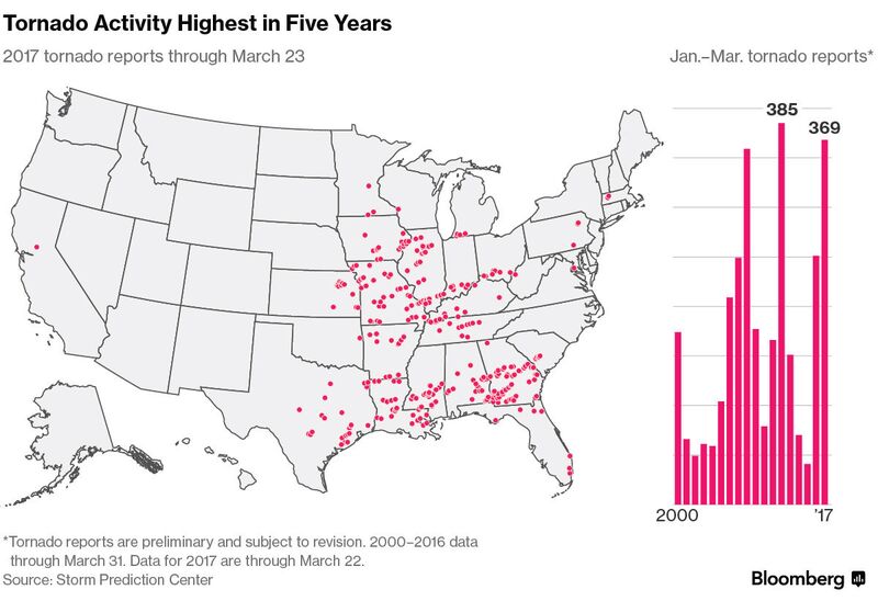 23 March, 2017. Another wave of tornado-spawning thunderstorms is set to rip across the Great Plains and South this week, putting the U.S. within reach of a record year for life-threatening twisters.
Severe storms will drench a swath of the country from Texas to Mississippi over the next five days, according to the U.S. Storm Prediction Center. Through Thursday, 369 tornadoes have been reported across the country, the most in five years and more than double the normal number of sightings.
An active jet stream and unusually balmy weather are to blame for the burst of deadly tornado activity, the storm prediction center said. Strong winds have dragged storms into the warm, humid air that’s blanketed the eastern half of the nation, creating conditions ripe for a weather phenomenon that leads to at least $400 million in damage a year in the U.S.
“We have a severe threat starting today and continuing for each of the next five days through at least Monday,” said Patrick Marsh, warning coordination meteorologist at the storm prediction center in Norman, Oklahoma. “Through mid-March, we are on a record or near-record pace.”
<...>
Tornado “outbreaks,” or storm systems that spin out multiple funnels in a limited time and area, are becoming more frequent in the U.S., according to study published in the journal Science in December. Still, the trend isn’t consistent from what some models predicted would result from global warming, the study found.
This could mean climate change isn’t having an impact on tornado numbers, or it may be because scientists just haven’t figured out what effect it’s having, lead author Michael Tippett, a senior research scientist at Columbia University’s International Research Institute for Climate and Society in Palisades, New York, said in the report.
Rising Costs
One thing’s for certain: Costs associated with tornado damages are rising as the number of people living in the path of twister-producing storms rises. “Since 1980, losses due to severe thunderstorm events in the U.S., which includes tornadoes, hail and straight-line winds, have increased dramatically largely due to socioeconomic effects,” Mark Bove, a senior research meteorologist for Munich Reinsurance America Inc, said in an email.
The system pushing into the central U.S. may create more severe weather as it pushes east, said Bob Oravec, senior branch forecaster with the Weather Prediction Center in College Park, Maryland.
“It definitely is going to have the potential for a multi-day event,” Oravec said.
And it could just be the first of several such systems, he said. Long-range models show the potential for a train of storms through the central U.S. for the next few week. Source:Source: bloomberg.com
Is the number of tornadoes increasing in US? ZetaTalk Rights Again?
I made this infographic using D3.js. Tornadoes data taken from here: spc.noaa.gov
Apr 1, 2017
Stanislav
Severe weather data - Damaging wind data: NOAA/NWS Storm prediction center
Damaging winds are often called “straight-line” winds to differentiate the damage they cause from tornado damage. Strong thunderstorm winds can come from a number of different processes. Most thunderstorm winds that cause damage at the ground are a result of outflow generated by a thunderstorm downdraft. Damaging winds are classified as those exceeding 50-60 mph.
Damage from severe thunderstorm winds account for half of all severe reports in the lower 48 states and is more common than damage from tornadoes. Wind speeds can reach up to 100 mph and can produce a damage path extending for hundreds of miles.
Since most thunderstorms produce some straight-line winds as a result of outflow generated by the thunderstorm downdraft, anyone living in thunderstorm-prone areas of the world is at risk for experiencing this hazard.
People living in mobile homes are especially at risk for injury and death. Even anchored mobile homes can be seriously damaged when winds gust over 80 mph.
Source: nssl.noaa.gov
I created these maps using QGIS and D3.js
Apr 5, 2017
KM
http://www.huffingtonpost.ca/2017/04/04/newfoundland-blizzard_n_158...
Newfoundland Blizzard Brings In Record Amounts Of Snow
The first day of spring was two weeks ago, but winter is far from over in Newfoundland.
A powerful storm swept across the province this week, and another 75 centimetres of snow is expected by Tuesday evening. Over 97 centimetres was dumped on Gander over the weekend. To put that number in context, Toronto saw 81 centimetres of snow over the entire winter, according to The Weather Network.
Gander broke the snowfall record for March with a total of 200 centimetres, and is on track to break April's previous record of 97 centimetres, VOCM reported.
People trying to get to work have faced some unique challenges.
Flights have been cancelled at the St. John's airport, and many highways are nearly impassible. In Gander, a snow plow and ambulance got stuck in the snow, CBC News reported.
Those travelling by boat didn't fare any better.
Apr 5, 2017
Stanislav
For first time in 33 years, March was colder than February in Washington
3 April, 2017. Washingtonians will remember March for a rare, weird and confusing reversal in the usual progression of the seasons: It was colder and more winter-like than it was in February.
Following February’s record-shattering warmth, many believed winter was over. Flowers were in the bloom, and days in the 70s outnumbered those in the 40s.
A record high of 80 degrees on March’s first day only reinforced the notion that winter had caved to spring. Washington’s famed cherry blossoms were on track for their earliest bloom in recorded history.
But the warmth of February and to begin March typified what scientists have called a “false spring,” because — more often than not — the true character of the season eventually reveals itself.
In March’s second week, a sneaky and strong cold snap roared into town, and winter was back in full force. Temperatures plummeted, a cement-like mass of snow and ice poured down, and about half the cherry blossoms perished.
The cold eased in the month’s final third, the cherry blossoms showed off a muted peak, and finally spring was here to stay.
The month closed a full half degree colder than February, marking the first time the months have been reversed since 1984. Since records have been maintained in Washington, dating back to 1872, March has averaged as cold or colder than February just eight times.
What makes this situation even stranger is March’s average temperature was still 0.4 degrees warmer than normal. But February was so mild, 8.7 degrees above normal, that even average temperatures in March would’ve matched it.
March’s average temperature of 47.2 marked the 10th warmer-than-normal month in a row in Washington.
Precipitation (rain and melted snow) totaled 3.19 inches, .29 inches below normal, but represented the wettest single month since last June. The total matches 2007 and is the eighth-driest of the 2000s.
The two inches of mid-month snow amounted to 0.7 inches above normal and marked our snowiest month since February 2016. Baltimore picked up slightly more at 2.3 inches, and Dulles tallied 5.7 inches.
Here is a listing of the March extremes in Washington:
It’s funny to see our warmest day in March being on the first of the month, with the coldest weather being within a week of the start of spring instead. The 0.96 inches of rain we logged on Friday (March 31) marked the single wettest day since Dec. 6. Six “daily” records were broken at our three airports during the month.
March records
Dulles International Airport
BWI
Source: washingtonpost.com
California snowpack is one of the biggest ever recorded, and now poses a flooding risk
<...>
30 March, 2017. He plodded across the white mounds, plunged his metallic pole into the powder beneath him, pulled it out and made his proclamation: 94 inches deep.
The 2016-17 winter created one of the largest snowpacks in California’s recorded history and it’s loaded with enough water to keep reservoirs and rivers swollen for months to come.
“For recreation, there’s a lot of pent-up demand for spring touring,” Gehrke told reporters and viewers watching on a social media live stream. “Clearly this is going to be a good year for it. People have to be aware that conditions are different and they can’t expect the same conditions they had a couple years ago.”
With reservoirs and rivers already full from months of rain, the addition of melting snow will likely push water over the banks in some communities and cause flooding, said David Rizzardo, chief of snow survey and water supply forecasting for the state Department of Water Resources.
<...>
This year’s snowpack is the seventh-deepest since 1950 and biggest since 2011, said state hydrologist Mike Anderson.
When Gehrke stood at that same spot in Phillips in 2015, it was a bare field of dirt, grass and weeds.
“The difference is visually stunning, but it’s the pattern of West Coast weather,” Gehrke said. “The winter weather in California is feast or famine. We have very dry years followed by extremely wet years.”
<...>
The governor declared a state of emergency and instituted strict water use restrictions that remain in place for some people today.
But with all of that snow piled in the Sierra this year — it equates to more than 46 inches of rain when it melts — many water agencies up and down the state argue that it’s time to declare the drought over and lift those restrictions. California has been inundated with more than 30 atmospheric river events — warm, Pacific-based storms that drop massive amounts of rain — since October and is on track for one of its rainiest water years (measured from Oct. 1 — Sept. 30) in history.
<..> Source: latimes.com
March madness: Last month was colder and snowier than usual (Nova Scotia, US)
3 April, 2017. 98.8 centimetres of snow fell at the Halifax Stanfield International Airport last month
March turns messy with snow, ice and freezing rain on the way
Messy March nor'easter to bring snow, slush and rain Tuesday
Have the impression that this past March was colder and featured more of the white stuff than usual? You'd be right!
Most weather observation stations finished the month with mean daily temperatures well below climate normals and snowfall amounts well above. Source: cbc.ca
Apr 5, 2017
Stanislav
Reality of the worst drought since 1945 peaking in parts of Africa
17 March, 2017. Millions of people in over a dozen countries in the Horn of Africa and southern Africa are facing the peak effect of severe drought that hit the regions resulting in famine.
Worst among the countries are Somalia, South Sudan, and Nigeria in West Africa who are part of the more than 20 million people estimated by the United Nations to be facing severe famine and starvation in the world.
The World Health Organisation (WHO) warned that Somalia is at risk of its third famine in 25 years after the previous crisis in 2011 that killed about 260,000 people.
The Horn of Africa is facing its third consecutive year of drought causing thirst and hunger, decimating livestock, destroying livelihoods, spreading disease and triggering large scale population movements.
Somalia’s neighbour Kenya is also facing drought in half of the country – 23 of its 47 counties nationwide.
United Nations humanitarian chief Stephen O’Brien described the crisis to the Security Council as the largest since the second world war in 1945, and an amount of $4.4 billion is needed “to avert a catastrophe” in Somalia, South Sudan, Nigeria and Yemen in the Arabian Peninsula.
For the other drought-ridden countries including Lesotho, Madagascar, Malawi, Mozambique, Namibia, South Africa, Swaziland, Tanzania, Zambia and Zimbabwe, the Food and Agriculture Organization (FAO) launched an appeal last year for emergency aid estimated at 109 million dollars to cover 23 million people.
Source of the Crisis
The U.N. humanitarian chief Stephen O’Brien clearly stated after a visit that the famine in South Sudan is man-made due to the three-year civil war in the world’s newest country which is facing a worse situation.
Like South Sudan, the famine in northeastern Nigeria is as a result of the seven-year insurgency of the Islamist sect Boko Haram killing over 20,000 people and with at least 2.6 million people displaced and 5.8 million in dire need of humanitarian aid.
The Horn of Africa countries are facing their third consecutive year of drought.
Ethiopia is experiencing below average rains in the southern and eastern parts of the country caused by the negative Indian Ocean dipole and La Niña leading to drought.
This is a repeat of last year when drought caused by the El Niño climate phenomenon left 10.2 million people hungry and several hundred thousand of animals killed.
Somalia is also facing the brunt of the climate change coupled with the Islamist group al-Shabaab insurgency which is battling the UN-backed government for over a decade.
According to the U.N., 6.2 million people in Somalia need humanitarian assistance and protection, including 2.9 million who are at risk of famine and require immediate help.
During the previous famine in 2011, humanitarian response was slow and nearly 260,000 people died before the famine was officially declared in July.
For Kenya, the climate change is causing drought which is affecting 23 of its 47 counties in the country.
The ten southern Africa countries (Lesotho, Madagascar, Malawi, Mozambique, Namibia, South Africa, Swaziland, Tanzania, Zambia and Zimbabwe) are also facing the brunt of the El Niño climate phenomenon. Source: africanews.com
Droughts in East Africa becoming more frequent, more devastating
17 March, 2017. If the current drought in the East Africa brings a sense of déjà vu, it’s because we’ve been here before – several times.
This is a region where the global forces of climate change, forced migration, and volatile food supply converge, resulting in severe hunger and, at worst, famine. However, while drought is not new, it has become increasingly frequent.
As the UN’s International Fund for Agricultural Development notes: “From 2005, 2006, 2008, 2011, 2015, 2016 and now 2017, datelines change but the stories of unimaginable hardship, death and depravation remain largely the same.”
As with the frequency, the severity has also intensified. The 2011 East African drought was reportedly the region’s worst for 60 years. But while that crisis affected over 12 million people, today’s has already left an estimated 12.8 million severely food insecure. And things are expected to worsen in the coming months with low rainfall forecast from March to May.
According to the UN Office for the Coordination of Humanitarian Affairs (UNOCHA), today’s situation is so widespread because three consecutive years of diminished food production has exhausted people’s capacity to cope with another shock, while access constraints, rising refugee numbers and outbreaks of communicable diseases in the greater region add to the pressures.
Conflict is another key factor as both a driver and result of the drought. It is no coincidence that it is in South Sudan and Somalia – where conflict has led to millions of displacements, made it harder to cultivate land and hampered humanitarian access – that people are in most danger.
This February, South Sudan, which has been at war since 2013, became the first country in six years to declare a famine. UN agencies say 100,000 people there are on the verge of starvation and almost 5 million – more than 40% of the country’s population – are in need of urgent assistance. In Somalia, where 258,000 people died in the world’s previous famine in 2011, further starvation looks like a distinct possibility again.
At the same time, drought has also aggravated existing tensions in places such as the Rift Valley in Kenya where increasingly scarce resources has led to growing violence between pastoralists and farmers. Source: africanarguments.org
Apr 5, 2017
Derrick Johnson
'I've never seen anything like it': Astonishing footage shows truck drivers passing through NSW floodwaters as abandoned cars and caravans float past
In almost every flood there's a handful of motorists who push their luck too far.
And a number of truck drivers braving a raging river have come up nice and close to some cars left abandoned by their seemingly overeager owners.
The 'truckies', who took on the overflowing Tweed River in New South Wales, were forced to dodge a number of waterlogged cars and caravans left floating in the floodwater.
Video of the vehicles taking on the river was posted to popular Facebook page Dash Cam Owners Australia.
Taken last Friday, when the flooded roads were open to large trucks, the drivers were forced to manoeuvre around other vehicles which hadn't fared so well in the water.
Following each other in convoy, the 'truckies' can be heard remarking about the cars which have been abandoned.
'I've never seen anything like this,' one driver said as he passed two vehicles.
Vision has emerged of truck drivers dodging cars and caravans abandoned in the Tweed River, in New South Wales, after it flooded last week
'I've never seen anything like this,' one truck driver said as he passed two abandoned vehicles
Showing how dangerous the floodwaters are, even a large caravan was no match for the rising Tweed River.
Laying alongside it is a small white car, which has seemingly been turned around by the power of the floods.
In the distance another smaller truck also appears to have been washed away into a field by the force of the floods.
The incredible vision of the trucks taking on the floodwater has been viewed close to 328,000 times on Facebook.
Apr 6, 2017
jorge namour
Wild weather across the country has caused flooding, slips and evacuations, especially in Edgecumbe, Bay of Plenty. Here are the developments: NEW ZEALAND
April 6 2017
https://www.tvnz.co.nz/one-news/new-zealand/police-patrol-edgecumbe...
Bay of Plenty township of Edgecumbe evacuated, forcing 600 residents to leave - NZ STUFF
5 APRIL 2017. The entire township of Edgecumbe in the Bay of Plenty is being evacuated due to rising water on the Rangitaiki River. Ross Boreham of the Whakatane District Council said around 600 homes were being evacuated. Around 2000 people are being told to leave. It is said to be a one-in-500-year event, RNZ are reporting.
IMAGE: Edgecumbe residents are being evacuated to Whakatane. GOOGLE MAPS.
http://i.stuff.co.nz/national/91262924/bay-of-plenty-township-of-ed...
Apr 6, 2017
Ovidiu Pricopi
More than 400 icebergs have drifted into the North Atlantic shipping lanes over the past week in an unusually large swarm for this early in the season, forcing vessels to slow to a crawl or take detours of hundreds of kilometres. Experts are attributing it to uncommonly strong counter-clockwise winds that are drawing the icebergs south, and perhaps also global warming, which is accelerating the process by which chunks of the Greenland ice sheet break off and float away. https://www.theguardian.com/environment/2017/apr/06/huge-fleet-iceb...
Apr 7, 2017
KM
http://strangesounds.org/2017/04/400-meters-of-road-collapse-as-flo...
400 meters of road collapse as flooding apocalypse destroys 80% of the city of Comodoro Rivadavia, Argentina
One of the most important cities of Patagonia in terms of population, Comodoro Rivadavia, is being literally destroyed by flooding and strong winds since beginning of April 2017.
The worst rainfall in 40 years – the bad weather isn’t finished yet – has triggered 1 dead, thousands of evacuations, 2000 homeless, tens of injured, large material losses such as the collapse of a 400-meter road, isolating residents from the rest of the world.
In the above video, the road collapse in a neighborhood of the city of Comodoro Rivadavia has isolated lots of families from the rest of the world. But other avenues were also washed away by the torrential rains and mudslide:
Comodoro Rivadavia is a city in the Patagonian province of Chubut in southern Argentina.
Authorities estimate that it has experienced a “80% destruction” after it suffered a week of historic torrential rains and strong winds.
Within just a few days the city experienced more rain that it usually receives in 12 months.
Floods and mudslides swept away bridges and parts of roads and major highways after heavy rains started on March 29 and continued without a break for several days.
Thousands have been evacuated and at least 2 000 made homeless. Here a few pictures of the apocalyptical situations in Argentina:
Apr 9, 2017
Stanislav
Is the number of tornadoes increasing in Europe?
To be objective it is necessary to make some remarks:
24 May, 2013. ‘These last years, we see an increase in the number of tornadoes being reported in Europe,’ added Groenemeijer. ‘But, it is impossible to say whether a real increase has occurred. The rise in the number of reported tornadoes is almost certainly due to increased efforts to collect such data, supported by the EWENT project.’ Source: horizon-magazine.eu
26 September, 2014. After 1990, there is an increase in the number of reports over entire Europe, due to increased data collections efforts and increased public awareness. Source: bogdanantonescu.squarespace.com
Data source: ESWD: European Severe Weather Database. I made this graph using D3.js
Distribution and statistics on tornadoes in Argentina
23 January, 2013. Google translate. Undoubtedly, one of the people with the greatest knowledge, ability to analyze and trajectory in research on tornados in Argentina is Dr. María Luisa Altinger. Researcher at CONICET, a consultant for both state and private agencies, was responsible for the analysis of the tracks of the tornadoes of April 4, 2012 in Greater Buenos Aires.
<...>
Has the frequency of tornadoes increased today?
Clearly, from 2000 onwards, there is a significant increase in the occurrence of severe weather and seasonal events. Thus, it could indicate an increase in the number of days with severe events, perhaps as a consequence of climate change (but the influence of the increase in population, and therefore a greater number of records).
Now, it should be noted that the chart does not show an increase in the number of tornadoes since the measure is per day. That is, in 1993 300 tornados occurred in one night, but the graph takes as a measure that it was "1 night" and not that it was "300 tornados".
<...>
As a summary, let's review some interesting facts that help us to better understand the reality regarding the level and intensity of storms that we have in our country:
- The world's strongest storms occur in Argentina, specifically east of the Andes, according to NASA. He reached this conclusion through studies based on data from the Tropical Rainfall Measurement Mission (TRMM).
- From 1930 to 2009, in Argentina, there were 1194 severe storms, 507 tornadoes and possible tornadoes and 117 storms with severe hail damage. Due to the low radar coverage (even today) the actual figures are likely to be much higher.
- Only in Buenos Aires, at least one village per year is affected directly by tornadoes.
- Tornadoes are recorded between 10 and 15 days per annual season.
- 50% of tornadoes in Argentina are EF1, while 30% are of EF2 scale. Source: pronosticoextendido.ne
20 November, 2015. Meteorologist Luisa Altinger is a pioneer in the study of tornadoes in Argentina. Its records date back to 1971. According to its database, tornadoes have been detected all over the country except Patagonia. Source: lavoz.com.ar
Apr 10, 2017
Stanislav
Cuba Faced With Worst Drought in 115 Years
Two people filling containers with water at a neighbor's house, in the province of Ciego de Avila, Cuba on Apr. 3, 2017. EFE/Alejandro Ernesto. Source: aldianews.com
12 March, 2017. Cuba is undergoing not only animal and human water consumption but is now directly affecting food security.
Cuba is facing its worst drought in 115 years. An abrupt intensification of the phenomenon since the 1960s and predictions of prolonged dry periods going forward, demand a change of vision in dealing with the problem.
According to the World Food Program (WFP) and UNDP (UNDP) officials, it is a sensitive area such as animal and human water consumption and agriculture, with a consequent negative impact on food security. Experts are pessimistic about the overall global scenario, but in the case of Cuba, the situation is even more challenging because of its location in a region negatively affected by ever more frequent violent natural phenomena.
In order to reduce the negative effects of drought, international organizations such as the UNDP and WFP are helping the country develop effective relationships between information obtained from monitoring and forecasting services and responses.
According to the UNDP, sustainable and inclusive human development is essential to combat climate change. It is necessary to assess environmental sustainability and the rational use of resources to address the drought and food security issues in Cuba.
Water shortages currently affect 70 percent of the national territory (more than one million people are affected) and negatively impact on agriculture.
<...> Source: plenglish.com
Sri Lanka's worst drought in 40 years will leave lasting impact
14 March, 2017. Sri Lanka is in the midst of its worst drought in decades. Rain shortages since October have created a humanitarian and economic crisis that is now affecting more than 1.2 million people. More than 900,000 people are in “urgent need of food assistance,” while 80,000 of them may need “urgent life-saving support,” according to a March 7 draft assessment acquired by IRIN.
The drought has affected all but two of the country’s 25 districts in all nine provinces, as well as all aspects of life. It highlights the reverberating consequences of disasters, but the biggest issue at the moment is the shortage of Sri Lanka’s water-intensive staple crop – rice.
“The biggest harvest of the year has just finished, and it’s been a massive failure for most farmers living in areas crippled by the drought,” Chris McIvor, country director for Save the Children in Sri Lanka, said in a press release.
In fact, the harvest was the worst in 40 years, down 63 percent from the average. The drought had damaged land so badly, according to the World Food Program, that by November farmers had cultivated only 35 percent of the country’s rice paddies.
“The nation’s food supply has taken a huge hit, which in turn has caused prices to rise,” McIvor said. “As a result, many of the poorest families are struggling to feed their children, often choosing to eat fewer and smaller meals, and cut down on nutritious foods like meat and vegetables.” Source: humanosphere.org
The worst drought in a century (Kerala, India)
13 March, 2017. Repeat failure of the monsoons may have heralded the worst-ever drought in in Kerala in over 100 years. Revenue Minister E Chandrasekharantold the State Assembly on Wednesday that vast tracts of farmland have been decimated.
The crop loss estimated is to be ₹225 crore, over 30,353.06 hectares. Paddy farmers are the worst hit, staring at damage worth ₹106 crore over an area of 26,499.42 hectares.
Other crops, including coconut, banana, vegetables and cash crops have not been spared. The State government anticipated a significant drop in agricultural output, with grave implications for the economy and practically every sphere of activity. Source: thehindubusinessline.com
With the monsoons failing the region last year, Karnataka, Kerala and Tamil Nadu (India) are facing their worst drought in recent history.
4 March, 2017. South India is staring at an acute drinking water crisis.
After the failure of both the south-west and the retreating north-east monsoons, three southern states are in the midst what officials are calling the “second-worst drought” in history, after the dry spells of the 1960s.
Across Karnataka, Tamil Nadu and Kerala, reservoirs are so dry that even drinking water is hard to come by in several regions. Source: scroll.in
Apr 10, 2017
Howard
Violent Dust Devil Engulfs Soccer Match in Mexico (Apr 3)
An intense dust devil ripped through a soccer match in Tlatlauqui, Mexico, earlier this month.
The mini-cyclone was powerful, pulling dust and debris in from across the field.
The players had to crouch down and cover their faces to prevent dust and sand from getting in their eyes, noses and mouths.
A month prior, a soccer game was interrupted by a large dust devil in Guatemala.
Sources
https://www.washingtonpost.com/news/capital-weather-gang/wp/2017/04...
http://www.dailymail.co.uk/news/article-4292620/Footballers-kickabo...
Apr 15, 2017
KM
http://www.tehrantimes.com/news/412608/Death-toll-rises-to-35-in-Ir...
Death toll rises to 35 in Iran flood, landslide incidents
TEHRAN — Severe flood and landslide in western and northwestern parts of Iran have so far claimed 35 lives and left 8 missing.
Heavy rain which started on Friday morning caused flood in the afternoon and unfortunately the northwestern cities of Azarshahr and Ajabshir hit the hardest by the flood, ISNA quoted Ismail Najjar, head of the Crisis Management Organization as saying on Saturday.
Seven cars have gone missing in Azarshahr, he regretted, adding, despite the warnings some people were reluctant to leave the area.
According to East Azarbaijan crisis management organization up to now, 14 have died and at least 3 gone missing in Azarshahr and some 4 individuals are missing and 15 are dead n Ajabshir.
“Some bridges are reportedly damaged in West Azarbaijan province and sadly a 12-year-old boy is taken away by the flood while biking,” he explained.
Moreover, 4 died in a landslide triggered by the flood in Saqqez, Kordestan province, and one passed away in Baneh, he said.
So far, some 1,100 have received relief services, 77 provided with emergency accommodation, and 6 transferred to hospitals in 32 cities and villages, Najjar noted, adding, water was pumped out of 48 houses as well.
Apr 16, 2017
KM
http://strangesounds.org/2017/04/dimmitt-tornado-texas-video.html
Monster 1.7-kilometer-wide tornado almost eat up Dimmitt, Texas – Amazing stormchaser videos
On Friday April 14, 2017, an enormous tornado swept across Texas Panhandle.
The monster EF3 twister was as wide as 1.7 kilometers as it almost swallowed Dimmitt, Castro County during a 7,2 km touchdown with speeds reaching 225 km / h. Now watch this tornado as captured b plenty of storm hunters:
Luckily, the tornado didn’t touch a region where lots of residents live. Many managed to escape before the storm. Here a few pictures of the consequences of the tornado:
Always be ready!
Apr 17, 2017
KM
http://www.cbc.ca/news/canada/saskatoon/lloydminster-slammed-snow-s...
Lloydminster slammed with 42 cm of snow during weekend storm
Environment Canada believes snow should disappear within next few days
A serious snowfall blanketed central and northern Saskatchewan with snow this weekend.
A serious winter storm over the weekend covered central and northern Saskatchewan with a thick blanket of snow.
Over four days, Lloydminster was hit with 42 centimetres of snow. Buffalo Narrows and La Ronge received around 20 centimetres, while Flin Flon received 28 centimetres.
The snow created icy road conditions and poor visibility.
Despite warm temperatures, Environment Canada believes the snow will be around for the next several days.
"We can still see the band of snow on satellite imagery," said weather specialist Mark Melsness. "There's still a bright band of white left on the ground."
The province's Water Security Agency is monitoring the situation. For now, the agency said it is not concerned about flooding caused by the sudden snow dump.
Apr 18, 2017
KM
http://www.cbc.ca/news/canada/montreal/flooding-continues-in-parts-...
Flooding continues in parts of Quebec with more rain expected
In one municipality, hundreds of homes are either flooded or surrounded by water
Hillary Porter pulls her dogs along in a boat in the town of Rigaud, Que., west of Montreal, on Thursday, following flooding in the area. (Canadian Press/Graham Hughes)
Authorities are on alert for additional flooding as heavy rains continue to batter parts of Quebec.
The town of Rigaud, Que., is hardest hit, with 343 homes either flooded or surrounded by water. Provincial police are still patrolling the municipality, which declared a state of emergency on Thursday afternoon.
Some 53 municipalities have experienced enough flooding this week to qualify for provincial aid, according to a news release issued by the Quebec government.
That's in addition to another 19 municipalities already eligible for financial assistance after being hit by flooding earlier this spring.
State of emergency
On Thursday, the town of Rigaud, Que., told some of its residents to leave their homes as roads and houses began to flood.
Around 7,500 people live in the municipality, which is located 25 kilometres west of the island of Montreal.
Police attach a boat to their vehicle while dealing with flooding in Rigaud, Que.
Rigaud Mayor, Hans Gruenwald Jr., says with more rain falling on Friday, he can't guarantee emergency services to those who refuse to leave their homes.
Residents were advised to head to the local library if they needed a safe place to stay. Family pets aren't being allowed in the library, but a number of local kennels have offered discounted rates.
If anyone needs to reach the municipality in the event of an emergency, they can call 450-451-0869, extension 235.
In Montreal, the city is keeping its website updated with the latest flood information.
In the borough of Pierrefonds-Roxboro, minor flooding has been reported, but the situation is under control according to city officials. In the L'île-Bizard-Sainte-Geneviève borough, sandbags have been distributed to residents. Ahuntsic-Cartierville and Sainte-Anne-de-Bellevue are listed as "high-risk", but no flooding has been reported.
The Rivières des Prairies area is also considered a high risk for flooding. In Laval, Que., volunteers are going door-to-door to inform residents in certain areas of Sainte-Dorothée and Laval-sur-le-Lac about the risks of local flooding.
Montreal had five millimetres of rain Thursday night and will see another five millimetres Friday, according to Environment Canada forecaster Denis Thibodeau. In places like the Laurentians, the Eastern Townships and Beauce, Que., can expect heavier precipitation on Friday.
Those areas will see anywhere from 10 to 15 millimetres of rain.
The Quebec City area could see between 15 and 20 millimetres over the next 24 hours.
Thibodeau said Montreal has received double the average rainfall so far in April. The average for this month is 67.7 millimetres, but even before the precipitation accumulated over the last 24 hours, there had already been 130 millimetres of rain this month.
"We're well over the normal," said Thibodeau.
Some residents of Rigaud, Que. have been asked to leave their properties as water levels continue to rise.
Apr 21, 2017
Stanislav
California: From one of worst drought in history to one of wettest-ever year
I created this graph using D3.js. Data source: United States Drought Monitor.
Source: cdec.water.ca.gov
ZetaTalk: Weather Extremes
written July 29, 2005
We warned at the start of ZetaTalk, in 1995, that unpredictable weather extremes, switching about from drought to deluge, would occur and increase on a lineal basis up until the pole shift. Where this occurred steadily, it has only recently become undeniable. ZetaTalk, and only ZetaTalk, warned of these weather changes, at that early date. Our early warnings spoke to the issue of global heating from the core outward, hardly Global Warming, a surface or atmospheric issue, but caused by consternation in the core.
ZetaTalk: Weather Extremes
California sets new all-time record for northern Sierra rainfall
May, P. (13 April, 2017.) "With another storm Thursday, the Golden State has its wettest-ever year <...>
With one more soaking-wet storm front dumping its stuff special-delivery over Wednesday night, California woke up on Thursday to a new all-time record for rainfall, as measured in the all-important “Northern Sierra eight-station index,” a catchment area that pretty much defines the Golden State’s water-level health. <...>"
Source: May, P. (2017, April 13). California sets new all-time record for northern Sierra rainfall. Retrieved April 16, 2017, from mercurynews.com
From extreme drought to record rain: Why California's drought-to-deluge cycle is getting worse
20 April, 2017. "California’s climate has long been dominated by cycles of intense dry conditions followed by heavy rain and snow. But never before in recorded history has the state seen such an extreme drought-to-deluge swing. <...>"
Source: "From extreme drought to record rain: Why California's drought-to-deluge cycle is getting worse." Los Angeles Times. Los Angeles Times, n.d. Web. 20 Apr. 2017. latimes.com
California storms: This rainy season now ranks 2nd all time in 122 years of record
Gomez, M. (2017, April 07). "<...> After relatively modest rainfall in March, this season now ranks as the second wettest in 122 years of record-keeping, according to data released Thursday by federal scientists.
Between October 2016 and March 2017, California averaged 30.75 inches of precipitation, the second-highest average since such records began being kept in 1895, according to the National Centers for Environmental Information, part of the National Oceanic and Atmospheric Administration. <...> "
Gomez, M. (2017, April 07). California storms: This rainy season now ranks 2nd all time in 122 years of records. Retrieved April 21, 2017, from mercurynews.com
Apr 21, 2017
Yvonne Lawson
St. John's, Newfoundland, Receives Record-Breaking 60 Consecutive Hours of Freezing Rain, Turning It into a Winter Wonderland
(Instagram/goob709)
Winter made a vicious return to Newfoundland in recent days, where freezing rain fell for a record two and a half days in one spot.
The record was broken at St. John's International Airport in southeastern Newfoundland, where local meteorologists said freezing rain was reported for 60 consecutive hours from Thursday through Sunday, according to the Weather Network. This event broke the previous record of 37 hours reported March 2-4, 1998, local meteorologist Rodney Barney tweeted.
"Newfoundland was under a cold high-pressure system located to its north during the weekend," said weather.com meteorologist Chris Dolce. "A narrow band of light precipitation from an offshore low-pressure system interacted with the cold air, resulting in a lengthy period of freezing rain."
It wasn't just St. John's – the nearby town of Paradise was also hit hard by the ice storm. Still, no power outages were reported in the area Monday morning, although some schools opened late, CBC News said.
Source and some great pictures: https://www.wunderground.com/news/newfoundland-freezing-rain-ice-st...
Apr 24, 2017
KM
http://www.dailymail.co.uk/news/article-4443274/Fire-rips-Russian-n...
Fire rips through Russian 'nuclear town' built to supply weapons-grade plutonium
Residents of a Siberian town have complained of choking from the smoke of wildfires as fumes spread inside flats and houses.
Photos of Zheleznogorsk, a town of 84,800 people that is closed to outsiders, show flames close to residential buildings.
The town, 39 miles from major city Krasnoyarsk, retains nuclear facilities for storage although the production of weapons-grade plutonium was reported as having stopped in 2010.
Wildfires have hit Siberia's Zheleznogorsk, which retains nuclear facilities for storage although the production of weapons-grade plutonium was reported as having stopped in 2010
Photos of Zheleznogorsk, a town of 84,800 people that is closed to outsiders, show flames close to residential buildings
Residents of the south-central Siberian town have complained of 'choking' due to smoke from the fires
It is believed, however, that there is no immediate threat to the nuclear facilities, which are built within caverns excavated in the granite mountain on the northern edge of the city.
Local journalists said they could not get details of the fire from the local emergencies ministry, because they town's administration is run from Moscow, 2,100 miles and five time zones to the west, according to the Siberian Times.
Apr 25, 2017
KM
http://strangesounds.org/2017/04/superstorm-us-new-york-texas-panha...
US Superstorm: VERY large, powerful storm system stretching from New York to the Texas Panhandle
This is what a superstorm looks like!
A VERY large, powerful storm system is forming over the United States stretching from New York all the way back to the Texas Panhandle.
It looks like an anomalous “energy rush” of some sort. And the ‘deadly’ superstorm continues to grow. You will/may get downpours, floods, snow, tornado, hail, winds through the weekend from New York to Texas!
This system, based off of these satellite images has the potential to create some very intense storms.
Apr 29, 2017
jorge namour
NBC DFWLike Page
3 hrs
·
Texas Sky Rangers shows the damage to a car dealership along I-20 in Canton.
APRIL 30 2017
http://www.nbcdfw.com/weather/stories/Canton-Car-Dealership-Takes-D...
A Canton car dealership took a direct hit when a twister roared through town Saturday evening.
Interstate 20 Chrysler Dodge Jeep Ram of Canton received widespread damage to a new showroom and maintenance facility. CONTINUE...
APRIL 30 2017
Apr 30, 2017
lonne rey
Winter Storm Ursa Was a Crippling Blizzard in the High Plains; One of Their Heaviest Late-Spring Snowstorms of Record
https://weather.com/storms/winter/news/winter-storm-ursa-rockies-hi...
Winter Storm Ursa brought a crippling, destructive blizzard from the Texas panhandle to Nebraska in the final weekend of April 2017. Ursa caused vehicles to be stranded, downed trees and power lines and whipped up snow drifts up to 8 feet in one of the strongest snowstorms to slam the High Plains so late in the spring.
May 2, 2017
Tracie Crespo
www.msn.com/en-us/weather/topstories/2-more-deaths-blamed-on-floodi...
2 more deaths blamed on flooding in Missouri
ST. LOUIS — Two more people were confirmed dead Tuesday after their vehicles were swept away by floodwaters in Missouri, bringing the death toll from sudden spring flooding in the state to at least five.
The latest deaths occurred in an area of southeast Missouri where heavy rains pushed rivers to record levels. The flood fight also continued near St. Louis, where sunny skies belied an ominous forecast: More rain that could send the bulging Meramec River to record heights and potentially into hundreds of homes.
The Missouri State Highway Patrol reports a 60-year-old man was found dead late Monday inside a pickup in a ditch along Highway 53, where authorities believe water from the flooded Black River swept the truck off the road. A 69-year-old woman from Harviell was found dead Tuesday on Butler County Road 153, still inside her vehicle that was apparently swept away by water from a flooding creek.
Highway Patrol Sgt. Clark Parrott said motorists sometimes don't realize how dangerous even a small amount of water on the road can be.
"It seems like we go through this every year, and it's just heartbreaking," he said.
The Meramec River already is nearing all-time highs in towns such as Pacific, Eureka and Valley Park, potentially threatening 1,700 homes. As much as 2 inches of rain is forecast Wednesday through Thursday. The National Weather Service predicted that the crest at Eureka will top the record set in December 2015, and Valley Park will tie the mark set that same year.
Much of Missouri was inundated with up to 12 inches of rain over the weekend. More than 270 roads remain closed, including a 57-mile stretch of Interstate 44 from central to southern Missouri, and a 23-mile stretch in suburban St. Louis. The Missouri Department of Transportation said a portion of Interstate 55 in St. Louis County will close before daybreak Wednesday, due to flooding on the Meramec.
About 200 homes have already been damaged by Meramec River floodwater, and another 1,500 are threatened, said St. Louis County emergency management director Mark Diedrich.
The new round of flooding comes just 16 months after a rare December flood swamped the same Meramec River towns, damaging hundreds of homes and badly damaging two sanitary treatment plants.
St. Louis County Police Chief Jon Belmar urged residents behind Meramec River levees to get out if they haven't already. Even if the levees hold, he said, there are dangers.
"The water is filthy," Belmar said at a news conference. "There are all sorts of health issues down there. We strongly urge them to evacuate until we can get this under control."
The Mississippi is a few feet above flood stage north of St. Louis, but major flooding is forecast by the end of the week in towns below where the Meramec spills into the Mississippi, including Ste. Genevieve, Cape Girardeau and Scott City.
Major flooding is now predicted on parts of the Missouri River in eastern Missouri, but because of buyouts in recent years, damage is expected to be minimal.
Amtrak also suspended rail service across Missouri because of flooding. A spokeswoman said the tracks could reopen Saturday.
May 3, 2017