Earth Changes and the Pole Shift
Wild Weather, the Wobble Effect
|
Weather: |
Tides and Whirlpools:
|
"We warned at the start of ZetaTalk, in 1995, that unpredictable weather extremes, switching about from drought to deluge, would occur and increase on a lineal basis up until the pole shift. Where this occurred steadily, it has only recently become undeniable. ZetaTalk, and only ZetaTalk, warned of these weather changes, at that early date. Our early warnings spoke to the issue of global heating from the core outward, hardly Global Warming, a surface or atmospheric issue, but caused by consternation in the core. Affected by the approach of Planet X, which was by then starting to zoom rapidly toward the inner solar system for its periodic passage, the core was churning, melting the permafrost and glaciers and riling up volcanoes. When the passage did not occur as expected in 2003 because Planet X had stalled in the inner solar system, we explained the increasing weather irregularities in the context of the global wobble that had ensued - weather wobbles where the Earth is suddenly forced under air masses, churning them. This evolved by 2005 into a looping jet stream, loops breaking away and turning like a tornado to affect the air masses underneath. Meanwhile, on Planet Earth, droughts had become more intractable and deluges positively frightening, temperature swings bringing snow in summer in the tropics and searing heat in Artic regions, with the violence of storms increasing in number and ferocity."
From the ZetaTalk Chat Q&A for February 4, 2012:
The wobble seems to have changed, as the temperature in Europe suddenly plunged after being like an early Spring, Alaska has its coldest temps ever while the US and much of Canada is having an extremely mild winter. India went from fatal cold spell to balmy again. Has the Earth changed position vs a vs Planet X to cause this? [and from another] Bitter cold records broken in Alaska - all time coldest record nearly broken, but Murphy's Law intervenes [Jan 30] http://wattsupwiththat.com/2012/01/30/bitter-cold-records-broken-in-alaska Jim River, AK closed in on the all time record coldest temperature of -80°F set in 1971, which is not only the Alaska all-time record, but the record for the entire United States. Unfortunately, it seems the battery died in the weather station just at the critical moment. While the continental USA has a mild winter and has set a number of high temperature records in the last week and pundits ponder whether they will be blaming the dreaded "global warming" for those temperatures, Alaska and Canada have been suffering through some of the coldest temperatures on record during the last week.

There has been no change in the wobble pattern, the wobble has merely become more severe. Nancy noted a Figure 8 format when the Earth wobble first became noticeable, in early 2005, after Planet X moved into the inner solar system at the end of 2003. The Figure 8 shifted along to the east a bit on the globe between 2005 and 2009, (the last time Nancy took its measure) as Planet X came closer to the Earth, encountering the magnetic N Pole with a violent push earlier in the day. But the pattern of the Figure 8 remained essentially the same. So what changed recently that the weather patterns became noticeably different in late January, 2012?
The N Pole is pushed away when it comes over the horizon, when the noon Sun is centered over the Pacific. This regularly puts Alaska under colder air, with less sunlight, and thus the historically low temps there this January, 2012 as the wobble has gotten stronger. But by the time the Sun is positioned over India, the N Pole has swung during the Figure 8 so the globe tilts, and this tilt is visible in the weather maps from Asia. The tilt has forced the globe under the hot air closer to the Equator, warming the land along a discernable tilt demarcation line.
The next loop of the Figure 8 swings the globe so that the N Pole moves in the other direction, putting the globe again at a tilt but this time in the other direction. This tilt is discernable in weather maps of Europe, again along a diagonal line. Depending upon air pressure and temperature differences, the weather on either side of this diagonal line may be suddenly warm or suddenly cold. The tilt and diagonal line lingers to affect much of the US and Canada, but the Figure 8 changes at this point to be an up and down motion, pulling the geographic N Pole south so the US is experiencing a warmer than expected winter under a stronger Sun. Then the cycle repeats, with the magnetic N Pole of Earth pushed violently away again as the Sun is positioned over the Pacific.
From the ZetaTalk Chat Q&A for April 6, 2013:
Would the Zetas be able to let us know what is causing the early break-up of the Arctic Ice, the ice seems to have taken on a swirling pattern at the same time, would this be wobble related? [and from another] http://www.vancouversun.com/news/national/Canada+Arctic+cracks+spectacular+event/8185609/story.html The ice in Canada’s western Arctic ripped open in a massive “fracturing event” this spring that spread like a wave across 1,000 kilometres of the Beaufort Sea. Huge leads of water – some more than 500 kilometres long and as much as 70 kilometres across – opened up from Alaska to Canada’s Arctic islands as the massive ice sheet cracked as it was pushed around by strong winds and currents. It took just seven days for the fractures to progress across the entire area from west to east. [and from another] http://earthobservatory.nasa.gov/IOTD/view.php?id=80752&src=iotdrss A high-pressure weather system was parked over the region, producing warmer temperatures and winds that flowed in a southwesterly direction. That fueled the Beaufort Gyre, a wind-driven ocean current that flows clockwise. The gyre was the key force pulling pieces of ice west past Point Barrow, the northern nub of Alaska that protrudes into the Beaufort Sea.

The Figure 8 formed by the N Pole during the daily Earth wobble has shifted somewhat to the East, due to Planet X positioned more to the right of the Earth during its approach. This was anticipated, and well described in ZetaTalk, the Earth crowding to the left in the cup to escape the approach of Planet X, so the angle between these two planets would change slightly. This shift of the Figure 8 to the East is due to the push against the Earth’s magnetic N Pole occurring sooner each day than prior. Thus instead of occurring when the Sun is high over the Pacific, over New Zealand, it is now occurring when the Sun is high over Alaska. All the wobble points have shifted eastward accordingly.
This has brought a lingering Winter to the western US, and a changed sloshing pattern to the Arctic waters. Instead of Pacific waters being pushed through the Bering Straits into the Arctic when the polar push occurs, the wobble is swinging the Arctic to the right, and then later to the left, creating a circular motion in the waters trapped in the Arctic. Since the Earth rotates counterclockwise, the motion also takes this path. This is yet another piece of evidence that the establishment is hard pressed to explain. They are attempting to ascribe this to high pressure and wind, all of which are not new to the Arctic, but this circular early breakup of ice in the Arctic is new.
Howard
Rare Snowstorm Blankets Northern China During Chinese Summer (May 11)
Source
http://english.cri.cn/11354/2014/05/11/53s825911.htm
May 12, 2014
Howard
Rare Cloud Formation Over the Philippines (May 15)
Resident Holden Kirby Valdez said he has not seen such a cloud formation before.
According to the American Meteorological Society study, the rare cloud formation is called “mammatus clouds,” defined in the study as clouds that appear like “hanging protuberances, like pouches, on the undersurface of a cloud.”
The cloud formation is formed when the sinking air is cooler than the air around it, according to the Earth Observatory of NASA, adding that the sinking air must have a high water or ice content.
Source
http://newsinfo.inquirer.net/602725/rare-cloud-formation-spotted-in...
May 17, 2014
Howard
Georgia Hit by Rare Anticyclonic Tornado (May 15)
Tornadoes usually spin in a counterclockwise direction. A storm survey of an EF-0 tornado that hit Eastman, Georgia Wednesday night showed that the tornado was actually spinning in a "clockwise" motion. That is called an "anticyclonic tornado."
"Our survey team confirmed an EF0 tornado with maximum winds of 80 mph touched down in the south part of Eastman at 1150 pm EDT on May 14th and traveled north approximately 1.75 miles through town. As illustrated below, the storm exhibited anticyclonic (clockwise) rotation, a very rare phenomenon since the vast majority of tornadoes rotate cyclonically (counter-clockwise)," said National Weather Service forecasters in a post on their Facebook page.
11Alive Meteorologist Chris Holcomb also says this is a rare event.
"This might happen one out of every 1,000 tornadoes," he said. "This type of rotation is usually away from stronger rotation within a storm in the rear flank of the rotating system. These anticyclonic rotations are usually weak and don't last long."
Source
http://www.11alive.com/story/news/local/2014/05/16/dodge-county-hit...
May 17, 2014
Howard
Surreal Time Lapse Video of Supercell Forming in Eastern Wyoming (May 19)
During peak tornado seasons, supercell videos are a dime a dozen, but this one out of Wyoming is as if it were straight from a sci-fi movie or another planet.
What you're seeing is a rotating updraft of a supercell. This particular supercell is known as a low precipitation or LP supercell. It's called that because it simply does not produce much precipitation to the ground. In fact, the most frequent precipitation you'll ever see out of these is large hail stones. This is why they are a little dangerous to chase, as you want to make sure you don't get pelted by the hail.
Source
http://www.theweathernetwork.com/news/articles/must-see-surreal-tim...
May 20, 2014
jorge namour
Weather alert, alarm in France and England for "the strongest storms in 50 years." But even in Italy ...
Tuesday, May 20, 2014,
http://translate.google.com/translate?hl=en&sl=auto&tl=en&a...
A new plunge of cold air from the Arctic Circle is affecting Europe at this time, this time further west than what happened last week when the cold weather and are sealed on Italy and the Balkans causing the disastrous flood that put knee in Bosnia, Serbia and Croatia with unprecedented rains over the past 120 years, disastrous floods and, unfortunately, dozens of victims (at least 70 seconds the latest updates, still not final).
This time the bad weather, just as severe, will concentrate in the areas most Western Europe, including the UK, France, Spain and Portugal where since yesterday evening I started heavy rain and spectacular thunderstorms that made fans go crazy British unleashed to publish on social networks photographs of lightning storms out of season. In recent days, the United Kingdom has experienced an intense heat wave that had guaranteed sunny days and warm with highs of over 30 ° C: its the heat has fueled the energy that is now giving rise to extreme events, caused by thermal contrasts due to the clash between the cold air coming in the persistent heat at lower layers.
After the storms of the past few hours in Liverpool and Wirral, especially where there was no damage to the arrows that hit the towns causing collapses and blackouts, now more storms are expected for the next 48 hours. The Met Office has issued a warning especially for Wednesday and Thursday, "models let you imagine scenarios of particular concern, with the strongest storms of the past 50 years, at least since 1960," wrote the British experts. Even in France, Spain and Portugal will have violent storms that can cause storms, floods, and even numerous tornadoes. And 'high risk of another flood, because the most affected areas will fall up to 150mm of rain in a few hours. And this, again one step from Italy but this time not in the east to the west.
Rtavn19218 Be warned, however, that also in Italy from Friday onwards will return to the bad weather, and as we can see from the maps of the rainy forecast for the next few days, will once again end with heavy rainfall especially in the center / north, after a few hours hot ephemeral between Wednesday and Thursday.
To monitor the situation live you can browse our real-time news and the pages of nowcasting: satellites , situation , lightning , radar and webcam . On our facebook page you can find more updates and interact with the editors sending pictures, messages or any kind of reflection. If you want, write us and send us the photos also e-mail address, redazione@meteoweb.it .
Here are some satellite maps and some of the most beautiful photographs of lightning strikes of the past few hours in England:
http://www.meteoweb.eu/2014/05/allerta-meteo-allarme-in-francia-e-i...
May 21, 2014
jorge namour
Record heat in Russia: fear of an agricultural disaster
http://translate.google.com/translate?hl=en&sl=auto&tl=en&a...
http://actualite.lachainemeteo.com/actualite-meteo/2014-05-22-10h51...
News - Published Thursday, May 22, 2014 by The Weather Channel
Depression that caused the severe weather in the Balkans has traced the soft air to Russia. The beginning of this heat wave fears an agricultural disaster.
28 ° C in Moscow yesterday, today 29 ° C and 32 ° C in anticipation of the end of the week. Moscow is affected by a heat wave that could have serious consequences for the Russian economy, but also globally. Temperatures 10 ° C above the seasonal average, which had not been higher since August 2013. Besides the heat, drought is present in the south-east of Russia with a rainfall deficit of 20% over a geographical area known for its cultivation of cereals. Fear mainly the oat market, widely used for livestock feed. Some financiers are already worried about a likely increase in world prices if the weather situation persists, as was the case during the summer of 2012.
Weather forecast: heat and lack of rain
These next ten days ahead of cyclone Moscow region: sun and heat will remain set, with temperatures will not fall below 25 ° C and an almost total lack of precipitation, except for some thunderstorms heat.
Heat wave "red-hot" Russia and the Baltics: tips +33 ° C in Estonia, altered historical records
Monday, May 19, 2014
http://translate.google.com/translate?hl=en&sl=auto&tl=en&a...
http://www.meteoweb.eu/2014/05/eccezionale-ondata-calore-arroventa-...
As we announced in recent days, while the countries of Central Europe and Italy were hit by descent of air masses rather fresh from the North Atlantic and the British Isles, the countries of Eastern Europe and European Russia, the persistence of a massive block of anticyclonic headland, now spintosi with its northernmost elements above 60 ° north latitude, has given rise to an intense
heat wave that is affecting the western sector of European Russia, Belarus, Lithuania, Latvia, Estonia and southern Finland.
The ascent of air masses sub-tropical continental decidedly hot and dry from the arid steppes of Uzbekistan and Kazakhstan, has catapulted the thermometers on values from the height of summer. So much so that the wall of +30 ° C +32 ° C was broken in several places in Russia, the Volga region to Karelia, where the heat is really intense in the central hours of the day. But temperatures above +30 ° C, at this time, are being recorded in the inland areas of the Baltic countries and Finland, where it begins to flow much of the air very hot and dry in these days has just deposited over the vast Sarmatian plains. Note that in many cities, including the western part of European Russia, eastern Finland and Estonia, the threshold of +30 ° C, thanks to the advent of a moderate and "red-hot" ventilation from the south-eastern quadrant , has been largely overcome. On all stands the figure of St. Petersburg that today recorded a maximum temperature of more than +31 ° C, above the already record hot month of +30.9 ° C, established in May 1958.
The charming Russian city improved its record monthly hot, attestandolo over the threshold of +31 ° C. But the new record heat in St. Petersburg is nothing compared to +33 ° C in the shade achieved in Estonia Continue...
May 22, 2014
Ancient Ally
Sheriff reports “highly unusual weather event” at Bellaire Lake Cam...
LARIMER COUNTY, Colo. — A campground at Red Feather Lakes in Larimer County is closed after the sheriff says a “highly unusual weather event” took place Thursday afternoon at Bellaire Lake.
Some reports say the damage at the campground came from a tornado. “However, this certainly may have been caused by a straight wind,” says Sheriff Justin Smith.
The campground is 30 miles west of Fort Collins and the U.S. Forest Service has closed it indefinitely.
More than 100 trees were knocked down as a result of this “high wind event.” The closure includes Molly Lake Trailhead and dispersed campsites along Manhattan Road.
The U.S. Forest Service and Larimer County Emergency Services worked together to evacuate campers and address safety issues.
Clean-up work at the site will begin Friday.
May 23, 2014
jorge namour
Sky fire Lyon FRANCE- PHOTOS VIDEO
News - Published Saturday, May 24, 2014 by The Weather Channel
Incredible photos of the sky Lyon and its surroundings have been taken by our users yesterday
http://translate.google.com/translate?hl=en&sl=auto&tl=en&a...
http://actualite.lachainemeteo.com/actualite-meteo/2014-05-23-12h52...
May 24, 2014
KM
http://www.aljazeera.com/weather/2014/05/sao-paulo-ice-201452011235...
http://www.youtube.com/watch?v=o3JRSyAfHBE
Sao Paulo on ice
A rare hailstorm blankets parts of Brazil’s largest city.
A storm has brought marble-sized hail to Sao Paulo. The city, which is the largest in Brazil and will host the opening game the football World Cup on 12 June, was coated in a layer of ice up to 20cm in places.
Authorities had to send bulldozers in to help clear the streets of the ice. This part of Brazil is subtropical so the city does not actually have any snow ploughs.
The Centre for Emergency Management said the storm broke a dry spell that caused historically low levels at the main dams that supply water to Sao Paulo. The equivalent of 10mm of rain was recorded,
This amounts to a small if crucial addition to the city's water supply. Water levels at Sao Paulo's main reservoir had sunk as low as 10 per cent of its capacity, the lowest level on record. However, the city still faces the possibility of water rationing only weeks ahead of the start of the World Cup.
May 24, 2014
lonne rey
3 people die because of a of cold wave in Bolivia
A cold wave that hit Bolivia since Friday has caused the death of three people and has caused the death of dozens of cattle, while the storms have damaged streets and houses, official sources reported today.
Two homeless people died on Friday in the city of Santa Cruz (East) by a drastic drop in temperatures from 23 to 8 degrees Celsius, due to the cold wave that entered Bolivia from Argentina, according to the service of meteorology and hydrology (Senamhi).
Head of forecasts of the Senamhi, Marisol Portugal, told Efe that "cold front", originated in the South Pole and called "surazo" in the East of Bolivia, is today leaving the territory national by the North, bordering Brazil and Peru, so temperatures will start to gradually improve in the East of the country.
The cold also caused the death of 60 cattle in the Santa Cruz town of Cotoca, indicated today by the daily El Deber.
Simultaneously, the West suffered a drop in temperatures because of a "mass of cold air" causing snowfall that have mainly affected the Andean Department of Potosi, where Friday a school teacher died
Source.
May 28, 2014
Derrick Johnson
Record heat and record ice: Astonishing scenes from Lake Superior
Satellite images shows ice near the south shores of Lake Superior on Saturday, May 24. (NASA)
Near the southern shores of Lake Superior, fragments of ice still speckled the water’s surface this Memorial Day weekend. These vestiges from the polar vortex winter presented an amazing contrast with the actual air temperature – which surged into the 80s in some areas just a few miles inland. Heat records were set in a region with record-setting ice extent – quite the incongruity.
(National Weather Service)
Duluth, Minnesota – where ragged sheets of ice can still be seen from it shores – matched record high temperatures of 84 and 85 degrees Saturday and Monday, established in 1978 and 1875, respectively. Meanwhile, Environment Canada had hoisted a “special ice warning” for “rotten thick lake ice near Duluth and east of the Apostle Islands.” A similar warning was in effect for the eastern part of Lake Superior, around Marquette.
(NOAA)
As of Memorial Day, ice covered 4.5 percent of Lake Superior according to NOAA, and 1.7 percent of the Great Lakes overall (though Superior is the only lake with remaining ice). The recent Great Lakes ice cover is unrivaled in records dating back to the early 1970s.
Ice cover the Great Lakes has been way above normal and, at times record-setting, for months.
In early March this year, the Great Lakes ice extent reached 94.19%, the second most on record for any month, dating back to 1973 in NOAA’s dataset, and most on record so late in the season. In late April, ice still covered nearly one-third of the Great Lakes, the most on record by a large margin so late into spring.
“Every day since early March has been the highest on record,” says Brian Jackson, an analyst at NOAA’s National Ice Center.
When will the ice finally disappear?
“It’s looking sunny and warm up there for the next week,” says Jackson. “It’s starting to break up already but there’s still a good bit to melt, it’ll probably last until the first few days of June…”
Source: http://www.washingtonpost.com/blogs/capital-weather-gang/wp/2014/05...
Thx to @kburnsFOX47 for sharing this photo of sunbathers in Duluth...there is still ice on L. Superior! #mnwx #wiwx
Jun 1, 2014
KM
http://latino.foxnews.com/latino/news/2014/05/29/60000-cattle-dead-...
60,000 Cattle dead in Bolivia cold wave
The Cattle Raisers Federation in the northeastern Bolivian province of Beni reported Thursday that at least 60,000 head of livestock have died due to the cold wave that has beset the Andean nation for a week.
Federation director Carmelo Arteaga said that the situation "is desperate" and added that the sector needs $1 billion to repurchase the cattle that have been lost and to create the conditions to face natural disasters, radio Erbol reported.
Beni, Bolivia's main beef-producing province, was one of those most affected by serious flooding registered in the country between October and March, when thousands of head of cattle also perished.
Arteaga said that the ranchers were still recovering from the damage caused by the rains, when they were surprised by the low temperatures, which worsened their situation even more.
The cold wave, which has brought low temperatures of minus 16 C (3 F) in some parts of the country, last week resulted in five fatalities due to hypothermia in Bolivia, two of them in the eastern province of Santa Cruz and three in the Andean regions of La Paz and Potosi. EFE
Jun 1, 2014
Gerard Zwaan
Belgium vs. Tunisia suspended due to insane hail storm
Oh my god.
Consider the notion of hail: Pieces of ice just start falling from the sky. Scary, right?
Now consider what it would be like if it started hailing on you, but instead of hail it was basically golf balls made of ice because that is what happened when Belgium met Tunisia. An insane hail storm forced the match to be suspended and for good reason -- the hail is frightening.
And in case "a lot of hail" isn't enough to scare you, take a look at how big the falling ice was.
Source: Belgium vs. Tunisia suspended due to insane hail storm
Jun 7, 2014
Derrick Johnson
India Heat Wave Breaks Records, Causes Blackouts and Riots
Angry Indians continue to riot as brutal heat bakes much of northern India, forcing government officials to cut electricity in some places as the power grid becomes strained beyond its capacity.
In New Dehli, widespread blackouts have become a life-threatening concern in the city of 22 million, reports Think Progress. The city is no stranger to sudden power cuts, but with worries about the stressed power grid, electricity has been cut in shopping malls and street lights, leading to deserted streets and shops.
A recent thunderstorm damaged transmission lines, adding to the area's issues, according to Channel News Asia. After days of sweltering heat, residents in northeastern New Delhi went into the streets and damaged cars late Tuesday night.
Weather Underground's Christopher Burt said New Delhi's Palam Airport hit 118 degrees on Sunday – the second-hottest temperature ever measured at that site and a daily record. Some relief is expected in the coming days, but temperatures are not expected to retreat below 100 degrees in New Delhi.
Source: http://www.weather.com/safety/heat/india-heat-wave-20140611
Jun 12, 2014
Derrick Johnson
Bigger climate story of 2014: Record warmth/drought in California or eastern cold?
On Thursday, the National Oceanic and Atmospheric Administration released its monthly “State of the Climate” update for the U.S. These updates always contain a treasure trove of interesting weather and climate news.
In this latest report, the record challenging heat in the Southwest U.S. and unusually cold weather in the eastern half of the country emerge as the two standout climate stories of the year so far.
Statewide temperature rankings January-May 2014 (NOAA)
As the map from the report shows (above), California has had its warmest year on record to date, while 13 states in the eastern U.S. have ranked among the top 10 coldest on record so far.
The warmth in California and surrounding states is closely tied to the severe drought in the region. A hundred percent of California is classified under severe, extreme, or exceptional drought. The drought is having profound consequences for water resources, wildfire risk, and agric....
The cold in the eastern U.S. led to a punishing winter which was linked to a slowdown in economic growth across the entire country. In the Great Lakes, it took until around June 10 for the ice to finally disappear off L....
Source: http://www.washingtonpost.com/blogs/capital-weather-gang/wp/2014/06...
Jun 14, 2014
jorge namour
Extraordinary images of the rare "red spectrum" photographed in the skies of New Mexico [PHOTOS]
Saturday, June 14,2014
http://www.meteoweb.eu/2014/06/straordinarie-immagini-del-rarissimo...
https://translate.google.com/translate?sl=it&tl=en&js=y&...
These spectacular images are due to what is called the red spectrum (sprite): an atmospheric electrical phenomenon still little known. The sprite appears in the upper atmosphere, above storms, and is associated with the ionization of the air.
In summary it comes to electrical discharges such as lightning:
Jun 14, 2014
jorge namour
Naples and Bari- ITALY other incredible images of extreme events of recent days [PHOTOS]
Wednesday, June 18, 2014
Before Naples on Monday, June 16. Then Bari, yesterday afternoon (Tuesday 17). Along with Rome, were the two cities most affected by violent wave of bad weather that rages on Italy since last weekend. In Turin, Milan, Bologna, Riccione, Pesaro and other locations in the center / north there were storms, but the most intense hit the center / south and Sardinia with the destructive flood of Santa Teresa di Gallura. The most violent phenomena, however, were exceptional storm on Monday in Naples (30mm of rain in 20 minutes, the temperature dropped to +14 ° C in the daytime and wind gusts to 110km / h) and the devastating hailstorm yesterday afternoon in Bari, with hundreds of cars destroyed by big grains such as apricots . Here are some photos:
http://www.meteoweb.eu/2014/06/napoli-bari-incredibili-immagini-dei...
https://translate.google.com/translate?sl=it&tl=en&js=y&...
https://translate.googleusercontent.com/translate_c?act=url&dep...
Jun 18, 2014
lonne rey
In addition to Tracey Crespo's post concerning double or twin Toranado
Triple Tornado: never seen in the U.S.
The double tornado that devastated the city of Pilger, Nebraska Monday was actually a triple tornado
The "twin tornadoes" of Nebraska , who shaved 75% of the city of Pilger and caused several casualties, had a little sister. Pictures confirmed the testimony of several people: three simultaneous tornadoes under one storm made landfall.
Source in French
Jun 18, 2014
lonne rey
Coldest June night in 50 years brings summertime snow
The lowest temperature since 1962 was recorded in northern Finland on Tuesday, as large swathes of the country woke up to a blanket of white. Things are forecast to warm up slightly in time for Midsummer celebrations, but the changeable weather is set to stay for the time being, with temperatures ten degrees below average for this time of year.
Snow fell during the night and in the morning in parts of Lapland, northern Ostrobothnia and central Finland. The temperature fell to zero as far south as Virrat in Pirkanmaa.
The coldest June temperature in 50 years was recorded in Saanatunturi, Northern Finland, when the mercury dropped to minus 6.2. That wasn’t quite low enough to beat the 1962 record of minus seven, measured at the start of June in Laanila, northern Lapland.
Source
Jun 19, 2014
Howard
Surprise Storm Dumps Foot of Snow on Parts of the U.S. (Jun 17)
 Over 14" of snow at Sperry Chalet in Glacier National Park since June 17th.
It certainly doesn't feel like summer in Montana's Glacier National Park and parts of Utah and Idaho after an unusual storm moved in, dumping up to a foot of snow.
As a point of reference, Utah typically sees an average daily temperature of 27C in June, while Montana's average June high is around 28 degrees Celcius.
The storm brought more than 100 mm of rain and 30 cm of snow to Montana's Glacier National Park.
The greater challenge will come when the heavy snowfall starts to melt, putting some areas at risk of flooding.
According to the National Weather Service in the U.S., an additional 100+ mm of rain and 20 cm of snow could fall in the mountains before the conditions dissipate this weekend.
Source
http://www.theweathernetwork.com/news/articles/surprise-storm-dumps...
Jun 20, 2014
Derrick Johnson
New Data Confirms May Was Earth's Warmest on Record
Due to widespread record warmth both on land and especially at sea, May was the warmest such month on record since the instrumental record began in 1880, according to the National Oceanic and Atmospheric Administration (NOAA). The NOAA data adds to preliminary NASA data and information from the Japanese Meteorological Agency, all pointing to record warmth for the month.
This was the 39th straight May and 351st straight month with a global average surface temperature above the average for the 20th century. The last below average May occurred in 1976, and the last below average temperature for any month occurred in February 1985 (the month The Breakfast Club hit theaters).
See also: Why You Can't Blame El Niño for Extreme Weather (Yet)
That means that if you are under the age of 30, you have never experienced a month when global average surface temperatures were cooler than average.
Such a long streak of above average temperatures has been tied to increasing amounts of manmade greenhouse gases, such as carbon dioxide, in the atmosphere, which is causing temperatures to increase. Natural climate variability ensures that month-to-month and year-to-year trends can vary, but overall the long-term temperature trend is unmistakably upward.
The combined average temperature over global land and ocean surfaces for May 2014 was 59.93 degrees Fahrenheit, which was 1.33 degrees Fahrenheit above the 20th century average, NOAA said. The margin of error associated with this temperature is plus or minute 0.13 degrees Fahrenheit.
Global average surface temperature departures from average during May, 2014.
Image: NOAA
For the ocean, the May global sea surface temperature was 1.06 degrees Fahrenheit the 20th century average, which was the highest for May on record, surpassing the previous record- holder of 1998 by 0.04 degrees Fahrenheit. According to NOAA, this also ties with June 1998, October 2010, and July 2009 as the highest departure from average for any month on record. During May 1998, El Niño conditions were present in the Pacific, which tends to boost global average temperatures.
There is not yet an El Niño, although NOAA is predicting one will develop by the fall of this year.
Four of the five warmest Mays on record have occurred in the past five years: 2010 (second warmest), 2012 (third warmest), 2013 (fifth warmest), and 2014 (warmest), NOAA said in a report.
The majority of the world saw above average monthly temperatures during May, with record warmth across eastern Kazakhstan, parts of Indonesia, and central and northwestern Australia.
Every major ocean basin on Earth had a section that was record warm, while the northeastern Atlantic, and the northwestern and southeastern Pacific were cooler than average. The average May temperature was record high for South Korea, at 2.2 degrees Fahrenheit above the 1981-2010 average.
Plot of global surface temperature departures from average from 1880 to the present.
Image: NOAA/NCDC
During late May, record heat affected parts of eastern Asia, with Beijing, China seeing its hottest temperature on record for the month, at 106 degrees Fahrenheit on May 30.
Studies show that heat waves are already becoming more intense and long-lasting globally, as average temperatures warm in response to increasing amounts of greenhouse gases in the air.
Source: http://mashable.com/2014/06/23/may-earths-warmest-record/
Jun 24, 2014
KM
http://www.thelocal.no/20140624/mini-tornadoes-stun-southern-norway
Mini-tornadoes stun southern Norway
Published: 24 Jun 2014 13:25 GMT+02:00
Updated: 24 Jun 2014 13:25 GMT+02:00
A succession of rare 'mini tornadoes' have drawn crowds in the city of Arendal as they circled dramatically above the Skagerrak strait between Norway and Denmark.
Jun 25, 2014
KM
http://www.thelocal.no/20140627/record-rainfall-swamps-oslo
Record rainfall swamps Oslo
Published: 27 Jun 2014 12:54 GMT+02:00
Updated: 27 Jun 2014 12:54 GMT+02:00
The torrential rainfall that descended on Oslo on Thursday smashed all historical records, with a colossal 44.5mm of rain falling in just a single hour between four and five on Thursday afternoon.
Jun 27, 2014
Derrick Johnson
Wild weather extremes mark USA's first half of 2014
Crazy extremes of wet and dry weather have both drenched and scorched the USA in the first half of the year.
How crazy? Waterlogged Pensacola, Fla., has received more than 200 times as much rain as bone-dry Las Vegas, which has had only one rainy day this year, Feb. 28, when about one-third of an inch fell.
Though Las Vegas is admittedly in the desert Southwest, the tiny amount is still quite paltry, about one-sixth what the city would usually get at this point in the year. Southwest hot spot Yuma, Ariz., has received less than one-tenth of an inch of rain this year.
The entire state of California — which had its warmest winter on record — slipped into drought conditions this spring, with nearly a third of the state in "exceptional" drought, the worst level. The state is enduring its worst drought since the 1970s. "Unprecedented" May wildfires scorched parts of the state.
On the flip side, torrential rain swamped the Southeast this spring, with April being the worst month. Mobile, Ala., had its wettest April ever, with a foot and a half of rain. The worst of the rain in Pensacola was in late April, when almost 2 feet fell in two days, leading to widespread flooding, sinkholes, road closures and record-high river levels.
Overall, for much of the year, the reason for the split weather pattern was a persistent ridge of high pressure over the western half of the USA, which was balanced by a trough of low pressure in the East, climate scientist Jake Crouch of the National Climatic Data Center said earlier this year.
High pressure usually brings clear skies, while low pressure brings clouds and precipitation.
Other wild weather from the year's first six months:
• A massive mudslide in Oso, Wash., in March, fueled by weeks of unusually heavy rain, killed at least 42 people, making it the third-deadliest in U.S. history.
• The brutally cold winter brought near-record levels of ice to the Great Lakes, wreaking havoc with shipping and wildlife. The ice persisted into June in Lake Superior, the latest on record.
• Detroit picked up an all-time record 7.9 feet of snow for the entire winter season of 2013-14, more than twice the city's average.
• Two inches of snow in Atlanta in late January brought the city to its knees, stranding motorists and school buses overnight. The same storm brought snow as far south as the Florida Panhandle.
• After a very quiet start to the severe weather season, a savage outbreak of tornadoes killed 33 people in the Midwest and South in late April, with the deadliest hitting Arkansas on April 27. June has also seen a flurry of tornadoes in the Plains, the most active June for tornadoes in at least four years.
• Through the end of May, Alaska was baking through its second-warmest year on record. The state had its warmest January since 1985.
Source: http://www.usatoday.com/story/weather/2014/06/27/weather-extremes/1...
Jun 29, 2014
Howard
Waterlogged Canadian Prairies: 150+ mm of Rain Prompts Evacuations, Local States of Emergencies (June 30)
The hardest hit areas include communities along the Saskatchewan/Manitoba border where between 100-200 mm of rain has been recorded since Friday.
Several main highways and secondary roads remain closed and officials say water also covers stretches of the Trans-Canada Highway west of Brandon, Manitoba.
Flights at Brandon's airport have also been disrupted after the facility's main access road was flooded.
Residents are being urged to delay showers, baths, and even flushing toilets to prevent additional strain on the water systems.
In addition to the flooding rains, damaging winds that whipped through Manitoba left hundreds of homes without power over the weekend.
According to hydro spokesperson Scott Powell, they've been overloaded with calls throughout southern Manitoba and the Interlake region, with power lines affected in both urban and rural areas.
Sources
http://www.theweathernetwork.com/news/articles/waterlogged-prairies...
http://www.cbc.ca/news/canada/manitoba/prairie-flooding-prompts-eva...
http://www.theweathernetwork.com/news/articles/ten-photos-flooding-...
Jun 30, 2014
Derrick Johnson
California's Record Hottest Year, So Far, Is 2014: NOAA
California is sweating through its hottest year-to-date in 2014, according to a just-released report.
Statewide temperature rankings for the period January-May 2014. A ranking of 120 (California) means 2014 was the hottest January-May period on record. Conversely, a ranking of 4 (Wisconsin) means the fourth coldest such period on record, dating to 1895. (NOAA/NCDC)
The first five months of 2014 were the hottest on record in the Golden State, according to the May U.S. State of the Climate report from NOAA's National Climatic Data Center, in records dating to 1895.
California's mean January-May temperature of 55.2 degrees was a whopping five degrees above their 20th Century average, topping the previous hottest January-May period there set in the Dust Bowl era (1934).
Los Angeles, San Francisco, San Diego, Fresno and Sacramento all set their record hottest January through May.
Persistent blocking high pressure in the upper atmosphere diverting the jet stream north of the Golden State is the primary factor behind a hot 2014, not to mention one of the worst droughts in decades.
(MORE: Record Dry 2013 | Drought Threatens Food Supply)
Selected cities recording their top three warmest, coldest, wettest or driest January-May in 2014. (NOAA/NCDC)
Notable Heat Elsewhere
Arizona, Oregon, Nevada and Utah also chalked up a top 10 warmest January-May period in 2014.
Las Vegas, Phoenix and Tucson have each registered their hottest year-to-date through May. The year has been among the top three hottest in Salt Lake City, Flagstaff, Arizona, and Medford, Oregon. (see red dots on inset map at right)
Impressive warmth in 2014 extended into the Last Frontier.
The year's first five months were the second warmest such period on record in Alaska, exceeded only by January-May 1981. America's northernmost city, Barrow, Alaska, has had its record warmest January-May.
Not Just the Heat
In parts of the central and eastern U.S., the first five months of 2014 were a completely different story.
Thirteen states from Minnesota to Louisiana east to Pennsylvania shivered in a top 10 coldest January-May on record (see first inset map above).
Chicago, Buffalo, Indianapolis, Toledo, Green Bay, Wisconsin, even the nation's icebox, International Falls, Minnesota chalked up a top three coldest January-May periods in 2014 (see second inset map above for more cities denoted by blue dots).
On the dry side, January through May was the second driest such period on record in Kansas, third driest in Oklahoma and fourth driest in Arizona.
Source: http://www.weather.com/news/science/california-record-hottest-year-...
Jul 1, 2014
KM
http://www.inthesnow.com/resorts/heavy-snow-brings-july-joy-australia/
HEAVY SNOW BRINGS JULY JOY IN AUSTRALIA
RESORTS NEWS | 1 JULY 2014
Australian ski areas – which started their season badly on June 7th with almost no snow following a record warm May, are celebrating snowfalls of up to almost five feet (1.4m in fact) during the last four days.
The snow has now stopped leaving resorts well-covered ahead of the weekend and the country’s school holiday period.
“We expect to have over 40 lifts operating for the weekend across the four resorts areas of Perisher, Smiggin Holes, Blue Cow and Guthega,” said Samantha Hales, Communications and Media Manager at Australia’s biggest resort which now has a 102.1 cm base,
“There is a lot of work to do to get the resort open after a big storm as we need to get out there and groom out the wind drift, build lift tracks and ensure the resorts is safe for guests.”
Meanwhile at Mt Hotham called the snowfall ‘Snowmageddon 1.0’ and are expecting ‘Snowmageddon 2.0’ to follow bon later this weekend,
“Snowmageddon 1.0 started last Monday and brought the snowfall we have all been waiting for. Within 3 days we had over 70cm of snow, got 6 lifts going and are looking forward to the best school holiday skiing and riding in years. Another front is coming in on Saturday and we will be hitting the 1-meter mark by Saturday night/Sunday morning,” said a statement from the resort, which currently has seven lifts running.
Jul 1, 2014
Howard
2 Derechos Spawn 8 Tornadoes in Illinois and Indiana (Jun 30)
The first derecho formed around 2 p.m. Monday in Iowa and sped across northwest Illinois into Wisconsin over the next five hours, packing winds of more than 55 mph, according to the National Weather Service.
The second derecho also formed in Iowa, but a little more to the south and six hours later, heading almost straight east toward Chicago, the weather service said. The winds were clocked at more than 60 mph with gusts up to 70 mph.
This second wave produced eight tornadoes that touched down in northern Illinois, including one between Plainfield and Romeoville, the weather service said. No injuries were reported, but hundreds of trees were downed and nearly 200,000 customers lost power.
A derecho is a wind storm that stretches more than 240 miles and is punctuated by wind gusts of more than 55 mph. They are relatively uncommon and a double derecho is even rarer, though another one did occur here as recently as 2010, according to weather service meteorologist Ricky Castro.
What makes Monday's double derecho even stranger is that the second wave was stronger than the first. It's generally the other way around.
"Usually, the first one stabilizes the atmosphere and makes it less likely for thunderstorms to occur," Castro said. But this time, "the first derecho was less intense and the second one was violent and spawned tornadoes."
The National Weather Service said brief EF-1 tornadoes landed late Monday near Earlville, about 80 miles southwest of Chicago; near Romeoville and Plainfield in Will County; near Lisbon in rural Kendall County; three tornadoes were near Grant Park in Kankakee County. In Indiana, one tornado was confirmed in Lowell and another near DeMotte.
Sources
http://abc7chicago.com/weather/nws-8-tornadoes-confirmed-in-chicago...
http://www.chicagotribune.com/news/local/breaking/chi-onetwo-punch-...
http://www.washingtonpost.com/blogs/capital-weather-gang/wp/2014/07...
http://www.weather.com/news/derecho-and-severe-storms-cause-damage-...
Jul 3, 2014
lonne rey
Early signs of autumn 'already appearing in natural world'
Sycamore seeds are well developed and hawthorn berries are already red, says National Trust
After an early spring and summer, the year is now racing towards autumn ahead of schedule, conservationists have said.
As the year reached the half-way mark, the National Trust said wildlife seemed to have come through the wettest and stormiest winter on record and nature had hurtled "helter-skelter" through the seasons since.
Now signs of autumn are already in the hedgerows and woods, National Trust naturalist Matthew Oates said.
"Looking at this year, where does it want to be? It raged its way through winter, then we went into an incredibly early spring, and then it rushed helter-skelter through spring without stopping for breath," he said.
"We're ahead still, remarkably ahead, birds have largely stopped singing, a lot of butterflies are very early and are still coming out early," he said, pointing to early arrivals of high summer butterflies including chalk hill blues and purple emperors.
And he said: "There are really strong signs of autumn already here, like the beech nuts, it's an amazing beech mast year and the nuts are incredibly well developed."
Source
Jul 3, 2014
jorge namour
Bad weather in Spain, Madrid violent hailstorm Whitening: blocked traffic [PHOTOS and VIDEO]
Thursday, July 3, 2014,
A strong hailstorm has hit the capital of Spain, Madrid, in the early hours of the afternoon (between 15 and 16). The event was so violent as to whiten the streets causing disruption of some major thoroughfares, such as the M-40 motorway huge town that surrounds the city, and the M-11. Even the flights arriving at and departing from Madrid airport at Barajas, have been delayed. At least 4 planes had to postpone the landing due to adverse weather conditions, while several areas of the airport were flooded. The underground line 7, has had to suspend some races between the stations of Cartagena and Las Musas, always to flooding (the races were re-established after 30 minutes).
The hail struck with violence especially the eastern half of the city, particularly in the districts of San Blas, Barajas (where the international airport), Vicalvaro, but also Hortaleza and Fuencarral. The streets were literally whitewashed, to the bewilderment of Madrid who have immortalized the event with photos and video, promptly loaded on social networks. Below is a gallery of pictures from Twitter under the hashtag # granizada, a term which in Spanish means precisely hailstorm.
http://www.meteoweb.eu/2014/07/maltempo-in-spagna-violenta-grandina...
http://www.youtube.com/watch?v=VD8kt2C2Ojc
https://translate.google.com/translate?sl=it&tl=en&js=y&...
Also Hail grandinata ad Almazán in Spagna [FOTO e VIDEO]
http://www.meteoweb.eu/2014/07/le-impressionanti-immagini-della-vio...
http://translate.google.com/translate?hl=en&sl=auto&tl=en&a...
Jul 3, 2014
Howard
Manitoba Declares Rare Province-wide State of Emergency (Jul 4)
The Canadian province of Manitoba has declared a provincial state of emergency amid rising concerns on flooding and has requested military assistance.
Manitoba Premier Greg Selinger said Friday he has asked Prime Minister Stephen Harper to have Canadian Armed Forces soldiers on the ground in Manitoba by Saturday to assist with flood relief efforts.
"We need to be able to take action to protect the safety, health and welfare of Manitobans," said Selinger.
"Declaring a provincial state of emergency will allow us to take steps quickly to protect people and property in the area."
Canadian Forces personnel will work to reinforce the dikes along the Assiniboine River between Portage la Prairie and Winnipeg, where 200 homes are at risk.
They will also help raise the dikes along the Portage Diversion — a 29-kilometre channel that directs some of the flood water from the Assiniboine north to Lake Manitoba.
The regional municipalities of Portage la Prairie, Cartier, St. Francois Xavier and Headingley are the biggest areas of concern. They are being advised to prepare for flood levels more than 30 centimetres (12 inches) higher than those of 2011.
A command centre is being established near Portage la Prairie to assist with liaison efforts between the military and the affected communities, Selinger said.
Floodwaters began washing across a road in Brandon on Friday even though the crest isn't expected to reach the city until this weekend and then Portage la Prairie by July 11.
Steve Topping with Manitoba Water Stewardship called the rate at which the water is flowing "unprecedented."
"Things are ramping up very quickly. This is a fast moving event and we have very good hydrometric gauges that are providing us 24/7 information," he said.
Manitoba is bracing for water flow levels between 48,000 cubic feet per second (cfs) and 52,000 cfs on the Assiniboine River downstream of Portage la Prairie.
The high water levels are expected within the next week and are forecast to remain high for a period of at least three weeks.
The flooding is being caused by torrential rains last weekend in Manitoba and Saskatchewan.
A total of 43 communities in Manitoba and 75 in Saskatchewan are under states of local emergency. Water from Saskatchewan is now flowing into Manitoba, deepening the problem in that province.
Some 565 people have already been forced from their homes in Manitoba due to flooding.
Selinger said the province will work to produce a half-million sandbags — in addition to the two million it already has in stock — to protect the areas most at risk as the crest moves closer.
Sources
http://www.cbc.ca/news/canada/manitoba/manitoba-flooding-province-d...
http://www.theweathernetwork.com/news/articles/rare-province-wide-s...
Jul 4, 2014
Howard
Multiple Tornadoes, Large Hail Reported in Saskatchewan (Jul 5)
Saskatchewan man shares breathtaking video of massive tornado near Outlook, Saskatchewan on July 5. Although at first it appears to be coming straight for him, it rumbles by without causing damage, although it later destroyed a nearby farm. It grows significantly larger just before the end of the video. (Caution: Audio contains multiple F-bombs.) Source
The agency issued tornado warnings for numerous areas in southern and central parts of Saskatchewan and southern Manitoba Saturday afternoon, and said there were tornadoes reported near Outlook and Kenaston.
Ray Derdall and his son Carson were working outside their property 20 kilometres north of Outlook Saturday afternoon when a black funnel cloud dropped down. They had almost no time to react.
"Within about 10 seconds, it was right on top of us," Ray said.
"It's so loud and dirty and dusty. You don't know what's going on, you can't see your nose."
Ray ran to the closest shelter - his workshop - while Carson made it to the steel Quonset and crawled under a combine cutter.
"I was just waiting for the whole quonset to lift off and I thought maybe it would suck me out," a visibly shell-shocked Carson recalled. "I thought I was going to die."
Then, less than five minutes after the tornado hit, it was over. Carson emerged unscathed from the battered Quonset to find his father wriggling out from underneath one of the walls that used to hold up the workshop.
Neither was injured, but it became apparent almost immediately that almost everything on their property was destroyed.
"It was just a direct hit. It took a 100-year-old barn that we were fixing up. It took the Quonset and it took the shop. It took the windows out of the house," said Derdall.
"It even sucked the comforters off the beds through the windows and out of the house."
Derdall said miraculously, neither he nor his son were injured.
Shannon Bestland, meteorologist with Environment Canada, said the agency was receiving multiple calls about funnel clouds touching down in south-central Saskatchewan as far south as Regina Beach.
“There are so many, we can’t count them right now,” she said Saturday afternoon.
Baseball-sized hail were also reported in some areas of Saskatchewan, she said.
SaskPower tweeted that tornadoes have caused outages at Davidson, Hanley, Kenaston, Rosedale and surrounding areas.
Derdall said it was his first experience with a tornado, other than seeing them on TV.
"You think it will never happen to you."
Sources
http://www.theweathernetwork.com/news/articles/photos-and-videos-da...
http://www.ctvnews.ca/canada/tornadoes-reported-in-parts-of-saskatc...
http://www.thestarphoenix.com/news/Tornadoes+cause+havoc+Saskatchew...
Jul 6, 2014
jorge namour
The super-typhoon Neoguri approaches to Okinawa with winds of 250 km / h: "Supervision maximum" ---- JAPAN
Monday, July 7, 2014
PHOTO LINK: http://www.meteoweb.eu/2014/07/super-tifone-neoguri-inizia-ad-impre...
A powerful typhoon, the eighth season of the renamed Neoguri, and 'expected in Okinawa, far south of Japan, between late this evening and tomorrow morning with a load of torrential rains and winds of up to 250km per hour. The Japan Meteorological Agency (JMA) is assessing the level of alert in the evening to announce the imminent arrival of the perturbation, moving from south to north, it might be more 'serious of its kind in decades. The issuance of an alarm of "high level", if agreed, would be for the first time since the new system 'was introduced in August 2013. According to the agency, the typhoon will become' more 'always strong in the move towards north, while at the speed 'wind' of about 75 meters per second, while the displacement of the disruption 'of 25km/ora. During a meeting of the government on the situation, the Minister for Disaster Management, Keiji Furuya, who canceled a trip to the U.S. for an event on disaster prevention on the sidelines of a UN meeting, urged the prefectures and municipalities to take the necessary steps and to advise on time, where necessary, evacuations. The government has set up a unit 'link in the middle of Emergency Management Office of the Prime Minister. "It is one of the most looming 'big typhoons ever had in July," he admitted in a press conference Satoshi Ebihara, Head of Section of the JMA weather forecast: in 1959 the Typhoon Ise-wan I cause' 5,000 victims. "And 'required the utmost vigilance," he added, citing the heavy rains and winds, as well as' high waves up to 14 meters. The rainfall may reach a record number of 200 mm in the 24 hours is Okinawa archipelago. Meanwhile, a front of torrential rain is hitting the southern island of Kyushu, where in some areas were measured more 'than 350 millimeters of water. Extraordinary levels that would drive the JMA, to advise extreme caution due to landslides and floods. Also because 'Neoguri will be' on Kyushu tomorrow afternoon.
http://www.meteoweb.eu/2014/07/super-tifone-neoguri-si-avvicina-ad-...
https://translate.google.com/translate?sl=it&tl=en&js=y&...
METEOWEB Saturday, April 5, 2014,
Something very big is beginning to move over the
large strip of very hot water, flowing at a depth of about 150 meters along a route east west.
his wave can be observed on the surface by a slight increase in height of the sea surface, about 8 cm, and a significant increase in surface water temperatures over a large area for hundreds of miles
is causing a significant increase in the "thermocline" throughout the Western and Central Pacific, where there is a considerable warming of surface waters, up to 150 meters depth, with values truly exceptional, reaching values of +24 ° C to +25 ° C.
Jul 7, 2014
Howard
11 Tornadoes Reported As Storms Rake Iowa (Jul 6)
While trees and property suffered, there were no immediate reports of serious injuries or deaths in the outbreak of tornadoes.
Trained storm spotters had reported at least 11 tornadoes touching down across the state at press time Sunday evening, according to the National Weather Service bureau in Johnston.
Spotters logged tornadoes in Jewell, Geneva, Reinbeck, Dysart, Traer, Lincoln, Winterset and Newton. More than one tornado was reported for some locations. Weather service meteorologists will investigate storm damage to confirm the reports today.
"We've got a storm survey team that's going to be going out to just to kind of asses what kind of damage occurred," said Brad Fillbach with the National Weather service. Fillbach said the teams would assess in several counties including Jasper, Tama and Grundy.
Sunday's first funnel cloud twisted near Jewell at 5:55 p.m., quickly turning into a tornado by 6 p.m. Small trees were damaged.
Another tornado touched down near Geneva in Franklin County for about three minutes, storm spotters said.
Spotters reported two tornadoes near Reinbeck in Grundy County.
One home about a mile west of Reinbeck sustained major structural damage, and another across the street had damage to its roof, Chief Deputy Tim Wolthoff of the Grundy County Sheriff's Office told the Associated Press. Both of the homes were occupied, but no one was injured.
Four tornado reports came in from Tama County in a 30-minute span. The first twister landed near Dysart at 8:04 p.m. Another reached the ground near Traer three minutes later. At 8:16 p.m., a storm spotter reported a tornado near Lincoln. The fourth twister was reported at 8:35 p.m., again near Traer.
The Lincoln and Traer tornadoes reportedly carried a lot of debris.
Benton County Emergency Management officials reported a tornado near Keystone at 8:56 p.m.
A tornado was spotted in Jasper County near Newton shortly before 9 p.m. Another tornado touched down near Kellogg in Jasper County about 9:10 p.m.
Sources
http://www.press-citizen.com/story/news/2014/07/07/11-tornadoes-rep...
http://www.kwwl.com/story/25951119/2014/07/06/severe-weather-possib...
Jul 8, 2014
KM
http://www.inquisitr.com/1340307/japan-supertyphoon-stronger-than-h...
Japan Supertyphoon Stronger Than Hurricane Katrina, Headed For U.S. Military Base
A supertyphoon taking aim at Japan is seen as the biggest storm in years, and could end up being more powerful than even the destructive Hurricane Katrina.
Supertyphoon Neoguri is expected to reach Okinawa sometime early on Tuesday, generating winds that could reach more than 100 miles per hour. The storm is eventually expected to reach a Category 5, the highest on the scale measuring typhoons.
Directly in the path of the Japan supertyphoon is Kadena Air Base, the largest U.S. military base in the region. Authorities at the base said they are taking every precaution to stay safe.
“I can’t stress enough how dangerous this typhoon may be when it hits Okinawa,” Brig. Gen. James Hecker, the Commander of the 18th Wing, said Sunday on the base’s Facebook page. “This is the most powerful typhoon forecast to hit the island in 15 years.”
The Japanese Meteorological Agency said the supertyphoon may bring a slew of dangers to Okinawa.
“In these regions, there is a chance of the kinds of storms, high seas, storm surges and heavy rains that you’ve never experienced before,” a JMA official told a news conference. “This is an extraordinary situation, where a grave danger is approaching.”
The Japan supertyphoon is expected to hit the mainland with a bit less strength, but forecasters said it still has the potential to do great damage.
This week, astronaut Reid Wiseman helped capture the scale of the Japan supertyphoon. He took a shot from high above the earth’s surface, showing the swirling storm system taking up the entire view.
Jul 8, 2014
lonne rey
'Snow' in July! Hailstorm blankets suburban street as torrential downpour brings flash floods to the south - but relax, it's going to be dry and sunny today
Heavy downpours and hail caused flash flooding in Bournemouth today as summer storms affected parts of Britain.
The Met Office has issued a yellow 'be aware' warning for heavy rain for large parts of eastern England, eastern Scotland and Northern Ireland with the rain set to continue into tonight before easing off.
But not everywhere has been experiencing a deluge with Brighton remaining warm and sunny today as sunbathers took to a sunbasked Brighton beach.
Source
Jul 9, 2014
Howard
More on yesterday's destructive tornado in upstate New York...
Powerful Tornado in Upstate New York is State's Second-Deadliest (Jul 8)
The tornado that carved a destructive path in upstate New York on Tuesday night was the second-deadliest in the state since at least 1950 — and may be among the most powerful locally recorded, meteorologists say. Four people were killed, including a mother and her 4-month-old baby, when the tornado touched down around 7:15 p.m. in Smithfield, east of Syracuse. Officials said homes were ripped from their foundations, debris was scattered across several surrounding counties and about 40,000 were still without power Wednesday afternoon.
While New York might see four or five tornadoes a year, they aren’t often classified as an EF-2 or higher on the Enhanced Fujita scale, which ranks a twister’s strength. The National Weather Service was continuing to assess the damage, but said the latest tornado could be at least an EF-2 — categorized by winds of 113 mph to 157 mph. Madison County last saw a tornado, an EF-2, in 2009. The deadliest in the state occurred in 1989 in Orange County, where nine elementary schoolchildren were crushed by a falling cafeteria wall. Tuesday’s tornado pulled one home from the ground and dropped it hundreds of feet away on another house, police said. “This is one for the books,” said National Weather Service meteorologist Mike Evans.
Source
http://www.nbcnews.com/news/weather/powerful-tornado-upstate-new-yo...
Jul 10, 2014
Mark
Extremely Rare Summer Typhoon Hits Japan and is One of the Largest Ever
http://www.dailymail.co.uk/news/article-2687017/Typhoon-Neoguri-swe...
Typhoon Neoguri sweeps through Japan leaving three people dead including 12-year-old boy killed by landslide
Three people have now died in a powerful storm which is sweeping through Japan, forcing rivers to burst their banks and triggering a landslide which killed a 12-year-old boy.
Half a million people were told to evacuate on Monday under the threat of Typhoon Neoguri, which had winds of up to 155mph and waves almost 50ft high.
First feared to be a 'super typhoon', Neoguri was downgraded to a tropical storm by the time it made landfall but has left a trail of devastation in its wake.
A spokesman for the island's government said it had experienced its heaviest rainfall in half a century.
The Japan Meteorological Agency said 'violent winds' had dissipated but 'rain is still a concern in many places'.
The official said: 'There are some places that may get as much as a month's worth of rain over the next 24 hours.'
Two to four typhoons make landfall in Japan each year, but this storm is one of the largest ever to hit Japan during the summer, when they are extremely rare.
Jul 10, 2014
KM
http://www.couriermail.com.au/news/queensland/brisbane-hits-coldest...
Brisbane hits coldest temperature in 103 years
If you are lucky enough to be reading this from the comfort of your blankets, it might be best to stay there, as Brisbane has hit its coldest temperatures in 103 years.
Not since July 28 1911 has Brisbane felt this cold, getting down to a brisk 2.6C at 6.41am.
At 7am, it inched up to 3.3C.
Matt Bass, meteorologist from BOM, said the region was well below our average temperatures.
“If it felt cold, that’s because it was, breaking that record is pretty phenomenal for Brisbane,” Bass said.
“The average for this time of year is 12C, so Brisbane was about 9C below average, it is pretty impressive really, to have the coldest morning in 103 years is a big record.”
The coldest place across the state was Oakey which got down to -6.1C, which was the coldest temperature for the town since 2011.
Brisbane wasn’t the only town hitting landmark temperatures with Clermont breaking its coldest record two days in a row.
http://www.couriermail.com.au/video/id-FyaWxpbjpWyt_oYxftfItlQ2vixc... Snap for Queensland
Jul 13, 2014
lonne rey
Alps get summer snow as wet weather to stay
http://www.thelocal.fr/20140710/in-pictures-french-alps-get-summer-...
Holidaymakers in the Alps in recent days would have been forgiven for thinking they had come in the wrong season after the region was hit by some very unseasonal snowfalls. There was bad news for sunseekers too with the sun set to stay away for much of July.
Jul 13, 2014
lonne rey
Coldest Antarctic june ever redorded
07/09/2014
Original link in French
http://www.meteofrance.fr/web/comprendre-la-meteo/actualites?articl...
The austral winter is installed in the Antarctic. June there was even unusually cold. At the station Météo-France base Dumont d'Urville, there was an average temperature of -22.4 ° C, 6.6 ° C lower than normal *.
June 2014 is the month of June and the coldest since records began in 1956, and the second coldest month all together months (after September 1958 with -23.5 ° C). The daily minimum temperature record for June was also beaten with -34.9 ° C recorded 3 (previous record: -33.4 ° C).
Other elements make an unusual month in June 2014 in the Antarctic. Accustomed to strong winds even if the station is not located in a corridor of katabatic winds (see below), the wind there was particularly low: the average is less than 36% of normal (22.2 km / h against 35.3 km / h). June 2014 and is the second least windy month since the beginning of the measurements (21 km / h in 1978). Gusts have exceeded 120 km / h on only one occasion (127 km / h 17) against 6 usually. The 100 km / h was reached on 5 occasions, against just over 11 times usually.
Jul 13, 2014
KM
http://voiceofrussia.com/news/2014_07_13/Snow-falls-in-South-Urals-...
Snow falls in South Urals in mid-summer
Heavy rain in the town of Zlatoust in Russia’s South Urals on Sunday, July 12, suddenly gave way to a blizzard in a rare twist of weather for the summer season.
"It wasn’t just rain and snow, but real snowfall with snowflakes as white as during winter. T melted quickly, of course. A fantastic sight," ITAR-TASS quotes an eyewitness, Valery Semyannikov, as saying.
In some areas of the Chelyabinsk region, snow lay 5-10 cm thick.
It’s the first ever mid-summer snowfall in the South Urals.
The Chelyabinsk weather service predicted "wet and windy weather with moderate to heavy rain throughout the region, thunderstorms and soft hail in the east and ice hail in the mountains."
Jul 13, 2014
jorge namour
The great paradox of the summer 2014 while the Mediterranean and Italy came the cold air, extreme heat wave invests Norway
Friday, July 11, 2014
The configuration baric that these days dominates the scenery weather / climate on the old continent has features that have little to do with the summer season. Thus, while over central and west-central basin of the Mediterranean air masses circulate relatively cold extraction sub-polar sea, which are leading to a sharp drop in thermal values, especially between France and Italy, more north on Northland Norwegian inflow of very hot air from the sub-tropical latitudes of the Atlantic, is causing an exceptional heat wave, with the fall of dozens of record heat. It really seems a paradox to see temperatures of +34 ° C on the north of Norway, as in many Italian cities the thermometer struggles to exceed +22 ° C in the daytime. On all the while stand +34.0 ° C recorded in Møre og Romsdal. But the highest temperature ever touched on Norwegian territory are registered Hjeltnes +34.4 ° C, where the heat has become unbearable due to the high latitude. Remarkable well established +32.5 ° C in Narvik, where he seems to have been destroyed even the previous record of heat. This exceptional heat wave that is hitting hard the territories of north-central Norway is originated by the influx of air very warm and relatively humid, sub-tropical ocean to die, that the sub-tropical latitudes of the Atlantic, and more specifically from tract overlooking the Azores, back in the direction of the Norwegian Sea and Scandinavia, leading to a dramatic heated.
https://translate.google.com/translate?sl=it&tl=en&js=y&...
----------------------------------------------------------------------------
Impressive hailstorm devastated the Siberian city of Novosibirsk, causing deaths and injuries
Sunday, July 13, 2014,
Yesterday afternoon an impressive hailstorm, with large grains, as large as oranges, was struck at the gates of the city of Novosibirsk, the capital of the region of Novosibirsk in the Russian Federation and the Western Siberian Federal District, and the third largest city of Russia .
Already in recent days, with a specific article, we had talked about the intense heat wave that was taking place in several areas of central and western Siberia, where did you deal with daily temperatures well above the average for the period, with peaks reach the wall of the first +35 ° C +36 ° C in the shade, even approaching the threshold of +38 ° C +39 ° C in the south of Asiatic Russia.
The storm system, between 07:15 and 07:30 PM (local time), going back to nord-nord/est struck at Novosibirsk, bringing heavy rain and hail, with grains of medium and large size, which were preceded by the advent of strong and turbulent winds,
The super hailstorm has also taken aback dozens of swimmers who had decided to spend Saturday evening along the banks of the river Ob ', take the opportunity for a refreshing swim against the heat and the heat which has become oppressive.
The arrival of the storm and hail, with grains as large as oranges,
http://www.meteoweb.eu/2014/07/eccezionale-e-violenta-grandinata-a-...
VIDEO http://www.youtube.com/watch?v=cYBCVtfmKvQ#t=49
http://www.meteoweb.eu/2014/07/impressionante-grandinata-devasta-ci...
https://translate.google.com/translate?sl=it&tl=en&js=y&...
MAP; http://ds-lands.com/photo/cities/novosibirsk/03/
Jul 13, 2014
Howard
Courtesy of Khan.
Burrard Inlet And English Bay Turn Blood Red (Jul 12)
ZetaTalk Newsletter: September 25, 2010
"Per the Zetas, there will be no confusion, as when the red dust from the tail of Planet X starts to arrive in earnest, it will be during the last weeks and will be unmistakable."
ZetaTalk Prediction 1/15/1996: A second countdown sign is a fine red dust, unmistakable as it cannot be confused with any other natural occurrence. Ponds and rivers turn red, the blood color mentioned in the Bible's book of Revelations, with this iron ore dust giving the water a brackish taste. This countdown sign comes almost in step with the rapid slowing in rotation, This occurs a day or so before rotation stops.
Sources
http://bc.ctvnews.ca/heat-wave-hits-metro-vancouver-1.1910070
http://globalnews.ca/news/1444861/algae-bloom-turns-burrard-inlet-b...
http://www.huffingtonpost.ca/2014/07/11/red-algae-burrard-inlet-eng...
Jul 14, 2014
Howard
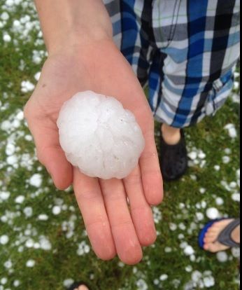
Polar Invasion Spawns Colorado Storms, Turning Lawns White With Hail (Jul 14)
While the storm that whitened lawns in parts of Colorado on Monday was the result of the polar air shoving its way south into a typically warm and moist July air mass, it wasn't a snowstorm.
Instead, it was hail that blanketed the ground in Berthoud, Colorado, on Monday. Several other Colorado communities also found themselves caked in accumulating hail as thunderstorms raked the state.
The thunderstorms formed along a front separating the unseasonably chilly polar air over the Upper Midwest from monsoonal moisture over the Southwest and the typical heat and humidity normally present over the South in mid-summer. Disturbances in the upper atmosphere and lift from winds blowing westward into the Rocky Mountains have further enhanced the thunderstorm activity over Colorado.
Berthoud is a city in Larimer and Weld counties of north-central Colorado. The two counties have had a combined 54 severe thunderstorm warnings issued by the National Weather Service so far in 2014, according to data compiled by Iowa State University. Of those 54 warnings, 53 have been issued since the beginning of May.
Source
http://www.weather.com/news/weather-severe/polar-invasion-colorado-...
Jul 15, 2014
Gerard Zwaan
From twitter
Unique! The netherlands is the warmest place in Europe pic.twitter.com/V6v8XGMbIc
source: https://twitter.com/weermanrobert/status/490503015313727488/photo/1
Jul 19, 2014
jorge namour
Bad weather, violent storms in France: Huge hail, and it's coming on Italy ... [PHOTOS]
Saturday, July 19, 2014
As widely expected, the weather in the afternoon today hath been dogged with particular violence of England and France, where even now you are experiencing severe thunderstorms. Particularly violent hailstorms in France, where the grains than 5-6cm in diameter in the inland areas of the country (see photo accompanying this article). They are the same storms that will come in the next few hours on the north of Italy, therefore utmost attention to possible extreme events tomorrow - Sunday 20 - to the north.
http://www.meteoweb.eu/2014/07/maltempo-violenti-temporali-in-franc...
https://translate.google.com/translate?sl=it&tl=en&js=y&...
----------------------------------------------------------------------
Iran will rewrite a new page in history climate: the smashed +53 ° C to Gotvand, set a new world in 2014 max
Saturday, July 19, 2014
The high temperatures reached in recent days southern Iran
As we had budgeted in recent days, the heat has really made "fierce" in various places and cities of the Middle East, where the thermometer has crossed the fateful threshold of +50 ° C in the shade, with several peaks up to +51 ° C +52 ° C reached in the south of Iran.
Right on Iranian territory were reached, in recent days, the highest temperatures recorded on the Asian continent since the beginning of 2013. Iran has managed to overcome even extreme temperatures over 50 ° C, usually between May and the first days of June, you can reach in southern Pakistan, in the region of Baluchistan. Among the higher temperatures, above all, the incredible stand +53.0 ° C Gotvand, which represent nothing less than the highest temperature reached and extreme outside of the note "Death Valley" (the famous depression in the heart of the California desert Eastern Europe), which is still the world record holder for heat, with its undefeated +53.9 ° C, the highest temperature ever reached the highest on Earth since the beginning of 2014.Ma is not over here. Because in addition to the new record hot world of 2014, with net Gotvand +53.0 ° C, always yesterday was touched upon the record of the higher minimum, with +40.6 ° C marked in Hoeyniyeh, which also touches the the average daily temperature higher than ever archived on Earth, with an average estimated at +45.5 ° C.
http://www.meteoweb.eu/2014/07/liran-riscrive-nuova-pagina-storia-c...
https://translate.google.com/translate?sl=it&tl=en&js=y&...
-----------------------------------------------------
Exceptional thermal contrasts in Kazakhstan, from 40 ° C in the south-west to +0 ° C in the north-east
Saturday, July 19, 2014,
These days, Kazakhstan, great giant of Central Asia, is a country literally split in two, in terms of weather / climate. In fact, while the western sector of Kazakhstan is under the effects of an intense heat wave of Mobile, to the east colder air that slips from central Siberia is causing a dramatic drop in temperatures, with values close to 0 ° C even. These days we find maximum temperatures up to +39 ° C +40 ° C in the south-west of Kazakhstan, while further east, in Balaskin in the north-east, this morning there was an unusually cold summer. These strong thermal contrasts should persist in the coming days, between the west and the east Asian country.
https://translate.google.com/translate?sl=it&tl=en&js=y&...
Jul 20, 2014
Howard
Rare Tornado, Violent Storms Kill 2 in France, Hundreds Evacuated (Jul 20)
The tornado hit a campsite in the town of Saint-Just-d’Ardeche, pulling down trees and destroying caravans and tents on Sunday afternoon.
A 42-year-old Frenchman died when a tree fell on him as the tornado hit. Five others were left injured although their conditions are not believed to be life-threatening.
Captain François Degrange, from the local police told AFP that trees had been brought down over a three to four kilometer radius.
“I have never seen that in my career before,” he said.
In a separate incident a woman was also killed by a falling tree at a campsite at Saint-Paulet-de-Caisson in the neighbouring Gard department.
According to Midi-Libre newspaper a baby was also injured as the storms hit and had to be rushed to hospital.
Hundreds of campers in the region have had to be evacuated.
Nine departments in eastern France remained on alert for storms on Sunday evening, while other areas of north eastern France were on alert for heavy rain and floods.
Source
http://www.thelocal.fr/20140720/storms-and-mini-tornados-leave-two-...
Jul 20, 2014
lonne rey
Emmental floods reaches historic high
http://origin.swissinfo.ch/eng/multimedia/emmental-flood-reaches-hi...
Torrential rains in the Emmental region caused the Emme river to overflow its banks on Thursday, causing massive flooding in the area. Statistically, this level of flooding takes place just once in 300 years, the environment ministry reported.
The rain began early Thursday morning, with more than 100 litres per square metre falling within hours
Jul 25, 2014
lonne rey
First Tornado in Suffolk County in Over 64 Years Rips Through Revere
http://www.nobomagazine.com/2014/07/28/first-tornado-in-suffolk-cou...
REVERE – Extreme weather rolled into the North of Boston region on Monday morning, spawning a tornado that ripped off roofs, uprooted trees, and shattered windows in the coastal community.
“It’s really a miracle that no one sustained more serious injuries,” said Revere Mayor Dan Rizzo. “This clearly was an unexpected incident that took all of us by surprise.”
“This was the first tornado on record not only in Suffolk County but in Revere,” said City Councilor and lifelong resident Ira Noveletsky. “The City and all agencies who responded did so in an extraordinary effort. We are cleaning up and we will prevail.”
Jul 30, 2014