Earth Changes and the Pole Shift
Wild Weather, the Wobble Effect
|
Weather: |
Tides and Whirlpools:
|
"We warned at the start of ZetaTalk, in 1995, that unpredictable weather extremes, switching about from drought to deluge, would occur and increase on a lineal basis up until the pole shift. Where this occurred steadily, it has only recently become undeniable. ZetaTalk, and only ZetaTalk, warned of these weather changes, at that early date. Our early warnings spoke to the issue of global heating from the core outward, hardly Global Warming, a surface or atmospheric issue, but caused by consternation in the core. Affected by the approach of Planet X, which was by then starting to zoom rapidly toward the inner solar system for its periodic passage, the core was churning, melting the permafrost and glaciers and riling up volcanoes. When the passage did not occur as expected in 2003 because Planet X had stalled in the inner solar system, we explained the increasing weather irregularities in the context of the global wobble that had ensued - weather wobbles where the Earth is suddenly forced under air masses, churning them. This evolved by 2005 into a looping jet stream, loops breaking away and turning like a tornado to affect the air masses underneath. Meanwhile, on Planet Earth, droughts had become more intractable and deluges positively frightening, temperature swings bringing snow in summer in the tropics and searing heat in Artic regions, with the violence of storms increasing in number and ferocity."
From the ZetaTalk Chat Q&A for February 4, 2012:
The wobble seems to have changed, as the temperature in Europe suddenly plunged after being like an early Spring, Alaska has its coldest temps ever while the US and much of Canada is having an extremely mild winter. India went from fatal cold spell to balmy again. Has the Earth changed position vs a vs Planet X to cause this? [and from another] Bitter cold records broken in Alaska - all time coldest record nearly broken, but Murphy's Law intervenes [Jan 30] http://wattsupwiththat.com/2012/01/30/bitter-cold-records-broken-in-alaska Jim River, AK closed in on the all time record coldest temperature of -80°F set in 1971, which is not only the Alaska all-time record, but the record for the entire United States. Unfortunately, it seems the battery died in the weather station just at the critical moment. While the continental USA has a mild winter and has set a number of high temperature records in the last week and pundits ponder whether they will be blaming the dreaded "global warming" for those temperatures, Alaska and Canada have been suffering through some of the coldest temperatures on record during the last week.

There has been no change in the wobble pattern, the wobble has merely become more severe. Nancy noted a Figure 8 format when the Earth wobble first became noticeable, in early 2005, after Planet X moved into the inner solar system at the end of 2003. The Figure 8 shifted along to the east a bit on the globe between 2005 and 2009, (the last time Nancy took its measure) as Planet X came closer to the Earth, encountering the magnetic N Pole with a violent push earlier in the day. But the pattern of the Figure 8 remained essentially the same. So what changed recently that the weather patterns became noticeably different in late January, 2012?
The N Pole is pushed away when it comes over the horizon, when the noon Sun is centered over the Pacific. This regularly puts Alaska under colder air, with less sunlight, and thus the historically low temps there this January, 2012 as the wobble has gotten stronger. But by the time the Sun is positioned over India, the N Pole has swung during the Figure 8 so the globe tilts, and this tilt is visible in the weather maps from Asia. The tilt has forced the globe under the hot air closer to the Equator, warming the land along a discernable tilt demarcation line.
The next loop of the Figure 8 swings the globe so that the N Pole moves in the other direction, putting the globe again at a tilt but this time in the other direction. This tilt is discernable in weather maps of Europe, again along a diagonal line. Depending upon air pressure and temperature differences, the weather on either side of this diagonal line may be suddenly warm or suddenly cold. The tilt and diagonal line lingers to affect much of the US and Canada, but the Figure 8 changes at this point to be an up and down motion, pulling the geographic N Pole south so the US is experiencing a warmer than expected winter under a stronger Sun. Then the cycle repeats, with the magnetic N Pole of Earth pushed violently away again as the Sun is positioned over the Pacific.
From the ZetaTalk Chat Q&A for April 6, 2013:
Would the Zetas be able to let us know what is causing the early break-up of the Arctic Ice, the ice seems to have taken on a swirling pattern at the same time, would this be wobble related? [and from another] http://www.vancouversun.com/news/national/Canada+Arctic+cracks+spectacular+event/8185609/story.html The ice in Canada’s western Arctic ripped open in a massive “fracturing event” this spring that spread like a wave across 1,000 kilometres of the Beaufort Sea. Huge leads of water – some more than 500 kilometres long and as much as 70 kilometres across – opened up from Alaska to Canada’s Arctic islands as the massive ice sheet cracked as it was pushed around by strong winds and currents. It took just seven days for the fractures to progress across the entire area from west to east. [and from another] http://earthobservatory.nasa.gov/IOTD/view.php?id=80752&src=iotdrss A high-pressure weather system was parked over the region, producing warmer temperatures and winds that flowed in a southwesterly direction. That fueled the Beaufort Gyre, a wind-driven ocean current that flows clockwise. The gyre was the key force pulling pieces of ice west past Point Barrow, the northern nub of Alaska that protrudes into the Beaufort Sea.

The Figure 8 formed by the N Pole during the daily Earth wobble has shifted somewhat to the East, due to Planet X positioned more to the right of the Earth during its approach. This was anticipated, and well described in ZetaTalk, the Earth crowding to the left in the cup to escape the approach of Planet X, so the angle between these two planets would change slightly. This shift of the Figure 8 to the East is due to the push against the Earth’s magnetic N Pole occurring sooner each day than prior. Thus instead of occurring when the Sun is high over the Pacific, over New Zealand, it is now occurring when the Sun is high over Alaska. All the wobble points have shifted eastward accordingly.
This has brought a lingering Winter to the western US, and a changed sloshing pattern to the Arctic waters. Instead of Pacific waters being pushed through the Bering Straits into the Arctic when the polar push occurs, the wobble is swinging the Arctic to the right, and then later to the left, creating a circular motion in the waters trapped in the Arctic. Since the Earth rotates counterclockwise, the motion also takes this path. This is yet another piece of evidence that the establishment is hard pressed to explain. They are attempting to ascribe this to high pressure and wind, all of which are not new to the Arctic, but this circular early breakup of ice in the Arctic is new.
Kojima
* 5 February 2014: South America – Severe Weather, Volcano [Relief Web; 5 February, 2014]
Download PDF (509.93 KB)
Argentina:
Heavy rainfall resulted in house collapses and a significant number of others severely affected, in the municipality of San Pedro, Buenos Aires province. The main highway Rosario-Buenos Aires was interrupted, and so were many other roads. In the next 48h, rain and thunderstorms may still affect most of the province. (ECHO,SMN)
Bolivia:
Heavy rainfall and consequent floods and river overflows have affected a total of 37 600 families in all nine departments of Bolivia and killed 31 people countrywide. Worst affected are the departments of Beni, Cochabamba, La Paz and Chuquisaca.
As of 4 February, evacuations were ongoing in three municipalities in Beni and two in La Paz. Rainfall will continue affecting the country for the next 72h. (ECHO, SENAMHI)
Peru:
Heavy rainfall caused river overflows, floods and landslides in southern Peru. In the department of Madre de Dios, several districts in the provinces of Tambopata, Manu and Tahuamanu have declared a State of Emergency, since 3 000 people have lost their houses to the floods. Shelters are being established, in order to continue evacuations. Heavy rainfall is forecasted to continue, which pose further risk of river overflowing. In the departments Cuzco, Puno, Apurimac and Pasco, several houses have collapsed due to landslides triggered by rain and roads have become impassable, affecting thousands of people. (ECHO, SENAMHI)
Ecuador:
Tungurahua volcano continues its eruptive process, forcing the authorities to raise the Alert level to Orange for the provinces of Tungurahua and Chimborazo, on 1 February. On 4 February, the volcano emitted ash columns which reached 3km in height. On 3 February, agricultural assistance was delivered by the Ministry of Agruculture. (National Civil Protection, Local Media)
Feb 6, 2014
KM
http://www.dailymail.co.uk/news/article-2553989/Slovenia-buried-FOU...
Slovenia buried under FOUR INCHES of black ice as freak blizzard leaves 100,000 people without power and does €66million damage
By Tom Gardner
PUBLISHED: 17:20 GMT, 7 February 2014 | UPDATED: 19:19 GMT, 7 February 2014
Swathes of Slovenia have been entombed in a four-inch thick layer of ice after Eastern Europe was hit by a freak blizzard.
Pylons buckled under the extraordinary weather conditions, leaving more than 35,000 households - up to 100,000 people - without power.
The damage is expected to reach €66million. But authorities are not yet able to reach more remote parts of the country which have been cut off as the transport network failed.
Frozen: A traffic island and road signs are buried beneath four inches of ice after an historic blizzard hit eastern Europe
Blackout: Towns and villages across Slovenia suffered power cuts as the electric grid began to collapse in the face of the historic blizzard
Rain brought in on a warm weather front collided with freezing air hanging over much of the country, causing the water droplets to turn to rock hard ice the moment they landed.
Anything which come into contact with the rain was soon covered in a thick layer of impenetrable ice.
Extreme weather chaser Marko Korosec took photographs of damage wreaked by the terrifying natural phenomenon.
Mr Korosec, 32, said cars, buildings, bridges, roads, trees, road signs and powerlines disappeared in the storm's icy aftermath.
Feb 8, 2014
sourabh kale
http://www.climate.gov/news-features/event-tracker/wobbly-polar-vor...
Wobbly polar vortex triggers extreme cold air outbreak
Maps show the 500-millibar geopotential height (the altitude where the air pressure is 500 millibars) on January 5, 2014 (left), and in mid-November 2013 (right). The cold air of the polar vortex is purple. Maps by NOAA Climate.gov, based on NCEP Reanalysis data from NOAA ESRL Physical Sciences Division. large images January 5 | mid-November 2013
‘Polar vortex’ is the new buzzword of 2014 for the millions of Americans learning about its role in producing record cold temperatures across the country. Meteorologists have known for years that the pattern of the polar vortex determines how much cold air escapes from the Arctic and makes its way to the U.S. during the winter. Now climate scientists want to know if a warmer Arctic is influencing its behavior.
The polar vortex is a high altitude low-pressure system that hovers over the Arctic in winter. When the polar vortex is strong, it acts like a spinning bowl balanced on the top of the North Pole. The image on the right shows a strong phase of the polar vortex in mid-November 2013. Dark purple depicts the most frigid air tightly contained in an oval-shaped formation inside the invisible bowl. The light purple line forming the outermost boundary of the cold Arctic air is the jet stream in its normal west-to-east pattern.
In early January, the polar vortex weakened and broke down*, allowing fragments of cold air to slosh out of the bowl into mid-latitudes. The image on the left shows the weakened vortex formation on January 5, 2014. The high pressure building up in the Arctic slowed down the jet stream, which caused it to buckle into deep folds and flow farther south than usual, introducing cold Arctic air into the central and eastern U.S.
In recent years, climate scientists have noticed that the jet stream has taken on a more wavy shape instead of the more typical oval around the North Pole, leading to outbreaks of colder weather down in the mid-latitudes and milder temperatures in the Arctic, a so-called “warm Arctic-cold continents” pattern. Whether this is normal randomness or related to the significant climate changes occurring in the Arctic is not entirely clear, especially when considering individual events. But less sea ice and snow cover in the Arctic and relatively warmer Arctic air temperatures at the end of autumn suggest a more wavy jet stream pattern and more variability between the straight and wavy pattern.
Understanding the connections between the Arctic warming trend and more severe weather in the mid-latitudes remains an active area of research. But even as Earth’s average temperature rises, natural patterns of climate variability are expected to still operate in a warmer world. There have been many other cases of natural climate oscillations influencing our winter weather in recent years. The unusually cold winter of 2009-2010 proved that record-breaking snowstorms can still coexist with global warming, as did the frigid start to 2011, which resulted in another wintry winter for the eastern United States.
*CORRECTION: This sentence originally attributed the breakdown of the polar vortex to a sudden stratospheric warming event, which did not actually develop.
Map by NOAA Climate.gov, based on NCEP/NCAR Reanalysis data. Reviewed by James Overland, NOAA PMEL.
Editor's note: Please pardon the erroneous event locator icon on the map at upper right. Due to technical difficulties, the dot is showing up off West Africa. Please know that the Climate.gov communications team does, in fact, know where the North Pole is, and bear with us as our web techs troubleshoot the problem.
Related Links NOAA Pacific Marine Environmental Laboratory (2014, January 6) What's going on with the Polar Vortex?
Washington Post (2014, December 31) Sudden stratospheric warming: could it lead to a very cold January ...
Climate Central (2013, January 21) Stratospheric Phenomenon Is Bringing Frigid Cold to U.S.
NOAA (2011, February 28) Warm Arctic, Cold Continents
Reference Francis, J. A. and S. J. Vavrus, 2012: Evidence Linking Arctic Amplification to Extreme Weather in Mid-Lat..., Geophys. Res. Lett., Vol. 39, L06801, doi:10.1029/2012GL051000
Overland, J.E., K.R. Wood, and M. Wang (2011): Warm Arctic–cold continents: Impacts of the newly open Arctic Sea. Polar Res., 30, 15787, doi: 10.3402/polar.v30i0.15787.
Feb 14, 2014
sourabh kale
Arctic now the warmest it has been in 44,000 years, research finds
by ClickGreen staff. Published Tue 21 Jan 2014 15:51, Last updated: 2014-01-21
When the temperature rises on Baffin Island, in the Canadian high Arctic, ancient Polytrichum mosses, trapped beneath the ice for thousands of years, are exposed. Using radiocarbon dating, new research has calculated the age of relic moss samples that have been exposed by modern Arctic warming.
Since the moss samples would have been destroyed by erosion had they been previously exposed, the authors suggest that the temperatures in the Arctic now must be warmer than during any sustained period since the mosses were originally buried.
The researchers collected 365 samples of recently exposed biological material from 110 different locations, cutting a 1000 kilometer long transect across Baffin Island, with samples representing a range of altitudes.
From their samples the authors obtained 145 viable measurements through radiocarbon dating. They found that most of their samples date from the past 5000 years, when a period of strong cooling overtook the Arctic. However, the authors also found even older samples which were buried from 24,000 to 44,000 years ago.
The records suggest that in general, the eastern Canadian Arctic is warmer now than in any century in the past 5000 years, and in some places, modern temperatures are unprecedented in at least the past 44,000 years. The observations, the authors suggest, show that modern Arctic warming far exceeds the bounds of historical natural variability.
“The great time these plants have been entombed in ice, and their current exposure, is the first direct evidence that present summer warmth in the Eastern Canadian Arctic now exceeds the peak warmth there in the Early Holocene era”, said Gifford Miller, from the University of Colorado.
“Our findings add additional evidence to the growing consensus that anthropogenic emissions of greenhouse gases have now resulted in unprecedented recent summer warmth that is well outside the range of that attributable to natural climate variability.”
http://www.clickgreen.org.uk/research/data/124103-arctic-now-the-wa...
Feb 14, 2014
sourabh kale
Record warmth, confused plants: An Alaska January to remember
January 28, 2014
Warm weather blanketing Alaska for days now has shattered records, turned plants green and changed the way some people live.
The temperature hit 62 degrees at Port Alsworth, on Lake Clark, on Monday, tying the highest January temperature ever recorded in the state, the National Weather Service reported.
Nome peaked at 51 degrees, topping the city's warmest January with a temperature typical of early June, forecasters said.
In Anchorage, snow continued melting Tuesday in the latest of 15 consecutive days with temperatures at 32 degrees or above. As of Monday, it was the city's fourth warmest January ever recorded.
"It's spectacular," said Sam Albanese, warning coordination meteorologist with the weather service.
While Alaska is prone to warm spells occasionally breaking up winter freeze, the string of unseasonably warm days rarely last for this long, he said.
In 1949, there were 17 days of temperatures at freezing or above and 16 days in 1985, said the weather service.
Albanese expects temperatures in Anchorage to cool down in the next few days, but still hover above normal. Temperatures will dip below freezing at night, he said.
Rick Thoman, climate program manager for the weather service, said Tuesday that he didn't see much sign of precipitation in mainland Alaska for the next two weeks.
"As far as places that have lost most of their snowpack, there's no sign that we would get into a pattern that would rebuild that to a significant extent," he said.
Warm temperatures and a shallow snowpack closed the Alyeska Ski Resort in Girdwood indefinitely.
Organizers have cancelled or rerouted sled dog races. The Nordic Ski Association of Anchorage may have to turn Sunday's Ski for Women event into a run or walk. A decision will be made on Saturday. Christine Cikan, 50, slid on the slick trails around Westchester Lagoon with her dog Tuesday afternoon.
The meltdown has forced her to routinely bury her perennials in snow to keep the roots alive. She chipped away the ice on half of her Russian Jack driveway to ease mobility.
"I don't usually have my ice grippers on every day, but I haven't bothered taken them off this past month," she said.
Steve Brown, a district agriculture agent for the University of Alaska Fairbanks Cooperative Extension Service, lost about a third of his perennial garden last year when a thick freeze piggy-backed a defrost, he said.
He said he's heard from Alaska peony farmers concerned another year of thaw-freeze could rip apart their crop.
"Everyone with a perennial garden is worried sick as well," Brown said. "If it gets super cold before we get some snow there's going to be a lot of stuff lost."
Brown recommended people use straw, shredded paper, snow or hay to insulate gardens from overnight drops in temperature.
"The paper doesn't decompose very fast, but you could just rake it up in the spring," he said.
Area biologists in Anchorage and Fairbanks said warm temperatures haven't interrupted one species too much -- the bears.
A bear may wake up from hibernation briefly if water enters its den or if stirred by seismic activity or close, loud noise, said Jessy Coltrane, Anchorage-area wildlife biologist with the Alaska Department of Fish and Game.
Coltrane has heard one fourth-hand report of a bear spotting in Anchorage this winter. In Fairbanks, a pilot spotted one bear about 30 miles from the city.
"It's not like on Monday when it hit 50 degrees every bear jumped out of its den and started to run," Coltrane said.
Still, she recommended people carry bear spray when going into bear country.
Feb 17, 2014
sourabh kale
The bears in russia and california know something is wrong! When will the people of the world ?
Warm winter keeps Russian bears from sleeping
For almost two months now, Russia has been experiencing unseasonably warm weather. This quirk of nature has come as an unpleasant surprise to animals living in the wild: bears and hedgehogs have not been hibernating.
Rabbits turned white back in the autumn, meaning that for almost two months, they have been easy targets for hunters and predators. Honeysuckle is flowering for the third time this year.
Meanwhile, Russian biologists have been trying to make sense of this freak of nature.
“For hunters it’s tough at the moment, but for wild animals life is good,” said Yevgeniy Yeskov, a professor at the Russian State Agrarian University. “Until now, people carrying weapons would lie in wait as their prey looked for food, but now there’s no need for animals to go anywhere near humans, because there’s plenty of food in the forest.”
This winter hedgehogs have not been hibernating. Source: Alamy / Legion Media
The ungulates have currently got the best deal in the forest – they’re still nibbling on green grass. But rabbits have turned white and are now easy prey.
“Until the first snows arrived, hares were easy prey for hunters, but we don’t have any data confirming that lots of them have died,” Yeskov said. “Animals are, after all, like humans: the less energy they have to expend to keep themselves warm, the bolder and cheerier they are.”
Russian bears searching remote villages for food
Birds are also affected. “It’s not just the ducks that live in towns, but also the ones that live in the wild, that have chosen not to take flight. After all, for wildfowl, the signal for them to head for warmer climes is when rivers and lakes freeze over. But if there’s no ice, there’s no reason to fly away,” Yeskov said.
Bears will hibernate as soon as there’s snowfall. Hibernation is their number two priority, while food is number one. If there’s plenty of food, there’s no reason for bears to sleep.
“Some people I know say they’ve seen bears walking through the forest in December and in January. But as soon as the first real snow arrives, they’ll definitely settle down. It’s the same for hedgehogs. How long they hibernate depends on how much food they’ve had. If a hedgehog hasn’t had enough to eat and wakes up early, it will definitely freeze. This year, there are certainly no fears of that happening in European Russia,” Yeskov said.
As for the botanists, they’re not observing anything preternatural. They believe this is not the first time there have been such warm winters. On the other hand, it’s interesting for specialists like them, accustomed to all sorts of surprises, to see plants flowering for the third time in the space of a year.
“This year honeysuckle has flowered three times,” said Andrey Tsitsilin, who runs the botanical garden at VILAR, the All-Russian Medicinal and Scented Plants Research Institute.
“Mixed yellow-white flowers look rather elegant against a backdrop of fresh snow. Honeysuckle blossomed first in May, as usual, then it flowered for a second time in late October, and now it’s showing off its delights for the third time. That’s never happened before.”
Apparently, honeysuckle does not freeze and die if the frost comes while it’s blossoming.
“It might be that its berries will be smaller than usual. But overall, a lot will depend on the cold weather, which we’re expecting to arrive after 19 January. If the temperature plummets to minus 20 or 30, there might not be any fruit. We’re seeing lilacs with swollen buds, but they might also disappear. It’s a good thing that we’re not seeing this with stone fruits, such as cherries and plums. They’re very sensitive to cold weather,” Tsitsilin said.
First published in Russian in Moskovskiy Komsomolets.
http://rbth.ru/society/2014/01/15/warm_winter_keeps_russian_bears_f...
Weirdly warm, dry winters spur black bears to halt hibernating, start eating
(CNN) -- They barely slept.
That's the case for an unusual number of black bears in western Nevada, where an abnormally warm and dry winter has spurred them to halt their hibernation and head out for food.
"They may be sleeping under a deck or under a house in a crawlspace, and they will emerge when it is a garbage day and raid some garbage cans and then go back to a sleep for a while," explains Chris Healy, a spokesman for the Nevada Department of Wildlife.
Mother Nature can take credit for these bears' abbreviated slumber. Whereas parts of the Midwest and Northeast are now buried in snow and shivering in cold, that's not the case in many communities around Lake Tahoe and elsewhere.
The National Weather Service's forecast for Incline Village, Nevada, for instance, calls for high temperatures heading to or well past 50 degrees for the next week at least, with nary of snow flurry in sight.
What's with this weather? Hot is cold and cold is hot
It's not just Nevada: Nearby Northern California is also seeing an abnormal number of black bears, with CNN affiliate KXTV showing images taken from Yosemite National Park and Lake Tahoe's Heavenly Ski Resort.
Healy said "a disastrous winter" -- adding "we need the snow" -- and relatively mild temperatures have thrown off some black bears that live in more settled areas, where they can readily access human garbage.
"We documented this and, in the past 15 years, it occurs sporadically," the spokesman said. "A lot of it is dictated by the weather conditions."
Even in a typical winter, black bears don't hibernate completely as some might think, usually taking a few weeks for their metabolism and body temperature to wind down. They will occasionally wake up, roam a bit, but won't eat, drink, urinate or defecate, according to SierraWild.gov, a cooperative website of the federal U.S. Forest Service, National Park Service and Bureau of Land Management that covers the Sierra Nevada mountain range, including Lake Tahoe).
Bears in this range typically "den" between mid-December into March or the beginning of April, SierraWild.gov notes. This is less than the seven and a half months for some black bears that live in colder climes, but still well beyond what's being seen in parts of Nevada.
In the past, "lighter winters" have been correlated to "bigger bears that live among humans in Incline Village in the Lake Tahoe basin," notes Healy.
But it's not like every black bear is cutting short hibernation and heading out on the town.
Healy notes, "Bears in the backcountry -- truly wild bears -- don't partake in this."
"They eat nuts and berries and things that are not found in nature right now," he said, in contrast to the relatively ever-present trash rummaged through by other bears. "So they wouldn't wake up to eat, they wouldn't find anything."
It has also been "unusually warm" this winter in much of Alaska.
But state wildlife official Riley Woodford said that bears coming out of hibernation early hasn't been an issue there yet.
That's because the winter started off, around November, normally. Even though it's warmed up, the bears climbed up to 1,000 feet to den in snowy and icy spots that's cold enough to keep them in, he says.
Still, the state Department of Fish and Game admits that, hibernating or not, the weather has been weird. It's not even forecast to go below freezing -- even at night -- in Juneau for at least a week. And last week, it was even raining 3,000 feet above sea level in one ski resort around the Alaskan capital, Woodford recalls.
Historic California drought forces rancher to thin herd of horses
http://edition.cnn.com/2014/01/22/us/bears-stop-hibernating/
Sierra's bears wide-awake during warm winter
Sierra residents startled as animals forage for food
January 20, 2014
The black bears of the high Sierra are normally curled up in caves in January, enjoying long winter naps.
But with winter conditions hardly wintry this year, some bears are finding little reason to hibernate and are instead traipsing around like it's the middle of August.
Mountain residents and visitors have been startled by unexpected encounters with the giants, and wildlife managers from Lake Tahoe to Yosemite National Park are cautioning folks about bear activity. Increased interaction between man and beast can lead to problems.
This month, skiers at Heavenly Mountain Resort in South Lake Tahoe were stopped in their tracks by a bear scampering across a ski slope, a scene that was caught on video and spread across the Internet. Fortunately, the bear scurried off without incident.
On the north side of the lake, a 260-pound male bear broke into several cars last month and at least one home. He was deemed a threat to public safety, prompting wildlife managers to put the animal down. An Incline Village woman was given Nevada's first written warning for feeding the bear, authorities said.
The effects of the mild winter go further than bears, biologists say. All kinds of critters act differently during drought times, particularly if the dry weather extends through spring and causes food and water shortages, which can push animals beyond their normal range in search of sustenance.
Continuing to forage
For now, though, it's the bears drawing attention.
"In this weather, you're going to see more of them," said Chris Healy with the Nevada Department of Wildlife. "They're totally content to hibernate, but if the food's available, they'll get up and eat."
Black bears are not what many biologists call "true" hibernators. Unlike other animals, such as marmots, chipmunks and ground squirrels - whose dwindling body temperature forces them to retreat into a warm winter sleep - the larger, well-insulated bears hunker down only when food is hard to come by, biologists say.
In the Sierra, that means bears generally slumber between December and March. But with little snow bogging them down this year, many are continuing to forage. And some are falling back on their bad summer habit of seeking out the easy pickings of human trash.
While a small percentage of bears in the Lake Tahoe area have switched permanently to hibernation-free winters and scavenge residential neighborhoods year-round, counts of scavenging bears rise during dry years, according to wildlife managers.
"If we got 5 or 6 feet of snow up at the lake like we're all praying for, we'd be ecstatic because the bears would stay hunkered down," Healy said, "plus we'd have water for next summer."
Farther south, officials at Sequoia and Kings Canyon national parks also report more bear activity. Yosemite officials say they're not noticing the volume of bears they see in the summer - when the animals famously pillage cars and campgrounds - but there have been sightings, which are relatively uncommon this time of year.
Food chain may be at risk
Wildlife managers, meanwhile, are enforcing regulations more typical of July and August: Don't feed the bears, don't leave food in your vehicle, and secure your trash. The harm in breaking the rules, they say, is that bears become accustomed to humans, which increases the chance of a perilous exchange between an animal and a person.
This winter ranks among California's driest, and the parched spell follows two low-precipitation winters. As of last week, snowpack in the Sierra measured just 17 percent of normal.
The mild conditions mean more bears are awake than usual, and wildlife managers worry the problem is just beginning. Should the dry weather continue, it could upset the Sierra food chain - for example, limiting the amount of berries or insects for bears to feed on - and force the hungry animals into town.
"A drought basically dries up the natural food availability and dries up the water sources, and you get them not only wandering farther, but often coming to urban areas to fulfill their daily needs," explained Jason Holley, wildlife biologist supervisor for the California Department of Fish and Wildlife. "We've seen upticks in drought years. We could be looking at that in the spring."
The same can be said of other critters: deer, coyotes, bobcats.
"A drought will affect basically all wildlife," Holley said. "They'll either walk or fly far enough to find what they need."
http://www.sfgate.com/science/article/Sierra-s-bears-wide-awake-dur...
Feb 18, 2014
jorge namour
In Rome, far away from the center ever so hot in 1782: here are the official data of the Collegio Romano
Tuesday, February 18, 2014
In 232 years, that 'since in 1782 the Meteorological Observatory of the Collegio Romano, the more' old city ', the temperatures are recorded in the capital, he had never encountered such a hot in the second week of February in Rome. "It 'record today in Rome where they were recorded 20.6 ° C, the temperature more' hot 232 years in the second week of February. - Says the president of the Association Bernacca and for years head of the Observatory Franca Mangianti -. The previous record was in 1892 when in Rome were recorded 19.9 degrees. " Even the minimum temperatures are above the average of 5/6 degrees. High rate of moisture 'in Rome this morning at 7 am was 88% at 10 and 75%.
http://translate.google.com/translate?sl=it&tl=en&js=n&...
http://www.meteoweb.eu/2014/02/a-roma-centro-mai-cosi-caldo-dal-lon...
Feb 19, 2014
Howard
Bizarre "River of Sky" Clouds Over Atlanta (Feb 25)
Meteorologist Chesley McNeil said the clouds are very rare in the southeast, but more common in the midwest.
He also says there's debate over what causes the phenomenon.
Scientists agree it's a meeting of two fronts, but are split on whether it's caused by a cold/warm front or a dry/moist front.
The Royal Meteorological Society is documenting their appearance to see if they deserve a separate cloud classification.
If that happens, it would be the first new cloud classification since 1951.
Sources
http://www.13wmaz.com/story/weather/2014/02/25/rare-river-of-the-sk...
http://www.accuweather.com/en/weather-news/photos-bizarre-beautiful...
Feb 25, 2014
K Tonkin
What a difference one week makes (seasons are blending!):
All temps are in degrees Fahrenheit - be sure to note the last column in the table below
http://www.crh.noaa.gov/news/display_cmsstory.php?wfo=unr&story...
Spectacular Warmth - Some Records Broken
Spectacular warmth was felt across northeast Wyoming and western South Dakota today (March 9, 2014). Records were set in Rapid City, Fort Meade, and near Interior.
A RECORD HIGH TEMPERATURE OF 73 DEGREES WAS SET AT RAPID CITY AIRPORT SD TODAY. THIS TIES THE OLD RECORD OF 73 SET IN 2012.
A RECORD HIGH TEMPERATURE OF 72 DEGREES WAS SET AT EAST RAPID CITY SD TODAY. THIS BREAKS THE OLD RECORD OF 71 SET IN 2012.
A RECORD HIGH TEMPERATURE OF 71 DEGREES WAS SET AT FORT MEADE SD TODAY. THIS BREAKS THE OLD RECORD OF 70 SET IN 2012.
A RECORD HIGH TEMPERATURE OF 73 DEGREES WAS SET AT INTERIOR 3 NE SD TODAY. THIS BREAKS THE OLD RECORD OF 71 SET IN 2012.
Temperatures today were stunningly warmer than temperatures one week ago. Thermometers read 67 to 97 degrees warmer than lows March 2, 2014!
Mar 10, 2014
K Tonkin
Lake Michigan Ice Cover Reaches Record Coverage!
http://www.crh.noaa.gov/news/display_cmsstory.php?wfo=mkx&story...
This last stretch of cold weather during late February into the first week of March caused ice concentration on Lake Michigan to rapidly increase. The Great Lakes Environmental Research Laboratory (GLERL) in Ann Arbor Michigan measures the ice concentration on the Great Lakes daily. On March 8th, the ice concentration on Lake Michigan was measured at 93.29%. This sets a new record ice cover on Lake Michigan. The previous record was 93.1% set in 1977. The period of record dates back to 1973.
The below graph shows the rapid increase in ice concentration since late February.
The below graphic prepared by GLERL estimates the ice thickness in centimeters on Lake Michigan. Most of the ice to the east of southeast Wisconsin ranged from 18 to 36 cm thick or about 7 to 14 inches.
The total ice cover on the Great Lakes from March 8th was estimated to be over 90% as depicted by the below graphic from GLERL. The record ice cover for the Great Lakes is 94.7% set in 1979. The lowest on record is 9.5% in 2002.
Mar 12, 2014
Howard
Massive Sand Storms Barrel Across Southwest U.S. (Mar 11)
As a cold front blew across parts of the High Plains on Tuesday, winds kicked up a huge and intense dust storm.
With winds gusting to nearly 60 miles per hour, visibility in southwestern Kansas was reduced to zero, according to the Cooperative Institute for Meteorological Satellite Studies. CIMSS also describes a pilot report of severe turbulence at 45,000 feet in the region, possibly the result of the passing cold front.
On the ground, a towering wall of dust known as a haboob rushed across a vast swath of the High Plains, enveloping towns and cities in a brown pall.
Source
http://blogs.discovermagazine.com/imageo/2014/03/13/high-plains-hab...
Mar 15, 2014
Andrey Eroshin
14.03.14. Freak of nature: Hail storm dumps 3ft of ice on East African nation of Eritrea
http://www.express.co.uk/news/weird/464881/Freak-of-nature-Hail-sto...
Mar 21, 2014
lonne rey
Coldest December-March Period in Chicago History
THE IMPRESSIVE COLD THIS PAST WINTER CONTINUED DURING
MARCH...WITH A MONTHLY AVERAGE TEMPERATURE OF ONLY 31.7 DEGREES
FOR THE MONTH. THIS RANKS AS THE 19TH COLDEST MARCH ON RECORD IN
CHICAGO. HOWEVER...OF EVEN MORE INTEREST IS THE FACT THAT WITH THE
ABNORMALLY COLD MARCH ACROSS THE AREA...THIS MADE THE AVERAGE
TEMPERATURE FOR THE DECEMBER THROUGH MARCH PERIOD IN CHICAGO 22.0
DEGREES...WHICH IS THE COLDEST SUCH PERIOD ON RECORD FOR CHICAGO
DATING BACK TO 1872!
ROCKFORD:
THE DECEMBER THROUGH MARCH AVERAGE
TEMPERATURE FOR ROCKFORD WAS 18.4 DEGREES. THIS RANKS AS THE 2ND
COLDEST SUCH PERIOD ON RECORD IN ROCKFORD DATING BACK TO 1906!
source
Apr 2, 2014
Yvonne Lawson
April snow in Moscow: weather continues to surprise
Photo: RIA Novosti
The weather does not cease to surprise: the European part of Russia is still taking actions to recover from the consequences of an unprecedented April snowfall; the Far East began fighting against forest fires; and Siberia is preparing for the opening of its great rivers. What weather surprises are in store for us this spring? Meteorologists told the Voice of Russia about anomalies and forecasts.
An abnormally warm February and March in the European part of Russia was replaced by April snowstorms. The heaviest snowfall in the past 130 years, which occurred in Moscow on the first day of April, turned the already spring town into a Blizzard Kingdom in just a few hours. Internet users immediately called this unusual phenomenon the main April Fool’s joke.
The unusually warm weather has set in Siberia. The air warmed up to +22 degrees. The abnormal April temperature has already caused forest fires. Dozens of hectares of taiga forest in the South of Siberia and the Far East are already enveloped in fire, chief of the Roshydromet Situation Centre, Yuri Varakin told the Voice of Russia.
"As for forest fires, the season has already started almost a month earlier, if compared to the last year and the year before last. This especially concerns the Far East and Primorsky Krai. And an immediate forecast for April says that we have increased fire hazard in the Trans-Baikal and Baikal regions, because the abnormally warm weather has set there now, and the snow melts quickly."
The early spring has also caused early floating of ice on Russian rivers. According to meteorologists, the situation is quite favourable: the winter was dry, and floods should not be expected. The majority of rivers in the European territory of Russia are at the floodplain level. All indicators suggest that there is no threat of flooding of settlements, leading specialist of the Phobos weather center, Elena Volosyuk says.
"In general, heavy rains are not expected this spring. It is obvious that in the European part of the country, floodings will be lower than in previous years, and than last year, when snowfalls were observed until the end of April and a number of regions of the European part of Russia led the pack in terms of snow storage. This year, the situation is quite different. But in Siberia, floodings, I think, will be at the level typical for this region. Opening of rivers has already begun. Ice blasting aimed at improving the ice cover situation is in progress on some rivers. So, in terms of flood, there should be no incidents."
Experts are closely monitoring the flood situation in the Far East, which suffered from the worst flood in the last 100 years last summer. Opening of ice on the Amur has already started, and it is almost a week ahead of schedule. The water level is expected to be up to the normal level. However, experts encourage local authorities to be ready for any developments of emergency situations, because the weather has repeatedly proven its unpredictability.
Read more: http://voiceofrussia.com/2014_04_05/April-snow-in-Moscow-weather-co...
Apr 6, 2014
Howard
Bizarre Cloud Engulfs Spanish Coastline (Apr 9)
A mysterious dense cloud has appeared over the entire coastline of Alicante in Spain.
The Hotel Castilla Alicante confirmed that locals have no idea what has caused the cloud saying, "dense cloud took over the entire coastline of the city of Alicante, causing some confusion among residents and tourists".
Source
http://www.mirror.co.uk/news/weird-news/alicante-apocalyptic-cloud-...
http://www.dailymail.co.uk/travel/article-2600562/Video-showing-hug...
Apr 11, 2014
Kojima
Two articles about the strong wind
1) Tehuano Winds [Earth Observatory; 8 April, 2014]
Cool air often follows storm systems passing through North America in the winter and early spring. In some cases, the cool air surges as far south as Mexico, where it encounters the Sierra Madre Oriental Mountains, a long chain oriented roughly parallel to Mexico’s Atlantic coast. The mountains behave like a wall, funneling winds to the south until they reach Chivela Pass, a gap in the range on the Isthmus of Tehuantepec.
At the gap, pressure differences between cool, dry air from the north and warm, moist air from the south cause winds to rush toward the Pacific Ocean. Northerlies that last for more than a day are known as Tehuano winds. Such winds can be extremely strong, reaching gale or even hurricane force on the Beaufort wind scale.
The Moderate Resolution Imaging Spectroradiometer (MODIS) on the Aqua satellite captured this image on April 8, 2014, when Tehuano winds carried dust over the Gulf of Tehuantepec. A thin arc cloud marked the leading edge of this pulse of wind.
Read this blog post from the Cooperative Institute for Meteorological Satellite Studies (CMISS) to learn more about the event and to see a sequence of images showing the wind front fanning outward over time.
-- [Tehuano: http://glossary.ametsoc.org/wiki/Tehuano]--
A Spanish term frequently used to denote a burst of strong offshore (southward) wind, lasting a day or more, that blows from the Gulf of Mexico across the Gulf of Tehuantepec.
Tehuano events are associated with winter surges of cold air that spread southward from the United States across the Gulf of Mexico behind strong weather fronts. Tehuanos produce much local cooling of the gulf waters and frequently cause anticyclonic warm-core ocean eddies to form and propagate west-southwestward near 12°–14°N.
2) Wildfire Burns Valparaiso, Chile [Earth Observatory; 13 April, 2014]
High winds propelled a wildfire through parts of Valparaiso, Chile, on April 13, 2014. It quickly became the largest fire in the history of this port city. The fire started in a forested area on April 12 and eventually reached wooden homes built on steep hills around the city. According to news reports, at least 12 people died, 2,000 homes were destroyed, and about 10,000 people evacuated as the fire moved through a section of the historic city.
The Moderate Resolution Imaging Spectroradiometer (MODIS) on NASA’s Terra satellite acquired this image of the fire at 11:10 am local time (14:10 UTC) on April 13. Fire detections are outlined in red in the forest south of the city, which is pale gray. A long plume of smoke stretches northwest over the Pacific Ocean, a clear indication that winds were strong and blowing the flames toward the city.
Valparaiso is the third largest city in Chile, with a population of more than 280,000 people. It was established in 1536 and developed into an important international seaport in the 19th century. The city is a UNESCO World Heritage site.
-- largest fire in the history of this port city --
http://www.mercuriovalpo.cl/impresa/2014/04/14/full/2/
-- NPR News (2014, April 14) For second night, Valparaiso fire spreads misery in Chile --
Apr 16, 2014
Kojima
China’s Great Wall of Dust [Earth Observatory: 23 April, 2014]
A wall of dust was barreling across northern China on April 23, 2014, when the Moderate Resolution Imaging Spectroradiometer (MODIS) acquired these images from NASA’s Aqua and Terra satellites. The top image was taken at 12:35 p.m. local time, and the lower image is from 2:20 p.m. Turn on the image comparison tool to see how far the dust advanced in the two hours between images.
Dust storms are common in the deserts of northern China, but they peak during the spring when large storms and weather fronts move in from Siberia. In this case, a very large front appears to be pushing east across Asia, kicking up dust ahead of it. On the ground, the dust brought visibility down to less than 50 meters (160 feet), veiling parts of northwest China in yellow haze.
The winds and resulting dust are widespread, since a dense airborne dust plume is visible under the clouds throughout the scene. The large storm also extended to the Taklimakan Desert (immediately southwest of the area shown here) on April 23 and April 24.
See also;
"Day or night? Massive sandstorm plunges China into red mist" of lonne's comment in Red Dust effects
Apr 25, 2014
Kojima
Flash floods kill more than 100 in north Afghanistan [Relief Web: 25 April, 2014]
Afghanistan Flash Floods Situation Report No. 1 as of 2300h (local time) on 25 April 2014
Download PDF (914.26 KB)
Situation Overview
Heavy rainfall, which started on 24 April, has sparked flash floods in 23 districts, across six provinces, of the Northern Region of Afghanistan. Provincial authorities report that 123 people have been killed and more are still missing.
As assessments are underway to determine the full extent of the damage caused, as well as the humanitarian needs of the affected population, it is still too early to get a full picture of the scale of the flooding. Initial reports indicate that Jawzjan province is the worst affected in the region, where 80 people have reportedly been killed and some 6,000 people have been displaced. The provinces of Faryab, Sar-e-Pul, Balkh, Samangan and Takhar have also been affected to a lesser degree.
The Afghan Government’s Provincial Disaster Management Committees (PDMC) are leading the coordination of the response within their affected provinces, with support from humanitarian agencies. Limited access to some of the more heavily affected areas remains a key challenge.
Priority needs at present include clean drinking water, medical supplies, food, non-food items and shelter.
Apr 26, 2014
lonne rey
Just days before Easter, in Romania it snowed like it was Christmas. Snow cover 10 cm in Predeal
Just days before Easter , on April 14, it snowed like at Christmas. – road workers were out working just like in a regular month of winter !
Romania was under code yellow alert for snow and rain in 12 districts in the country !
Everyone hoped the snow would pass quickly, but on Friday it began snowing again, dumping 10 cm of snow on Predeal .
Tourist : “I got winter in the mountains, we came to leave for the summer so I am not prepared for winter, I had to change the tires.
Tourist: "I've got two days of rain and sunny spring and summer and then two days yesterday and today two authentic winter days.
Worried for trees already in bloom and cultures that have sprung up in the garden
In Step Tihuta , which links Transylvania and Moldavia , snow removal machinery worked almost as hard as in full winter . Snow measured 10 inches , and the wind blew hard. Temperatures dropped to 0 degrees on Friday, and people made fires in their stoves . I am worried for the animals, but also for trees already in bloom and cultures that have sprung up in the garden.
The landscape looked like the middle of December.
source
http://translate.google.com/translate?hl=en&sl=auto&tl=en&a...
Apr 26, 2014
lonne rey
Winter comes again suddenly for Russia’s Urals
Russia’s Urals region has been hit with freak winter weather, with severe snowstorms causing massive traffic jams, flight delays, power blackouts and school closures.
Just when everybody in the cities of Ekaterinburg and Chelyabinsk thought they had waved winter good-bye and was anticipating greener spring weather, blizzards dragging the region back to winter.
Winter struck the region hard, with precipitation twice the monthly average coming as a shock to already burgeoning grass and trees.
Urals meteorologists have said the last time the region was struck by a snowfall of such severity in springtime was 123 years ago. They’ve found an April 26, 1891 issue of “Ekaterinburg Week” magazine that reported how the region witnessed “even more snow fallen than throughout the whole winter”.
source
Apr 27, 2014
Sevan Makaracı
Heatwave higher than usual for this time of year making life miserable accross Bangladesh
A heatwave that has been blazing across Bangladesh, making life miserable all around, will continue at least for two more days, the Met office says.
On Sunday, the mercury shot to 40 degrees Celsius in Rangamati, the highest temperature of the season - six notches higher than the normal reading of 34 degrees for this time of the year.
Capital Dhaka recorded a temperature of 38.5 degrees in the day.
The weather office declares heatwave conditions when the maximum temperature rises five degrees above normal to either touch or cross 40.
Senior Met officer Sanaul Haq Mandal said the high levels of humidity made the heat unbearable. On Sunday, Dhaka recorded 77 percent humidity. .....
Source
Apr 27, 2014
jorge namour
U.S., record rainfall in New York ever so much since 1882 [PHOTOS and VIDEO]
Friday, May 2, 2014,
New York City has set a new record weather: April 30th marked the record rain fall after the floods of 23 September 1882. Wednesday you are in fact recorded 126.2 mm of rain in Central Park (September 23, 1882 were recorded 210.3 mm, according to data from the National Weather Service), while the total figure reported in April 2014 to 199.3 mm.
The April 30 millimeters fell were more numerous than those who fell during Hurricane Irene or Sandy.
http://www.meteoweb.eu/2014/05/usa-pioggia-record-a-new-york-mai-co...
http://translate.google.com/translate?hl=en&sl=auto&tl=en&a...
http://www.youtube.com/watch?v=gslxuatM6H4
May 2, 2014
KM
http://english.ahram.org.eg/NewsContent/1/64/100801/Egypt/Politics-...
A severe sandstorm in Aswan in southern Egypt led to a boat accident and damage to a local museum on Wednesday.
A touristic Nile boat sank amid the unusually severe storm, leaving one South African passenger missing. Six other tourists, including one other South African, three Australians, and one Pole, as well as three Egyptians, were rescued from the boat
The Crocodile Museum in the southern city of Kom Ombo also suffered damage when its roof collapsed after the fierce sandstorm hit the governorate.
The Crocodile Museum, inaugurated in 2012, exhibits a collection of mummified crocodiles found in Ancient Egypt, alongside tablets and statutes of ancient Egyptian crocodile deity Sobek.
Officials from the antiquities ministry said that none of the artifacts had been damaged but that the museum would be closed to visitors until a technical committee could inspect the site.
Egypt is currently witnessing unstable weather conditions, including rainstorms and floods in Sinai and along the Red Sea coast.
According to Egypt's Meteorological Authority, the unstable weather conditions will continue for another two days.
May 10, 2014
Howard
Rare Snowstorm Blankets Northern China During Chinese Summer (May 11)
Source
http://english.cri.cn/11354/2014/05/11/53s825911.htm
May 12, 2014
Howard
Rare Cloud Formation Over the Philippines (May 15)
Resident Holden Kirby Valdez said he has not seen such a cloud formation before.
According to the American Meteorological Society study, the rare cloud formation is called “mammatus clouds,” defined in the study as clouds that appear like “hanging protuberances, like pouches, on the undersurface of a cloud.”
The cloud formation is formed when the sinking air is cooler than the air around it, according to the Earth Observatory of NASA, adding that the sinking air must have a high water or ice content.
Source
http://newsinfo.inquirer.net/602725/rare-cloud-formation-spotted-in...
May 17, 2014
Howard
Georgia Hit by Rare Anticyclonic Tornado (May 15)
Tornadoes usually spin in a counterclockwise direction. A storm survey of an EF-0 tornado that hit Eastman, Georgia Wednesday night showed that the tornado was actually spinning in a "clockwise" motion. That is called an "anticyclonic tornado."
"Our survey team confirmed an EF0 tornado with maximum winds of 80 mph touched down in the south part of Eastman at 1150 pm EDT on May 14th and traveled north approximately 1.75 miles through town. As illustrated below, the storm exhibited anticyclonic (clockwise) rotation, a very rare phenomenon since the vast majority of tornadoes rotate cyclonically (counter-clockwise)," said National Weather Service forecasters in a post on their Facebook page.
11Alive Meteorologist Chris Holcomb also says this is a rare event.
"This might happen one out of every 1,000 tornadoes," he said. "This type of rotation is usually away from stronger rotation within a storm in the rear flank of the rotating system. These anticyclonic rotations are usually weak and don't last long."
Source
http://www.11alive.com/story/news/local/2014/05/16/dodge-county-hit...
May 17, 2014
Howard
Surreal Time Lapse Video of Supercell Forming in Eastern Wyoming (May 19)
During peak tornado seasons, supercell videos are a dime a dozen, but this one out of Wyoming is as if it were straight from a sci-fi movie or another planet.
What you're seeing is a rotating updraft of a supercell. This particular supercell is known as a low precipitation or LP supercell. It's called that because it simply does not produce much precipitation to the ground. In fact, the most frequent precipitation you'll ever see out of these is large hail stones. This is why they are a little dangerous to chase, as you want to make sure you don't get pelted by the hail.
Source
http://www.theweathernetwork.com/news/articles/must-see-surreal-tim...
May 20, 2014
jorge namour
Weather alert, alarm in France and England for "the strongest storms in 50 years." But even in Italy ...
Tuesday, May 20, 2014,
http://translate.google.com/translate?hl=en&sl=auto&tl=en&a...
A new plunge of cold air from the Arctic Circle is affecting Europe at this time, this time further west than what happened last week when the cold weather and are sealed on Italy and the Balkans causing the disastrous flood that put knee in Bosnia, Serbia and Croatia with unprecedented rains over the past 120 years, disastrous floods and, unfortunately, dozens of victims (at least 70 seconds the latest updates, still not final).
This time the bad weather, just as severe, will concentrate in the areas most Western Europe, including the UK, France, Spain and Portugal where since yesterday evening I started heavy rain and spectacular thunderstorms that made fans go crazy British unleashed to publish on social networks photographs of lightning storms out of season. In recent days, the United Kingdom has experienced an intense heat wave that had guaranteed sunny days and warm with highs of over 30 ° C: its the heat has fueled the energy that is now giving rise to extreme events, caused by thermal contrasts due to the clash between the cold air coming in the persistent heat at lower layers.
After the storms of the past few hours in Liverpool and Wirral, especially where there was no damage to the arrows that hit the towns causing collapses and blackouts, now more storms are expected for the next 48 hours. The Met Office has issued a warning especially for Wednesday and Thursday, "models let you imagine scenarios of particular concern, with the strongest storms of the past 50 years, at least since 1960," wrote the British experts. Even in France, Spain and Portugal will have violent storms that can cause storms, floods, and even numerous tornadoes. And 'high risk of another flood, because the most affected areas will fall up to 150mm of rain in a few hours. And this, again one step from Italy but this time not in the east to the west.
Rtavn19218 Be warned, however, that also in Italy from Friday onwards will return to the bad weather, and as we can see from the maps of the rainy forecast for the next few days, will once again end with heavy rainfall especially in the center / north, after a few hours hot ephemeral between Wednesday and Thursday.
To monitor the situation live you can browse our real-time news and the pages of nowcasting: satellites , situation , lightning , radar and webcam . On our facebook page you can find more updates and interact with the editors sending pictures, messages or any kind of reflection. If you want, write us and send us the photos also e-mail address, redazione@meteoweb.it .
Here are some satellite maps and some of the most beautiful photographs of lightning strikes of the past few hours in England:
http://www.meteoweb.eu/2014/05/allerta-meteo-allarme-in-francia-e-i...
May 21, 2014
jorge namour
Record heat in Russia: fear of an agricultural disaster
http://translate.google.com/translate?hl=en&sl=auto&tl=en&a...
http://actualite.lachainemeteo.com/actualite-meteo/2014-05-22-10h51...
News - Published Thursday, May 22, 2014 by The Weather Channel
Depression that caused the severe weather in the Balkans has traced the soft air to Russia. The beginning of this heat wave fears an agricultural disaster.
28 ° C in Moscow yesterday, today 29 ° C and 32 ° C in anticipation of the end of the week. Moscow is affected by a heat wave that could have serious consequences for the Russian economy, but also globally. Temperatures 10 ° C above the seasonal average, which had not been higher since August 2013. Besides the heat, drought is present in the south-east of Russia with a rainfall deficit of 20% over a geographical area known for its cultivation of cereals. Fear mainly the oat market, widely used for livestock feed. Some financiers are already worried about a likely increase in world prices if the weather situation persists, as was the case during the summer of 2012.
Weather forecast: heat and lack of rain
These next ten days ahead of cyclone Moscow region: sun and heat will remain set, with temperatures will not fall below 25 ° C and an almost total lack of precipitation, except for some thunderstorms heat.
Heat wave "red-hot" Russia and the Baltics: tips +33 ° C in Estonia, altered historical records
Monday, May 19, 2014
http://translate.google.com/translate?hl=en&sl=auto&tl=en&a...
http://www.meteoweb.eu/2014/05/eccezionale-ondata-calore-arroventa-...
As we announced in recent days, while the countries of Central Europe and Italy were hit by descent of air masses rather fresh from the North Atlantic and the British Isles, the countries of Eastern Europe and European Russia, the persistence of a massive block of anticyclonic headland, now spintosi with its northernmost elements above 60 ° north latitude, has given rise to an intense
heat wave that is affecting the western sector of European Russia, Belarus, Lithuania, Latvia, Estonia and southern Finland.
The ascent of air masses sub-tropical continental decidedly hot and dry from the arid steppes of Uzbekistan and Kazakhstan, has catapulted the thermometers on values from the height of summer. So much so that the wall of +30 ° C +32 ° C was broken in several places in Russia, the Volga region to Karelia, where the heat is really intense in the central hours of the day. But temperatures above +30 ° C, at this time, are being recorded in the inland areas of the Baltic countries and Finland, where it begins to flow much of the air very hot and dry in these days has just deposited over the vast Sarmatian plains. Note that in many cities, including the western part of European Russia, eastern Finland and Estonia, the threshold of +30 ° C, thanks to the advent of a moderate and "red-hot" ventilation from the south-eastern quadrant , has been largely overcome. On all stands the figure of St. Petersburg that today recorded a maximum temperature of more than +31 ° C, above the already record hot month of +30.9 ° C, established in May 1958.
The charming Russian city improved its record monthly hot, attestandolo over the threshold of +31 ° C. But the new record heat in St. Petersburg is nothing compared to +33 ° C in the shade achieved in Estonia Continue...
May 22, 2014
Ancient Ally
Sheriff reports “highly unusual weather event” at Bellaire Lake Cam...
LARIMER COUNTY, Colo. — A campground at Red Feather Lakes in Larimer County is closed after the sheriff says a “highly unusual weather event” took place Thursday afternoon at Bellaire Lake.
Some reports say the damage at the campground came from a tornado. “However, this certainly may have been caused by a straight wind,” says Sheriff Justin Smith.
The campground is 30 miles west of Fort Collins and the U.S. Forest Service has closed it indefinitely.
More than 100 trees were knocked down as a result of this “high wind event.” The closure includes Molly Lake Trailhead and dispersed campsites along Manhattan Road.
The U.S. Forest Service and Larimer County Emergency Services worked together to evacuate campers and address safety issues.
Clean-up work at the site will begin Friday.
May 23, 2014
jorge namour
Sky fire Lyon FRANCE- PHOTOS VIDEO
News - Published Saturday, May 24, 2014 by The Weather Channel
Incredible photos of the sky Lyon and its surroundings have been taken by our users yesterday
http://translate.google.com/translate?hl=en&sl=auto&tl=en&a...
http://actualite.lachainemeteo.com/actualite-meteo/2014-05-23-12h52...
May 24, 2014
KM
http://www.aljazeera.com/weather/2014/05/sao-paulo-ice-201452011235...
http://www.youtube.com/watch?v=o3JRSyAfHBE
Sao Paulo on ice
A rare hailstorm blankets parts of Brazil’s largest city.
A storm has brought marble-sized hail to Sao Paulo. The city, which is the largest in Brazil and will host the opening game the football World Cup on 12 June, was coated in a layer of ice up to 20cm in places.
Authorities had to send bulldozers in to help clear the streets of the ice. This part of Brazil is subtropical so the city does not actually have any snow ploughs.
The Centre for Emergency Management said the storm broke a dry spell that caused historically low levels at the main dams that supply water to Sao Paulo. The equivalent of 10mm of rain was recorded,
This amounts to a small if crucial addition to the city's water supply. Water levels at Sao Paulo's main reservoir had sunk as low as 10 per cent of its capacity, the lowest level on record. However, the city still faces the possibility of water rationing only weeks ahead of the start of the World Cup.
May 24, 2014
lonne rey
3 people die because of a of cold wave in Bolivia
A cold wave that hit Bolivia since Friday has caused the death of three people and has caused the death of dozens of cattle, while the storms have damaged streets and houses, official sources reported today.
Two homeless people died on Friday in the city of Santa Cruz (East) by a drastic drop in temperatures from 23 to 8 degrees Celsius, due to the cold wave that entered Bolivia from Argentina, according to the service of meteorology and hydrology (Senamhi).
Head of forecasts of the Senamhi, Marisol Portugal, told Efe that "cold front", originated in the South Pole and called "surazo" in the East of Bolivia, is today leaving the territory national by the North, bordering Brazil and Peru, so temperatures will start to gradually improve in the East of the country.
The cold also caused the death of 60 cattle in the Santa Cruz town of Cotoca, indicated today by the daily El Deber.
Simultaneously, the West suffered a drop in temperatures because of a "mass of cold air" causing snowfall that have mainly affected the Andean Department of Potosi, where Friday a school teacher died
Source.
May 28, 2014
Derrick Johnson
Record heat and record ice: Astonishing scenes from Lake Superior
Satellite images shows ice near the south shores of Lake Superior on Saturday, May 24. (NASA)
Near the southern shores of Lake Superior, fragments of ice still speckled the water’s surface this Memorial Day weekend. These vestiges from the polar vortex winter presented an amazing contrast with the actual air temperature – which surged into the 80s in some areas just a few miles inland. Heat records were set in a region with record-setting ice extent – quite the incongruity.
(National Weather Service)
Duluth, Minnesota – where ragged sheets of ice can still be seen from it shores – matched record high temperatures of 84 and 85 degrees Saturday and Monday, established in 1978 and 1875, respectively. Meanwhile, Environment Canada had hoisted a “special ice warning” for “rotten thick lake ice near Duluth and east of the Apostle Islands.” A similar warning was in effect for the eastern part of Lake Superior, around Marquette.
(NOAA)
As of Memorial Day, ice covered 4.5 percent of Lake Superior according to NOAA, and 1.7 percent of the Great Lakes overall (though Superior is the only lake with remaining ice). The recent Great Lakes ice cover is unrivaled in records dating back to the early 1970s.
Ice cover the Great Lakes has been way above normal and, at times record-setting, for months.
In early March this year, the Great Lakes ice extent reached 94.19%, the second most on record for any month, dating back to 1973 in NOAA’s dataset, and most on record so late in the season. In late April, ice still covered nearly one-third of the Great Lakes, the most on record by a large margin so late into spring.
“Every day since early March has been the highest on record,” says Brian Jackson, an analyst at NOAA’s National Ice Center.
When will the ice finally disappear?
“It’s looking sunny and warm up there for the next week,” says Jackson. “It’s starting to break up already but there’s still a good bit to melt, it’ll probably last until the first few days of June…”
Source: http://www.washingtonpost.com/blogs/capital-weather-gang/wp/2014/05...
Thx to @kburnsFOX47 for sharing this photo of sunbathers in Duluth...there is still ice on L. Superior! #mnwx #wiwx
Jun 1, 2014
KM
http://latino.foxnews.com/latino/news/2014/05/29/60000-cattle-dead-...
60,000 Cattle dead in Bolivia cold wave
The Cattle Raisers Federation in the northeastern Bolivian province of Beni reported Thursday that at least 60,000 head of livestock have died due to the cold wave that has beset the Andean nation for a week.
Federation director Carmelo Arteaga said that the situation "is desperate" and added that the sector needs $1 billion to repurchase the cattle that have been lost and to create the conditions to face natural disasters, radio Erbol reported.
Beni, Bolivia's main beef-producing province, was one of those most affected by serious flooding registered in the country between October and March, when thousands of head of cattle also perished.
Arteaga said that the ranchers were still recovering from the damage caused by the rains, when they were surprised by the low temperatures, which worsened their situation even more.
The cold wave, which has brought low temperatures of minus 16 C (3 F) in some parts of the country, last week resulted in five fatalities due to hypothermia in Bolivia, two of them in the eastern province of Santa Cruz and three in the Andean regions of La Paz and Potosi. EFE
Jun 1, 2014
Gerard Zwaan
Belgium vs. Tunisia suspended due to insane hail storm
Oh my god.
Consider the notion of hail: Pieces of ice just start falling from the sky. Scary, right?
Now consider what it would be like if it started hailing on you, but instead of hail it was basically golf balls made of ice because that is what happened when Belgium met Tunisia. An insane hail storm forced the match to be suspended and for good reason -- the hail is frightening.
And in case "a lot of hail" isn't enough to scare you, take a look at how big the falling ice was.
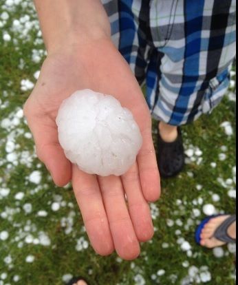
Source: Belgium vs. Tunisia suspended due to insane hail storm
Jun 7, 2014
Derrick Johnson
India Heat Wave Breaks Records, Causes Blackouts and Riots
Angry Indians continue to riot as brutal heat bakes much of northern India, forcing government officials to cut electricity in some places as the power grid becomes strained beyond its capacity.
In New Dehli, widespread blackouts have become a life-threatening concern in the city of 22 million, reports Think Progress. The city is no stranger to sudden power cuts, but with worries about the stressed power grid, electricity has been cut in shopping malls and street lights, leading to deserted streets and shops.
A recent thunderstorm damaged transmission lines, adding to the area's issues, according to Channel News Asia. After days of sweltering heat, residents in northeastern New Delhi went into the streets and damaged cars late Tuesday night.
Weather Underground's Christopher Burt said New Delhi's Palam Airport hit 118 degrees on Sunday – the second-hottest temperature ever measured at that site and a daily record. Some relief is expected in the coming days, but temperatures are not expected to retreat below 100 degrees in New Delhi.
Source: http://www.weather.com/safety/heat/india-heat-wave-20140611
Jun 12, 2014
Derrick Johnson
Bigger climate story of 2014: Record warmth/drought in California or eastern cold?
On Thursday, the National Oceanic and Atmospheric Administration released its monthly “State of the Climate” update for the U.S. These updates always contain a treasure trove of interesting weather and climate news.
In this latest report, the record challenging heat in the Southwest U.S. and unusually cold weather in the eastern half of the country emerge as the two standout climate stories of the year so far.
Statewide temperature rankings January-May 2014 (NOAA)
As the map from the report shows (above), California has had its warmest year on record to date, while 13 states in the eastern U.S. have ranked among the top 10 coldest on record so far.
The warmth in California and surrounding states is closely tied to the severe drought in the region. A hundred percent of California is classified under severe, extreme, or exceptional drought. The drought is having profound consequences for water resources, wildfire risk, and agric....
The cold in the eastern U.S. led to a punishing winter which was linked to a slowdown in economic growth across the entire country. In the Great Lakes, it took until around June 10 for the ice to finally disappear off L....
Source: http://www.washingtonpost.com/blogs/capital-weather-gang/wp/2014/06...
Jun 14, 2014
jorge namour
Extraordinary images of the rare "red spectrum" photographed in the skies of New Mexico [PHOTOS]
Saturday, June 14,2014
http://www.meteoweb.eu/2014/06/straordinarie-immagini-del-rarissimo...
https://translate.google.com/translate?sl=it&tl=en&js=y&...
These spectacular images are due to what is called the red spectrum (sprite): an atmospheric electrical phenomenon still little known. The sprite appears in the upper atmosphere, above storms, and is associated with the ionization of the air.
In summary it comes to electrical discharges such as lightning:
Jun 14, 2014
jorge namour
Naples and Bari- ITALY other incredible images of extreme events of recent days [PHOTOS]
Wednesday, June 18, 2014
Before Naples on Monday, June 16. Then Bari, yesterday afternoon (Tuesday 17). Along with Rome, were the two cities most affected by violent wave of bad weather that rages on Italy since last weekend. In Turin, Milan, Bologna, Riccione, Pesaro and other locations in the center / north there were storms, but the most intense hit the center / south and Sardinia with the destructive flood of Santa Teresa di Gallura. The most violent phenomena, however, were exceptional storm on Monday in Naples (30mm of rain in 20 minutes, the temperature dropped to +14 ° C in the daytime and wind gusts to 110km / h) and the devastating hailstorm yesterday afternoon in Bari, with hundreds of cars destroyed by big grains such as apricots . Here are some photos:
http://www.meteoweb.eu/2014/06/napoli-bari-incredibili-immagini-dei...
https://translate.google.com/translate?sl=it&tl=en&js=y&...
https://translate.googleusercontent.com/translate_c?act=url&dep...
Jun 18, 2014
lonne rey
In addition to Tracey Crespo's post concerning double or twin Toranado
Triple Tornado: never seen in the U.S.
The double tornado that devastated the city of Pilger, Nebraska Monday was actually a triple tornado
The "twin tornadoes" of Nebraska , who shaved 75% of the city of Pilger and caused several casualties, had a little sister. Pictures confirmed the testimony of several people: three simultaneous tornadoes under one storm made landfall.
Source in French
Jun 18, 2014
lonne rey
Coldest June night in 50 years brings summertime snow
The lowest temperature since 1962 was recorded in northern Finland on Tuesday, as large swathes of the country woke up to a blanket of white. Things are forecast to warm up slightly in time for Midsummer celebrations, but the changeable weather is set to stay for the time being, with temperatures ten degrees below average for this time of year.
Snow fell during the night and in the morning in parts of Lapland, northern Ostrobothnia and central Finland. The temperature fell to zero as far south as Virrat in Pirkanmaa.
The coldest June temperature in 50 years was recorded in Saanatunturi, Northern Finland, when the mercury dropped to minus 6.2. That wasn’t quite low enough to beat the 1962 record of minus seven, measured at the start of June in Laanila, northern Lapland.
Source
Jun 19, 2014
Howard
Surprise Storm Dumps Foot of Snow on Parts of the U.S. (Jun 17)
 Over 14" of snow at Sperry Chalet in Glacier National Park since June 17th.
It certainly doesn't feel like summer in Montana's Glacier National Park and parts of Utah and Idaho after an unusual storm moved in, dumping up to a foot of snow.
As a point of reference, Utah typically sees an average daily temperature of 27C in June, while Montana's average June high is around 28 degrees Celcius.
The storm brought more than 100 mm of rain and 30 cm of snow to Montana's Glacier National Park.
The greater challenge will come when the heavy snowfall starts to melt, putting some areas at risk of flooding.
According to the National Weather Service in the U.S., an additional 100+ mm of rain and 20 cm of snow could fall in the mountains before the conditions dissipate this weekend.
Source
http://www.theweathernetwork.com/news/articles/surprise-storm-dumps...
Jun 20, 2014
Derrick Johnson
New Data Confirms May Was Earth's Warmest on Record
Due to widespread record warmth both on land and especially at sea, May was the warmest such month on record since the instrumental record began in 1880, according to the National Oceanic and Atmospheric Administration (NOAA). The NOAA data adds to preliminary NASA data and information from the Japanese Meteorological Agency, all pointing to record warmth for the month.
This was the 39th straight May and 351st straight month with a global average surface temperature above the average for the 20th century. The last below average May occurred in 1976, and the last below average temperature for any month occurred in February 1985 (the month The Breakfast Club hit theaters).
See also: Why You Can't Blame El Niño for Extreme Weather (Yet)
That means that if you are under the age of 30, you have never experienced a month when global average surface temperatures were cooler than average.
Such a long streak of above average temperatures has been tied to increasing amounts of manmade greenhouse gases, such as carbon dioxide, in the atmosphere, which is causing temperatures to increase. Natural climate variability ensures that month-to-month and year-to-year trends can vary, but overall the long-term temperature trend is unmistakably upward.
The combined average temperature over global land and ocean surfaces for May 2014 was 59.93 degrees Fahrenheit, which was 1.33 degrees Fahrenheit above the 20th century average, NOAA said. The margin of error associated with this temperature is plus or minute 0.13 degrees Fahrenheit.
Global average surface temperature departures from average during May, 2014.
Image: NOAA
For the ocean, the May global sea surface temperature was 1.06 degrees Fahrenheit the 20th century average, which was the highest for May on record, surpassing the previous record- holder of 1998 by 0.04 degrees Fahrenheit. According to NOAA, this also ties with June 1998, October 2010, and July 2009 as the highest departure from average for any month on record. During May 1998, El Niño conditions were present in the Pacific, which tends to boost global average temperatures.
There is not yet an El Niño, although NOAA is predicting one will develop by the fall of this year.
Four of the five warmest Mays on record have occurred in the past five years: 2010 (second warmest), 2012 (third warmest), 2013 (fifth warmest), and 2014 (warmest), NOAA said in a report.
The majority of the world saw above average monthly temperatures during May, with record warmth across eastern Kazakhstan, parts of Indonesia, and central and northwestern Australia.
Every major ocean basin on Earth had a section that was record warm, while the northeastern Atlantic, and the northwestern and southeastern Pacific were cooler than average. The average May temperature was record high for South Korea, at 2.2 degrees Fahrenheit above the 1981-2010 average.
Plot of global surface temperature departures from average from 1880 to the present.
Image: NOAA/NCDC
During late May, record heat affected parts of eastern Asia, with Beijing, China seeing its hottest temperature on record for the month, at 106 degrees Fahrenheit on May 30.
Studies show that heat waves are already becoming more intense and long-lasting globally, as average temperatures warm in response to increasing amounts of greenhouse gases in the air.
Source: http://mashable.com/2014/06/23/may-earths-warmest-record/
Jun 24, 2014
KM
http://www.thelocal.no/20140624/mini-tornadoes-stun-southern-norway
Mini-tornadoes stun southern Norway
Published: 24 Jun 2014 13:25 GMT+02:00
Updated: 24 Jun 2014 13:25 GMT+02:00
A succession of rare 'mini tornadoes' have drawn crowds in the city of Arendal as they circled dramatically above the Skagerrak strait between Norway and Denmark.
Jun 25, 2014
KM
http://www.thelocal.no/20140627/record-rainfall-swamps-oslo
Record rainfall swamps Oslo
Published: 27 Jun 2014 12:54 GMT+02:00
Updated: 27 Jun 2014 12:54 GMT+02:00
The torrential rainfall that descended on Oslo on Thursday smashed all historical records, with a colossal 44.5mm of rain falling in just a single hour between four and five on Thursday afternoon.
Jun 27, 2014
Derrick Johnson
Wild weather extremes mark USA's first half of 2014
Crazy extremes of wet and dry weather have both drenched and scorched the USA in the first half of the year.
How crazy? Waterlogged Pensacola, Fla., has received more than 200 times as much rain as bone-dry Las Vegas, which has had only one rainy day this year, Feb. 28, when about one-third of an inch fell.
Though Las Vegas is admittedly in the desert Southwest, the tiny amount is still quite paltry, about one-sixth what the city would usually get at this point in the year. Southwest hot spot Yuma, Ariz., has received less than one-tenth of an inch of rain this year.
The entire state of California — which had its warmest winter on record — slipped into drought conditions this spring, with nearly a third of the state in "exceptional" drought, the worst level. The state is enduring its worst drought since the 1970s. "Unprecedented" May wildfires scorched parts of the state.
On the flip side, torrential rain swamped the Southeast this spring, with April being the worst month. Mobile, Ala., had its wettest April ever, with a foot and a half of rain. The worst of the rain in Pensacola was in late April, when almost 2 feet fell in two days, leading to widespread flooding, sinkholes, road closures and record-high river levels.
Overall, for much of the year, the reason for the split weather pattern was a persistent ridge of high pressure over the western half of the USA, which was balanced by a trough of low pressure in the East, climate scientist Jake Crouch of the National Climatic Data Center said earlier this year.
High pressure usually brings clear skies, while low pressure brings clouds and precipitation.
Other wild weather from the year's first six months:
• A massive mudslide in Oso, Wash., in March, fueled by weeks of unusually heavy rain, killed at least 42 people, making it the third-deadliest in U.S. history.
• The brutally cold winter brought near-record levels of ice to the Great Lakes, wreaking havoc with shipping and wildlife. The ice persisted into June in Lake Superior, the latest on record.
• Detroit picked up an all-time record 7.9 feet of snow for the entire winter season of 2013-14, more than twice the city's average.
• Two inches of snow in Atlanta in late January brought the city to its knees, stranding motorists and school buses overnight. The same storm brought snow as far south as the Florida Panhandle.
• After a very quiet start to the severe weather season, a savage outbreak of tornadoes killed 33 people in the Midwest and South in late April, with the deadliest hitting Arkansas on April 27. June has also seen a flurry of tornadoes in the Plains, the most active June for tornadoes in at least four years.
• Through the end of May, Alaska was baking through its second-warmest year on record. The state had its warmest January since 1985.
Source: http://www.usatoday.com/story/weather/2014/06/27/weather-extremes/1...
Jun 29, 2014
Howard
Waterlogged Canadian Prairies: 150+ mm of Rain Prompts Evacuations, Local States of Emergencies (June 30)
The hardest hit areas include communities along the Saskatchewan/Manitoba border where between 100-200 mm of rain has been recorded since Friday.
Several main highways and secondary roads remain closed and officials say water also covers stretches of the Trans-Canada Highway west of Brandon, Manitoba.
Flights at Brandon's airport have also been disrupted after the facility's main access road was flooded.
Residents are being urged to delay showers, baths, and even flushing toilets to prevent additional strain on the water systems.
In addition to the flooding rains, damaging winds that whipped through Manitoba left hundreds of homes without power over the weekend.
According to hydro spokesperson Scott Powell, they've been overloaded with calls throughout southern Manitoba and the Interlake region, with power lines affected in both urban and rural areas.
Sources
http://www.theweathernetwork.com/news/articles/waterlogged-prairies...
http://www.cbc.ca/news/canada/manitoba/prairie-flooding-prompts-eva...
http://www.theweathernetwork.com/news/articles/ten-photos-flooding-...
Jun 30, 2014
Derrick Johnson
California's Record Hottest Year, So Far, Is 2014: NOAA
California is sweating through its hottest year-to-date in 2014, according to a just-released report.
Statewide temperature rankings for the period January-May 2014. A ranking of 120 (California) means 2014 was the hottest January-May period on record. Conversely, a ranking of 4 (Wisconsin) means the fourth coldest such period on record, dating to 1895. (NOAA/NCDC)
The first five months of 2014 were the hottest on record in the Golden State, according to the May U.S. State of the Climate report from NOAA's National Climatic Data Center, in records dating to 1895.
California's mean January-May temperature of 55.2 degrees was a whopping five degrees above their 20th Century average, topping the previous hottest January-May period there set in the Dust Bowl era (1934).
Los Angeles, San Francisco, San Diego, Fresno and Sacramento all set their record hottest January through May.
Persistent blocking high pressure in the upper atmosphere diverting the jet stream north of the Golden State is the primary factor behind a hot 2014, not to mention one of the worst droughts in decades.
(MORE: Record Dry 2013 | Drought Threatens Food Supply)
Selected cities recording their top three warmest, coldest, wettest or driest January-May in 2014. (NOAA/NCDC)
Notable Heat Elsewhere
Arizona, Oregon, Nevada and Utah also chalked up a top 10 warmest January-May period in 2014.
Las Vegas, Phoenix and Tucson have each registered their hottest year-to-date through May. The year has been among the top three hottest in Salt Lake City, Flagstaff, Arizona, and Medford, Oregon. (see red dots on inset map at right)
Impressive warmth in 2014 extended into the Last Frontier.
The year's first five months were the second warmest such period on record in Alaska, exceeded only by January-May 1981. America's northernmost city, Barrow, Alaska, has had its record warmest January-May.
Not Just the Heat
In parts of the central and eastern U.S., the first five months of 2014 were a completely different story.
Thirteen states from Minnesota to Louisiana east to Pennsylvania shivered in a top 10 coldest January-May on record (see first inset map above).
Chicago, Buffalo, Indianapolis, Toledo, Green Bay, Wisconsin, even the nation's icebox, International Falls, Minnesota chalked up a top three coldest January-May periods in 2014 (see second inset map above for more cities denoted by blue dots).
On the dry side, January through May was the second driest such period on record in Kansas, third driest in Oklahoma and fourth driest in Arizona.
Source: http://www.weather.com/news/science/california-record-hottest-year-...
Jul 1, 2014
KM
http://www.inthesnow.com/resorts/heavy-snow-brings-july-joy-australia/
HEAVY SNOW BRINGS JULY JOY IN AUSTRALIA
RESORTS NEWS | 1 JULY 2014
Australian ski areas – which started their season badly on June 7th with almost no snow following a record warm May, are celebrating snowfalls of up to almost five feet (1.4m in fact) during the last four days.
The snow has now stopped leaving resorts well-covered ahead of the weekend and the country’s school holiday period.
“We expect to have over 40 lifts operating for the weekend across the four resorts areas of Perisher, Smiggin Holes, Blue Cow and Guthega,” said Samantha Hales, Communications and Media Manager at Australia’s biggest resort which now has a 102.1 cm base,
“There is a lot of work to do to get the resort open after a big storm as we need to get out there and groom out the wind drift, build lift tracks and ensure the resorts is safe for guests.”
Meanwhile at Mt Hotham called the snowfall ‘Snowmageddon 1.0’ and are expecting ‘Snowmageddon 2.0’ to follow bon later this weekend,
“Snowmageddon 1.0 started last Monday and brought the snowfall we have all been waiting for. Within 3 days we had over 70cm of snow, got 6 lifts going and are looking forward to the best school holiday skiing and riding in years. Another front is coming in on Saturday and we will be hitting the 1-meter mark by Saturday night/Sunday morning,” said a statement from the resort, which currently has seven lifts running.
Jul 1, 2014