EARTHQUAKES Worldwide! (Frequently Updated)
 Global Earthquake Maps
Regionally Specific Earthquake Maps
|
Related Informations:
Earthquakes during the poleshift Magnetic twist and the effects
|
Additional Information from the F.A.Q: Q: What is the "Earth Wobble"?
Q: How can I understand the Magnetosphere? - About the Magnetosphere
Q: Is there a relationship between disturbances in the magnetosphere and seismic activity? |
Altering Earthquakes:
As of late, I have observed that USGS and EMSC are a bit lax on their reports of earthquakes. Sometimes not seeing anything reported for hours from the last update, or seeing periods of 90-200 minutes with no earthquakes in between. My question is, are they leaving swarms of earthquakes out of their reports, or there are actually periods of no earthquakes?
SOZT: Greater than 90% of the earthquake activity is being altered by the USGS at present, which is under orders to prevent any clue being given to the public about the Earth changes caused by the presence of Planet X. Over a decade ago, the approach was to de-sensitize the live seismographs periodically, so the displays do not turn black worldwide, and to ignore the twice-a-day patterns showing up on these seismographs. Then any quakes that could be dropped were dropped. This was obvious to some who were watching the database manipulation. Quakes in the list would suddenly disappear. This was particularly the case where a quake happened in a remote location, or out in the ocean. Dumbing down the magnitude quickly followed, but in order to ensure the public did not notice, the USGS took control of all websites reporting quake statistics. At times, this control breaks, and discrepancies are reported to the public. Some countries rebel. Quake swarms are another source of control, as they pepper the databases with many quakes and skew the statistics, and thus are pulled from the database. Else the question is raised, why so many? EOZT
Will the USGS internet system be a reliable warning system for the European tsunami by registering on the net the New Madrid earthquake on the exact time it occurs?
SOZT: It will not be a lack of information from the USGS that will be the point of confusion during the earthquakes leading up to the New Madrid adjustment, it will be knowing which quake is the big one vs the many minor quakes preceding it. The USGS downgrades almost all earthquakes, to prevent meaningful statistics from being generated from their databases. They also exclude quakes whenever they can, but this is unlikely to happen in the New Madrid area as it is in the center of a populated land mass. Thus you will have magnitude 6 quakes that will be called a 5.2, magnitude 7 quakes called a 6.1, and when a magnitude 8 or greater quake occurs, it will be called a 6.9.
We would advise that rather than watching the USGS quake statistics, that you watch the Earth changes. The adjustment that will incite the European tsunami will involve bridges on the Mississippi breaking, and being impassable. The land to the west of the Mississippi will drop so that the Mississippi will become 50 miles wide in the state of Mississippi. Watch for this. The New Madrid adjustment will be several large quakes of magnitude 8-9, though will be listed as a lesser magnitude. As the N American continent continues to unzip up to and along the Seaway, the quakes will be less than a magnitude 8 but very destructive to Cleveland and Toledo and Buffalo and the inland locks along the Seaway. Thus it is not what the USGS says that should be watched, but the condition of the bridges on the Mississippi, the impact on the cities along the Seaway, and whether the inland locks are reported as inoperable. EOZT
Please collect earthquake-reports here. Significant Quakes or Magnitude 7+ can be posted separately.
[Edited by the Moderation]
Views: 547988
Comment
-
Comment by Mark on July 14, 2014 at 9:24am
-
Oklahoma now has more earthquakes a year than CALIFORNIA
http://www.dailymail.co.uk/news/article-2690913/Is-fracking-reason-...Is fracking behind the exponential increase in earthquakes suffered across Oklahoma?
That is the question the US Geological Survey wants to know the answer to because as of last month, Oklahoma surpassed California in the number of earthquakes experienced over the past five years.
As of June 16, 2014, California - the home of the infamous San Andreas fault - registered 140 quakes of 3.0-magnitude or greater, which is in stark contrast to Oklahoma's 207.
-
Comment by jorge namour on July 12, 2014 at 1:09am
-
Jul. 11, 2014 - Updated 22:16 UTC
Quake hits Fukushima
An earthquake struck Fukushima and other northeastern Japanese prefectures early Saturday morning.
The quake occurred at about 4:22 AM Japan time.
The Meteorological Agency says the focus is 10 kilometers beneath the Pacific Ocean off Fukushima Prefecture.
The magnitude was estimated at 6.8.
The jolt measured 4 on Japan's seismic intensity scale of zero to 7.
The agency issued a tsunami advisory for Fukushima, Miyagi and Iwate prefectures.
The agency observed a 20 centimeter high tsunami at 5:19 AM in Ishinomaki City, Miyagi Prefecture but lifted its tsunami advisory about two hours later.
Tokyo Electric Power Company says there are no reports of irregularities at the Fukushima Dai-ichi Nuclear Power Plant that was crippled by a major earthquake and tsunami in 2011.
Jul. 11, 2014 - Updated 20:04 UTC
http://www3.nhk.or.jp/nhkworld/english/news/20140712_06.html
Offshore quake rocks northern Japan -- but no tsunamis, no reports of damage
CNN
July 11, 2014 -- Updated 2221 GMT (0621 HKThttp://edition.cnn.com/2014/07/11/world/asia/japan-earthquake/index...
-
Comment by lonne rey on July 11, 2014 at 11:53pm
-
Jersey hit by biggest earthquake in 90 years
The biggest earthquake in Jersey and Guernsey on the Channel Islands for almost 90 years has struck, with a magnitude of 4.2.
Rumbles of sounds were heard as windows rattled when the quake struck at a depth of seven miles around 12 miles west of St Helier at 12.54pm.
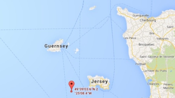
http://www.itv.com/news/update/2014-07-11/jersey-hit-by-biggest-ear...
-
-
2014-07-11 19:22:00.92hr 25min ago 37.13 N 142.40 E 10 6.8 OFF EAST COAST OF HONSHU, JAPAN
http://www.emsc-csem.org/Earthquake/earthquake.php?id=3904452014-07-11 19:59:15.31h 37.19 N 142.17 E 23 4.6 OFF EAST COAST OF HONSHU, JAPAN
-
-
4.4 27km SSW of Soufriere, Dominica 2014-07-10 09:55:00 UTC-03:00 167.0 km
http://earthquake.usgs.gov/earthquakes/eventpage/usb000rrim#summary
3.3 48km SE of Boca de Yuma, Dominican Republic 2014-07-10 08:23:19 UTC-03:00 68.0 kmhttp://feww.wordpress.com/2010/03/25/massive-eruption-soufriere-hil...
Massive Eruption at Soufriere Hills Volcano
Posted by feww on March 25, 2010
Passengers on a 737 jet flying over the Caribbean had a close-up look at a massive volcanic eruption which ejected a plume of ash and smoke higher than the flight altitude. Early reports indicate that a partial collapse of the volcano’s lava dome may have caused the mushroom cloud.
A massive eruption of Montserrat’s Soufrière Hills Volcano triggered by a collapse of Soufrière Hills’ summit lava dome covered large portions of the island in debris on February 11, 2010. Pyroclastic flows raced down the northern flank of the volcano, leveling trees and destroying buildings in the village of Harris, already abandoned after Soufrière Hills activity in 1995. The Montserrat Volcano Observatory reported that some flows, about 15 meters (49 feet) thick, reached the sea at Trant’s Bay, extending the island’s coastline up to 650 meters (2,100 feet).
http://feww.wordpress.com/2010/02/26/more-activity-at-soufriere-hil...
Soufriere Hills Hellbent on Blowing Up Montserrat Island
February 26, 2010
4.9 21km NNW of Cocachacra, Peru 2014-07-09 14:19:39 UTC-03:00 49.6 km
http://earthquake.usgs.gov/earthquakes/eventpage/usb000rraf#summaryVOLCANO shared Volcán Misti's photo.
JULY 10 2014https://www.facebook.com/photo.php?fbid=645056082257893&set=a.4...
After the earthquake of some landslides on volcano Misti, some minutes ago. Strange earthquake that began as an explosion and lasted for little more than one minute. Apparently the quake had increased incidence in mountain by belief that it had its origin in the same. MAS, keep calm and keep us alert
2014-07-10 16:14:3 40.41 N 26.12 E 2 2.8 WESTERN TURKEY
2014-07-10 15 40.40 N 26.13 E 10 3.3 WESTERN TURKEY
2014-07-10 07:58:07.78hr36.02 N 30.21 E 2 4.0 WESTERN TURKEY
2014-07-09 23:45:02.1 40.43 N 26.27 E 15 4.2 WESTERN TURKEY2014-07-10 13:17:59 27.92 S 69.44 W 80 4.4 ATACAMA, CHILE
2014-07-10 10:37:14.34.27 N 117.02 W 7 2.6 SOUTHERN CALIFORNIA
2014-07-10 07:46:52.29hr 02min ago 34.28 N 117.02 W 8 2.4 SOUTHERN CALIFORNIA
http://www.emsc-csem.org/Earthquake/earthquake.php?id=390173
2014-07-10 07:09:47 38.82 N 122.82 W 3 2.7 NORTHERN CALIFORNIA
2014-07-10 05:35:47.111 36.83 N 97.96 W 2 2.7 OKLAHOMA
2014-07-09 16:25:26.5 35.88 N 97.27 W 5 2.5 OKLAHOMA014-07-10 08:58:54.87hr 51min ago 36.77 N 140.64 E 10 4.9 NEAR EAST COAST OF HONSHU, JAPAN
2014-07-10 07:16:18.8 19.84 S 175.70 W 223 5.3 TONGA
2014-07-10 02:59:50.4 10.27 N 85.21 W 48 4.3 COSTA RICA
2014-07-10 01:42:47.9 35.86 N 30.69 E 60 3.0 EASTERN MEDITERRANEAN SEA
http://www.emsc-csem.org/Earthquake/earthquake.php?id=390136
2014-07-09 15:37:24.2 35.29 N 30.52 E 40 3.3 EASTERN MEDITERRANEAN SEA2014-07-09 18:36:22.9 36.89 N 3.92 W 62 4.3 STRAIT OF GIBRALTAR FELT
http://www.emsc-csem.org/Earthquake/earthquake.php?id=3900742014-07-09 17:58:11.0 62.09 S 164.99 E 2 5.2 BALLENY ISLANDS REGION
http://www.emsc-csem.org/Earthquake/earthquake.php?id=3900702014-07-09 15:17:22.7 6.58 S 147.22 E 91 5.0 EASTERN NEW GUINEA REG., P.N.
2014-07-09 13:35:17.7 55.13 N 165.26 E 40 5.0 KOMANDORSKIYE OSTROVA REGI
http://www.emsc-csem.org/Earthquake/earthquake.php?id=3900562014-07-09 11:14:10.2 25.96 S 179.66 E 509 4.9 SOUTH OF FIJI ISLANDS
2014-07-09 10:08:41.5 14.77 N 92.55 W 66 4.5 OFFSHORE CHIAPAS, MEXICO
2014-07-09 09:07:54.9 14.91 N 92.51 W 60 4.1 CHIAPAS, MEXICO2014-07-09 08:12:35.1 55.28 S 28.36 W 20 4.8 SOUTH SANDWICH ISLANDS REGI
2014-07-09 07:11:53.0 22.23 S 67.83 W 212 4.2 POTOSI, BOLIVIA
2014-07-09 06:03:08.6 9.68 S 111.51 E 40 4.7 SOUTH OF JAVA, INDONESIA
2014-07-09 05:37:02.6 0.48 S 123.15 E 39 4.3 SULAWESI, INDONESIA2014-07-09 09:08:38.3 36.75 N 42.76 E 19 2.5 IRAQ
http://www.emsc-csem.org/Earthquake/earthquake.php?id=390023
2014-07-09 01:15:50.5 34.23 N 45.35 E 2 3.2 IRAN-IRAQ BORDER REGION2014-07-09 02:10:04.3 37.10 N 97.77 W 1 3.4 KANSAS
http://www.emsc-csem.org/Earthquake/earthquake.php?id=3899592014-07-09 00:01:30.6 6.95 S 104.87 E 10 5.2 SUNDA STRAIT, INDONESIA
2014-07-08 22:57:15.4 29.77 N 116.47 W 15 4.3 OFFSHORE BAJA CALIFORNIA, MEXICO
http://www.emsc-csem.org/Earthquake/earthquake.php?id=3899482014-07-08 21:52:48.7 39.39 N 78.28 E 10 5.0 SOUTHERN XINJIANG, CHINA
2014-07-08 18:18:43.7 36.56 N 77.38 E 90 4.5 SOUTHERN XINJIANG, CHINA2014-07-08 20:10:02.3 3.25 S 143.29 E 20 5.3 NEAR N COAST OF NEW GUINEA, PNG
2014-07-08 17:31:19.0 4.89 N 96.12 E 20 4.6 NORTHERN SUMATRA, INDONESIA
-
-
6.3 13km NNE of Port-Vila, Vanuatu 2014-07-08 09:56:26 UTC-03:00 114.0 km
http://earthquake.usgs.gov/earthquakes/eventpage/usc000rrmg#summary2014-07-08 16:04:20. 20.78 S 70.52 W 38 4.6 OFFSHORE TARAPACA, CHILE SWARM
2014-07-08 15:35:42.12h36.30 N 73.96 E 80 4.9 NORTHWESTERN KASHMIR
2014-07-08 15:08:33.62hr 36.76 N 98.05 W 5 2.8 OKLAHOMA
2014-07-08 12:39:21.1 33.87 N 119.41 W 15 2.6 CHANNEL ISLANDS REG., CALIFORN
2014-07-08 12:31:46 33.16 N 115.65 W 2 3.2 SOUTHERN CALIFORNIA2014-07-08 14:43:32.53 52.01 N 178.57 E 120 4.8 RAT ISLANDS, ALEUTIAN ISLANDS
2014-07-08 14:35:40.3 33.07 S 178.51 W 10 4.9 SOUTH OF KERMADEC ISLANDS
2014-07-08 14:05:31.23hr 49min ago 35.93 N 23.55 E 5 4.2 CRETE, GREECE STRONG SWARM
http://www.emsc-csem.org/Earthquake/earthquake.php?id=389860
014-07-08 13:41:28.9 5.55 S 147.31 E 192 4.3 EASTERN NEW GUINEA REG., P.N.G.
2014-07-08 13:33:22. 20.64 S 178.10 W 471 4.6 FIJI REGION2014-07-08 13:27:47.0 33.90 S 72.46 W 36 4.0 OFFSHORE O'HIGGINS, CHILE
2014-07-08 13:25:24. 33.88 S 72.39 W 2 4.5 OFFSHORE O'HIGGINS, CHILE2014-07-08 11:10:26.36hr 45min ago 17.60 S 174.56 W 166 4.4 TONGA
2014-07-08 10:46:39. 6.99 S 154.82 E 34 4.5 BOUGAINVILLE REGION, P.N.G.
2014-07-08 09:05:2 42.70 N 141.47 E 10 5.5 HOKKAIDO, JAPAN REGION
http://www.emsc-csem.org/Earthquake/earthquake.php?id=3898082014-07-08 09:01:29.78hr 52min ago 36.69 N 121.33 W 5 3.1 CENTRAL CALIFORNIA
2014-07-08 08:53:51.38hr 59min ago 37.65 N 118.85 W 7 2.4 LONG VALLEY AREA, CALIFORNIA
2014-07-08 08:29:34.79hr 24min ago 37.66 N 118.85 W 7 2.4 LONG VALLEY AREA, CALIFORNIA
http://www.emsc-csem.org/Earthquake/earthquake.php?id=389803
2014-07-08 08:17:47.29hr 35min ago 36.70 N 121.33 W 5 3.1 CENTRAL CALIFORNIA
2014-07-08 01:08:10.7 37.87 N 122.25 W 10 2.4 SAN FRANCISCO BAY AREA, CALIF.
2014-07-08 00:16:47.6 39.20 N 119.73 W 10 3.2 NEVADA
10hr 40min ago 37.66 N 118.85 W 7 2.3 LONG VALLEY AREA, CALIFORNIA
2014-07-08 05:31:15.3 36.77 N 121.48 W 7 3.2 CENTRAL CALIFORNIA2014-07-08 08:16:4 18.90 N 65.36 W 5 2.8 PUERTO RICO REGION
2014-07-08 08:1 18.92 N 67.51 W 120 2.9 PUERTO RICO REGION2014-07-08 04:33:33.5 27.73 N 142.89 E 30 4.8 BONIN ISLANDS, JAPAN REGION
2014-07-08 02:13:08.4 59.24 S 149.06 E 10 4.7 WEST OF MACQUARIE ISLAND
http://www.emsc-csem.org/Earthquake/earthquake.php?id=3897582014-07-08 01:23:24.4 7.18 S 129.95 E 140 5.0 KEPULAUAN BABAR, INDONESIA
2014-07-07 23:51:40.3 36.90 N 29.35 E 18 3.3 WESTERN TURKEY SWARM
2014-07-07 23:02:36.1 49.26 S 164.72 E 25 4.4 AUCKLAND ISLANDS, N.Z. REGION
http://www.emsc-csem.org/Earthquake/earthquake.php?id=3897432014-07-07 20:48:47.8 53.95 N 160.88 W 2 4.9 SOUTH OF ALASKA
2014-07-07 18:04:35.6 5.29 S 131.71 E 60 5.0 BANDA SEA
2014-07-07 17:21:55.3 46.90 N 153.24 E 33 4.2 KURIL ISLANDS
2014-07-07 15:50:06.1 47.33 N 151.26 E 80 4.6 KURIL ISLANDS2014-07-07 15:09:25.5 24.09 S 67.37 W 211 4.3 SALTA, ARGENTINA
http://www.emsc-csem.org/Earthquake/earthquake.php?id=3896622014-07-07 14:38:21.5 34.07 N 97.47 W 7 3.2 OKLAHOMA
2014-07-07 13:59:40.8 36.21 N 97.55 W 5 2.5 OKLAHOMA
2014-07-07 07:44:15.4 36.68 N 98.09 W 11 3.0 OKLAHOMA
2014-07-07 03:56:01.0 36.02 N 97.10 W 8 2.6 OKLAHOMA
2014-07-07 03:52:09.9 36.84 N 98.08 W 2 2.5 OKLAHOMA2014-07-07 10:14:30.9 46.61 N 28.23 W 10 4.2 NORTHERN MID-ATLANTIC RIDGE
2014-07-07 10:07:14.8 19.03 N 67.85 W 35 4.3 DOMINICAN REPUBLIC REGION
2014-07-07 10:01:16.9 19.17 N 67.98 W 65 2.9 DOMINICAN REPUBLIC REGION
2014-07-07 07:13:07.0 19.63 N 68.47 W 93 3.7 DOMINICAN REPUBLIC REGION2014-07-07 09:15:29.2 7.32 S 123.74 E 554 5.4 BANDA SEA
2014-07-07 02:40:42.2 41.95 N 142.69 E 85 4.5 HOKKAIDO, JAPAN REGION
2014-07-06 22:11:31.9 21.08 S 173.86 E 10 5.7 VANUATU REGION
http://www.emsc-csem.org/Earthquake/earthquake.php?id=3895302014-07-06 17:08:40.9 10.04 S 12.07 W 10 4.9 ASCENSION ISLAND REGION
http://www.emsc-csem.org/Earthquake/earthquake.php?id=38949807-06 14:48:12.7 30.41 N 80.27 E 48 4.2 WESTERN XIZANG-INDIA BORDER REG.
2014-07-06 11:42:44.6 10.35 N 85.19 W 60 4.9 COSTA RICA FELT
2014-07-06 10:15:58.0 19.46 N 104.31 W 100 4.2 JALISCO, MEXICO FELT
2014-07-06 10:13:38.0 15.54 S 167.40 E 55 4.7 VANUATU
2014-07-06 04:24:56.5 32.53 N 109.16 W 5 3.5 ARIZONA
FELT
http://www.emsc-csem.org/Earthquake/earthquake.php?id=389406
-
-
2014-07-07 11:23:58.92hr 00min ago 14.91 N 92.28 W 90 7.0 CHIAPAS, MEXICO STRONG
http://www.emsc-csem.org/Earthquake/earthquake.php?id=389631
http://www.emsc-csem.org/#22.6 10km E of Mammoth Lakes, California 2014-07-07 09:46:01 UTC-03:00 7.3 km
2.6 10km E of Mammoth Lakes, California 2014-07-07 09:32:08 UTC-03:00 7.6 km
2.9 10km E of Mammoth Lakes, California 2014-07-07 09:27:11 UTC-03:00 7.6 km
http://earthquake.usgs.gov/earthquakes/eventpage/nc72251511#summary
http://earthquake.usgs.gov/earthquakes/map/
-
-
Big Bear Lake 4.6 earthquake causes rock slides, rattles San Bernardino County, California
The Southland was rattled Saturday morning by two earthquakes and a cluster of aftershocks that hit just north of Big Bear Lake and caused rock slides that temporarily closed Highway 18 between Snow Valley and Arctic Circle, but road crews were able to clean up the area and reopened the highway by about 12:30 p.m.
The largest temblor measured 4.6 magnitude, according to the U.S. Geological Survey.
-
-
Earthquake hits Hudson Highlands; rattled residents take to streets
GARRISON, NEW YORK – People living in the Hudson Highlands were startled Saturday morning by an earthquake that didn't shake the ground, but was accompanied by a loud boom.
The "micro earthquake" struck at 10:46 a.m., 3.1 miles beneath the Appalachian Trail in a heavily wooded area of Garrison.
The Lamont-Doherty Cooperative Seismographic Network reported on its website that it was a magnitude-2.5 earthquake. The location, according to Lamont-Doherty, was 13 miles southeast of Newburgh, and 23 miles north-northwest of White Plains. The coordinates, 41.36 north and 73.934 west, place it a few miles north of Peekskill.
Most people in the Lower Hudson Valley didn't hear or feel a thing. But those near the epicenter were startled into the streets.
-
-
- 2014-07-05 23:41:4 32.45 N 49.82 E 10 4.0 WESTERN IRAN
2014-07-05 23:09:21.1 36.78 N 8.10 W 30 3.0 WEST OF GIBRALTAR FELT
http://www.emsc-csem.org/Earthquake/earthquake.php?id=3893852014-07-05 22:25:15.81hr 33.64 N 35.48 E 8 3.6 LEBANON - SYRIA REGION
http://www.emsc-csem.org/Earthquake/earthquake.php?id=389387
2014-07-05 21:41:36.32hr 23min ago 33.57 N 35.47 E 15 4.0 LEBANON - SYRIA REGION
http://www.emsc-csem.org/Earthquake/earthquake.php?id=389366Magnitude Mc 4.0
Region LEBANON - SYRIA REGION
Date time 2014-07-05 21:41:36.3 UTC
Location 33.57 N ; 35.47 E
Depth 15 km
Distances 35 km S of Beirut, Lebanon / pop: 1,916,100 / local time: 00:41:36.3 2014-07-06
9 km E of Sidon, Lebanon / pop: 163,554 / local time: 00:41:36.3 2014-07-06http://www.dailystar.com.lb/News/Lebanon-News/2014/Jul-06/262795-mi...
Jul. 06, 2014 | 12:47 AM (Last updated: July 06, 2014 | 01:41 AM)
Mild tremor shakes LebanonRead more: http://www.dailystar.com.lb/News/Lebanon-News/2014/Jul-06/262795-mi...
(The Daily Star :: Lebanon News :: http://www.dailystar.com.lb)BEIRUT: A mild tremor shook several areas in Lebanon, including the capital, Beirut, early Sunday, residents said.
The European Mediterranean Seismological Center said the epicenter of the 4.0-magnitude earthquake was at sea, 47 km southwest of Beirut.
There was no immediate word of damage or casualties in Lebanon.
Lebanon is criss-crossed by numerous fault lines, and the last major earthquake is estimated to have killed 40,000 people in 1759. Experts say that Lebanon can expect major earthquakes every 250-300 years.
In A.D. 551, Beirut was largely destroyed by a major earthquake, estimated as a 7.6-magnitude, which also spawned a tsunami that caused widespread devastation along the eastern Mediterranean.
2014-07-05 21:16:35 49.34 N 120.49 W 1 2.3 BRITISH COLUMBIA, CANADA
2014-07-05 20:22:55.73 42.34 N 142.90 E 46 4.9 HOKKAIDO, JAPAN REGION
2014-07-05 17:30:55.4 23.13 S 69.91 E 33 4.6 MID-INDIAN RIDGE
http://www.emsc-csem.org/Earthquake/earthquake.php?id=3893264.6 11km WNW of Big Bear Lake, California 2014-07-05 13:59:34 UTC-03:00 8.7 km
http://earthquake.usgs.gov/earthquakes/eventpage/ci15520985#summary
2.7 10km WNW of Big Bear Lake, California 2014-07-05 14:01:23 UTC-03:00 7.1 km
3.4 10km WNW of Big Bear Lake, California 2014-07-05 14:00:26 UTC-03:00 6.5 km
http://earthquake.usgs.gov/earthquakes/map/http://ktla.com/2014/07/05/earthquake-with-4-6-magnitude-shakes-sou...
Earthquake With 4.6-Magnitude Shakes Southern California
A 4.6-magnitude earthquake struck near Big Bear Lake on July 5, 2014. (Credit: USGS)
A magnitude-4.6 earthquake struck near Big Bear Lake around 10 a.m. Saturday, according to the U.S. Geological Survey.
Nearby cities included Lake Arrowhead and Highland, according to USGS.
Multiple KTLA viewers reported feeling the quake in areas between Pasadena and Rancho Mirage.
The earthquake was initially reported to be 4.8 magnitude by USGS.
2014-07-05 14:59:33. 37.37 N 141.83 E 30 4.9 NEAR EAST COAST OF HONSHU, JAPAN
2014-07-05 14:46:39. 41.36 N 73.93 W 5 2.5 NEW YORK
http://www.emsc-csem.org/Earthquake/earthquake.php?id=389321
2014-07-05 17:07:33.8 37.37 N 121.77 W 2 2.4 SAN FRANCISCO BAY AREA, CALIF.2014-07-05 15:11:12 34.05 S 71.48 W 45 2.9 REGION METROPOLITANA, CHILE
2014-07-05 08:54:45.0 33.92 S 71.34 W 48 4.3 REGION METROPOLITANA, CHILE FELT
http://www.emsc-csem.org/Earthquake/earthquake.php?id=389258
2014-07-05 11:00:44.3 20.71 S 70.87 W 2 4.4 OFFSHORE TARAPACA, CHILE2014-07-05 12:04:56.9 51.58 N 16.10 E 2 4.6 POLAND
http://www.emsc-csem.org/Earthquake/earthquake.php?id=3892896.0 88km SE of Sinabang, Indonesia 2014-07-05 06:39:30 UTC-03:00 30.0 km FELT EMSC
http://earthquake.usgs.gov/earthquakes/eventpage/usc000rqs7#summary
4.7 116km SE of Sinabang, Indonesia 2014-07-05 07:02:13 UTC-03:00 28.1 km2014-07-05 07:55:22.7 39.37 N 142.75 E 55 4.4 NEAR EAST COAST OF HONSHU, JAPAN
2014-07-05 06:22:35.2 11.92 N 87.10 W 47 4.1 NEAR COAST OF NICARAGUA
2014-07-05 06:19:45.9 46.42 N 10.59 E 9 2.4 NORTHERN ITALY
2014-07-05 05:15:20.0 45.59 N 153.45 E 33 4.0 EAST OF KURIL ISLANDS
2014-07-05 04:13:03.7 51.82 N 178.66 E 101 4.9 RAT ISLANDS, ALEUTIAN ISLAND
2014-07-05 03:50:07.8 44.36 N 17.48 E 2 3.6 BOSNIA AND HERZEGOVINA FELT
2014-07-05 03:34:46.8 5.00 S 153.71 E 60 4.8 NEW IRELAND REGION, P.N.G.
2014-07-05 01:16:56.4 6.09 S 152.77 E 30 4.8 NEW BRITAIN REGION, P.N.G.2014-07-05 03:11:47.8 28.20 N 55.14 E 10 4.7 SOUTHERN IRAN
2014-07-05 01:18:14.2 30.54 S 177.93 W 40 5.2 KERMADEC ISLANDS, NEW ZEALAND
2014-07-04 22:42:04.9 39.72 N 142.04 E 46 5.7 NEAR EAST COAST OF HONSHU JAPAN
http://www.emsc-csem.org/Earthquake/earthquake.php?id=3891722014-07-04 21:18:00.2 34.03 N 117.17 W 8 2.4 GREATER LOS ANGELES AREA, CALIF.
2014-07-04 21:08:46.0 35.16 N 34.98 W 10 5.2 AZORES ISLANDS REGION
http://www.emsc-csem.org/Earthquake/earthquake.php?id=389154
© 2024 Created by 0nin2migqvl32.
Powered by
![]()
You need to be a member of Earth Changes and the Pole Shift to add comments!
Join Earth Changes and the Pole Shift