"We warned at the start of ZetaTalk, in 1995, thatunpredictable weather extremes, switching about from drought to deluge,would occur and increase on a lineal basis up until the pole shift. Where this occurred steadily, it has only recently become undeniable. ZetaTalk, and only ZetaTalk, warned of these weather changes, at that early date. Our early warnings spoke to the issue of global heating from the core outward, hardly Global Warming, a surface or atmospheric issue, but caused by consternation in the core. Affected by the approach of Planet X, which was by then starting to zoom rapidly toward the inner solar system for its periodic passage, the core was churning, melting the permafrost and glaciers and riling up volcanoes. When the passage did not occur as expected in 2003 because Planet X had stalled in the inner solar system, we explained the increasing weather irregularities in the context of the global wobble that had ensued - weather wobbles where the Earth is suddenly forced under air masses, churning them. This evolved by 2005 into a looping jet stream, loops breaking away and turning like a tornado to affect the air masses underneath. Meanwhile, on Planet Earth, droughts had become more intractable and deluges positively frightening, temperature swings bringing snow in summer in the tropics and searing heat in Artic regions, with the violence of storms increasing in number and ferocity."
The wobble seems to have changed, as the temperature in Europe suddenly plunged after being like an early Spring, Alaska has its coldest temps ever while the US and much of Canada is having an extremely mild winter. India went from fatal cold spell to balmy again. Has the Earth changed position vs a vs Planet X to cause this?[and from another]Bitter cold records broken in Alaska - all time coldest record nearly broken, but Murphy's Law intervenes[Jan 30]http://wattsupwiththat.com/2012/01/30/bitter-cold-records-broken-in-alaskaJim River, AK closed in on the all time record coldest temperature of -80°F set in 1971, which is not only the Alaska all-time record, but the record for the entire United States. Unfortunately, it seems the battery died in the weather station just at the critical moment. While the continental USA has a mild winter and has set a number of high temperature records in the last week and pundits ponder whether they will be blaming the dreaded "global warming" for those temperatures, Alaska and Canada have been suffering through some of the coldest temperatures on record during the last week.
There has been no change in the wobble pattern, the wobble has merely become more severe. Nancy noted a Figure 8 format when the Earth wobble first became noticeable, in early 2005, after Planet X moved into the inner solar system at the end of 2003. The Figure 8 shifted along to the east a bit on the globe between 2005 and 2009, (the last time Nancy took its measure) as Planet X came closer to the Earth, encountering the magnetic N Pole with a violent push earlier in the day. But the pattern of the Figure 8 remained essentially the same. So what changed recently that the weather patterns became noticeably different in late January, 2012?
The N Pole is pushed away when it comes over the horizon, when the noon Sun is centered over the Pacific. This regularly puts Alaska under colder air, with less sunlight, and thus the historically low temps there this January, 2012 as the wobble has gotten stronger. But by the time the Sun is positioned over India, the N Pole has swung during the Figure 8 so the globe tilts, and this tilt is visible in the weather maps from Asia. The tilt has forced the globe under the hot air closer to the Equator, warming the land along a discernable tilt demarcation line.
The next loop of the Figure 8 swings the globe so that the N Pole moves in the other direction, putting the globe again at a tilt but this time in the other direction. This tilt is discernable in weather maps of Europe, again along a diagonal line. Depending upon air pressure and temperature differences, the weather on either side of this diagonal line may be suddenly warm or suddenly cold. The tilt and diagonal line lingers to affect much of the US and Canada, but the Figure 8 changes at this point to be an up and down motion, pulling the geographic N Pole south so the US is experiencing a warmer than expected winter under a stronger Sun. Then the cycle repeats, with the magnetic N Pole of Earth pushed violently away again as the Sun is positioned over the Pacific.
Would the Zetas be able to let us know what is causing the early break-up of the Arctic Ice, the ice seems to have taken on a swirling pattern at the same time, would this be wobble related?[and from another]http://www.vancouversun.com/news/national/Canada+Arctic+cracks+spec... The ice in Canada’s western Arctic ripped open in a massive “fracturing event” this spring that spread like a wave across 1,000 kilometres of the Beaufort Sea. Huge leads of water – some more than 500 kilometres long and as much as 70 kilometres across – opened up from Alaska to Canada’s Arctic islands as the massive ice sheet cracked as it was pushed around by strong winds and currents. It took just seven days for the fractures to progress across the entire area from west to east.[and from another]http://earthobservatory.nasa.gov/IOTD/view.php?id=80752&src=iot... A high-pressure weather system was parked over the region, producing warmer temperatures and winds that flowed in a southwesterly direction. That fueled the Beaufort Gyre, a wind-driven ocean current that flows clockwise. The gyre was the key force pulling pieces of ice west past Point Barrow, the northern nub of Alaska that protrudes into the Beaufort Sea.
The Figure 8 formed by the N Pole during the daily Earth wobble has shifted somewhat to the East, due to Planet X positioned more to the right of the Earth during its approach. This was anticipated, and well described in ZetaTalk, the Earth crowding to the left in the cup to escape the approach of Planet X, so the angle between these two planets would change slightly. This shift of the Figure 8 to the East is due to the push against the Earth’s magnetic N Pole occurring sooner each day than prior. Thus instead of occurring when the Sun is high over the Pacific, over New Zealand, it is now occurring when the Sun is high over Alaska. All the wobble points have shifted eastward accordingly.
This has brought a lingering Winter to the western US, and a changed sloshing pattern to the Arctic waters. Instead of Pacific waters being pushed through the Bering Straits into the Arctic when the polar push occurs, the wobble is swinging the Arctic to the right, and then later to the left, creating a circular motion in the waters trapped in the Arctic. Since the Earth rotates counterclockwise, the motion also takes this path. This is yet another piece of evidence that the establishment is hard pressed to explain. They are attempting to ascribe this to high pressure and wind, all of which are not new to the Arctic, but this circular early breakup of ice in the Arctic is new.
Moisture from Tropical Storm Eta met up with a cold front to dump rain on the Tarheel State.
Floodwaters forced more than 140 people to evacuate a school Thursday morning in Charlotte as torrential rains lashed much of North Carolina washing out roads and bridges and flooding homes and businesses.
At least seven deaths have been blamed on the flooding.
An11-year-old child was found drownedafter going missing near a creek in Rolesville, about 16 miles northeast of Raleigh, the Wake County Sheriff's Office reported.
Three peoplewere found deadand two people were unaccounted for after floodwaters inundated a North Carolina campground, according to a news release from officials in Alexander County, North Carolina.
Crews saved 31 people when the South Yadkin Riverflooded the Hiddenite Family Campground, the Mooresville Fire chief told WBTV. The campground is in the Alexander County community of Hiddenite, about 60 miles northwest of Charlotte.
The body of one person was found inside a camper, Alexander County Sheriff Chris Bowman said at a briefing Thursday afternoon. Rescuers later reported finding the body of two other victims.
Bowman said another person died in the storm when their car ran off the road into floodwaters. Overall in Alexander County, 50 roads were damaged and four bridges washed away.
Trooper C.B. Saunders of the North Carolina Highway Patrol saidtwo people died in a crashon Wilkesboro Highway outside of Statesville Thursday morning, the Statesville Record & Landmark reported. The Highway Patrol said the pickup was going too fast “for the wet conditions of the roadway and hydroplaned,” according to the Charlotte Observer.
Video tweeted by the Fire Department showed cars in the school's parking lot submerged up to their windows. Students and faculty were beingsheltered under tents set up nearby, WBTV reported.
Extensive damage also was reported across Iredell County, which surrounds Statesville, North Carolina.
Several roads and bridges washed out, according to social media posts from the area. Three people had to be rescued from a flooded home.
Numerous accidents were reported, including a jack-knifed semitractor-trailer on southbound Interstate 77.
Floodwaters washed out a large section of Liberty Hill Road in Iredell County on Thursday, November 12, 2020, near Statesville, North Carolina.
(Twitter/@IredellFirewire)
Neighboring Catawba County declared a state of emergency, County Commission Chairman Randy Isenhower said, “due to excessive rain causing flooding, power outages, road closures and hazardous conditions.”
Dozens of schools delayed the start of classes or shifted to online only classes because of the flooding. Schools in the eastern part of the state closed early after the rains reached them.
The Winston-Salem Fire Departmentevacuated 38 peoplefrom the Colonial Estates apartments when floodwater rose around the building, the Winston-Salem Journal reported. Firefighters also used inflatable boats to move people from the Creekwood Apartments.
Firefighters with the Winston-Salem Fire Department evacuate residents at Creekwood Apartments as flood waters rise on Thursday, November 12, 2020, in Winston-Salem, North Carolina.
The weather was blamed formultiple car crashes in Raleigh, where Walnut Creek also overflowed, flooding neighborhood streets, WRAL reported.
In Wilson County, east of Raleigh, first responders have conductedat least 20 water rescuessince Wednesday, Gordon Deno, the county's emergency management director, told the Wilson Times. Deno said no injuries were reported.
Across the state line in South Carolina, several people had to be rescued from flooded homes in York County.
From 9 a.m Wednesday to 9 a.m. Thursday, more than 8 inches of rain fell in some locations, theNational Weather Service reported, including 8.78 inches in Fayetteville in Cumberland County and 8.6 inches in Rocky Mount in Nash County. In Wilson County, 7.66 inches fell in Wilson.
Tropical moisture from Eta has surged northward at the same time a cold front is moving through the Eastern states, according to weather.com meteorologist Chris Dolce. This collision has resulted in a widespread area of rainfall across the East since Wednesday. Some of the most intense rainfall and worst flooding has occurred from Virginia into North Carolina, especially Thursday morning.
All-time November snow records broken for parts of the Canadian Prairies
A strong low-pressure system brought blizzard conditions, heavy snow and freezing rain to parts of the Canadian Prairies on November 7 and 8, 2020, shutting down roads in Saskatchewan and Alberta and setting new all-time November snow records. While heavy snow fell in western parts of Saskatchewan, its eastern regions experienced freezing rain. Several more cm of snow is expected through the end of the week.
The town of Kindersley in Saskatchewan recorded 47.6 cm (18.7 inches) of snow on Saturday and Sunday, November 7 and 8, setting a new 48-hour snowfall record.
Kindersley recorded 11.6 cm (4.5 inches) on Saturday; and 35.8 cm (14 inches) on Sunday, breaking the previous 24-hour snowfall record of 21.3 cm (8.3 inches) set on March 17, 1974.
"To put the weekend's snowfall in perspective, the nearly 48 cm that recently accumulated is more than Kindersley saw in November, December, January and February 2019," Brittany Warner of West Central Online reports.
"Those four months totaled 43.8 cm (17.2 inches) combined, approximately 4 cm (1.5 inches) less than what fell this weekend."
Bigger and Leader have also broken November 2019 snow totals with 21.1 cm (8.3 inches) in Bigger in 48 hours -- which is 6 cm (2.3 inches) more than the entire November 2019 -- and 23.1 cm (9 inches) in Leader. In November 2019, Leader recorded a total of 12.8 cm (5 inches).
Image credit: NOAA/GOES-East. Acquired: 18:30 UTC on November 8, 2020
Between 15 and 20 cm (5.9 - 7.8 inches) was recorded in the city of Regina, and nearly 30 cm (11.8 inches) in Saskatoon. Saskatoon's current 24-hour snow record is 36 cm (14.1 inches) set on January 7, 2007.
Pamela Goulden-McLeod - Saskatoon director of emergency management
Prince Albert recorded 37 cm (14.5 inches) of snow, Codette 33 cm (12.9 inches) and Limerick 31 cm (12 inches).
Rosetown reported 16.8 cm (6.6 inches) over the weekend, just a bit more than it recorded during the entire November 2019.
Winter storm and blizzard warnings have all been dropped by Monday, but travel is still not recommended, the Weather Network reports.
Bitter wind chills will span much of the Prairies on Monday afternoon in the wake of the departing system.
"So a good reminder that if you are traveling today with those bitter wind chills, make sure you have an emergency kit with you because some roads could still be closed or very treacherous," says Weather Network meteorologist Jaclyn Whittal.
On January 14, 2020, Kindersley broke its daily all-time coldest temperature record with -37 °C (-34.6 °F). The previous record was -34 °C (-29.2 °F) set in 2005. Interestingly, the town's warmest January 14 was set in 2008 with +5.7 °C (42.2 °F).
The city of São Paulo suffered from heavy rains this afternoon. Firefighters answered 44 calls for floods, 40 for falling trees and 4 for landslides, according to information updated at 18h02. One of the trees hit a person on the streetAratangi, in Cachoeirinha, but there is still no information on the victim’s health status.
The capital of São Paulo entered into a state of attention for flooding from 2:12 pm, according to data from the CGE (Center for Management of Climate Emergencies). In the North Zone, heavy rain dragged cars that were inside a car wash and piled vehicles, according to information from Globo News.
Another large tree fell on top of a residence in the Santana neighborhood. “The north zone was very affected by the rains, especially the area of Avenida Engenheiro Caetano Álvares, close to the Marginal Tietê”, said the Fire Department Captain, André Elias, in an interview for Globo News. “But there is no person at risk of life, injured or missing. We are only helping those who are stranded.”
Also according to the CGE, the Casa Verde and Sé neighborhoods went on alert due to the overflow of the streamsMandaquieSaracunarespectively, but thestatusit was closed at 16:30. The Ipiranga Stream left the alert at 5:10 pm.
At 5:20 pm, the CGE decreed the end of the state of attention in all regions. Heavy rains also hindered traffic in the late afternoon: according to information from CET (Companhia de Engenharia de Trafico), the northern part of São Paulo, where the Marginal Tietê is located, registered18kmslow at 5:40 pm. In the city center,13kmof slowness.
The dark sky was registered by some residents and the click was shared on social networks.
Flooding points
According to information from the CGE, there were 20 active flooding points in the city of São Paulo. In the north, the Freguesia do Ó neighborhood had a flooded street. At Casa Verde, two of the three floods recorded by the CGE were classified as “impassable”. The points are on Quirinópolis Street and Praça Delegado Amoroso Neto.
In Santana, the CGE recorded two other points with the flow of cars interrupted by the rains: on the avenues Cruzeiro do Sul and Zaki Narchi. In the Cathedral, Praça da Bandeira was impassable.
Flooding in the neighborhoods of Lapa and Vila Mariana also prevented the circulation of cars in the region: on Rua Barão do Bananal and on Avenida Vinte and Três de Maio, respectively. Butantã, Pinheiros and Ipiranga also suffered flooding because of the rains.
These were the details of the news Rain causes flooding and tree falls in SP for this day. We hope that we have succeeded by giving you the full details and information. To follow all our news, you can subscribe to the alerts system or to one of our different systems to provide you with all that is new.
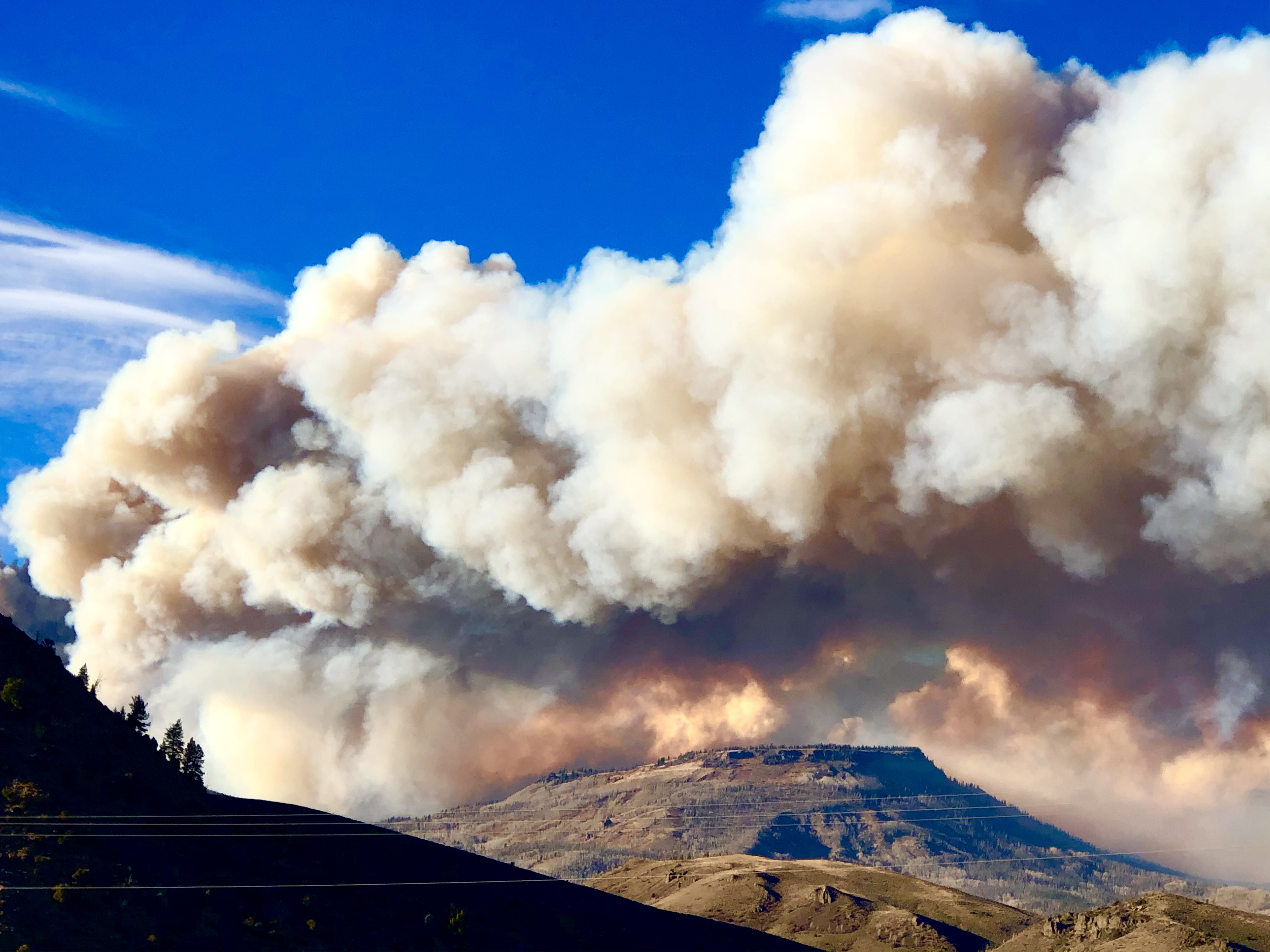
East Troublesome Fire Explodes To 170,000 Acres: ‘Really Unheard Of’
The East Troublesome Fire grew almost another 50,000 acres on Thursday, after growing about 100,000 acres Wednesday night. As of Thursday evening, the fire was estimated at 170,000 acres — making it the second largest fire in Colorado history.
East Troublesome Fire
“We prepare for the worst. This is the worst of the worst of the worst,” Grand County Sheriff Brett Schroetlin said.
There are concerns the fire could merge with theCameron Peak Fire, which has burned over 200,000 acres.
“It is a potential, and certainly this year has been one of those years where those low potential events seem to be happening with high frequency,” Noel Livingston, incident commander, said Thursday night. “And, you know, a fire of this size, moving this far in October is a very low potential event in terms of what we would expect, and it’s occurred.”
“I don’t want to say you can’t happen right now. It doesn’t appear that it’s going to,” Livington said.
Livingston called it “an amazing amount of fire spread” in a Thursday morning briefing.
“Obviously yesterday was a significant fire day,” said the fire manager. “We saw about 20 miles of fire growth through the afternoon and into the night, which equates to about 100,000 acres of additional fire activity.”
“That’s really unheard of for a fire in this part of the world, in timber,” Livingston said Thursday evening.
Livingston said the East Troublesome Fire’s growth on Wednesday can be explained by several factors: strong winds, excessively dry conditions, low relatively humidity and beetle-kill trees among the fuels in the high elevations the wildfire spread through.
Wildfires across parts of the country have so far killed two people and forced many to flee; Lebanon and Israel also hit by blazes.
Massive forest fires in war-torn Syria this week have killed at least two people and burned swaths of land, state media and officials said, as blazes also hit neighbouring Lebanon.
Syrian state television on Saturday morning broadcast scenes from the affected areas, where firefighters were working to extinguish the blazes.It said hundreds of hectares had burned in the countryside of Syria’s coastal Latakia and Tartus provinces, and in the central Homs province.
The health ministry said two people died in Latakia province on Friday as a result of the fires, and that 70 people in the area were taken to hospital suffering from breathing difficulties.
Dozens of fires were burning, including “45 in Latakia and 33 in Tartus”, Syria’s Agriculture Minister Mohammed Hassan Qatana told a radio station on Friday.
“For the first time in its history, Syria is witnessing this [large] number of fires in a single day,” Qatana said.
The Latakia fire brigade said they were “facing the largest series of fires seen in Latakia province in years”.
Official news agency Sana said fires burned homes in the coastal city of Banias in Tartus province, as well as in Qardahah, President Bashar al-Assad’s hometown in Latakia.
Fires heavily damaged a building in Qardahah used as a storage for the state-owned tobacco company, part of which collapsed. The town’s local hospital was also surrounded by flames, according to local media reports.
State news agency SANA quoted Bassem Douba, director of the forestry department in Latakia’s agricultural department, as saying that dozens of people were evacuated from their homes in several villages. Those people sought refuge in central Latakia and Tartus, he said.
At least four firefighting teams were dispatched from the capital, Damascus, to assist in putting out the blazes. Some residents helped them by carrying water in buckets and pouring them on the flames.
The fires raging across Syria’s north, for the second time in months, were triggered by a heatwave that is unusual for this time of the year. They will likely cause considerable financial damage amid a deep economic crisis crippling the country.
Syria is currently suffering from an acute shortage in fuel ahead of the winter months, while power cuts have become more frequent across a country ravaged by more than nine years of war.
Among those affected by the devastating fires are landowners and farmers who rely on the agriculture sector to get by.
Images circulated on social media portrayed citrus and olive trees engulfed in flames in villages on the outskirts of Latakia.
Fires in Lebanon, Israel
Next door in Lebanon, meanwhile, there have been more than 100 fires across the country since Thursday, according to George Abu Musa, head of operations for the country’s civil defence.
“The situation is crazy, there are fires everywhere,” Abu Musa told the AFP news agency. “We have mobilised 80 percent of our personnel and almost all our centres in Lebanon,” he said.
There have been no reports of casualties in Lebanon.
Abu Musa said most of the blazes had been extinguished but some were still burning in the mountainous Chouf region in the south, and in Akkar in the north.
Military helicopters were assisting firefighters in “hard-to-reach” areas, he added. He was unable to identify the cause of the blazes but said wind and high temperatures were helping them spread.
Dozens of fires hit Lebanon in mid-October last year, amid unusually high temperatures and strong winds.
The government faced heavy criticism and accusations of ill-preparedness over its response to the 2019 blazes.
Days after Lebanon’s 2019 fires, mass protests broke out, triggered by proposed tax hikes but quickly transforming into months-long demonstrations against the ruling class, deemed by protesters as inept and corrupt.
Separately on Friday, authorities reported several fires across northern and central Israel and the occupied West Bank as temperatures soared, forcing thousands to evacuate.
Israeli police said in a statement firefighters and police forces evacuated 5,000 people as the fires spread for a second day on Saturday.
Hurricane Delta 'rapidly intensifies' to Category 4 storm, takes aim at Cancun before US Gulf Coast —Louisiana to the Florida Panhandle may be impacted by the storm
Delta has rapidly strengthened into a Hurricane. It'll continue to get stronger with even a Major Hurricane (Category 3+) possible Tuesday into Wednesday. The northern Gulf coast, especially Louisiana, needs to monitor for landfall on Friday.
France sends in the army while rescue teams hunt for survivors in Italy as torrential rain and winds from Storm Alex leave at least two dead and up to 20 missing while landslides devastate buildings and roads
Houses were buried in mud and turned-over cars stuck in the riverbed in the French village of Breil-sur-Roya
In northwestern Italy the 'historic' flooding destroyed a section of a bridge over the Sesia river
French Prime Minister Jean Castex has deployed the army as 20 people on his side of the border remain unaccounted for after the flash floods washed away houses and triggered landslides
In Italy, a 53-year-old firefighter died during a rescue mission in the Aosta Valley, and a 36-year-old man died after his car was swept away by a river in Piedmont
The army has been deployed inFranceand rescue teams are hunting for survivors inItalyafter torrential rain and winds from Storm Alex left two dead and 20 missing.
Breil-sur-Roya, a French village close to the Italian border, was a scene of devastation with houses buried in mud and turned-over cars stuck in the riverbed.
In northwestern Italy the 'historic' flooding destroyed a section of a bridge over the Sesia river.
'There are very many people of whom we have no news,' Castex said.
On the Italian side of the border several villages were also still cut off, and many roads blocked.
A 53-year-old firefighter died during a rescue mission in the Aosta Valley, and a 36-year-old man died after his car was swept away by a river in Piedmont.
French rescue efforts were concentrated on the Roya valley where around 1,000 firefighters backed up by helicopters and army units resumed their search hoping to find survivors, and giving assistance to people whose homes were destroyed or inaccessible
Storm Alex barrelled into France's west coast on Thursday bringing powerful winds and rain across the country before moving into Italy, where regions across the north suffered an onslaught on Saturday.
'What we are going through is extraordinary,' the prefect of the Alpes-Maritimes region said Bernard Gonzalez.
'We are used to seeing images of such disasters on other continents, sometimes with a lack of concern, but this here is something that affects us all,' he said.
France has declared the region a natural disaster zone.
Local authorities gave shelter to some 200 people overnight, while food and thousands of bottles of water were being airlifted into remote villages cut off by the storms.
Gonzalez called on the families of the missing people not to give up hope.
'Just because their loved ones haven't been able to get in touch doesn't mean that they have been taken by the storm,' he said.
Many landline and some mobile phone services were disrupted, with some villages using satellite phones to communicate with rescue services.
Despite forecasts of more rain, rescue efforts were to continue throughout Sunday, Gonzalez said.
'The helicopter procession will continue all day long,' he said, adding however that the prospect of more heavy weather was 'a worry'.


You need to be a member of Earth Changes and the Pole Shift to add comments!
Join Earth Changes and the Pole Shift