"We warned at the start of ZetaTalk, in 1995, thatunpredictable weather extremes, switching about from drought to deluge,would occur and increase on a lineal basis up until the pole shift. Where this occurred steadily, it has only recently become undeniable. ZetaTalk, and only ZetaTalk, warned of these weather changes, at that early date. Our early warnings spoke to the issue of global heating from the core outward, hardly Global Warming, a surface or atmospheric issue, but caused by consternation in the core. Affected by the approach of Planet X, which was by then starting to zoom rapidly toward the inner solar system for its periodic passage, the core was churning, melting the permafrost and glaciers and riling up volcanoes. When the passage did not occur as expected in 2003 because Planet X had stalled in the inner solar system, we explained the increasing weather irregularities in the context of the global wobble that had ensued - weather wobbles where the Earth is suddenly forced under air masses, churning them. This evolved by 2005 into a looping jet stream, loops breaking away and turning like a tornado to affect the air masses underneath. Meanwhile, on Planet Earth, droughts had become more intractable and deluges positively frightening, temperature swings bringing snow in summer in the tropics and searing heat in Artic regions, with the violence of storms increasing in number and ferocity."
The wobble seems to have changed, as the temperature in Europe suddenly plunged after being like an early Spring, Alaska has its coldest temps ever while the US and much of Canada is having an extremely mild winter. India went from fatal cold spell to balmy again. Has the Earth changed position vs a vs Planet X to cause this?[and from another]Bitter cold records broken in Alaska - all time coldest record nearly broken, but Murphy's Law intervenes[Jan 30]http://wattsupwiththat.com/2012/01/30/bitter-cold-records-broken-in-alaskaJim River, AK closed in on the all time record coldest temperature of -80°F set in 1971, which is not only the Alaska all-time record, but the record for the entire United States. Unfortunately, it seems the battery died in the weather station just at the critical moment. While the continental USA has a mild winter and has set a number of high temperature records in the last week and pundits ponder whether they will be blaming the dreaded "global warming" for those temperatures, Alaska and Canada have been suffering through some of the coldest temperatures on record during the last week.
There has been no change in the wobble pattern, the wobble has merely become more severe. Nancy noted a Figure 8 format when the Earth wobble first became noticeable, in early 2005, after Planet X moved into the inner solar system at the end of 2003. The Figure 8 shifted along to the east a bit on the globe between 2005 and 2009, (the last time Nancy took its measure) as Planet X came closer to the Earth, encountering the magnetic N Pole with a violent push earlier in the day. But the pattern of the Figure 8 remained essentially the same. So what changed recently that the weather patterns became noticeably different in late January, 2012?
The N Pole is pushed away when it comes over the horizon, when the noon Sun is centered over the Pacific. This regularly puts Alaska under colder air, with less sunlight, and thus the historically low temps there this January, 2012 as the wobble has gotten stronger. But by the time the Sun is positioned over India, the N Pole has swung during the Figure 8 so the globe tilts, and this tilt is visible in the weather maps from Asia. The tilt has forced the globe under the hot air closer to the Equator, warming the land along a discernable tilt demarcation line.
The next loop of the Figure 8 swings the globe so that the N Pole moves in the other direction, putting the globe again at a tilt but this time in the other direction. This tilt is discernable in weather maps of Europe, again along a diagonal line. Depending upon air pressure and temperature differences, the weather on either side of this diagonal line may be suddenly warm or suddenly cold. The tilt and diagonal line lingers to affect much of the US and Canada, but the Figure 8 changes at this point to be an up and down motion, pulling the geographic N Pole south so the US is experiencing a warmer than expected winter under a stronger Sun. Then the cycle repeats, with the magnetic N Pole of Earth pushed violently away again as the Sun is positioned over the Pacific.
Would the Zetas be able to let us know what is causing the early break-up of the Arctic Ice, the ice seems to have taken on a swirling pattern at the same time, would this be wobble related?[and from another]http://www.vancouversun.com/news/national/Canada+Arctic+cracks+spec... The ice in Canada’s western Arctic ripped open in a massive “fracturing event” this spring that spread like a wave across 1,000 kilometres of the Beaufort Sea. Huge leads of water – some more than 500 kilometres long and as much as 70 kilometres across – opened up from Alaska to Canada’s Arctic islands as the massive ice sheet cracked as it was pushed around by strong winds and currents. It took just seven days for the fractures to progress across the entire area from west to east.[and from another]http://earthobservatory.nasa.gov/IOTD/view.php?id=80752&src=iot... A high-pressure weather system was parked over the region, producing warmer temperatures and winds that flowed in a southwesterly direction. That fueled the Beaufort Gyre, a wind-driven ocean current that flows clockwise. The gyre was the key force pulling pieces of ice west past Point Barrow, the northern nub of Alaska that protrudes into the Beaufort Sea.
The Figure 8 formed by the N Pole during the daily Earth wobble has shifted somewhat to the East, due to Planet X positioned more to the right of the Earth during its approach. This was anticipated, and well described in ZetaTalk, the Earth crowding to the left in the cup to escape the approach of Planet X, so the angle between these two planets would change slightly. This shift of the Figure 8 to the East is due to the push against the Earth’s magnetic N Pole occurring sooner each day than prior. Thus instead of occurring when the Sun is high over the Pacific, over New Zealand, it is now occurring when the Sun is high over Alaska. All the wobble points have shifted eastward accordingly.
This has brought a lingering Winter to the western US, and a changed sloshing pattern to the Arctic waters. Instead of Pacific waters being pushed through the Bering Straits into the Arctic when the polar push occurs, the wobble is swinging the Arctic to the right, and then later to the left, creating a circular motion in the waters trapped in the Arctic. Since the Earth rotates counterclockwise, the motion also takes this path. This is yet another piece of evidence that the establishment is hard pressed to explain. They are attempting to ascribe this to high pressure and wind, all of which are not new to the Arctic, but this circular early breakup of ice in the Arctic is new.
The UK has been hit by nearly a hundred large wildfires in 2019, making it the worst year on record already.
The hot spell in February and the recent Easter heatwave have contributed to a total of 96 major wildfires of 25 hectares or larger, eclipsing the previous high of 79 across the whole of 2018.
More than 100 firefighters battled wildfires over the Easter weekend across Illkley Moor and Marsden Moor in West Yorkshire. Another fire broke out on moorland near Marsden on Tuesday afternoon, requiring ten fire engines to attend.
Fires throughout the year
There were also wildfires in Cornwall, Dorset, Derbyshire, Northern Ireland, the Peak District, Rotherham, Wiltshire and Wales, according to the National Fire Chiefs Council (NFCC).
Scotland was affected by fires across the Highlands, including a large one that posed a “serious risk” to the Moray windfarm.
The spate of blazes follows a series of major wildfires during the hot, dry weather of 2018, including theSaddleworth Moor fire near Manchester, which burned for five days and made pollution levels spike.
Paul Hedley, national wildfires lead for the NFCC, said it was “really significant” that the number of large wildfires in 2019 had already overtaken 2018’s tally so early in the year.
The big change he has observed is that the wildfires are no longer confined to the traditional season of fires from late March to late September. “What seemed to happen last year and is happening this year, is we are not talking about a wildfire season – we are getting significant wildfires happening throughout the year,” says Hedley.
The scale and duration of the wildfires was a huge stretch on fire and rescue service resources, Hedley adds.
Spring is the point in the year when flammability peaks, with the most dead leaf and woody matter available to burn, says Thomas Smith of the London School of Economics, in the UK.
Layered on top of that seasonal risk has been fire-friendly weather and an increased risk of ignition through accidents, such as a barbeque in the case of the West Yorkshire blazes, or arson.
“Both the fires in February and over this Easter weekend coincided with long warm dry periods with steady easterly winds – fire weather – and also with ignition risk from school holidays,” says Smith.
Weather that is conducive to wildfires has become more likely in recent decades, with the average length of warm spells increasing from5.3 to 13.2 days in recent years.
“I would argue that those statistics suggest that we are already experiencing climate change and that it has already led to increasing wildfire risk,” Smith adds. He says the past two years have been the worst for UK wildfires that he can remember.
The total area burned in 2019 so far is 17,199 hectares, almost on a par with the highs of 2018 and 2011, but with eight months of the year left to go.
The following sequence of model maps in 6-hour intervals covers the interval from April 23 at 06h UTC to April 25 at 00h UTC. Note the ‘tongue’ of dust pushing across France into the British Isles and Ireland at the beginning of the interval extend into the northern Atlantic and reach Iceland by late on April 24 and then push further into the Strait of Denmark towards Greenland. Meanwhile dust pushes across central into eastern Europe as far as the Baltic states, Poland and Ukraine and as far north as southern Sweden.
Large dust loads persist over the central Mediterranean: the southern coast of the Mediterranean in Tunisia, Libya and Egypt, across Malta and south Italy, into Greece and western Turkey.
While Saharan dust events are not rare, particularly across the Mediterranean and southern Europe, the current one is very extensive and is producing major dust loads.
Locals couldn’t have anticipated this: Snowboarding in Western Australia in April?
The state’s southwest had more than a Good Friday, with residents waking up to record snowfall. As predicted in news.com.au’s weekend weather forecast, the Stirling Ranges have seen snow just in time for Easter — and for the first time in 49 years.
While snow this time of year is extremely rare, the Stirling Ranges have broken April records this weekend with residents enjoying the earliest recorded snow event in a calendar year in the state’s history.
The last recorded fall before this time was April 20, 1970, according to Bureau of Meteorology (BOM) records.
And the frost could potentially spread across the Wheatbelt by Sunday morning.
The unseasonal weather has seen Perth residents snow boarding in their yards and making their way to the 1099-metre tall bluffs to get their own snaps for social media. And those who couldn’t make the trek, anticipated the traffic if they tried.
BOM forecaster Matt Boterhoven told the ABC snow was an extremely rare occurrence in April.
“It’s exceptional. We’ve only recorded once, in the last 100 years, snow as early as this on top of the Stirling Ranges,” he said.
“It’s related to a very strong cold air mass moving over the southwest of the state, so when conditions get below freezing and there’s precipitation, snow can form on top of Stirling Ranges.”
GOOD FRIDAY RECORD BREAKER! ❄️
Today’s snowfall on Bluff Knoll was the earliest ever recorded in WA.
The previous record was April 20, 1970.
There’s a chance of more snow on the highest peaks of the Stirling Range overnight Pictures: Davis Redman, Chris Black, Kate Hutcheon pic.twitter.com/KYBbJU8wwn
"Fingers nearly snapped off, but I’m an official member of the WA Bluff Knoll Ski Club," one social media user proudly posted. Source: Twitter @jackwschmidtSource:Twitter
The cold snap also saw Albany and the Great Southern hit by hail at 1pm on Friday.
With temps predicted to peak at 13C and 18C over the next couple of days, locals can expect Friday’s cold front to stick around until Monday.
Comment by SongStar101 on April 16, 2019 at 11:01pm
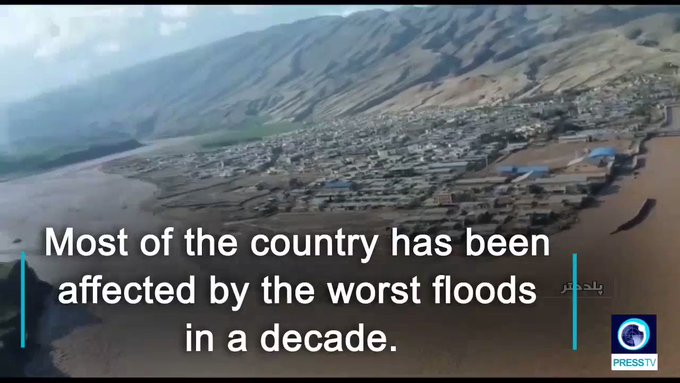
Iran leader approves tapping sovereign fund for flood relief
DUBAI: Iran’s Supreme Leader Ayatollah Ali Khamenei has approved drawing up to US $2 billion (RM8.2 billion) from the country’s sovereign wealth fund for relief and reconstruction after devastating floods, state media reported today.
Yesterday, Interior Minister Abdolreza Rahmani Fazli said the weeks of heavy rain across the country had caused an estimated US$2.5 billion in damage to roads, bridges, homes and farmland. Iran’s worst floods in 70 years had killed at least 76 people and forced more than 220,000 into emergency shelters, state media cited ministers as telling lawmakers.
“Using the National Development Fund is authorised if no other sources are available,” Ayatollah Ali Khamenei said in a letter to President Hassan Rouhani read out today on state television.
However, he urged the government to explore other budgetary measures to fund the relief efforts before tapping the sovereign fund.
In Geneva, the International Federation of Red Cross and Red Crescent Societies said today an estimated two million people needed humanitarian assistance as a result of the floods.
It had launched an international emergency appeal seeking 5.1 million Swiss francs to expand support by Iran’s Red Crescent to an additional 30,000 families — equivalent to about 150,000 people.
Khamenei’s letter did give an amount but Morteza Shahidzadeh, head of the sovereign wealth fund, said earlier that Rouhani had asked to withdraw US$2 billion and Khamenei had in principle agreed.
The fund is worth about US$92 billion, according to the Sovereign Wealth Fund Institute, which tracks the industry.
The floods have affected 4,400 villages, damaged 14,000km of roads and destroyed more than 700 bridges. They have left aid agencies struggling to cope and the armed forces have been deployed to help those affected.
Iran’s government has said it will pay compensation to all those who have incurred losses, especially farmers, but the state budget is already stretched as US sanctions on its energy and banking sectors have halved oil exports and restricted access to some revenues abroad.
Iranian officials have repeatedly said the floods have not affected oil production and development, nor impeded the flow of crude through pipelines to client markets. — Reuters
From mid-March to April 2019, widespread flash flooding affected large parts of Iran, most severely in Golestan, Fars, Khuzestan, Lorestan, and other provinces. Iran has been hit by three major waves of rain and flooding over the course of two weeks[6] which led to flooding in at least 26 of Iran's 31 provinces[7] and at least 70 people died nationwide as of 6 April, according to the officials.[7] The first wave of rain began on 17 March, leading to flooding in two northern provinces, Golestan and Mazandaran with the former province receiving as much as 70 percent of its average annual rainfall in single day.[7] Several large dams have been overflowed, particularly in Khuzestan and Golestan, therefore many villages and several cities have been evacuated.[6] About 1,900 cities and villages across country have been damaged by severe floods as well as hundreds of millions of dollars of damage to water and agriculture infrastructure. 78 roads were blocked and the reliability of 84 bridges was questioned.[8][9]
Severity of the floods was greatly increased by converting flood routes and dry river beds for urban development without providing proper drainage infrastructure.[10] According to an Iranian official, due to record rainfalls, more than 140 rivers have burst their banks and about 409 landslides have happened in the country. The impact of the floods was heightened because of the Nowruz holiday; many Iranians were travelling and many deaths occurred due to flash flooding on roads and highways.[8] Around 12,000 km of roads were damaged by the flooding, about 36% of Iran's national road network.[3] The floods caused at least $2.2 billion (2019 USD) in damages, mostly due to losses in the agricultural industry.[5] Further, according to Red Crescent, two million people are in need of humanitarian aid due to the devastating floods.[11]
A total humanitarian crisis as many still await relief assistence on rooftops. 4500+ livestock dead, farms completely destroyed. BBC Videographer explains how problems could have been minimized had public been able to plan for this type of situation and not built homes and livelihoods near rivers and outlets.
-----------------------------------------
Not long ago 2019, one extreme to the other, Iran was experiencing drought of epic proportions. Water resources were in question all over the country.
Iran drought turns political as lawmakers fight over water share
Local tensions over water resources in Iran are not a novelty either. In recent years, the crisis has not only worsened but has also witnessed new implications. Provinces that were traditionally considered water-rich areas — such as west Azerbaijan, east Azerbaijan, Kohgiluyeh and Boyer-Ahmad, Chahar Mahal and Bakhtiari, Khuzestan, Mazandaran, Gilan and Golestan — are already battling it out to win the bigger share, bringing the fight to political levels in the open...
Comment by SongStar101 on April 13, 2019 at 10:26am
Spring and Winter blending together in US recently.
Blizzard Hits Central U.S. a Day After States Bask in Spring Sunshine
KANSAS CITY, Mo. — Pack away the sidewalk tables and flip-flops; break out the boots and shovels.
Nature was showing its fickle side on Wednesday, with blizzard conditions, heavy snow and frigid air pounding parts of the Rockies and the Plains, just a day after the weather was sunny and idyllic. Schools and highways were shut down, hundreds of flights were canceled, and some communities braced for floods.
The storm, caused by a low-pressure system moving east from the Pacific Ocean, dropped temperatures by up to 50 degrees in places like Denver, where it was sunny and in the mid-70s on Tuesday but reached the mid-20s by Wednesday night. The low-pressure system was affecting areas from Colorado to Michigan, with heavy snow and thunderstorms, and even down into Texas, where dry conditions and high winds led to wildfire warnings.
While the whipsawing forecasts drew groans, they did not come as much of a surprise to those familiar with springtime in the Plains and the Rockies.
“In Colorado, that’s not uncommon at all,” said Natalie Sullivan, a meteorologist with the National Weather Service in Boulder, Colo., noting that April is historically the state’s second-snowiest month of the year, behind March. “We have warm conditions, and then a weather system will come through and bring cold air from a different region, and then — boom — you have snow coming down.”
Ahead of the storm on Wednesday, Gov. Jared Polis activated the Colorado National Guard, and about 50 soldiers were prepared to respond to stranded drivers. State officials also shut down a highway in the eastern part of the state and part of a highway that cuts through the mountains, citing numerous accidents.
“Reopening is up to Mother Nature,” the Colorado State Patrol said on Twitter.
Even before the low-pressure system reached the Rockies, it wreaked havoc on the West Coast, knocking out power in Los Angeles and kicking up dust storms in Nevada, according to AccuWeather.
Officials in states across the Midwest watched anxiously for weather dangers.
Much of the region is still reeling from severe flooding brought on by storms and rising rivers last month. The floods inundated small towns and created a humanitarian crisis on the Pine Ridge Native American reservation, where tribe members found themselves trapped in their homes with little access to food.
Officials in Hamburg, Iowa, worked quickly to add a temporary five-feet-tall levee to the town’s current levee system before the Missouri River crests by Sunday or Monday, as they expect. Floodwaters inundated much of the town of 1,100 people last month after heavy rain accumulated on frozen ground in the region.
“We’ll build that levee and vigilantly watch throughout the night in case flood does come,” said Cathy Crain, the Hamburg mayor.
More pressing than Hamburg’s weather, Ms. Crain said, was the snow and rain in cities to the north, such as Yankton, S.D. When precipitation hits those areas hard, it swells the Missouri River and flows down into Hamburg.
“We are so busy we don’t have emotions,” she said. “We are just moving to recover and to protect our town.”
Meteorologists predicted as much as two and a half feet of snow in parts of eastern South Dakota.
Forecasters were hoping that the long-term effects of this storm would not be as severe as those that set off the flooding last month. A heavy snowfall takes time to melt and run off into rivers and streams, reducing the chance of flooding, meteorologists say, while heavy rain brings faster runoff and greater danger. Warmer temperatures in recent days have also thawed the ground, meaning it should better absorb moisture.
Still, Gov. Kristi Noem of South Dakota ordered state offices closed on Wednesday. Schools also closed in Rapid City, S.D., where several inches of snow fell and the streets became icy. State officials closed a roughly 125-mile stretch of Interstate 29 on Wednesday, from Brookings to the North Dakota border.
It was not all that unusual to have a heavy snowfall in Rapid City in April, said Domico Rodriguez, the general manager of Hotel Alex Johnson. But this was different, he said, because the two-degree wind chills sweeping through the city came just three days after he was out playing softball in 70-degree weather.
“It’s disheartening,” he said, adding that it was difficult to believe the forecast.
In downtown Minneapolis, where snow was falling at a brisk pace, Chameera Ekanayake spent his lunch break huddled beneath a small ledge, trying without much success to keep the flakes out of his hair.
The snow was an unwelcome development in a weather-weary city. After a harsh winter, he said Minnesotans had “been sick of it for a while” and hopeful that the snow was done for the season.
“We had some pretty good days in the last couple weeks and so were like, ‘Yeah, this is the end of it,’” said Mr. Ekanayake, 32, who works in local government.
He said he planned to work from home on Thursday, when conditions were expected to worsen.
In Denver, the storm canceled more than 700 flights into and out of the city, postponed baseball games and sent businesses into shelter mode.
The turn in the weather had Mitchell Carroll, the general manager at a Denver restaurant called Illegal Pete’s, longing for the sunny skies last week that had helped put the restaurant far ahead of its sales totals from a year ago.
Prospects were not looking good for Illegal Pete’s 130-seat patio this week. “You’re not really sure because Coloradans aren’t really fazed by weather,” Mr. Carroll said.
“But if it’s a blizzard warning,” he added, they might stay in.
Comment by jorge namour on April 9, 2019 at 6:39pm
SEOUL, South Korea - A giant forest fire swept across swathes of South Korea Friday, as authorities declared a rare national disaster, deploying 900 fire engines and tens of thousands of personnel to bring it under control.
Apocalyptic images on television and social media showed walls of flame lighting up the night, buildings ablaze, and clouds of smoke billowing across hillsides during the day.
The fire broke out late Thursday alongside a road in the town of Goseong, in the far northeast of the country and only around 45 kilometers from the border with the nuclear-armed North.
Fanned by strong winds, it quickly spread through the mountainous area, incinerating 400 homes and 500 hectares of land, according to the government. CONTINUE...
Massive damage to agricultural sector, 36 percent of roads damaged, more than 60 people dead, Iran
Heavy rain and floods affecting Iran since March 19,2019caused massive damage to the country's agricultural sector, damaged 36% of the entire road network and left at least 62 people dead, as of April 4, 2019.
According to information provided by official sources, flooding has caused at least 47 trillion rials (about $350 million USD) to the country's agricultural sector.
While the government assures flood-affected farmers that all losses will be compensated, speaker of parliament, Ali Larijani,saidthe new year budget would not suffice to cover the damages.
36% of the country's entire road network has been damaged, 84 bridges and nearly 2 200 rural roads washed away.
"Across 15 provinces, 141 rivers burst their banks and around 400 landslides were reported," a spokesman for the National Disaster Management Organisation, told state TV.
About 1 900 cities and villages have been affected in 25 of Iran's 31 provinces.
At least 62 people have been killed so far and 86 000 people moved to emergency shelters.
Authorities say they are dealing with extreme flooding and heavy rainfall which at times equaled more than half of the annual average within 24 hours.
Golestan Province, for example, received 70% of its annual rainfall in just one day. This is unprecedented for the past 300 years, IFRC said.
Government Warns Of Historic, Widespread Flooding “Through May” – Food Prices To Skyrocket As 1000s Of Farms Are Destroyed
According to the U.S. Department of Agriculture, any wheat, corn or soybeans that are contaminated by flood waters must be destroyed.
I know that I shared the following quote yesterday, but in order to give you an idea of the scope of the losses we are looking at, I want to share it again…
As of Dec. 1, producers in states with flooding – including South Dakota, Nebraska, Kansas, Minnesota, Iowa, Missouri, Wisconsin and Illinois – had 6.75 billion bushels of corn, soybeans and wheat stored on their farms – 38 percent of the total U.S. supplies available at that time, according to U.S. Department of Agriculture data.
And remember, the flooding is just getting started.
In just one county in Iowa, 1.8 million bushels of corn and soybeans have already been destroyed. Nationwide, the losses are off the charts.
Needless to say, prices will be going way up at the grocery store, and they will keep going up for the rest of the year.
Sadly, even after the flood waters are gone the damage that has been done to our agricultural infrastructure will take years to repair…
As the waters began to recede in parts of Nebraska, the damage to the rural roads, bridges and rail lines was just beginning to emerge. This infrastructure is critical for the U.S. agricultural sector to move products from farms to processing plants and shipping hubs.
The damage to roads means it will be harder for trucks to deliver seed to farmers for the coming planting season, but in some areas, the flooding on fields will render them all-but-impossible to use.
In Nebraska alone, hundreds of miles of rural roads have been completely washed out, and farmers such as Annette Bloom are having an extremely difficult time just getting to a main road…
“We are having to travel three miles through pasture and cropland just to get out because our roads are gone,” she says. “And the corn fields are going to be devastating to get in and plant and get that going, because usually we’re planting within the next two weeks and it’s not going to happen.”
Much of Nebraska was inundated with flood waters, with the governor describing it as the worst disaster in state history.
Nebraska Governor Pete Ricketts said farmers will suffer the most, calling it the “the most widespread destruction we have ever seen in our state’s history,” CBS News reported.
Ricketts declared a state of emergency over the floodwaters.
According to USA Today, 74 cities, 65 counties, and four tribal areas were under a state of emergency as of March 19.


You need to be a member of Earth Changes and the Pole Shift to add comments!
Join Earth Changes and the Pole Shift