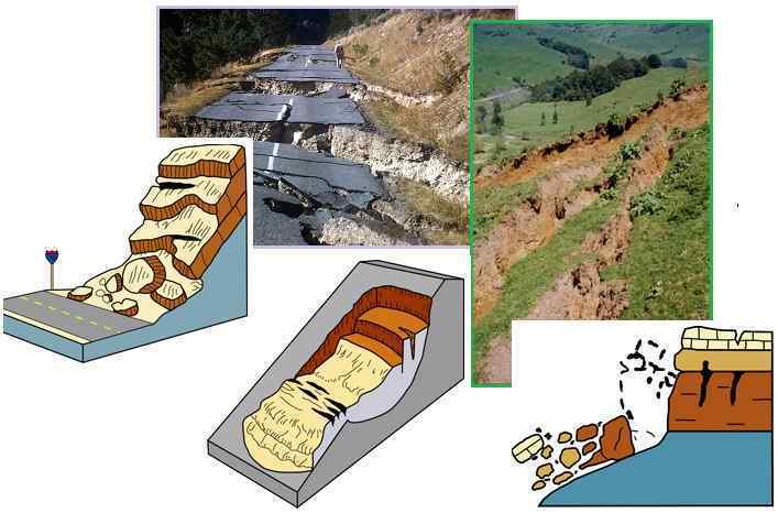
"The causes of landslides are not a mystery to mankind. Layers of rock and soil such that rain running along a clay or rock layer can create a slippery surface for the weight of the layers above it is a common cause. A rock jumble from previous mountain building, broken or fractured rock easily dislodged. We have stated that the earthquakes man experiences between the periodic passages of Planet X can be considered aftershocks from the last passage, and this is true of landslides also. Mountain building rumples the landscape, so the land is not flat but has steep ravines and hill sides. Older mountain ranges are recognized for their rounded or smoothed appearance, because of frequent landslides distributing the rubble.

"As we approach another passage, another Pole Shift, the pace of landslides has picked up. Why would this be? Plates under pressure will put pressure on regions that contain rumpled hillsides and deep ravines, as these give more readily than strictly flat land, thus act as a weak link. In addition, due to the wobble, the weather has gotten more extreme, with drought and deluge increasing in extremes. Dry ground, suddenly flooded with rainwater needing to seek its level as runoff, will create internal water slides between the rock and soil layers that constitute the rumpled hillsides. Is there an early warning system that mankind could use? The trembles that soil about to slide emits could be detected, yes. These are not earthquakes, and have their own frequency. "

ZetaTalk Chat Q&A: March 22, 2014

Views: 122067

Comment

You need to be a member of Earth Changes and the Pole Shift to add comments!

Join Earth Changes and the Pole Shift

Comment by Khan on June 13, 2018 at 2:41pm

Costa Rica: Huge landslide in  Pérez Zeledón.

Jun 12, 2018

Paso towards Pérez Zeledón by La Cangreja will remain closed until Wednesday due to landslide.


The aerial images better illustrate the dimension of the collapse that interrupted the passage towards Pérez Zeledón along the South Interamerican highway.

The passage towards Pérez Zeledón by La Cangreja will remain closed at least until this Wednesday due to a huge landslide, transporters and neighbors suffer the consequences of the closure.

Since the night of Monday the detachment blocked the circulation of vehicles in the place known as La Cangreja, in El Guarco de Cartago.

The fall of material continued during the early morning and Tuesday morning, as recorded by our colleagues Guillermo Bonilla and Manuel Obregón.

Trailers from Limón to the South Zone and vice versa, buses and drivers in general were trapped almost 24 hours.

The residents of La Cangreja also suffer the consequences, some could not go to work and the lessons were suspended in the rural high school La Luchita.

While the area remains unstable and requires the closure of the road, the traffic police recommends using the area of ​​Los Santos and the coastal highway, as alternate routes to travel south.

The Conavi estimates that some 15 thousand cubic meters of material fell, which would amount to some 15 thousand trucks full of rubble.

Video

Comment by Khan on June 12, 2018 at 4:28am

China: Land cracks in Hangzhou.

Jun 11, 2018

The large diameter is about 10 meters, and the whole area collapses; the small width is also half a meter long, about 34 meters long.

Source

Comment by Khan on June 11, 2018 at 6:40am

Kenya: Murang’ Earth movement disaster leaves 300 families in despair.

Jun 10, 2018

Over 300 families have been displaced by landslides and fault lines that have formed across Murang’a county.

Some have been integrated with other families while others are being accommodated in schools.

According to Red Cross, over 300 more families have been affected by rains after their property was destroyed.

Areas most affected are Kangema, Mathioya, Kahuro and Kigumo subcounties where huge chunks of farms were swept away.

Kangema was most affected as large cracks formed across farms and destroyed houses.

An assessment by Red Cross has indicated some houses sunk while others were completely destroyed as the earth moved.

Mount Kenya Red Cross regional manager Gitonga Mugambi has said this has left many families stranded and dependent on well-wishers.

Mugambi said many houses have also been declared unfit for habitation in Gitugi village, Mathioya subcounty, and residents are now being hosted by their neighbours.

“Many of them have been left without a source of livelihood as tea and coffee bushes were swept away,” he said on Thursday.

Some families, Mugambi said, will be forced to find alternative land to build homes.

He urged the national and county governments to help families relocate and obtain land.

Mugambi said other than providing food, the organisation is also providing counselling.

“Some people who were doing very well in life have now been reduced to depending on relief and that has taken a toll on most of them,” he said.

Mugambi expressed concern some families have refused to relocate even though their houses have huge cracks and are falling apart.

He said those refusing to move are putting their lives at risk.

Five people died in separate incidents of landslides in Kahuro and Gitugi areas and scores of others were rescued after being trapped in the mud.

John Kihia, a Kangema resident, narrated how he found his house “hanging” one morning after part of his house came apart.

“My kitchen sunk and my main house developed major cracks, forcing me to move my family to my neighbour’s home,” he said.

Kihia said he now relies on help from his neighbours and other well-wishers.

Source

Comment by Khan on June 11, 2018 at 6:27am

Bangladesh: 15,000 at landslide risk in Rangamati.

Jun 11, 2018

Around 15 thousand people have been living under grim threats of landslide in Rangamati hill district. It may be added that last year 120 people got killed in Rangamati o 12 June in landslides resulting from heavy rainfall.

Rangamati district administration has taken up different preparatory measures to save people's life from landslides in the upcoming rainy season and certain risky places have been identified for this reason. AKM Mamunur Rashid, Deputy Commissioner, Ranga-mati told media that highest preparations have been made to avoid casualties and loss of life during rainfall.

People have been shifted from the vulnerable hilly spots to safe shelters and sufficient relief goods have been arranged too, AKM Mamunur Rashid further

said. According to Rangamati district administration, 15 thousand people from 3 thousand 378 families face landslide risk. These families are located at Mar Tila, Chengir Mukh, Matri Mangal area, Kinaram Para, Rajmoni Para, Post Office Colony, Muslim Para, Kina Mohan Ghona, Natun Para slope, Shimultali, Rupnagar slope, Kathaltali Mosque Colony, Champaknagar slope, Amtabag School slope and Jalalabad Colony slope.

Source

Comment by Khan on June 10, 2018 at 11:16am

Pakistan: Three Dead, Two Injured As Landslide Hit House In Chitral.

Jun 9, 2018

Chitral, (UrduPoint / Pakistan Point News - 9th Jun, 2018) : At least three people died and two others were seriously injured when a landslide hit a house in scenic Chitral valley on Saturday. Police said that a big land mass fell over a house located in Tangshan area of Chitral.

Source

Comment by Khan on June 9, 2018 at 12:22am

Colombia: They order relocation of families affected by emergency in Caparrapí, Cundinamarca.

Jun 8, 2018

Risk Management Authorities, declared that the emergency continues and 137 people have been affected.


137 people affected, 43 homes affected and 10 destroyed, is the balance left so far by the emergency presented by landslides in the village of La Calaca in the municipality of Caparrapí, Cundinamarca, after several landslides, caused by the wave winter, which have affected the town in recent days.

See also Governor of Antioquia proposes to relocate homes at risk in Puerto Valdivia

The Risk Management authorities have ordered the relocation of 37 families that inhabit that area of cundinamarca.

Source

Comment by Khan on June 9, 2018 at 12:10am

China: Road collapse in Yunnan.

Jun 9, 2018

Source

Comment by Khan on June 8, 2018 at 7:26am

Ground collapse forces couple from home.

Jun 8, 2018

Newschannel 6 Now | Wichita Falls, TX

KING WILLIAM, VA (WWBT) -
A King William couple and their next door neighbors have been told to leave their homes, because the ground near the foundation is collapsing.

Lyndell Hamilton says it happened overnight. When heavy rains moved through the area Saturday, she and her husband woke up to a nearly 15-foot deep drop in their backyard.

"It's getting closer to the house. Every day, something falls off. We were told it's not safe to live here," said Hamilton.

Source

Comment by Khan on June 8, 2018 at 2:07am

Decades of Satellite Data Reveal Devastating Land Changes in The Largest US State.

Jun 6, 2018

Our best guess comes in the form of a new analysis sourced from over 30 years of satellite and climate data, which reveals a stunning 13 percent of Alaska underwent major environmental transformations between 1984 and 2015.

To give you a sense of how big an area we’re talking about, the affected region amounts to approximately 174,000 square kilometres (67,000 square miles) of altered terrain – an area larger than the state of Wisconsin, or of Rhode Island and Florida combined.

Source

Comment by Khan on June 7, 2018 at 12:50am

Colombia: The mountain came in Venice, Antioquia, and buried more than 2,500 pigs.

Jun 7, 2018

Nearly 2,500 pigs were trapped under an earth slide on Sunday, June 3 at night in the rural area of the municipality of Venecia, southwest of Antioquia.

Some of the animals managed to save themselves from being imprisoned by the avalanche and looked for a safe place above the detachment. Only until Monday morning could be seen the magnitude of the geological disaster that buried two marraneras with capacity for 1,200 fattening pigs, according to the data given by locals.

In the Southwest, in recent weeks, there have been three landslides that have forced the closure of roads, such as the landslide that occurred on May 24 last on the La Mansa - Primavera road, La Huesera sector, kilometer 78 + 650

Source

SEARCH PS Ning or Zetatalk

 
Search:

This free script provided by
JavaScript Kit

Donate

Donate to support Pole Shift ning costs. Thank you!

© 2024   Created by 0nin2migqvl32.   Powered by

Badges  |  Report an Issue  |  Terms of Service