Japan: A new island appears in the Ogasawara Islands - November 2013

Active volcanoes (Sep 28, 2012)

Source

Source

"Of course all volcanoes will explode, as this is going to be a very severe pole shift. What about the months and years preceding the pole shift? It is no secret that Mammoth Lake and the caldera of Yellowstone are warming up, and the populace has been prepared for these occurrences by the movie Volcano where there, in the middle of LA, lava is bubbling up. In fact, there is a fault line running from the approximate San Diego/LA area, up into the Sierras, and this is liable to rupture rather violently during one of the quakes that precedes the pole shift by some months. Volcanic eruptions from that area in the Sierras can be expected. Will Mount St. Helen erupt? All volcanoes that have been active within the memory of man will begin spewing and burping and oozing, and many that were not expected to become active will reactive. "   ZetaTalk - Feb 15, 2000

Views: 217975

Comment

You need to be a member of Earth Changes and the Pole Shift to add comments!

Join Earth Changes and the Pole Shift

Comment by jorge namour on October 13, 2017 at 4:33pm

The seismic swarm of La Palma is compatible with a "small magmatic intrusion 20 kilometers deep" - CANARY ISLANDS - REGION SPAIN

OCTOBER 13 2017

https://translate.google.com/translate?sl=es&tl=en&js=y&...

they have mobilized all means available to the scientific community to study a phenomenon that, she said, is not had been in La Palma for 27 years.

For its part, the director of the National Geographic Institute, María José Blanco, has stated that the seismic instability "is compatible" with a "small" magmatic intrusion 20 kilometers deep.

MAP: https://en.wikipedia.org/wiki/La_Palma

https://www.facebook.com/163883668446/photos/a.204047918446.132527....

TRADUCED

LATEST NEWS ON THE PALMA'S SWARM
There are already 68 earthquakes located in the south dorsal of La Palma and surely there are more without locating. The seismic swarm began on 7 October morning being the last earthquake located this morning 9 October at 06:11:37.

"Since we have the network, which is dense for a short time, there has never been a seismicity of this style."


---------------------------------------------------
FROM A LINK

Incredible aerial footage of the volcanic eruption at Kirishima Shinmoedake in Japan shot on 12th October 2017.

https://www.youtube.com/watch?v=rwREayL_JHc

MAP: https://en.wikipedia.org/wiki/Shinmoedake
----------------------------------------------------------
AGUNG , INDONESIA : 13 octobre 2017

http://lechaudrondevulcain.com/blog/2017/10/13/october-13-2017-en-s...

Meanwhile, the popular resort island of Bali remains on heightened alert over the possible eruption of the Mount Agung volcano.
Indonesia’s National Disaster Mitigation Agency (BNPB) will be using three kinds of drones to monitor the development of Mount Agung, reported Antara news agency.

SHEVELUCH , KAMCHATKA :

Volcanic Activity Summary:
According to satellite data, the plume of resuspended ash blowing from the vicinity of the volcano area continues to drift for about 230 km to the east from the volcano.

Explosive-extrusive eruption of the volcano continues. Ash explosions up to 32,800-49,200 ft (10-15 km) a.s.l. could occur at any time. Ongoing activity could affect international and low-flying aircraft.

Comment by Juan F Martinez on October 2, 2017 at 3:53pm

Seven Volcanoes In Six Different Countries All Start Erupting Within Hours Of Each Other

https://worldtruth.tv/seven-volcanoes-in-six-different-countries-al...

Comment by KM on September 29, 2017 at 3:23am

http://www.ntd.tv/2017/09/28/vanuatu-orders-evacuation-of-island-wi...

Vanuatu Orders Evacuation of Island with Rumbling Volcano

WELLINGTON, New Zealand—Vanuatu officials on Thursday ordered the complete evacuation of an island in the Pacific archipelago where a rumbling, belching volcano is threatening to blow.

Boats were soon to begin ferrying residents off Ambae island, which is home to about 11,000 people, in a process expected to take about a week. The Manaro volcano has been increasingly active for a week or more, raising fears of a major eruption.

Government spokesman Hilaire Bule said ministers decided they couldn’t risk people’s lives and so ordered the compulsory evacuation. Previously, people had been evacuated to other areas on the island itself.

Ambae resident Lilian Garae said she could see “smoke coming out from the hills” and hear regular booming noises from the volcano. She said she was waiting to hear when she might have to leave her home and where she might be sent.

Ambae is about 400 square kilometers (154 square miles), making it a little larger than the city of Detroit. It is one of about 65 inhabited islands in the Pacific nation about one-quarter of the way from Australia to Hawaii.

The activity measure of the volcano was raised last weekend to Level 4, on a scale in which Level 5 represents a major eruption, and an emergency was declared Monday.

New Zealand’s military flew a plane over the volcano on Tuesday, and said huge columns of smoke, ash and volcanic rocks were billowing from the crater.


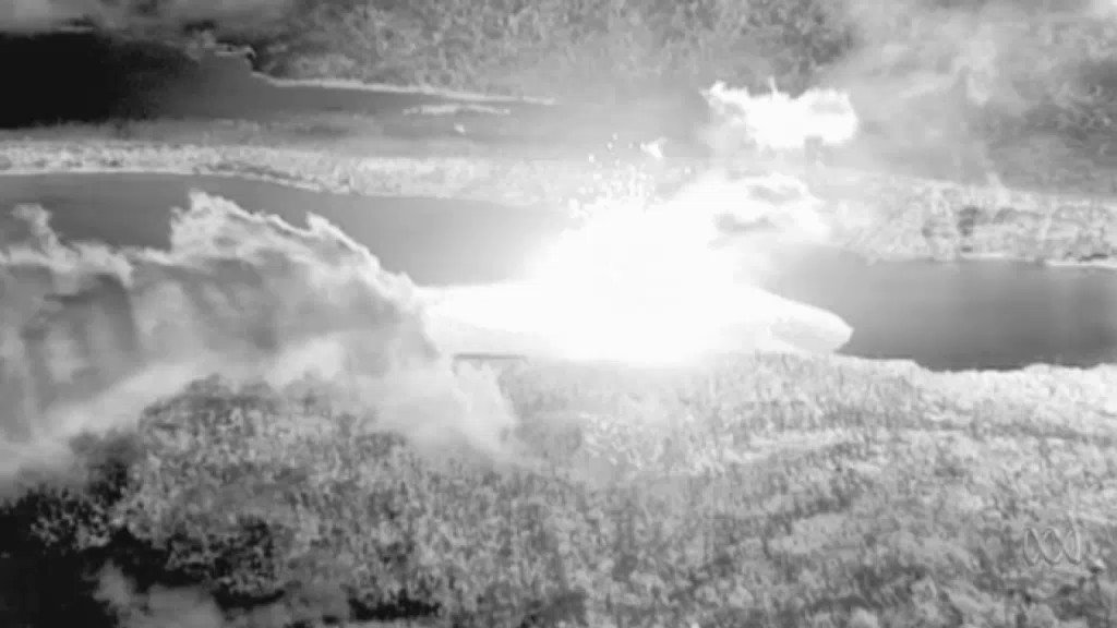
Infrared footage shows Vanuatu's Manaro volcano 
27 SEP 2017. Imagery taken during a New Zealand Defence Force aerial survey on September 27 showed huge columns of smoke, ash and volcanic rocks billowing from the crater of Manaro Voui volcano on Vanuatu's Ambae Island.

Some residents have left the island voluntarily. For them, it’s a waiting game to see whether the volcano erupts or returns to normal activity that’s not a threat. Officials say they have no real way of predicting what the volcano will do next and that evacuees will just have to wait it out.

Bule said the evacuation will be carried out by boat and continue through Oct. 6. He said residents will be moved onto nearby islands. Officials are setting up two sites on Pentecost Island, he said, where evacuees will be housed in government buildings or in temporary camp sites.

Ambae island has long been volcanically active. A previous eruption in 2005 forced about 3,300 people to temporarily leave their homes and relocate elsewhere on the island, but didn’t lead to an evacuation of the island itself.

Dickinson Tevi, a spokesman for the Vanuatu Red Cross Society, said the relief agency has been shipping water and shelter equipment to Ambae island.

“People are quite afraid with the sound of rumbling going on,” he said. “They are very uncertain and afraid.”

Bule said the government had allocated 200 million vatu ($1.9 million) toward the evacuation effort and was deploying 60 police officers to help people leave and to ensure there was no looting.

“We’ve prepared for cyclones by putting evacuation centers on the island but we are not ready for a volcanic eruption,” Bule said. “The government has to put a policy in place to cater for this in the future.”

This Tuesday, Sept. 26, 2017 photo provided by the New Zealand Defense Force, shows huge columns of smoke, ash and volcanic rocks billowing from the crater of an erupting volcano on Vanuatu’s Ambae Island. (New Zealand Defense Force via AP)

Vanuatu’s Meteorology and Geohazards Department has previously warned that people nearest to the volcano face the biggest risk from airborne rocks and volcanic gas and that acid rain could damage crops across a broader area.

Vanuatu is home to about 280,000 people and is prone to natural disasters, with a half-dozen active volcanoes as well as regular cyclones and earthquakes. It sits on the Pacific’s “Ring of Fire,” the arc of seismic faults around the Pacific Ocean where earthquakes and volcanoes are common.

Comment by M. Difato on September 21, 2017 at 4:17pm

Mexico suffers volcano eruption same day as deadly quake

 http://nypost.com/2017/09/20/volcano-also-erupted-in-mexico-during-...

 As if the deadly earthquake in Mexico weren’t enough, a volcano erupted amid the violent tremors.

Popocatepetl — about 45 miles southeast of quake-ravaged Mexico City and some 30 miles from the temblor’s epicenter — belched ash and gas as the 7.1-magnitude earthquake rocked the country’s central region.

The county’s volcano-monitoring system registered one explosion and 256 “low-intensity exhalations” between Tuesday and Wednesday mornings but said none of the activity can be attributed to the earthquake, according to Mexico’s National Center for Prevention of Disasters.

A church in Atzitzihuacan at the foot of the mountain collapsed during the quake and eruption, killing 15 worshippers as they celebrated Mass inside.

Pope Francis said he was praying for victims in the majority-Catholic country.

“In this moment of pain, I want to express my closeness and prayers to all the beloved Mexican people,” he said.

The 17,700-foot Popocatepetl has been particularly active this summer and also blew its top amid the Aug. 21 solar eclipse.

Comment by Scott on September 16, 2017 at 11:04pm

Geothermal Heat Forms Giant Holes in Glacier (September 4, 2017)

Over 400 meter (1312 feet) wide holes [seen above in view from aircraft] have formed in Vatnajökull, Iceland's largest glacier. This is near the Bárðarbunga area, which had a volcanic eruption between 2014 and 2015.

According to geologist Magnús Tumi Guðmundsson, the entire Bárðabunga landscape changed after the eruption, with increased geothermal heat that has melted away a hundred meters of thick, glacial ice, forming these calderas.

In fact, this marks the first time in hundreds or even thousands of years that the ground beneath the glacier can be seen.

Magnús Tumi says the area needs to be carefully watched in order to watch out for any more calderas that might trigger a glacial outburst flood.

http://icelandreview.com/news/2017/09/04/geothermal-heat-forms-gian...

http://www.ruv.is/frett/gat-i-gegnum-jokulinn

ZetaTalk Comment 4/17/2010: Iceland hosts many volcanoes as it sits on the boundary between the great Eurasian Plate and the great N American Plate, which are spreading apart. The tearing of the Atlantic Rift has been predicted by ourselves to occur long before the pole shift, and is already occurring.

Comment by M. Difato on September 5, 2017 at 8:08am

Fernandina Island Volcano Erupts in Galapagos

 http://www.thegeorgetowndish.com/thedish/fernandina-island-volcano-...

 Shortly after noon on September 4, 2017,  crew on Lindblad Expeditions/National Geographic ship Endeavor II observed a volcanic eruption at Fernandina Island in the Galapagos of Ecuador. The National Park of Galapagos was immeditaly notified.

It was confirmed as a new eruptive phase of Fernandina's La Cumbre volcano. 

After eight years of relative calm, this volcano began generating a column of water vapor and magmatic gases that were about four kilometers high.

Fernandina Island erupts September 4, 2017

~

Comment by Howard on August 9, 2017 at 3:32pm

2 Powerful Eruptions at Sheveluch and Bogoslov Volcanoes (Aug 8) 

A powerful eruption took place at Russia's Sheveluch volcano at 16:31 UTC on August 8, 2017. Ash cloud drifted SSE of the volcano. According to the Tokyo VAAC, ash cloud reached an altitude of 12.2 km (40 000 feet) above sea level.

At 21:20 UTC, the front of the 220 km (137 miles) long ash cloud was located about 360 km (224 miles) SSE of the volcano.

At 03:17 UTC on August 9, KVERT reported that explosive eruption of the volcano was ending, adding that a large ash cloud continues to drift from the volcano. The front was stretching out to the west and east. At 02:30 UTC, its western edge was about 490 km (305 miles) from the volcano, while the eastern edge was about 600 km (373 miles).

The explosive-extrusive eruption of the volcano continues, the agency said and warned that ash explosions up to 10 - 15 km (32 800 - 49 200 feet) a.s.l. could occur at any time. Ongoing activity could affect international and low-flying aircraft.

On August 7, another strong explosive eruption occurred at Bogoslov volcano, generating an ash plume that rose to estimated 32,000 ft (10 km) altitude.

The eruption began at about 18:00 UTC (10:00 AKDT local time) and was observed by a pilot. It lasted approximately 3 hours. The volcano's Aviation Color Code was again raised to RED.

Sources

https://www.volcanodiscovery.com/bogoslof/news/64618/Bogoslof-volca...

https://watchers.news/2017/08/07/bogoslof-eruption-august-7-2017/

https://watchers.news/2017/08/09/sheveluch-eruption-russia-august-2...

Comment by Howard on August 2, 2017 at 3:03pm

Powerful Eruption at Sumatra's Sinabung Volcano (Aug 2) 

Mt Sinabung blasted volcanic ash as high as 4.2 kilometers (2.6 miles) on Wednesday, one of its biggest eruptions in the past several months of high activity.

Isya Nurrahmat Dana, an official at a volcano monitoring post in North Sumatra province, said at least 19 eruptions followed by lava flows were recorded by midday Wednesday.

Hot ash tumbled down the mountain's slopes as far as 4.5 kilometers (2.8 miles) east and southeast into the Labortus River, inside the already devastated and evacuated zone around Sinabung.

National Disaster Mitigation Agency spokesman Sutopo Purwo Nugroho said thousands of people in 10 villages were directly affected by ash fall from the latest eruption.

He warned villagers to stay out of a danger zone that extends as far as 7 kilometers (4.4 miles) from the peak.

Sources

http://www.newsobserver.com/news/nation-world/world/article16491063...

https://www.volcanodiscovery.com/sinabung/news/64524/Sinabung-volca...

http://strangesounds.org/2017/08/volcanic-eruptions-august-2017-sin...

Comment by jorge namour on July 29, 2017 at 3:39pm

Earthquake activity in Katla volcano - ICELAND

July 23, 2017

http://www.jonfr.com/volcano/?p=6950

On Friday 22-July-2017 and on Saturday 23-July-2017 earthquake swarm activity took place inside Katla volcano caldera. Largest earthquake on Friday 22-July was magnitude 3,1 and on Saturday a magnitude 3,2 earthquake took place. Before and after the main earthquakes a swarm of smaller earthquakes took place.

Strong earthquake swarm on Reykjanes peninsula ICELAND
Posted on July 26, 2017
http://www.jonfr.com/volcano/?p=6956

Currently there is a strong earthquake swarm on the Reykjanes peninsula. Largest earthquake so far was a magnitude 4,0 with second largest earthquake having magnitude of 3,8. This earthquake swarm is currently ongoing. Over 150 earthquakes have been detected so far (this number is going to get obsolete soon).

Update 1 at 00:04 – 27-July-2017

Over 300 earthquakes have happened so far on the Reykjanes peninsula. Largest earthquake so far had the magnitude of 3,8 and second largest had the magnitude of 3,3.

Glacier flood confirmed from Mýrdalsjökull glacier ICELND

July 28, 2017
http://www.jonfr.com/volcano/?p=6977
It was confirmed at around 22:00 UTC that a small glacier flood has now started from Mýrdalsjökull glacier (Katla volcano). At the moment the glacier flood is small. It is unclear if this glacier flood is going to remain small and run it course as it is or if it is going to increase in next few hours.

Reports have been coming of strong sulphur smell in the area of Múlakvísl on Mýrdalssand area (desert area south of Mýrdalsjökull glacier).

Civil protection authority in Iceland have closed down few tourist roads and limited access to certain areas for time being due to this glacier flood. I strongly recommend that people follow those closers since change can happen in Katla volcano without warning and the closer people are to the volcano the less time they have to get away from it if an eruption starts.

Comment by M. Difato on July 9, 2017 at 6:40pm

Alaskan volcano erupts again, leading to aviation warning

 http://www.nbcmontana.com/news/national/alaskan-volcano-erupts-agai...

 Spewed an ash cloud up to 30,000 feet

An Alaskan volcano that has erupted several times since last year spewed an ash cloud up to 30,000 feet, leading to an aviation warning.

The Bogoslof volcano erupted Saturday (July 8), sending ash over the Aleutians Islands, the Alaska Volcano Observatory (AVO) said.

It "remains at a heightened state of unrest and in an unpredictable condition, and additional explosions producing high-altitude volcanic clouds could occur at any time," the observatory said.

The volcano sits under the flight path of many flights from Asia to North America and its ash cloud could adversely affect aircraft.

"Ash and aircraft do not mix, as volcanic ash is abrasive, melts at jet engine temperatures, and can cause engine failure," the United States Geological Survey says.

The aviation color code remains at red..."

SEARCH PS Ning or Zetatalk

 
Search:

This free script provided by
JavaScript Kit

Donate

Donate to support Pole Shift ning costs. Thank you!

© 2024   Created by 0nin2migqvl32.   Powered by

Badges  |  Report an Issue  |  Terms of Service