"We warned at the start of ZetaTalk, in 1995, thatunpredictable weather extremes, switching about from drought to deluge,would occur and increase on a lineal basis up until the pole shift. Where this occurred steadily, it has only recently become undeniable. ZetaTalk, and only ZetaTalk, warned of these weather changes, at that early date. Our early warnings spoke to the issue of global heating from the core outward, hardly Global Warming, a surface or atmospheric issue, but caused by consternation in the core. Affected by the approach of Planet X, which was by then starting to zoom rapidly toward the inner solar system for its periodic passage, the core was churning, melting the permafrost and glaciers and riling up volcanoes. When the passage did not occur as expected in 2003 because Planet X had stalled in the inner solar system, we explained the increasing weather irregularities in the context of the global wobble that had ensued - weather wobbles where the Earth is suddenly forced under air masses, churning them. This evolved by 2005 into a looping jet stream, loops breaking away and turning like a tornado to affect the air masses underneath. Meanwhile, on Planet Earth, droughts had become more intractable and deluges positively frightening, temperature swings bringing snow in summer in the tropics and searing heat in Artic regions, with the violence of storms increasing in number and ferocity."
The wobble seems to have changed, as the temperature in Europe suddenly plunged after being like an early Spring, Alaska has its coldest temps ever while the US and much of Canada is having an extremely mild winter. India went from fatal cold spell to balmy again. Has the Earth changed position vs a vs Planet X to cause this?[and from another]Bitter cold records broken in Alaska - all time coldest record nearly broken, but Murphy's Law intervenes[Jan 30]http://wattsupwiththat.com/2012/01/30/bitter-cold-records-broken-in-alaskaJim River, AK closed in on the all time record coldest temperature of -80°F set in 1971, which is not only the Alaska all-time record, but the record for the entire United States. Unfortunately, it seems the battery died in the weather station just at the critical moment. While the continental USA has a mild winter and has set a number of high temperature records in the last week and pundits ponder whether they will be blaming the dreaded "global warming" for those temperatures, Alaska and Canada have been suffering through some of the coldest temperatures on record during the last week.
There has been no change in the wobble pattern, the wobble has merely become more severe. Nancy noted a Figure 8 format when the Earth wobble first became noticeable, in early 2005, after Planet X moved into the inner solar system at the end of 2003. The Figure 8 shifted along to the east a bit on the globe between 2005 and 2009, (the last time Nancy took its measure) as Planet X came closer to the Earth, encountering the magnetic N Pole with a violent push earlier in the day. But the pattern of the Figure 8 remained essentially the same. So what changed recently that the weather patterns became noticeably different in late January, 2012?
The N Pole is pushed away when it comes over the horizon, when the noon Sun is centered over the Pacific. This regularly puts Alaska under colder air, with less sunlight, and thus the historically low temps there this January, 2012 as the wobble has gotten stronger. But by the time the Sun is positioned over India, the N Pole has swung during the Figure 8 so the globe tilts, and this tilt is visible in the weather maps from Asia. The tilt has forced the globe under the hot air closer to the Equator, warming the land along a discernable tilt demarcation line.
The next loop of the Figure 8 swings the globe so that the N Pole moves in the other direction, putting the globe again at a tilt but this time in the other direction. This tilt is discernable in weather maps of Europe, again along a diagonal line. Depending upon air pressure and temperature differences, the weather on either side of this diagonal line may be suddenly warm or suddenly cold. The tilt and diagonal line lingers to affect much of the US and Canada, but the Figure 8 changes at this point to be an up and down motion, pulling the geographic N Pole south so the US is experiencing a warmer than expected winter under a stronger Sun. Then the cycle repeats, with the magnetic N Pole of Earth pushed violently away again as the Sun is positioned over the Pacific.
Would the Zetas be able to let us know what is causing the early break-up of the Arctic Ice, the ice seems to have taken on a swirling pattern at the same time, would this be wobble related?[and from another]http://www.vancouversun.com/news/national/Canada+Arctic+cracks+spec... The ice in Canada’s western Arctic ripped open in a massive “fracturing event” this spring that spread like a wave across 1,000 kilometres of the Beaufort Sea. Huge leads of water – some more than 500 kilometres long and as much as 70 kilometres across – opened up from Alaska to Canada’s Arctic islands as the massive ice sheet cracked as it was pushed around by strong winds and currents. It took just seven days for the fractures to progress across the entire area from west to east.[and from another]http://earthobservatory.nasa.gov/IOTD/view.php?id=80752&src=iot... A high-pressure weather system was parked over the region, producing warmer temperatures and winds that flowed in a southwesterly direction. That fueled the Beaufort Gyre, a wind-driven ocean current that flows clockwise. The gyre was the key force pulling pieces of ice west past Point Barrow, the northern nub of Alaska that protrudes into the Beaufort Sea.
The Figure 8 formed by the N Pole during the daily Earth wobble has shifted somewhat to the East, due to Planet X positioned more to the right of the Earth during its approach. This was anticipated, and well described in ZetaTalk, the Earth crowding to the left in the cup to escape the approach of Planet X, so the angle between these two planets would change slightly. This shift of the Figure 8 to the East is due to the push against the Earth’s magnetic N Pole occurring sooner each day than prior. Thus instead of occurring when the Sun is high over the Pacific, over New Zealand, it is now occurring when the Sun is high over Alaska. All the wobble points have shifted eastward accordingly.
This has brought a lingering Winter to the western US, and a changed sloshing pattern to the Arctic waters. Instead of Pacific waters being pushed through the Bering Straits into the Arctic when the polar push occurs, the wobble is swinging the Arctic to the right, and then later to the left, creating a circular motion in the waters trapped in the Arctic. Since the Earth rotates counterclockwise, the motion also takes this path. This is yet another piece of evidence that the establishment is hard pressed to explain. They are attempting to ascribe this to high pressure and wind, all of which are not new to the Arctic, but this circular early breakup of ice in the Arctic is new.
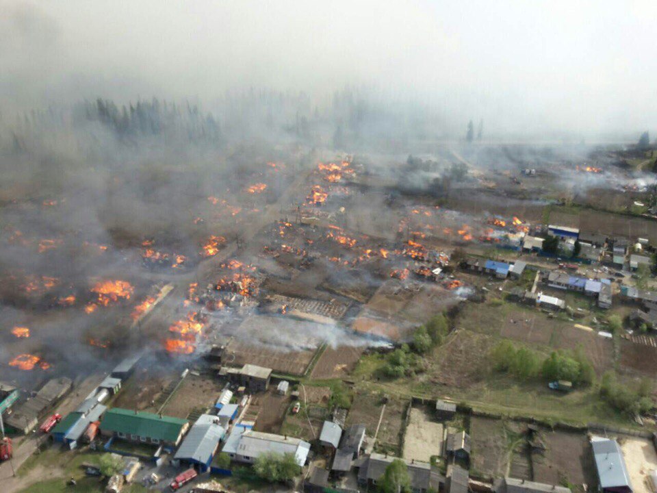
Apocalyptical wildfire burns down hundreds of homes in Siberia – State of emergency declared
Three people have been killed and hundred of homes burned down as Russia declares a state of emergency in the Krasnoyarsk region after an apocalyptical inferno engulfed Siberia on May 24, 2017.
More than 340 people are now homeless, among others 47 children. State of emergency has been declared.
3 people died and more than 170 houses burned down as an apocalyptical dry grass fires swept across several hundreds of hectares of prairies in the Krasnoyarsk region of Siberia.
Mainly two cities have been severely affected: Lesosibirsk and Kansk.
Deadly wildfires swept across Siberia burning down 200 homes in villages on May 24 2017. A house burning during apocalyptical wildfires in Siberia on May 24 2017.
The uncontrollable fire killed two people in Kansk and more than 40 houses burned down.
180 houses burned down in Siberia villages in May 2017. Officials are investigating the source of the furious fire.
Another one died in one of the horticultural cooperatives in the city of Bratsk.
Desolation after a complete part of a city has disappeard, burned down by an apocalyptical fire in Siberia. Een churches didn’t resist the Siberian inferno.
In Lesosibirsk, more than 40 homes burned down and the threat of the spread of fire is maintained.
Luckily onl 3 people died in the blaze. A cow in the Siberian city destroyed by the flames.
State of emergency has been declared in both cities.
About 400 people are looking for another home after the destruction of their homes in Siberia. Happy to be ae at home! Have a prayer for them!
In overall more than 171 houses have burned down during this intense blaze. Have a prayer for them!
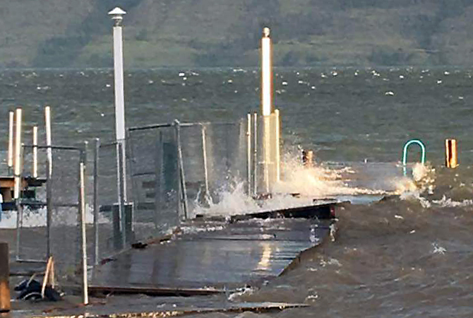
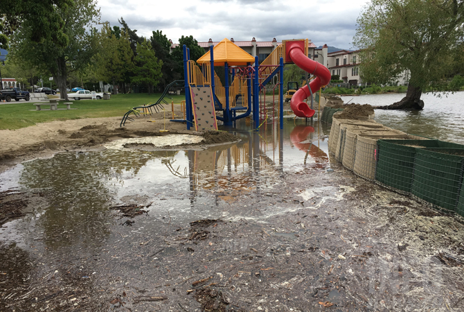
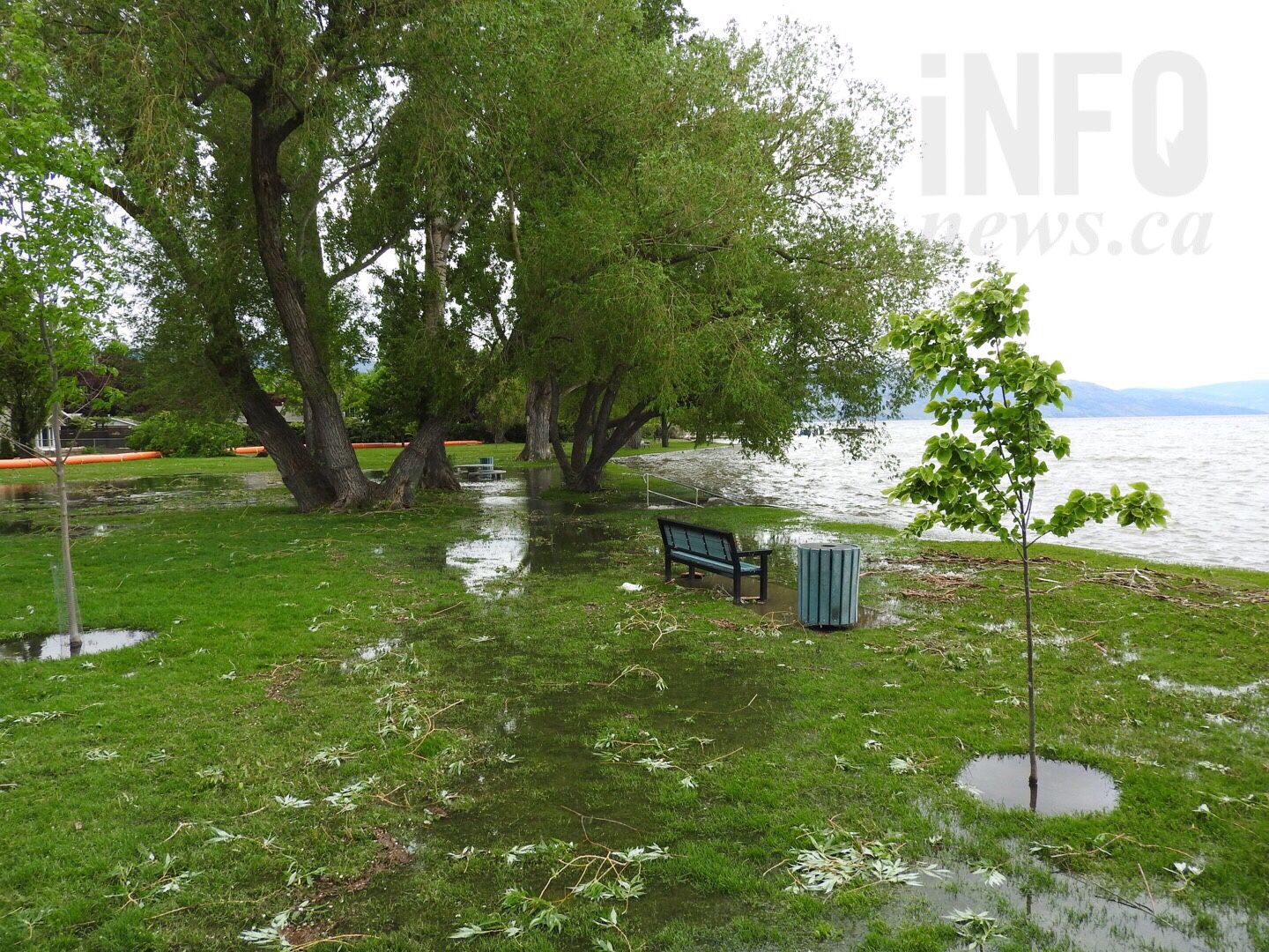
FLOOD WATCH 2017: iN PHOTOS: Last night's winds were enough to cause permanent changes to shoreline in Central Okanagan
KELOWNA - The high winds produced by last night's storm that blew through the Interior left serious damage behind in the Central Okanagan.
Environment Canada predicted the northeasterly wind could reach 70 km/h overnight, and with the lake level already well above full pool, waves were expected to crest most docks. The forecasters were not far off. The top wind gust recorded in Kelowna was 74 km/h.
It was enough to down branches, break up docks and knock out power to hundreds of Southern Interior residents.
"High winds on overfilled lakes last night caused localized flooding for residences in low lying areas on Central Okanagan lakes," Central Okanagan Emergency Operations officials from say in a media release. "Emergency crews are out today clearing windfall from streams, inspecting and assessing flood protection measures and infrastructure to determine the top priorities for further action. Residents should be aware of the risk of falling trees within saturated ground conditions near lakes and creeks."
It also brought tonnes of sand on shore, creating beaches where they didn't exist before.
Branches in City Park in Kelowna were knocked down during the wind storm last night.
Okanagan Lake rose 4.5 centimetres overnight to a level of 342.95 metres, only five centimetres below the highest level of 343 metres recorded in 1948.
"A break in the weather today offers residents a chance to fortify flood protection," emergency officials say. "With lakes approaching historic volumes, the high water levels are expected to remain well into July. Residents are urged to keep protection in place for the foreseeable future."
We welcome your comments and opinions on our stories but play nice. We won't censor or delete comments unless they contain off-topic statements or links, unnecessary vulgarity, false facts, spam or obviously fake profiles. If you have any concerns about what you see in comments, email the editor in the link above.
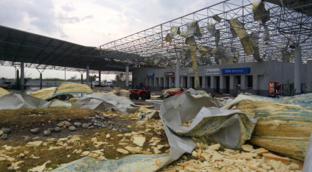
Destructive tornado hits Nuevo Laredo in Mexico – US border closed down indefinitely
A destructive tornado hit Nuevo Laredo, a city in Mexico, on the border with Texas (US) on May 21, 2017.
The Mexico-US border has been closed indefinitely.
And here from inside the damaging twister:
The unexpected tornado destroyed many buildings, among others the custom facilities of International Bridge 3 “Las Americas” thus closing it indefinitely until complete rehabilitation.
Border between USA and Mexico closed after tornado destroys custom facilities in Nuevo Laredo (Mexico). The unexpected tornado also damaged trucks and electricity poles at the border between Texas and Mexico. All custom facilities have been destroyed within minutes in Nuevo Laredo.
Moreover, the heavy traffic has been suspended as the wind overturned trucks, damaged communication antennas and electric power poles cutting power in hundreds of households and companies.
Targeted tornadoes? A new way to limit immigration in the US? Even the biggest trucks didn’t resist the strong tornado in Nuevo Laredo. Electricity poles and power supply were caught off after the tornado in Nuevo Laredo.
Costs and time for reparation have not been communicated, but emergency troops are on site to estimate damages.
Are targeted tornadoes a new way to limit illegal immigration in the US?
Arctic stronghold of world’s seeds flooded after permafrost melts
No seeds were lost but the ability of the rock vault to provide failsafe protection against all disasters is now threatened by climate change
It was designed as an impregnable deep-freeze to protect the world’s most precious seeds from any global disaster and ensure humanity’s food supply forever. But the Global Seed Vault, buried in a mountain deep inside the Arctic circle, has been breached after global warming produced extraordinary temperatures over the winter, sending meltwater gushing into the entrance tunnel.
The vault is on the Norwegian island of Spitsbergen and contains almost a million packets of seeds, each a variety of an important food crop. When it was opened in 2008, the deep permafrost through which the vault was sunk was expected to provide “failsafe” protection against “the challenge of natural or man-made disasters”.
But soaring temperatures in the Arctic at the end of the world’s hottest ever recorded year led to melting and heavy rain, when light snow should have been falling. “It was not in our plans to think that the permafrost would not be there and that it would experience extreme weather like that,” said Hege Njaa Aschim, from the Norwegian government, which owns the vault.
“A lot of water went into the start of the tunnel and then it froze to ice, so it was like a glacier when you went in,” she told the Guardian. Fortunately, the meltwater did not reach the vault itself, the ice has been hacked out, and the precious seeds remain safe for now at the required storage temperature of -18C.
But the breach has questioned the ability of the vault to survive as a lifeline for humanity if catastrophe strikes. “It was supposed to [operate] without the help of humans, but now we are watching the seed vault 24 hours a day,” Aschim said. “We must see what we can do to minimise all the risks and make sure the seed bank can take care of itself.”
The vault’s managers are now waiting to see if the extreme heat of this winter was a one-off or will be repeated or even exceeded as climate change heats the planet. The end of 2016 saw average temperatures over 7C above normal on Spitsbergen, pushing the permafrost above melting point.
“The question is whether this is just happening now, or will it escalate?” said Aschim. The Svalbard archipelago, of which Spitsbergen is part, has warmed rapidly in recent decades, according to Ketil Isaksen, from Norway’s Meteorological Institute.
“The Arctic and especially Svalbard warms up faster than the rest of the world. The climate is changing dramatically and we are all amazed at how quickly it is going,” Isaksen told Norwegian newspaper Dagbladet.
Oh buoy! Southern Hemisphere's largest wave recorded by Kiwi scientists
A Kiwi buoy recorded the largest ever wave in the Southern Hemisphere on Saturday. (file photo)
A giant wave south of New Zealand earlier this weekend was the biggest ever recorded by a buoy in the Southern Hemisphere - and scientists expect even higher waves to follow over winter.
The 19.4-metre wave - higher than a five-storey building - was captured by a newly-deployed buoy in the Southern Ocean on Saturday morning.
Waves in the area are among the biggest in the world, and researchers say this one "isn't as big as it gets".
The data will help the NZDF better understand conditions in the Southern Ocean to design its future vessels.
"There's a possibility we'll get something even bigger, and we are starting to get towards the biggest waves ever measured anywhere," says David Johnson, the technical director of MetOcean, which partnered with the New Zealand Defence Force to deploy the buoy in February.
"The main excitement is, basically, we're measuring something in a place that's never really been measured before, and we're capturing some quite exceptionally large waves."
Source: METOCEAN
Saturday's wave was some way off the world's highest individual wave: in 2013, British scientists one about 27 metres high in waters northwest of Scotland.
The New Zealand buoy is the southernmost that's ever been deployed, and if one went further south, it would likely capture even bigger waves, Johnson says.
Before the buoy, Kiwi scientists relied on satellite data for estimates of "significant wave height" - a rather technical average across several waves, on which "biggest wave" records are usually based.
The buoy offers a greater level of accuracy of data about individual waves, and helps build a sharper picture of conditions in the Southern Ocean.
Its primary purpose is to collect information that helps NZDF design its future vessels with a greater understanding of conditions in the Southern Ocean.
"At the moment, when they're designing these vessels, there's very little understanding of the sea states they're going ot have to deal with. Obviously for safety of personnel and what-not, that's extremely important," Johnson said.
It also provides for scientists modelling and measuring waves, both in New Zealand and around the world.
The buoy runs on solar power, and a lack of sunlight in the Southern Ocean over winter may thwart its ability to record wave heights, but there's "an outside chance" that it may do, Johnson says.
Comment by Gerard Zwaan on May 21, 2017 at 10:55am
Deadly heatwave in India claims 161 lives as temperatures approach 50 Celsius (122 Fahrenheit ) with no end in sight
Photo reuters.com Telangana had been burning over 40 degree Celsius for some days. According to MeT department the situation will prevail for at least one more week. At least 161 people in Telangana have died due to heat stroke during this summer. Meanwhile the weather department has issued fresh warning predicting heatwave conditions at isolated places in all the districts of Telangana for next 5 days. Bhadrachalam, Ramagundam and Nalgonda were the hottest places in the state with each recording maximum temperature of 46 degrees Celsius, while the maximum number of deaths were reported from Khammam and Karimanagr districts of the state. On Friday the highest temperature recorded at Nalgonda was 46 degrees, while Ramagudem recorded 45.8, Khammam 45.2, Bhadrachalam 45.4, Nizamabad 44.4, Nizamabad 44.9, Adilabad 44.8, Hanamkonda 44.5. Hyderabad too recorded a temperature of 42.5 degrees Celsius. Government of Telangana has formed a three-member committee in all mandals consisting the local Sub Inspector, a civil surgeon and tahsilda to determine and verify the sunstroke death. Government of Telangana is providing Rs 50,000 as compensation to the victims' families under its Apathbandu scheme. Neighbouring Andhra Pradesh is also witnessing abnormal hike in temperature. Yesterday Bapatla of Guntur recorded a maximum temperature of 46.2 degrees, while Nandigama, Ongole, Janagamaheshwarapuram recorded temperature over 45. IMD has issued a 5 day heatwave warning for districts of coastal Andhra Pradesh and Rayaleseema region of the state. Meanwhile Andhra Pradesh govternment has asked people to remain indoors till evenings after getting the heatwave alerts.
A massive flooding is affecting Russia's Tyumen region in Siberia since May 11, 2017, after a large discharge of water from the reservoir in Kazakhstan. Tyumen governor said the actual release was much higher than Kazakstan officials claim. A state of emergency is in place in the city of Ishim and three municipalities of the Tyumen region.
The governor said preparations in Tyumen began in March due to expected snowmelt, but the floods that hit the region this year have a different source. "It is the water that came from the territory of the Republic of Kazakhstan, where there was a release or a large volume of water from Sergeevskoye reservoir," he said. He noted that they were informed about the planned release, but the information proved to be unreliable.
River Ishim, which runs through the city of Ishim, received a huge volume of water within three days and city's levees broke.
Tyumen GU Ministry of Emergency Situations said that more than 4 000 houses were flooded in Ishim and Ishimsky district. The government opened 13 evacuation centers for about 2 000 people.
Island of Lamèque cut off from mainland following major thunderstorm in Acadian Peninsula
At the storm's peak, more than 7,000 NB Power customers without power
Power poles were knocked down during a huge thunderstorm in the Acadian Peninsula Thursday night.
More than 4,000 NB Power customers are still without power this morning after a violent thunderstorm ripped through the Acadian Peninsula on Thursday night.
At its peak, close to 7,000 NB Power customers in some regions of the province were without power.
Heavy winds split power poles in half and tore large roofing tiles off a store in downtown Caraquet, one of the areas that saw the most impact. Lamèque and Shippagan were also hit hard by the storm.
Robert Duguay, spokesperson with New Brunswick Emergency Measures Organization [NBEMO], said a bridge between the town of Shippagan to Lamèque Island has been closed after several electric poles fell onto the bridge. He said the Canadian Coast Guard also had to rescue a boat that was stranded in the water during the storm.
Duguay said Lamèque, located in the northern part of the province, is currently cut off from the mainland and will be without power for the next several hours.
Repair work to be complex
"We're talking about electric poles that are located in very awkward situations, very difficult locations on the bridge, so that could require more time," he said. "That bridge is directly to the wind and got hit very hard."
The road was secured by NB Power crews on Thursday night, but the bridge will remain closed to traffic and pedestrians. The only access will be for emergency vehicles. The bridge is expected to open again by Saturday morning.
Duguay said the repair work will be complex, as both transmission and distribution lines have been damaged.
"All the poles fell down and fell directly in the middle of the road, which made the road very dangerous last night," he said.
Duguay said Thursday night's storm was a replica of the January ice storm that hit the area earlier this year, but the impact is limited to a very small area and the storm was brief.
"The situation is now stable," he said. "It was a very quick … major storm that hit very hard on the Acadian Peninsula."
'It was a very sudden and intense thunder and lightning storm.'- Marie Andrée Bolduc
He said there have been no reports of injuries or fatalities and that NBEMO has activated its Regional Operation Emergency Centre within the Peninsula.
Air patrol will also be used Friday morning to help with damage assessment, as crews work to restore power and replace poles and equipment as necessary.
Marie Andrée Bolduc, spokesperson with NB Power, said up to 20 poles fell following Thursday night's thunderstorm.
"It was a very sudden and intense thunder and lightning storm," said Bolduc.
She said NB Power will assess what needs to be done in the area on Friday morning and that additional crews from across the province will be helping restore power lines, as well as providing replacement equipment, such as more poles.
"All hands are on deck, but the assessment and repairs will continue throughout the day," she said.
Estimated restoration times will be posted on the NB Power website as they become available.
Residents are also advised to stay clear of downed lines, trees and equipment for safety reasons. Residents are asked to drive slowly in affected areas and watch for crews working to restore power near the roads.
Jamaica Battered! Heavy rains destroy roads, bridges; flood communities
This is what is left of the Guy's Hill main road after flood waters converted it into a river yesterday. (Photo: Garfield Robinson)
TheGovernment says it is too early to give an estimate, but the cost to the country from relentless rains over the past three days could be staggering, considering that the damage from showers just a few weeks ago was preliminarily put at close to $500 million.It was only on Monday that the local government ministry allocated $175 million in emergency funds to six parishes to help restore access to communities which were cut off as a result of those rains.
And now, three days of heavy rains associated with a trough across the central Caribbean have again wreaked havoc on the island's infrastructure, dumping up to a month's volume of rainfall on some areas, washing away bridges, tearing up roads, forcing rivers to burst their banks, and leaving a number of Jamaicans marooned.
While there were no reports of deaths up to yesterday evening, more than 30 people have so far had to be rescued by the Jamaica Defence Force and the Jamaica Fire Brigade.
The Office of Disaster Preparedness and Emergency Management (ODPEM) says the community of Aenon Town in Clarendon — the hardest hit parish — was inundated by up to 17 feet of raging waters.
Flood waters also converted the Guy's Hill main road in St Catherine into a river.
Yesterday, at a Jamaica House press conference, Acting Prime Minister Dr Horace Chang said St Thomas, Kingston, St Andrew, St Catherine, Manchester, parts of Westmoreland, St Mary, Portland, and sections of northern St Ann were also severely impacted.
“The volume of rainfall over the last 24 hours (between Monday and Tuesday), in particular, has caused severe infrastructural and agricultural damage, dislocation, and major inconvenience, especially for students who are sitting secondary exit exams. The reports have been coming in fast from Westmoreland to St Thomas and Trelawny to Portland of inundated roads and farmlands, lost crops, flooded communities, breakaways and landslides, and citizens who have been marooned or were in distress,” Dr Chang stated.
In the meantime, Local Government Minister Desmond McKenzie said the parishes of St James, Trelawny, and Hanover were the only ones spared the wrath of the relentless rains.
The National Works Agency (NWA) reported extensive flooding in southern Clarendon in areas such as Sedge Pond, Water Lane, Foga Road, McGilchrist Pen, and Four Paths. Also, the Green River Bridge, which gives access to Frankfield, as well as the Dam Head Bridge, have been washed away, the authorities reported. Major landslides have occurred in communities in the parish, blocking roads, such as that which joins Danks to Croft's Hill. A long list of other roads have all been impacted by landslides.
With the Bog Walk Gorge flooded, the NWA has asked that motorists either go through Sligoville or use the North-South link of Highway 2000, as the other alternative route, through Barry, was impassable.
In rural St Andrew, there were two massive landslides, at Flamstead and Milepost 16 in Newcastle, while in Mammee Bay, St Ann, and parts of Mandeville, Manchester, there were reports of flooding. Westmoreland, though not as severely impacted, has also experienced flooding in Little London and a number of other communities.


 Deadly wildfires swept across Siberia burning down 200 homes in villages on May 24 2017.
 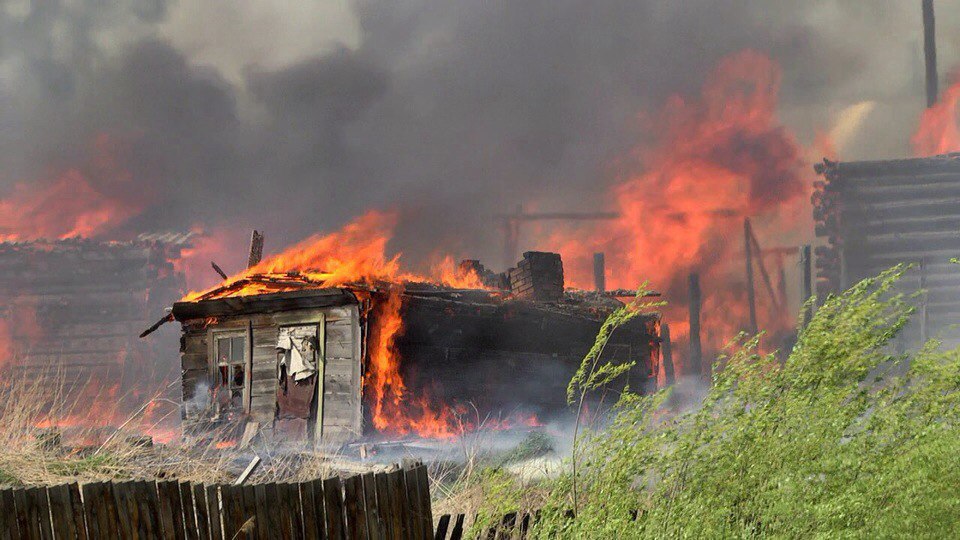 A house burning during apocalyptical wildfires in Siberia on May 24 2017.
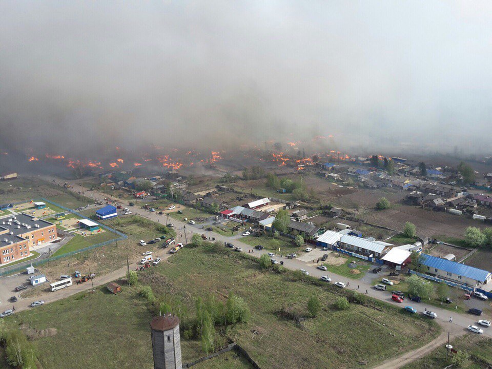 180 houses burned down in Siberia villages in May 2017.
  Officials are investigating the source of the furious fire.
 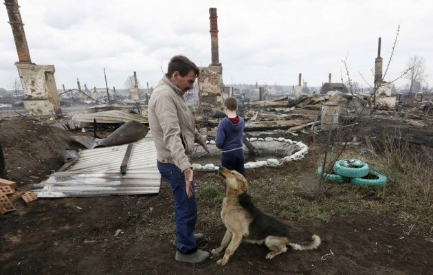 Desolation after a complete part of a city has disappeard, burned down by an apocalyptical fire in Siberia.
  Een churches didn’t resist the Siberian inferno.
 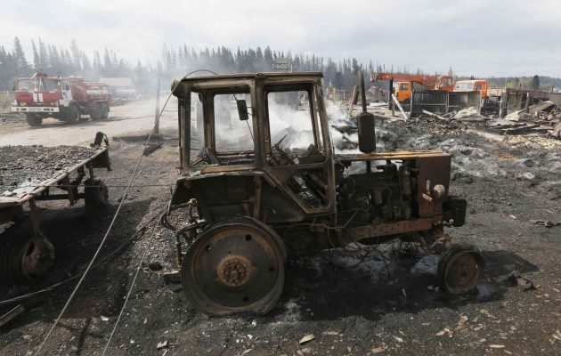 Luckily onl 3 people died in the blaze.
 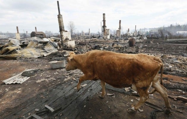 A cow in the Siberian city destroyed by the flames.
 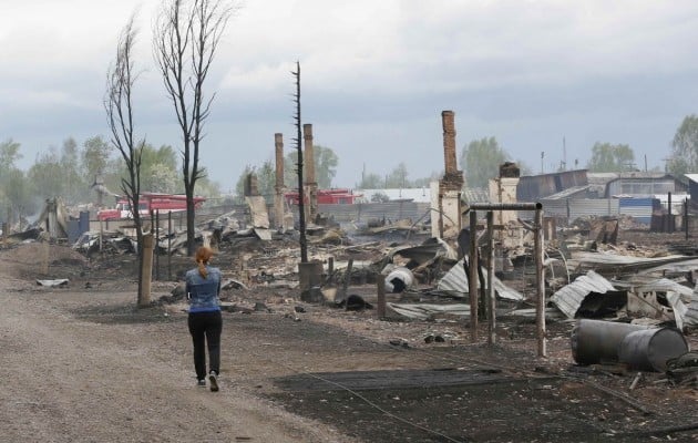 About 400 people are looking for another home after the destruction of their homes in Siberia.
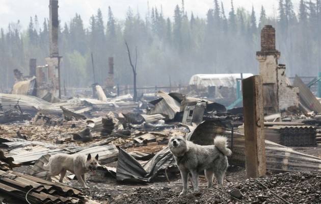 Happy to be ae at home! Have a prayer for them!
 Border between USA and Mexico closed after tornado destroys custom facilities in Nuevo Laredo (Mexico).
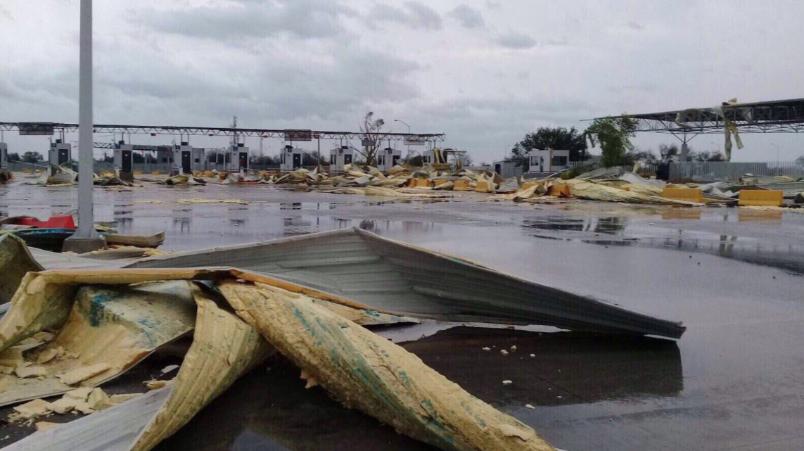 The unexpected tornado also damaged trucks and electricity poles at the border between Texas and Mexico.
 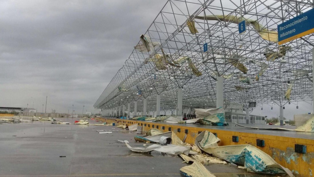 All custom facilities have been destroyed within minutes in Nuevo Laredo.
 Targeted tornadoes? A new way to limit immigration in the US?
  Even the biggest trucks didn’t resist the strong tornado in Nuevo Laredo.
  Electricity poles and power supply were caught off after the tornado in Nuevo Laredo.
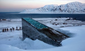


You need to be a member of Earth Changes and the Pole Shift to add comments!
Join Earth Changes and the Pole Shift