"We warned at the start of ZetaTalk, in 1995, thatunpredictable weather extremes, switching about from drought to deluge,would occur and increase on a lineal basis up until the pole shift. Where this occurred steadily, it has only recently become undeniable. ZetaTalk, and only ZetaTalk, warned of these weather changes, at that early date. Our early warnings spoke to the issue of global heating from the core outward, hardly Global Warming, a surface or atmospheric issue, but caused by consternation in the core. Affected by the approach of Planet X, which was by then starting to zoom rapidly toward the inner solar system for its periodic passage, the core was churning, melting the permafrost and glaciers and riling up volcanoes. When the passage did not occur as expected in 2003 because Planet X had stalled in the inner solar system, we explained the increasing weather irregularities in the context of the global wobble that had ensued - weather wobbles where the Earth is suddenly forced under air masses, churning them. This evolved by 2005 into a looping jet stream, loops breaking away and turning like a tornado to affect the air masses underneath. Meanwhile, on Planet Earth, droughts had become more intractable and deluges positively frightening, temperature swings bringing snow in summer in the tropics and searing heat in Artic regions, with the violence of storms increasing in number and ferocity."
The wobble seems to have changed, as the temperature in Europe suddenly plunged after being like an early Spring, Alaska has its coldest temps ever while the US and much of Canada is having an extremely mild winter. India went from fatal cold spell to balmy again. Has the Earth changed position vs a vs Planet X to cause this?[and from another]Bitter cold records broken in Alaska - all time coldest record nearly broken, but Murphy's Law intervenes[Jan 30]http://wattsupwiththat.com/2012/01/30/bitter-cold-records-broken-in-alaskaJim River, AK closed in on the all time record coldest temperature of -80°F set in 1971, which is not only the Alaska all-time record, but the record for the entire United States. Unfortunately, it seems the battery died in the weather station just at the critical moment. While the continental USA has a mild winter and has set a number of high temperature records in the last week and pundits ponder whether they will be blaming the dreaded "global warming" for those temperatures, Alaska and Canada have been suffering through some of the coldest temperatures on record during the last week.
There has been no change in the wobble pattern, the wobble has merely become more severe. Nancy noted a Figure 8 format when the Earth wobble first became noticeable, in early 2005, after Planet X moved into the inner solar system at the end of 2003. The Figure 8 shifted along to the east a bit on the globe between 2005 and 2009, (the last time Nancy took its measure) as Planet X came closer to the Earth, encountering the magnetic N Pole with a violent push earlier in the day. But the pattern of the Figure 8 remained essentially the same. So what changed recently that the weather patterns became noticeably different in late January, 2012?
The N Pole is pushed away when it comes over the horizon, when the noon Sun is centered over the Pacific. This regularly puts Alaska under colder air, with less sunlight, and thus the historically low temps there this January, 2012 as the wobble has gotten stronger. But by the time the Sun is positioned over India, the N Pole has swung during the Figure 8 so the globe tilts, and this tilt is visible in the weather maps from Asia. The tilt has forced the globe under the hot air closer to the Equator, warming the land along a discernable tilt demarcation line.
The next loop of the Figure 8 swings the globe so that the N Pole moves in the other direction, putting the globe again at a tilt but this time in the other direction. This tilt is discernable in weather maps of Europe, again along a diagonal line. Depending upon air pressure and temperature differences, the weather on either side of this diagonal line may be suddenly warm or suddenly cold. The tilt and diagonal line lingers to affect much of the US and Canada, but the Figure 8 changes at this point to be an up and down motion, pulling the geographic N Pole south so the US is experiencing a warmer than expected winter under a stronger Sun. Then the cycle repeats, with the magnetic N Pole of Earth pushed violently away again as the Sun is positioned over the Pacific.
Would the Zetas be able to let us know what is causing the early break-up of the Arctic Ice, the ice seems to have taken on a swirling pattern at the same time, would this be wobble related?[and from another]http://www.vancouversun.com/news/national/Canada+Arctic+cracks+spec... The ice in Canada’s western Arctic ripped open in a massive “fracturing event” this spring that spread like a wave across 1,000 kilometres of the Beaufort Sea. Huge leads of water – some more than 500 kilometres long and as much as 70 kilometres across – opened up from Alaska to Canada’s Arctic islands as the massive ice sheet cracked as it was pushed around by strong winds and currents. It took just seven days for the fractures to progress across the entire area from west to east.[and from another]http://earthobservatory.nasa.gov/IOTD/view.php?id=80752&src=iot... A high-pressure weather system was parked over the region, producing warmer temperatures and winds that flowed in a southwesterly direction. That fueled the Beaufort Gyre, a wind-driven ocean current that flows clockwise. The gyre was the key force pulling pieces of ice west past Point Barrow, the northern nub of Alaska that protrudes into the Beaufort Sea.
The Figure 8 formed by the N Pole during the daily Earth wobble has shifted somewhat to the East, due to Planet X positioned more to the right of the Earth during its approach. This was anticipated, and well described in ZetaTalk, the Earth crowding to the left in the cup to escape the approach of Planet X, so the angle between these two planets would change slightly. This shift of the Figure 8 to the East is due to the push against the Earth’s magnetic N Pole occurring sooner each day than prior. Thus instead of occurring when the Sun is high over the Pacific, over New Zealand, it is now occurring when the Sun is high over Alaska. All the wobble points have shifted eastward accordingly.
This has brought a lingering Winter to the western US, and a changed sloshing pattern to the Arctic waters. Instead of Pacific waters being pushed through the Bering Straits into the Arctic when the polar push occurs, the wobble is swinging the Arctic to the right, and then later to the left, creating a circular motion in the waters trapped in the Arctic. Since the Earth rotates counterclockwise, the motion also takes this path. This is yet another piece of evidence that the establishment is hard pressed to explain. They are attempting to ascribe this to high pressure and wind, all of which are not new to the Arctic, but this circular early breakup of ice in the Arctic is new.
Mass evacuations as wildfire threatens Colorado City
Firefighters are battling to contain a raging wildfire just outside Boulder, Colorado which has already forced the evacuation of more than 1,000 homes.
The fire broke out overnight and quickly expanded to cover 62 acres, according to the Boulder Office of Emergency Management (OEM). The blaze lies just west of the city of Boulder.
Authorities are struggling to contain the fire and the Denver Post reports that the flames is moving in a southerly direction towards downtown Boulder.
“That is a major concern,” Gabi Boerkircher of the Boulder Office of Emergency Management said. “It looks like it’s going to be very hot and very dry, and potential winds up to 20 mph. Which is not good.”
The office says it has multiple aircraft dropping water and slurry on the inferno. The Denver Channel reports that the blaze is “zero percent contained.”
A further 3,700 homes have been placed on evacuation notice and people have been told to prepare to leave. Large and small animals are also being evacuated to sites away from the path of the wildfire.
High temperatures, low humidity, and a significant breeze mean conditions are perfect for the fire to spread.
It’s not clear yet what sparked the fire. Multiple fire agencies are responding to the blaze and numerous roads have been closed as a result of the fire. There have been no reports yet of damage to homes or other buildings.
17 March, 2017. This year's wet season brings significant flooding to the most densely populated area of the country
Flooding in Namibia's Cuvelai-Etosha catchment area has reached alarming levels in recent weeks, with residents being warned to take the necessary precautions in expectation of the worst possible floods experienced in the region in living memory.
This is according to the Ministry of Agriculture, Water and Forestry; the disaster risk-management division in the prime minister's office; and the Namibia meteorological services.
In a joint statement, the authorities warned that the magnitude of flooding expected in the northern central regions is likely to surpass that of 2011, which saw the highest level of flooding in Namibia's recent history. "The 2017 floods are predicted to become even higher if good rains continue, as they are both in the headwaters of the Cuvelai catchments in southern Angola and in the northern border areas of Namibia within these catchments," the statement said.
The situation is predicted to be made worse by the opening of the sluice gates of the Gove Dam. Water from the dam is expected to flood the Kunene River, which in turn will flood parts of southern Angola and northern Namibia.
Erratic rainfall
Efundja, the annual seasonal flooding of the northern parts of the country, often causes not only damage to infrastructure but also loss of life. The rains that cause these floods fall in Angola, then flow into Namibia's Cuvelai basin and end up filling the flood plains there.
The basin is characterised by an interconnected system of shallow water courses, called oshanas, which are the "life-support system" for the most densely populated area in the country. They are easily prone to flooding through excessive rain or controlled release from dams. Water levels in the oshanas in the Omusati region have been rising since last week, an indication that more water from Angola has been flowing into the country.
Namibia is considered to be one of the most vulnerable countries to the effects of climate change in sub-Saharan Africa. Dry land, a hot and dry climate and erratic rainfall patterns, have traditionally exposed the country to recurrent droughts and wild fires. In Namibia's interior, surface water is available only in the summer months when rivers are in flood after exceptional rainfalls. Luckily, boreholes can be used in about 80 percent of the country. Source: aljazeera.com
Dramatic footage shows young woman caked in brown sludge fighting to escape being swept away in Peru mudslide
Woman caked in mud spotted battling to survive as she clung on to flood debris
At one point she is dragged under pallets and pulled towards a rampaging river
But incredibly, she claws her way to safety by stepping across planks of wood
Dramatic escape filmed in flood-hit Punta Hermosa, south of Peru's capital Lima
This is the dramatic moment a young woman caked in brown sludge fought to escape being swept away in a devastating mudslide in Peru.
Footage shows the woman battling to survive as a raging torrent of flood water thick with debris ripped through a valley in the district of Punta Hermosa, south of captial city Lima.
Terrified onlookers shouted to try to get her attention but were powerless to intervene as she was carried out towards the heaving brown rapids.
The shocking video emerged after some of the the heaviest rains and hottest temperatures in two decades have battered Peru over the past month as weather linked to El Nino caused flooding and landslides that blocked the country's central highway and forced hundreds from their homes.
Dramatic footage shows a young woman caked in brown sludge trying desperately to escape being swept away in a devastating mudslide in Peru
At one point in the clip, the woman waves to acknowledge she is safe only to be dragged back under one of dozens of wooden pallets swirling in the mudslide.
A man filming shouts 'somebody's down there' to rescuers after losing sight of the woman.
But incredibly, she avoids being dragged under or crushed and reappears, desperately clawing her way out of the water before stepping over floating planks of wood to the shore.
As she reaches the banks of the river, the terrified woman collapses to the ground before rescuers rush in to help her.
While the woman is dragged to safety, farm animals are also seen among the debris and torrents of mud, including a cow and what appears to be a piglet.
It is not known when exactly the video was captured.
It comes after a separate video emerged showing the Peruvian army dramatically rescuing stranded schoolchildren with a helicopter.
A video shows the moment the youngsters were pulled from the water by troops in an Mi-171 chopper.
The army at first rescued 72 people in the district of Pacora, among them 35 children who lived in the villages of La Junta Santa Isabel and Senor de Luren.
In total, over the course of various missions, more than 200 people - 123 of them children - had to be rescued after they became cut off from dry land.
In the video an army officer can be seen up to his waist in water, carrying a little boy over his shoulders.
He can be seen struggling towards the waiting helicopter, which hovers just over the dirty water.
Other soldiers can be seen helping the youngsters get into the helicopter which later flew them to safety.
The Peruvian Ministry of Defence confirmed they had rescued 210 people who had been isolated in their villages after La Leche river overflowed.
It comes after a separate video emerged showing the Peruvian army dramatically rescuing stranded schoolchildren with a helicopter
Eight villages were cut off and more than 30 houses collapsed due to the extreme weather conditions.
The flood was caused by heavy rains over just a few hours in the region of Lambayeque, north-western Peru.
The Ministry of Defence said the remainder were saved from the neighbouring district of Jayaca.
The government department shared a video of the dramatic rescue effort on social media.
Meanwhile at least 15 people were killed when a bus plunged into a ravine in central Peru during heavy rain, authorities said Sunday.
The accident took place Saturday in Yauya district, a remote part of the Ancash region in central Peru, north of Lima.
Fifteen people have been confirmed dead, and the bus was carrying 22, so the toll could rise, police said. Rain and poor visibility were impeding recovery efforts, they said.
Traffic accidents are common and often deadly in this country of 30 million, which rises from coastal desert to the towering Andes and encompasses tropical Amazon basin lowlands.
Earlier this month Peru's weather agency, Senamhi, put the country on alert for even more intense rains the rest of the week after downpours overwhelmed towns along the northern coast and in the central Andes and Amazon.
'We haven't seen this volume of rain since 1997' during the last strong El Nino phenomenon, Agriculture Minister Juan Manuel Benites said.
El Nino is a warming of sea-surface temperatures in the Pacific that can intensify rains and cause drought.
Temperatures in several seaside and jungle towns have also reached 20-year highs, said Nelson Quispe, a Senamhi official.
Several major rivers already carrying twice as much water as usual threatened to wash over shantytowns built in flood zones along Peru's coast.
This season's El Nino has already left 5,000 homeless and impacted an additional 80,000 people, according to Indeci.
The disaster will likely squeeze food prices and could stoke inflation that is already near a four-year high. News channel Canal N reported shortages of some products in wholesale markets.
The government deployed mobile clinics after floods shuttered some hospitals. The education minister said officials were evaluating pushing back the start of the school season in some areas.
Two men play golf with a tennis ball as a snowstorm sweeps through Times Square, Tuesday, March 14, 2017, in New York. A powerful nor'easter hit the Northeast on Tuesday after a largely uneventful winter, grounding thousands of flights and leading to school and work closures along the coast. Mark Lennihan AP Phot
15 March, 2017. Even as the big storm that pummeled the Northeast winds down it is still setting records: It is now the second largest snowstorm ever recorded in South Burlington, Vermont.
By late Wednesday afternoon the National Weather Service said the storm that began Tuesday had dumped 29.9 inches at the airport in South Burlington, the second most since records began being kept in the late 1800s. The biggest snowfall was 33.1 inches in January 2010.
Other big snow totals in Vermont include 32 inches in Westford in Chittenden County and 34 inches in Jay, along the Canadian border. Portland, Maine, also set a record for the day, receiving 16.3 inches. In New Hampshire, big snow totals included 23.6 inches in Stratham in the south. Source: newsobserver.com
Indio records its highest temperature for March 13 in 101 years (Cal, US)
13 March, 2017. We're still a week away from the official start of the spring season, but cities around the Coachella Valley must be preparing for summer; Indio set a new daily high temperature record and Palm Springs tied its previous high temp for March 13.
KESQ First Alert Meteorologist Haley Clawson said Indio set a new record for March 13 by reaching 98 degrees. The city's previous high temperature for the day was 97 degrees, which was set in 1916. Source: kesq.com
NH city ties record set in 1874 for lowest high temperature
12 March, 2017. Saturday's frigid weather set records for the lowest high temperature in several northern New England cities.
In Burlington, Vermont, the temperature never climbed past 11 degrees on Saturday, the coldest maximum temperature for the day since 1885. The highest temperature in Montpelier was 8 degrees, four degrees colder than the record set in 1960.
Similar records were set in Augusta, Maine, where it got up to 14 degrees, and Portland, Maine, where the high temperature was 17. In Concord, New Hampshire, Saturday's high temperature of 18 degrees tied a record set in 1874. Source: nh1.com
March nor’easter one of the biggest snow storms ever recorded at Westover
15 March, 2017. While it wasn’t officially a blizzard, our March nor’easter was a record breaking snow storm.
According to Tracey Ress, Weather Station Manager at Westover Air Reserve Base in Chicopee, the snowfall total measured 21.7″ for the Tuesday, March 14th, 2017 snow storm.
This snowfall total makes this storm the SECOND biggest snow storm since snowfall measurements were first recorded at Westover in 1945, which is where our lower Pioneer Valley climate records are kept. Source: wwlp.com
Extreme winds wreak havoc in Newfoundland and Labrador
Hurricane-force winds wreaked havoc in the Canadian most easterly province of Newfoundland and Labrador on Saturday, March 11, 2017, downing power lines, damaging homes and tipping over cars. It was the fiercest storm the province has seen in more than 10 years, officials said.
The storm produced wind speeds of up to 180 km/h (112 mph) at its peak, causing significant power outages and damage to property. The authorities urged drivers to avoid all non-emergency travel and to clear off the roads while emergency crews deal with the damage.
Environment Canada meteorologist Wanda Batten said peak wind speeds in some areas broke records previously held by hurricane Igor in 2010. "It was the strongest storm we've seen in more than a decade," she said Saturday. "It blew through three-quarters of the island."
The extreme winds on the back of the low brought extensive damage to much of eastern Newfoundland,” the government said. “Reports of damage include: power outages, tipped over trucks and trailers, siding and shingles ripped from buildings. In extreme cases, sheds, roofs, and the top floor to some houses were blown away.”
Powerful winds grounded flights at St. John's International Airport, wreaking havoc on travel plans as the airport measured winds of up to 158 km/h (98 mph), the equivalent of a Category 2 hurricane on the Saffir-Simpson Hurricane Wind Scale. Ferry crossings in the region were also canceled and several roads closed due to white-out conditions.
In a statement released Sunday night, March 12, authorities at St. John’s International Airport said that the airport has sustained significant damage to its facilities. An electrical component in the Airport’s Terminal Electrical room was damaged, resulting in no electrical feed entering the Terminal Building.
"The Terminal Building is presently operating under backup emergency power provided by two emergency generators as well as reduced normal power. The Airport Authority is reviewing all options to have heat and key operational systems restored as soon as possible," it said.
At the height of the storm, some 70 000 customers were without power, Newfoundland Power said.
This photo shows a small building damaged by a tree in a street in Sambava, Madagascar, on March 8, 2017.
Nearly 40 people have lost their lives and 180 others sustained injuries since a powerful cyclone battered the island nation of Madagascar in the Indian Ocean mid-last week.
The national disaster management office in Madagascar (BNGC) made the announcement on Friday, saying that 38 people had been killed countrywide by tropical cyclone Enawo and an estimated 53,000 people displaced by storm waters.
More than 32,000 people have been affected in the capital city of Antananarivo alone, the agency said in an emailed statement.
“The damage is enormous wherever the cyclone has gone,” said Thierry Venty, the executive secretary of the BNGC agency, without providing further details on overall damage and casualties.
The BNGC agency had issued an earlier toll of four deaths and 10,000 displaced people as Enawo made landfall in Madagascar’s northeastern coast at a speed of 290 kilometers per hour on Tuesday morning, destroying roads and cutting off communications with Antalaha district, which has a population of 230,000 people.
Firefighters work to remove a fallen tree from a car caused by tropical cyclone Enawo in Antananarivo, Madagascar, on March 8, 2017.
Images and videos in the social media showed trees flattened and roofs ripped apart; however, no clear estimate about the damage was proffered by government officials.
Deploying 500 volunteers to help in the area, the International Committee of the Red Cross (ICRC) said up to 700,000 people could be affected by the cyclone, which was the most powerful to strike the island since 2012.
More than 100 Madagascans were killed five years ago when tropical storm Irina and tropical cyclone Giovanna hit the land. Madagascar has been grappling with severe drought and food shortages since 2015, although storms mostly affect the more affluent northern regions.
Brazil – State of Emergency Declared After Floods in Amazonas
The Juruá river in the northern state of Amazonas, Brazil, has overflowed affecting more than 6,000 families in four municipalities.
Civil Defence officials have been monitoring the situation since heavy rainfall in early January. However levels of the river recently increased dramatically and a state of emergency has been declared in the municipalities of Guajará, Ipixuna, Eirunepé and Itamarati.
As of 07 March, 2017, the Juruá river in Guajará reached 16.68 metres where the flood level is 12.64 metres.
Amazonas Civil Defence have started to distribute food and other emergency supplies including medicine, hygiene kit, sleeping equipment and water purification kits.
Elsewhere in the state increasing levels of the Juruá have placed on alert communities in the municipalities of Juruá, Carauari and Envira.
The Solimões river is also rising, causing concern in the municipalities of Tabatinga, Benjamin Contant, São Paulo de Olivença, Amaturá, Santo Antônio do Iça, Tonantins and Atalaia do Norte. No flooding has been reported but Civil Defence officials say the areas are under a “situation of attention”.
Floods in Amazonas state, Brazil, March 2017. Distributing relief supplies to flood victims in Amazonas state, Brazil, March 2017. Distributing relief supplies to flood victims in Amazonas state, Brazil, March 2017.
Floods in 8 States Prompt Emergency Declarations
Yesterday Brazil’s Ministry of National Integration announced that emergencies had also been declared in other parts of the country after several incidents of flooding.
In Amapá state the Araguari river overflowed and affected families living in the town of Bailique.
Heavy rain and flooding affected Bauru and Bofete in São Paulo. Emergencies were also declared after recent flooding in Água Doce do Norte, Espírito Santo state and Ribeirão Grande, São Paulo state.
A state of emergency was declared due to the flash floods in Trairão (Pará state), Nova Santa Rita (Rio Grande do Sul state), and in Aparecida de Goiânia (Goiás state).
The state of emergency declaration allows the municipalities to request material and financial support from the National Secretariat for Civil Protection and Defense (SEDEC).
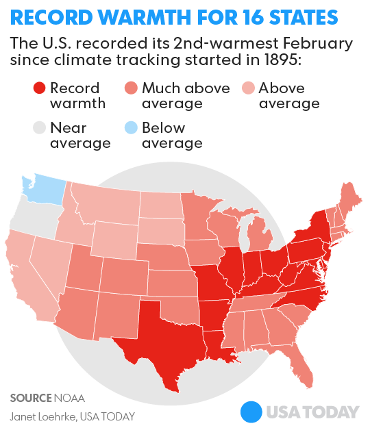
February record warm for 16 states, 145M Americans
8 March, 2017. The USA might not have recorded its warmest winter since data-keeping began more than 120 years ago, but it didn't feel that way for nearly half of Americans whose states sweltered through their warmest February on record.
Overall, the country recorded its 2nd-warmest February since climate tracking started in 1895, and its 6th-warmest winter, federal scientists announced Wednesday. Sixteen states experienced their warmest February ever recorded.
The average U.S. temperature last month soared to 7.3 degrees above average, scientists from NOAA’s National Centers for Environmental Information said. Only February 1954 was warmer.
(Photo: Brendan Smialowski, AFP/Getty Images)
Cities and towns across the nation tallied an incredible 11,743 record highs compared to 418 record lows in February — the highest ratio of highs to lows, meteorologist Guy Walton said. <...> Other notable weather anomalies last month included Massachusetts' first February tornado on record and Chicago's third snow-free February, NOAA said.
As for the winter of 2016-17, defined by meteorologists as the months of December-February, it was the nation's 6th-warmest on record. Two states — Texas and Louisiana — experienced their warmest winter.
Arkansas, Florida, Georgia, Kentucky, New Mexico, South Carolina, Tennessee and West Virginia each tallied their second-warmest winter on record. <...> The average national winter precipitation total was 8.22 inches, 1.43 inches above average, ranking this winter as the 8th-wettest on record. Rain and snow reached extraordinary levels in the West, especially in Nevada and Wyoming, which both experienced their wettest winter ever recorded.
The onslaught of storms that battered California throughout the winter gave the state its second-wettest winter on record, delivering a near-knockout blow to the state's ongoing drought. When the winter started, about 73% of the state was in a drought. That percentage dropped to about 9% as of the most recent U.S. Drought Monitor released Thursday. Source: usatoday.com
This was the coldest winter in 32 years (Seattle, US)
1 March, 2017. Were you born after 1985? Then you just experienced the coldest winter of your life. The National Weather Service says the Seattle-area has had the coldest winter season since the winter of 1984-1985 and one of the top 20 coldest winters since record keeping began in 1984.
The agency says the average temperatures taken at the Sea-Tac Airport weather station were colder than normal for December, January, and February, with 21 more nights near or below freezing than normal, adds Q13 Fox Chief Meteorologist Walter Kelley. <...> Yes, it rained/snowed a lot last month. 2017 was the wettest February in more than 50 years — since 1961 to be exact. Source: q13fox.com
Bermuda Experiences Record Low Temperature
7 March, 2017. Sub-tropical Bermuda has recorded its coldest March 5 since records began more than 50 years ago, the Bermuda Weather Service (BWS) said on Tuesday.
BWS said Sunday’s bone-chilling temperature fell to 47.7 Fahrenheit (8.7 Celsius) at 9.30 p.m., a record low for the date.
The previous low for March 5 was 52F recorded in 1978, the BWS’s deputy director James Dodgson said. The last time the island recorded a low similar to Sunday’s was on February 27, 2006, when it dropped to 47.1F. Source: jamaica-gleaner.com
One of the Weirdest Weather Months in U.S. History Set 20,000+ Records
2 March, 2017. The eastern U.S. experienced a rash of extreme weather in February 2017, from record warmth that has led to the early blooming of trees and plants to severe storms and deadly tornadoes. All of that strange weather brought back memories of one of the weirdest weather months in U.S. history five years ago when similar early-season events unfolded.
Persistent record warmth vaulted March 2012 to the most extreme temperature departure from average for any month on record in the Lower 48. It was 8.91 degrees Fahrenheit above the 1901-2000 average, according to NOAA's National Centers For Environmental Information (NCEI). Twenty-five states, all of them east of the Rockies, recorded their warmest March on record. <...> As a comparison, 11,000 warm temperature records were set in February 2017, mainly in the central and eastern states, according to preliminary data from NOAA's National Centers For Environmental Information. A number of cities saw a record or near-record warmest February, but we won't know how the month will rank as a whole for the Lower 48 until later in March. <...> A few tornadoes that occurred that month also touched down unusually far north for that time of year. A March 12 tornado in Midland County, Michigan, was the first tornado north of Interstate 96 in that state before March 20 dating to 1950. Source: weather.com
Minnesota Saw Its Record-Earliest Tornadoes During Monday's Severe Weather Outbreak
Australia's summer broke 205 weather records, climate group says
More than 200 weather records were broken during Australia's most recent summer, a climate group has warned. The Climate Council report, titled "Angry Summer", said the season was defined by intense heatwaves and bushfires in eastern Australia but heavy rain and flooding in the west.
Australia's summer - key records
Hottest summer on record for Sydney, Brisbane and Canberra
Moree, a town in New South Wales, experienced 54 consecutive days above 35°C
Adelaide endured its hottest Christmas Day in 70 years (41.3°C)
Perth had its highest summer rainfall on record (192.8mm; 7.6in)
News South Wales temperatures were 2.57C above average, a summer record
It showed climate change was being felt across Australia, the researchers said. <...>
At least 205 records were broken over the three-month period, the independent body said. <...> ource: bbc.com
California storms: Wettest Oct-Feb in 122 years
8 March, 2017. Fueled by a parade of “Pineapple Express” storms, California is in the midst of its wettest water year in 122 years of record-keeping, according to federal scientists.
Cars carefully drive through a flooded area on High Street during the morning commute in Oakland, Calif., on Tuesday, Feb. 7, 2017. The High Street near 880 always floods during heavy rain. (Laura A. Oda/Bay Area News Group)
Between October 2016 and February 2017, California averaged 27.81 inches of precipitation, the highest average since such records began being kept in 1895, according to data released Wednesday by the National Centers for Environmental Information, part of the National Oceanic and Atmospheric Administration. Source: mercurynews.com
Winter 'driest for Northern Ireland in 53 years'
6 March, 2017. Winter was Northern Ireland's driest in more than five decades, according to the Armagh Observatory.
The Observatory has reported that, taking the three winter months together, this winter was very dry, mild and slightly duller than average. Source: itv.com
Where Winter 2016-17 Ranked as One of the Warmest, Coldest, Wettest or Driest on Record
1 March, 2017. Winter 2016-17 was much warmer and wetter than average for parts of the United States, according to preliminary data compiled by the Southeast Regional Climate Center. One region, however, saw much colder temperatures than average, while a few areas reported one of the coldest winters on record.
The dots in orange indicate a top-5 warmest winter (December-February) and the dots in blue are where winter was a top-5 coldest. (Southeast Regional Climate Center)
Temperatures were very mild in much of the eastern half of the U.S., and for many, it didn't feel like winter. Meanwhile, chilly air gripped the Northwest, which gave the region one of its coldest winters on record. In terms of precipitation, winter will be remembered for the series of storms that brought heavy rain and mountain snow to California. For all the superlatives below, December through February is considered winter in meteorological record-keeping.
Warm and Cold Extremes
This winter will likely be remembered as warmer than average in many areas, especially the East. Numerous locations, from the Great Lakes and Northeast into the South, saw a top-10 warmest winter.
Houston recorded its warmest winter on record, with an average temperature of 61.5 degrees. The previous record was 57.8 degrees, which occurred in 2011-12. Average temperature refers to the average between each day's high and low temperatures compiled from December through February.
A record number of 80-degree days occurred in Houston during climatological winter: 22 days, or about 25 percent of all winter days.
Staying in Texas, Austin also recorded its warmest winter on record. The average temperature over the past three months was 58.6 degrees, which broke the previous record of 57.6 degrees in 1999-2000.
Dallas-Fort Worth also experienced a record-warm winter, with an average temperature of 53.6 degrees. This breaks the old record of 53.0 degrees, set in 1999-2000.
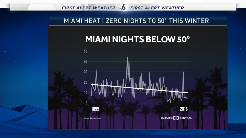
Portions of Florida also saw very mild conditions. Miami reported its warmest winter on record, with an average temperature of 74.2 degrees. The previous record was 73.1 degrees, which occurred in 2007-08.
Nights below 50° have been trending down. In 120 years cut in about half. This winter in #Miami? ZERO, a new record. Source: twitter.com/JohnMoralesNBC6
The temperature in Miami did not drop below 50 degrees the entire winter, which has never happened in 121 years of records in the South Florida city.
Fort Myers, Florida, also experienced its warmest winter in history. The average temperature was 70.9 degrees, breaking the prior record of 70.1 degrees from 1948-49.
A large swath of the eastern U.S. was mild enough to at least finish with a top-5 warm winter. Atlanta, for example, recorded its third-warmest winter, with an average temperature of 52.2 degrees. New Orleans also recorded its third-warmest winter at an average of 61.2 degrees.
Farther north, Raleigh, North Carolina, measured an average temperature of 47.9 degrees, making it the city's third-warmest winter. Washington D.C. also recorded its third-warmest winter, with an average temperature of 43.8 degrees.
In Boston, this winter will finish as the fifth-warmest. The average temperature during the last three months was 35.6 degrees. This is what the average high should be in mid-January, typically the coldest time of the year.
While the East saw a warmer-than-average winter, the Northwest saw conditions that were much colder than average.
Portland, Oregon, experienced its fifth-coldest winter on record, with an average temperature of only 37 degrees. This is equivalent to its average low in late February.
In Pendleton, Oregon, it was the third-coldest winter on record. The average temperature was just 28.4 degrees.
Farther south in Burns, Oregon, the second-coldest winter was recorded; the average temperature topped out at a whopping 18.6 degrees. The coldest winter on record there was in 1992-93, when the average temperature was only 17.6 degrees.
One state that really needed rainfall – California – received above-average precipitation this winter. In some locations, this resulted in a top-10 January for rainfall. But this eventually became too much of a good thing and led to flooding, mudslides and rockslides in parts of the state.
Record-Wet Winter
The dots in green indicate a top-5 wettest winter (December-February) and the dots in yellow are where winter was a top-5 driest.
Sacramento recorded its wettest winter on record, with 21.78 inches of rainfall, breaking the previous record of 20.65 inches set in 1955-56. The average over an entire year is 17.64 inches, and Sacramento picked up over four inches more in just three months. This is also a big difference from the past few years; last winter, only 8.01 inches of rainfall fell in California's capital city. The one piece of good news is that the rainfall in California helped reduce drought conditions in the Golden State.
It was also the wettest winter on record in Reno, Nevada, with 10.20 inches of rain measured from December through February. This far surpasses the previous record of 8.36 inches in 1955-56.
The nearby Sierra Nevada mountains were buried in feet of snowfall, with Mammoth Mountain setting a new snowfall record for any month in January: 245.5 inches, or just over 20 feet of snow. Their season total is now up to 512 inches – nearly 43 feet of snow.
In the South, San Antonio, Texas, saw its fourth-wettest winter, with 12.55 inches of rain reported. Farther east along the Gulf Coast, Pensacola, Florida, measured 24.97 inches of rain, the third-wettest winter for that city.
Parts of the upper Midwest also had very wet winters. In Rochester, Minnesota, it was the wettest winter on record, with 5.85 inches of precipitation. The previous record was 5.47 inches in 1887-88.
It was also tied for the wettest winter on record in Eau Claire, Wisconsin, where 6.16 inches of precipitation was reported. Wausau, Wisconsin, also had its wettest winter on record, with 6.60 inches of precipitation.
On the other end of the spectrum, Columbia, Missouri, recorded its fifth-driest winter, with only 2.23 inches of precipitation. It was the fourth-driest winter in Springfield, Illinois, where 2.38 inches of precipitation fell.
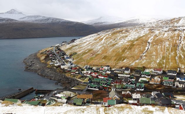
10 March, 2017. An average temperature of over 6 degrees was the highest since 1890
Despite its northerly location in the North Atlantic Ocean, temperatures on the Faroe Islands never tend to drop too low thanks to its close proximity to the Gulf Stream. But they have never been this high before!
This past winter has seen the highest average seasonal temperature in its capital Tórshavn since 1890-91, the first year they were recorded. The results were buoyed by a record warm December that doled out an average temperature of 6.9 degrees. Source: cphpost.dk
Today was the coldest March morning in Anchorage since 1999 (Alaska, US)
7 March, 2017. Southcentral Alaska experienced one of the coldest March mornings in nearly two decades. The temperature at Ted Stevens Anchorage International Airport dipped to 8 degrees below zero just before 8 a.m. Although that’s nowhere near the daily record of 24 degrees below zero, set in 1971, it is the coldest March temperature observed at the airport since 1999, when the temperature also dipped to 8 degrees below zero. Other parts of the Anchorage bowl were even colder, with the temperature on JBER dropping to 15 degrees below zero and Merrill Field dropping to 13 degrees below zero. Source: ktva.com
"It's horrible, just horrible. I left the house with (60) shells and used them all," Konrade said. He said he probably killed 40 cows, "and in a lot of places there weren't even very many left alive to put down."
"All in all, I'd guess I seen between 300 and 400 dead cattle," he said. "It was just a matter of putting animals out of their misery, doing them a favor. They were going to die anyway.
"It's horrible out there, the things I saw today. The fire was so big, and so much of Clark County burned, I don't see how anything lived through it."
The state of Kansas is burning at unprecedented levels. Parts of it are literally scorched earth at this point. And many people are having to shoot their own cattle in order to avoid the perils from all the smoke and fire. Clark county has been burned almost entirely. An entire county, smoldering in ashes.
According to Randall Spare, co-owner of Ashland Veterinary Center, via Kansas.com.
"Let me put it into perspective: If someone had 500 cattle on their ranch, I'd guess at least 80 to 90 percent were killed in the last day," Spare said. "That's not including the calves; we're really getting into calving season and there was a lot of baby calves on the ground."
The fires have all but taken down the entire county of Clarke.
The combination of severely dried out lands and 60 mph winds has led to a tinderbox in the state.
A drone view shows Meade, Kansas burning into ash and smoldering. This video was taken Monday evening, March 6th 2017 somewhere around Meade, Kansas about 6 miles high. These fires were spread out as far as the eye could see, for dozens of miles. They started in the panhandle of Oklahoma.


 Firefighters work to remove a fallen tree from a car caused by tropical cyclone Enawo in Antananarivo, Madagascar, on March 8, 2017.


You need to be a member of Earth Changes and the Pole Shift to add comments!
Join Earth Changes and the Pole Shift