"We warned at the start of ZetaTalk, in 1995, thatunpredictable weather extremes, switching about from drought to deluge,would occur and increase on a lineal basis up until the pole shift. Where this occurred steadily, it has only recently become undeniable. ZetaTalk, and only ZetaTalk, warned of these weather changes, at that early date. Our early warnings spoke to the issue of global heating from the core outward, hardly Global Warming, a surface or atmospheric issue, but caused by consternation in the core. Affected by the approach of Planet X, which was by then starting to zoom rapidly toward the inner solar system for its periodic passage, the core was churning, melting the permafrost and glaciers and riling up volcanoes. When the passage did not occur as expected in 2003 because Planet X had stalled in the inner solar system, we explained the increasing weather irregularities in the context of the global wobble that had ensued - weather wobbles where the Earth is suddenly forced under air masses, churning them. This evolved by 2005 into a looping jet stream, loops breaking away and turning like a tornado to affect the air masses underneath. Meanwhile, on Planet Earth, droughts had become more intractable and deluges positively frightening, temperature swings bringing snow in summer in the tropics and searing heat in Artic regions, with the violence of storms increasing in number and ferocity."
The wobble seems to have changed, as the temperature in Europe suddenly plunged after being like an early Spring, Alaska has its coldest temps ever while the US and much of Canada is having an extremely mild winter. India went from fatal cold spell to balmy again. Has the Earth changed position vs a vs Planet X to cause this?[and from another]Bitter cold records broken in Alaska - all time coldest record nearly broken, but Murphy's Law intervenes[Jan 30]http://wattsupwiththat.com/2012/01/30/bitter-cold-records-broken-in-alaskaJim River, AK closed in on the all time record coldest temperature of -80°F set in 1971, which is not only the Alaska all-time record, but the record for the entire United States. Unfortunately, it seems the battery died in the weather station just at the critical moment. While the continental USA has a mild winter and has set a number of high temperature records in the last week and pundits ponder whether they will be blaming the dreaded "global warming" for those temperatures, Alaska and Canada have been suffering through some of the coldest temperatures on record during the last week.
There has been no change in the wobble pattern, the wobble has merely become more severe. Nancy noted a Figure 8 format when the Earth wobble first became noticeable, in early 2005, after Planet X moved into the inner solar system at the end of 2003. The Figure 8 shifted along to the east a bit on the globe between 2005 and 2009, (the last time Nancy took its measure) as Planet X came closer to the Earth, encountering the magnetic N Pole with a violent push earlier in the day. But the pattern of the Figure 8 remained essentially the same. So what changed recently that the weather patterns became noticeably different in late January, 2012?
The N Pole is pushed away when it comes over the horizon, when the noon Sun is centered over the Pacific. This regularly puts Alaska under colder air, with less sunlight, and thus the historically low temps there this January, 2012 as the wobble has gotten stronger. But by the time the Sun is positioned over India, the N Pole has swung during the Figure 8 so the globe tilts, and this tilt is visible in the weather maps from Asia. The tilt has forced the globe under the hot air closer to the Equator, warming the land along a discernable tilt demarcation line.
The next loop of the Figure 8 swings the globe so that the N Pole moves in the other direction, putting the globe again at a tilt but this time in the other direction. This tilt is discernable in weather maps of Europe, again along a diagonal line. Depending upon air pressure and temperature differences, the weather on either side of this diagonal line may be suddenly warm or suddenly cold. The tilt and diagonal line lingers to affect much of the US and Canada, but the Figure 8 changes at this point to be an up and down motion, pulling the geographic N Pole south so the US is experiencing a warmer than expected winter under a stronger Sun. Then the cycle repeats, with the magnetic N Pole of Earth pushed violently away again as the Sun is positioned over the Pacific.
Would the Zetas be able to let us know what is causing the early break-up of the Arctic Ice, the ice seems to have taken on a swirling pattern at the same time, would this be wobble related?[and from another]http://www.vancouversun.com/news/national/Canada+Arctic+cracks+spec... The ice in Canada’s western Arctic ripped open in a massive “fracturing event” this spring that spread like a wave across 1,000 kilometres of the Beaufort Sea. Huge leads of water – some more than 500 kilometres long and as much as 70 kilometres across – opened up from Alaska to Canada’s Arctic islands as the massive ice sheet cracked as it was pushed around by strong winds and currents. It took just seven days for the fractures to progress across the entire area from west to east.[and from another]http://earthobservatory.nasa.gov/IOTD/view.php?id=80752&src=iot... A high-pressure weather system was parked over the region, producing warmer temperatures and winds that flowed in a southwesterly direction. That fueled the Beaufort Gyre, a wind-driven ocean current that flows clockwise. The gyre was the key force pulling pieces of ice west past Point Barrow, the northern nub of Alaska that protrudes into the Beaufort Sea.
The Figure 8 formed by the N Pole during the daily Earth wobble has shifted somewhat to the East, due to Planet X positioned more to the right of the Earth during its approach. This was anticipated, and well described in ZetaTalk, the Earth crowding to the left in the cup to escape the approach of Planet X, so the angle between these two planets would change slightly. This shift of the Figure 8 to the East is due to the push against the Earth’s magnetic N Pole occurring sooner each day than prior. Thus instead of occurring when the Sun is high over the Pacific, over New Zealand, it is now occurring when the Sun is high over Alaska. All the wobble points have shifted eastward accordingly.
This has brought a lingering Winter to the western US, and a changed sloshing pattern to the Arctic waters. Instead of Pacific waters being pushed through the Bering Straits into the Arctic when the polar push occurs, the wobble is swinging the Arctic to the right, and then later to the left, creating a circular motion in the waters trapped in the Arctic. Since the Earth rotates counterclockwise, the motion also takes this path. This is yet another piece of evidence that the establishment is hard pressed to explain. They are attempting to ascribe this to high pressure and wind, all of which are not new to the Arctic, but this circular early breakup of ice in the Arctic is new.
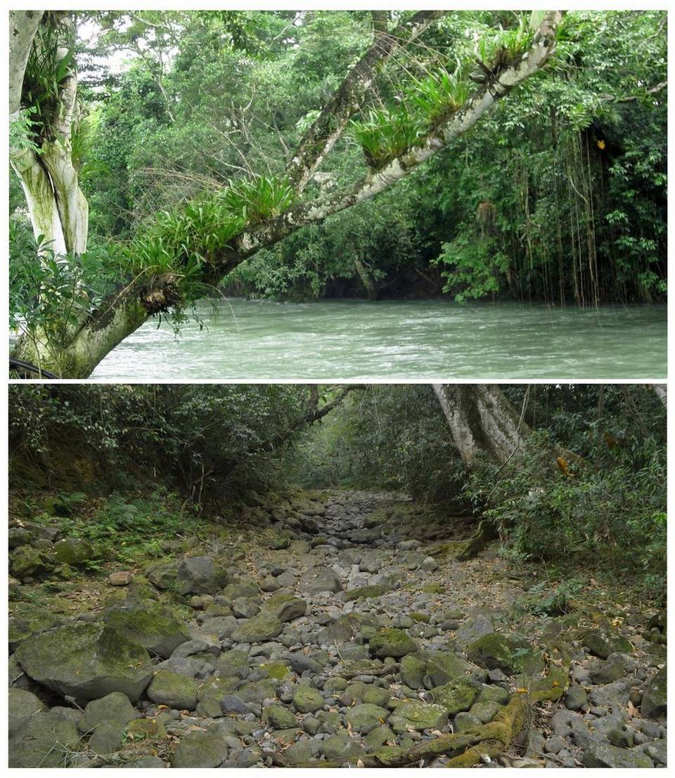
Atoyac River disappears overnight after giant crack opens up in Mexico
The Atoyac River, which crosses eight municipalities in the central mountainous area of eastern Mexican state of Veracruz, disappeared overnight after a giant crack opened up.
Inhabitants of Rancho San Fermin reported hearing a bang and feeling the earth rumbled as the ground cracked down.
Before / After. Segments of the River Atoyac are completely dry.
On Monday, the water had disappeared… And they found this giant 30 meters by 20 meters fissure in the ground.
The hole in the ground crosses the riverbed of the Atoyac River. It appeared about three kilometers from the source of the river, which supplies with water more than 10,000 families and sugar industries in the region.
Almost completely dried up…
Due to the disappearance of the Atoyac River, the Cotaxtla River is already below its normal level.
Only God and nature know exactly why the river disappeared entirely. They have exploited the river and it is now charging them back.
Hopefully, we are not facing another tragedy for these thousands of families.
Eastern Mediterranean Drought Is Worst in 900 Years
For January 2012, brown shades show the decrease in water storage from the 2002-2015 average in the Mediterranean region. Units in centimeters. The data is from the Gravity Recovery and Climate Experiment, or GRACE, satellites, a joint mission of NASA and the German space agency.
Parched Californians think they have it bad. But people in the eastern’s Mediterranean Levant region — which includes Cyprus, Jordan, Lebanon, Syria, Turkey, Israel and the West Bank and the Gaza Strip areas governed by the Palestinian Authority — have been enduring a drought that began back in 1998.
Now, a new study by NASA, Columbia University and University of Arizona researchers confirms that the drought most likely is the worst that the Mediterranean Levant has suffered in the past nine centuries.
The scientists studied tree rings and historical documents in an effort to reconstruct the region’s water history. They found that the most recent drought is not only longer but about 50 percent drier than the worst period in the past 500 years, and 10 to 20 percent drier than any drought since the 1100s A.D.
The results were accepted for publication in the Journal of Geophysical Research-Atmospheres, a publication of the American Geophysical Union.
The researchers also studied how drought in the region related to water conditions elsewhere. In most cases, for example, they found that droughts in the Levant corresponded to similarly dry conditions in Western Europe. Historically, that may have been a factor in international conflicts.
“Both for modern society and certainly ancient civilizations, it means that if one region was suffering the consequences of the drought, those conditions are likely to exist throughout the Mediterranean basin,” Kevin Anchukaitis, a co-author of the study and a climate scientist at the University of Arizona in Tucson, said in a press release.
“It’s not necessarily possible to rely on finding better climate conditions in one region than another, so you have the potential for large-scale disruption of food systems as well as potential conflict over water resources.”
Even if the drought eventually eases, a 2013 study by German scientists concluded that the region’s growing population and its water use may lead to chronic shortages.
Israeli, Jordanian and Palestinian water officials recently met in London to discuss improving their cooperation in coping with the region’s water situation. As this 2015 New York Times article details, Israel for years has invested in desalination plants and recycling waste water, and more than 50 percent of Israeli water needs are now filled by those sources.
Comment by jorge namour on February 27, 2016 at 3:02pm
VERY close call! A video pretty much in the spirit of exceptionally high temperatures over the Arctic in January: ice calving on a glacier terminus - and a close call.
Dozens killed after powerful cyclone ravages Fiji, looming Zika & Dengue threats (PHOTOS, VIDEO)
The footage posted on the Fijiian government website shows a massive scale of destruction on the small island – whole villages have been flooded amid Winston’s destructive winds, which reportedly reached about 325 kph.
“The images emerging from early aerial assessments of affected areas are truly heartbreaking, leaving little doubt about the ferocity of this cyclone,” said Osnat Lubrani, UN Resident Coordinator in Fiji.
Prime Minister Frank Bainimarama said that the recovery process will take “a long time.”
“Almost no part of our nation has been left unscarred. And many of our rural and maritime areas bore the brunt of Winston’s fury,” he said.
Aid agencies said that Fiji now may face outbreaks of the Zika and Dengue viruses, both of which are caused by infected mosquitoes.
"The threat of dengue and Zika in the coming days in Fiji is real," said Chris Hagarty, senior health program manager at Plan International Australia. "The period immediately following a disaster of this scale can be a particularly dangerous one."
According to the UN, more than 8,100 people “are currently sheltering in evacuation centers” and 150 houses have been destroyed in the storm.
“The cyclone is estimated to be one of the most severe ever to hit the South Pacific,” the organization said.
According to Alice Clements, a Communications Specialist with UNICEF Pacific, “the amount of destruction to infrastructure [in Suva, Fiji’s capital], livelihoods and homes that something like this can do is just immense. It can also completely destroy or severely damage school facilities and health facilities.”
The Navy stopped training its service members to navigate by the stars about a decade ago, focusing instead on electronic navigational systems. But fears about the security of the Global Positioning System and a desire to return to the basics of naval training are pushing the fleet back toward this ancient method of finding a course across open water.
So, why return now to the old ways? The Navy and other branches of the U.S. military are becoming increasingly concerned, in part, that they may be overly reliant on GPS.
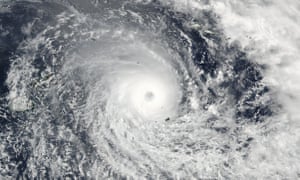
State of emergency declared as category five storm makes landfall, with winds gusting at up to 195mph
A 19 February Nasa satellite image of Cyclone Winston in the Pacific.
A state of emergency has been declared in Fiji as tropical Cyclone Winston made landfall on the country’s main island, with estimated wind gusts of up to 195mph (315km/h).
The Category Five storm is thought to be the strongest ever recorded in the southern hemisphere, and is the strongest Fiji has ever experienced.
The cyclone began to make landfall on the main island of Vitu Levu after a national curfew took effect at 6pm local time. It had earlier sunk boats and caused flash flooding on the nation’s outer islands, including Vanua Levu.
It is carrying average winds of 220km/h, with gusts of up to 315km/h recorded, according to Fiji’s Meteorological Service.
The Fijian government issued a list of 758 evacuation centres across the nation of just under 900,000 people. The country’s prime minister, Frank Bainimarama, said on Saturday that the island’s evacuation centres were operational and the government was prepared to deal with a potential crisis.
“As a nation we are facing an ordeal of the most grievous kind,” he wrote on Facebook. “We must stick together as a people and look after each other.”
In a later statement, Bainimarama said that the nation was “facing an ordeal of the most grievous kind”. He added: “We must stick together as a people and look after each other. Be alert and be prepared.”
ABC also quoted the prime minister expressing concerns that some people in urban areas did not appear to have heeded the warnings about the seriousness of the threat.
International flights to and from Fiji have been cancelled. As the country’s weather service warned people in the east to “expect very destructive hurricane-force winds”, Suva resident Alice Clements said the power had failed just after 5pm and she expected water supplies to be hit next.
“I have palm trees flying all around me at the moment,” Clements, an official with a UN agency, told Reuters.
The United Nations Office for the Coordination of Humanitarian Affairs (OCHA) said Winston was following a path that might spare Suva the full force of its winds. Category five is the highest ranking on the hurricane wind scale.
“The cyclone has tracked further north than expected over the past 24 hours,” the UN agency said.
The Fiji Times newspaper reported some damage, including a roof being blown off one home, from some of the nation’s smaller islands to the east as the cyclone began to strike there. It said there had been a run on supermarkets and stores as people stocked up on essential supplies.
Many people were hoping the cyclone’s path would remain as forecast and thread between the islands of Vanua Levu to the north and Vitu Levu to the south, which is home to the capital Suva, so that both islands would avoid a direct hit.
Airlines operating in the region including Virgin Australia, Jetstar, Qantas and Fiji Airways all reported cancelled flights or altered timetables, with passengers told to consult their carrier for information.
Irazu Volcano National Park in Costa Rica received several inches of hail/snow on Feb 13, 2016. This is the second time within three years that this type of event has taken place. Interestingly, in 2013, the same peak experienced its FIRST EVER recorded hail accumulations. Guatemala also received snowfall that year of six inches. Snow fell in Guatemala on February 10th:
Mystery black rain hits Michigan town: Tar-like substance falls from the sky and leaves residents bewildered as it covers cars, porches and driveways
The black, oily substance first appeared on at least six driveways in Harrison Township, Michigan, on Sunday
The mystery substance was seen on resident's roofs, cars and porches
Michigan Department of Environmental Quality officials collected samples of the substance on Wednesday
Residents originally believed that the substance could have come from the nearby Selfridge Air National Guard Base
The airbase released a statement saying it was not coming from their area
It could be at least a week before the city discovers what the substance is
A city in Michigan is perplexed after a a tar-like substance has rained down on their cars, porches and driveways this week.
The black, oily substance first appeared on at least six driveways in Harrison Township on Sunday, and days later, what the material is still remains a mystery.
Michigan Department of Environmental Quality officials collected samples of the substance on Wednesday.
A black, oily substance first appeared on at least six driveways in Harrison Township, Michigan, on Sunday
The mysterious substance remained on outdoor surfaces through Wednesday, when Michigan Department of Environmental Quality officials collected samples
The city's fire chief sad that it is not bird droppings and is not flammable, according to WXYZ.
Harrison Township resident Paul Schlutow, 73, said 'everybody's concerned' about the substance and the major concern is that the substance could potentially be harmful.
Residents originally believed that the substance could have come from the nearby Selfridge Air National Guard Base, but the base released a statement saying it was not coming from their location.
'There is no indication that the substance in question came from a military aircraft of any type,' the statement said.
The statement said the airbase has 'been in communication with the Michigan Dept. of Environmental Quality, which was sending a representative to the area in question to review the material'.


 Before / After. Segments of the River Atoyac are completely dry.
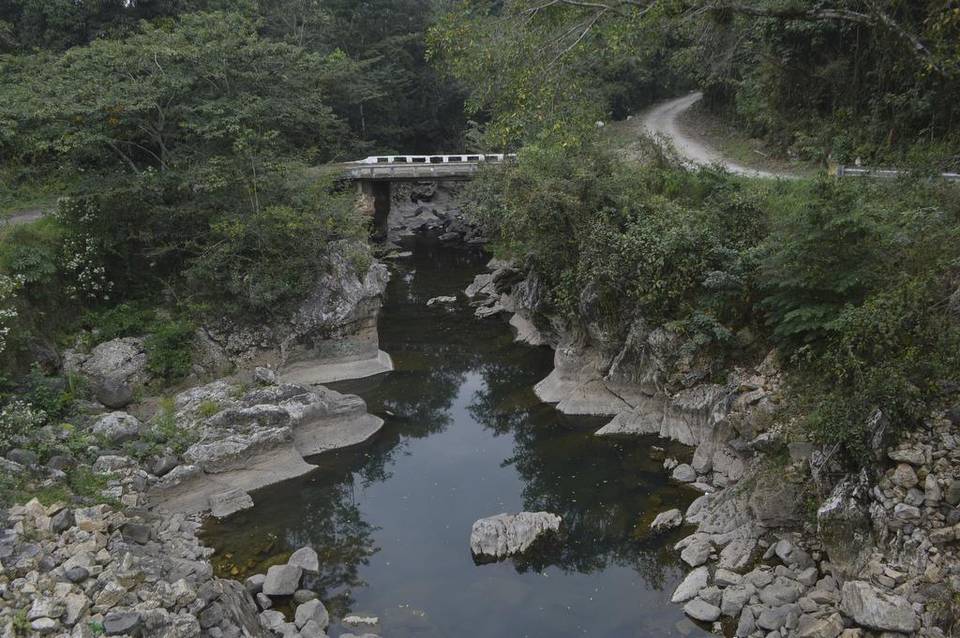 Almost completely dried up…


You need to be a member of Earth Changes and the Pole Shift to add comments!
Join Earth Changes and the Pole Shift