Please Place Evidence of the 7 of 10 Plate Movements Here
Kojima had created small snips of Konstantin's animation of the 7 of 10 Plate Movements.
Here is the full 7 of 10 Animation by Konstantin.
This blog is the place to document ongoing earth changes related to the 7 of 10 plate movements as described by the Zetas.
ZetaTalk: 7 of 10 Sequence
written October 16, 2010
The 7 of 10 scenarios describe plate movements, and for this to occur something has to release the deadlock, the current stalemate where the plates are locked against each other. Once the deadlock is broken and the plates start moving, sliding past each other, new points where the plates are locked against each other develop, but these are weaker locks than the one at present. The current lock, as we have so often stated, is the Indo-Australian Plate which is being driven under the Himalayans. This is no small lock, as the height of the Himalayans attests. Nevertheless, the activity in this region shows this likely to be the first of the 7 of 10 scenarios to manifest. Bangladesh is sinking and the Coral Sea is rising, showing the overall tipping of the Indo-Australian Plate. Now Pakistan is sinking and not draining its floods as it should, while Jakarta on the tongue of Indonesia is also sinking rapidly, showing that the tilt that will allow Indonesia to sink has already started.
Meanwhile, S America is showing signs of a roll to the west. Explosions on islands just to the north of the S American Plate occurred recently, on Bonaire and Trinidad-Tobago, and the Andes are regularly being pummeled. There is a relationship. As the Indo-Australia Plate lifts and slides, this allows the Pacific plates to shift west, which allows S America to shift west also. This is greatly increased by the folding of the Mariana Trench and the Philippine Plate. But it is the Indo-Australian Plate that gives way to incite change in these other plates, and this is what is manifesting now to those closely following the changes. Once the folding of the Pacific has occurred, Japan has been destabilized. We are not allowed to give a time frame for any of these plate movements, but would point out that it is not until the North Island of Japan experiences its strong quakes that a tsunami causing sloshing near Victoria occurs. There are clues that the New Madrid will be next.
Where the N American continent is under great stress, it has not slipped because it is held in place on both sides. The Pacific side holds due to subduction friction along the San Andreas, and the Atlantic side holds due to the Atlantic Rift's reluctance to rip open. What changes this dynamic? When S America rolls, almost in step with the folding Pacific, it tears the Atlantic Rift on the southern side. This allows Africa freedom to move and it rolls too, dropping the Mediterranean floor above Algeria. What is holding the N American continent together has thus eased, so that when the Japan adjustments are made, there is less holding the N American continent in place than before, and the New Madrid gives way. We are also not allowed to provide the time frame between the Japan quakes and New Madrid. Other than the relationship in time between the New Madrid and the European tsunami, no time frame can be given. The sequence of events is, thus:
- a tipping Indo-Australia Plate with Indonesia sinking,
- a folding Pacific allowing S America to roll,
- a tearing of the south Atlantic Rift allowing Africa to roll and the floor of the Mediterranean to drop,
- great quakes in Japan followed by the New Madrid adjustment,
- which is followed almost instantly by the tearing of the north Atlantic Rift with consequent European tsunami.
Source: http://www.zetatalk.com/index/zeta584.htm
Tipping Indo-Australia Plate with Indonesia sinking,
http://zetatalk.com/7of10/7of10-23.htm
http://zetatalk.com/7of10/7of10-24.htm
http://zetatalk.com/7of10/7of10-25.htm
http://zetatalk.com/7of10/7of10-26.htm
http://zetatalk.com/7of10/7of10-28.htm
http://zetatalk.com/7of10/7of10-30.htm
http://zetatalk.com/7of10/7of10-31.htm
http://zetatalk.com/7of10/7of10-32.htm
http://zetatalk.com/7of10/7of10-34.htm
http://zetatalk.com/7of10/7of10-37.htm
Folding Pacific
http://zetatalk.com/7of10/7of10-33.htm
http://zetatalk.com/7of10/7of10-38.htm
http://www.zetatalk.com/info/tinfx351.htm
http://zetatalk.com/7of10/7of10-47.htm
South American Roll
http://zetatalk.com/7of10/7of10-39.htm
http://zetatalk.com/7of10/7of10-40.htm
http://zetatalk.com/7of10/7of10-41.htm
http://zetatalk.com/7of10/7of10-42.htm
http://zetatalk.com/7of10/7of10-43.htm
http://zetatalk.com/7of10/7of10-44.htm
http://zetatalk.com/7of10/7of10-45.htm
http://zetatalk.com/7of10/7of10-47.htm
African Roll
http://www.zetatalk.com/7of10/7of10-46.htm
http://zetatalk.com/7of10/7of10-47.htm
http://zetatalk.com/7of10/7of10-48.htm
http://zetatalk.com/7of10/7of10-52.htm
Japan Quakes
http://www.zetatalk.com/7of10/7of10-53.htm
http://zetatalk.com/7of10/7of10-54.htm
New Madrid
http://www.zetatalk.com/7of10/7of10-59.htm
http://www.zetatalk.com/7of10/7of10-60.htm
http://zetatalk.com/7of10/7of10-61.htm
http://www.zetatalk.com/7of10/7of10-62.htm
http://zetatalk.com/7of10/7of10-63.htm
http://zetatalk.com/7of10/7of10-64.htm
http://zetatalk.com/7of10/7of10-65.htm
http://zetatalk.com/7of10/7of10-68.htm
European Tsunami
http://zetatalk.com/7of10/7of10-70.htm
http://zetatalk.com/7of10/7of10-71.htm
http://zetatalk.com/7of10/7of10-72.htm
http://zetatalk.com/7of10/7of10-73.htm
http://zetatalk.com/7of10/7of10-74.htm
Due to the slowing of the 7 of 10 plate movements by the Council of Worlds the impact of some of the events described above will be lessened.
The Zetas explain:
ZetaTalk: Pace Slowed
Written May 19, 2012
The effect of the thousands of humming boxes placed along fault lines and plate borders can be seen in several incidents that have occurred since the start of the 7 of 10 plate movements. The lack of tsunami during the 7 of 10 sinking of the Sunda Plate is one such example. We predicted at the start of the 7 of 10 scenarios in late 2010 that the Sunda Plate sinking would occur within 2-3 weeks, yet it dragged on through 2011. At the time we had predicted tsunami on the Sunda Plate, in general equivalent in height to the loss of elevation for a coastline. None of this occurred due to the slower pace.
The pace of mountain building in S America, where slowed, has still resulted in rumpling up and down the Andes, and stretch zone accidents likewise in lands to the east of the Andes. The shape of S America has clearly changed. Will the islands in the Caribbean be spared? At some point, as with the magnitude 7.9 quake in Acapulco on March 2, 2012 a significant adjustment will need to occur, and this will include depressing the Caribbean Plate so it tilts, sinking the islands and lands on that portion of the plate to the degree predicted. But the S American roll will likely continue to avoid the magnitude 8 quakes we originally predicted in deference to slow rumpling mountain building. The African roll was anticipated to be a silent roll in any case, so the slowed pace would not affect the outcome.
Will the slowed pace prevent the 7 of 10 scenarios for the Northern Hemisphere? Bowing of the N American continent has reached the point of pain, with breaking rock booming from coast to coast, but still there have been no significant quakes in the New Madrid area. Yet this is past due, and cannot be held back indefinitely. What has and will continue to occur for the Northern Hemisphere scenarios are silent quakes for Japan, which has already experienced drastic subduction under the north island of Hokkaido where mountain building is occurring as a rumple rather than a jolt. However, the anticipated New Madrid adjustment cannot be achieved without trauma. But this could potentially occur in steps and stages such that any European tsunami would be significantly lessened.
All rights reserved: ZetaTalk@ZetaTalk.com
Source: http://www.zetatalk.com/7of10/7of10109.htm
ZetaTalk , Written March 10, 2012
What happens when the pace of plate movement is slowed? The likelihood of tsunami is definitely reduced, as can be seen in the sinking on the Sunda Plate. The sinking occurred, and is almost complete, yet the possibility of tsunami we predicted for various regions on the Sunda Plate were avoided. The height and force of a tsunami is directly related to the degree of displacement in the sea floor, and if this happens in steps rather than all at once the displacement will be less for any given step.
This bodes well for the European tsunami. If the Council of Worlds is still imposing a slower pace on the 7 of 10 plate movements, this tsunami will definitely be lessened. The tear in the North Atlantic will be slight, each time. The amount of water pouring into this void will be less, each time. And the rebound toward the UK will likewise be less, each time. But our prediction is the worst case situation, and it also reflects what the Earth changes, unabated, would produce.
But what does a slower pace do to land masses where jolting quakes are expected? Does this reduce the overall magnitude of the quakes anticipated? Large magnitude quakes result when a catch point along plate borders is highly resistant, but snapping of rock finally results. Usually there is one place, the epicenter, where this catch point resides and a long distance along the plate border where smaller quakes have prepared the border for easy movement. A point of resistance within the body of a plate, such as the New Madrid, can likewise resist and suddenly give.
There is no way to lessen the resistance at these catch points, though the tension that accompanies such points can be reduced so that the quake itself is delayed. What this means for a slower 7 of 10 pace is that large magnitude quakes will be spread apart in time, and their relationship to our predictions thus able to be camouflaged by the establishment. Where sinking (such as the Caribbean Island of Trinidad) or spreading apart (such as to the west of the Mississippi River) are to occur, these land changes will eventually arrive. But like the sinking of the Sunda Plate, a slower pace unfortunately allows the cover-up time to maneuver and develop excuses.
All rights reserved: ZetaTalk@ZetaTalk.com
Views: 117193
Comment
-
Comment by Stanislav on December 31, 2015 at 3:25pm
-
South America floods
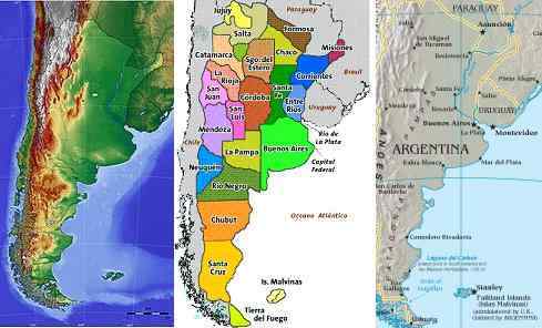
We have already stated that the Cordoba range would be a safe zone, safe from the tidal waves rushing in from the Atlantic. Hot springs appear in many places around the world, where the crust is thin, primarily due to stretching. Argentina, at Buenos Aires, will experience stretching as the top part of S America is pulled to the west while the tip of S America is nailed firmly at the Antarctic Plate. The bay at Buenos Aires will rip open, as we have stated. Thus inland, in San Luis, there are hot springs. This will not result in volcanic eruptions during the pole shift.
ZetaTalk ™ May 4, 2011
What is the relationship between recent large quakes along the southern Andes and the horrific flooding in several states in SE Brazil? S America is tugging to the west, along its top side. The trend has been in place for many months, with the Caribbean Plate sinking just above Colombia and in Panama. But as much as there is stress along the northern Andes where the S American Plate slides over the Nazca Plate, there is more stress along the southern Andes. Why would this be? The rolls that S America and Africa will do is primarily at the Equator, where the spreading apart of the Atlantic and the compressing of the Pacific is at an accelerated pace. Thus, the plates to the west of the top of S America have already granted S America room to roll.
But as we have explained, the tip of S America does not roll, but remains nailed in place. This is due to the Antarctic Plate, which also abuts the south Andes. The Antarctic Plate is not compressing, as it is one solid piece. For the top portion of S America to roll to the west, something must thus give, and to some extent this is the southeastern portion of S America. There is already a seaway developing at Buenos Aires. But draw a line from the top of the current quake activity along the southern Andes to the southeast coast of Brazil and they line up! For S America to be pulled in a bow like this, the land is stretched, and stretched land sinks. Thus, where they did have rain, the rain was not excessive to the degree to explain the flooding. The inland rivers are not draining properly, due to the stretch and consequent sinking.ZetaTalk ™ January 15, 2011
ZetaTalk: THE STRETCH ZONE, THAT SINKING FEELING
30 December, 2015
30 December, 2013
27 December, 2015 [Click to view 500m resolution Source: EOSDIS Worldview]

El Nino blamed for South America's 'worst flooding in 50 years' Source: ultimahora.com
https://translate.google.com/translate?sl=auto&tl=en&js=y&a...
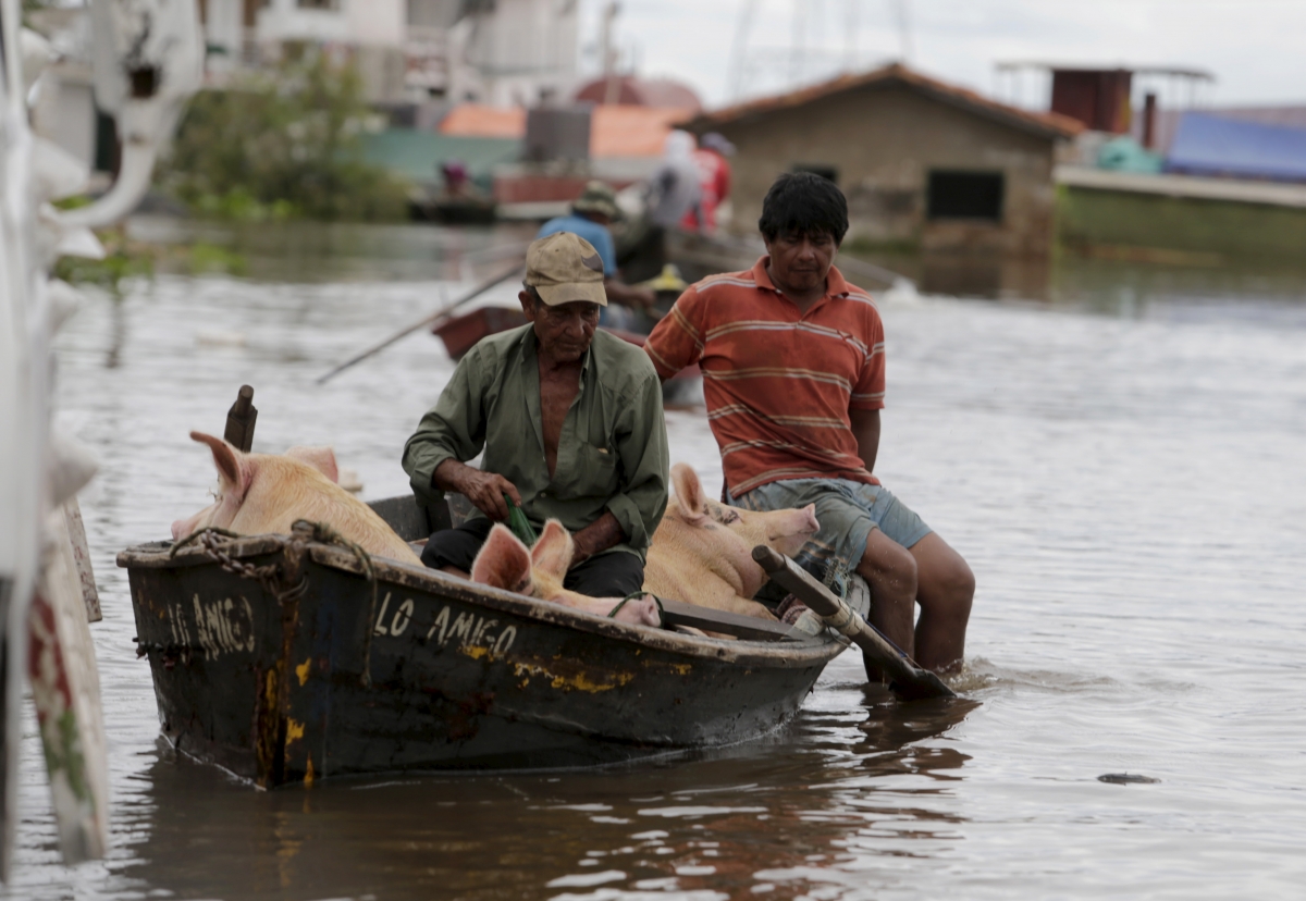
Many rivers in South America have breached their banks (Jorge Adorno/Reuters) Source: ibtimes.co.uk
Houses are seen partially submerged in floodwaters in Asuncion, December 27, 2015. (REUTERS/JORGE ADORNO) Source: reuters.com

The River Paraguay, which flows by the country's capital, Asuncion, has already reached 7.82 meters (25.66 feet), its highest level since 1992. Source: clarin.com
https://translate.google.com/translate?sl=auto&tl=en&js=y&a...

Air record flooding in Bella Union, Uruguay. Source: twitter.com
27 December, 2015. El Nino blamed for South America's 'worst flooding in 50 years'

Aerial view of Paysandu, flooded by water. Source: elpais.com.uy
https://translate.google.com/translate?sl=auto&tl=en&js=y&a...
At least 150,000 people have fled the border areas of four South American countries after what the "worst flooding in 50 years", brought about by downpours caused by the El Nino weather pattern. Heavy rains have swollen three major rivers affecting Paraguay, Argentina, Uruguay and Brazil.
Paraguay is the hardest hit with around 130,000 people forced to evacuate their homes near the capital city of Asuncion, the BBC reported. About 7,000 residents of Alberdi, which lies south of Asuncion and close to the Paraguayan river, have also been asked to leave their homes.
President Horacio Cartes has declared a state of emergency in Asuncion and several nearby areas, and released $4m (£2.70m) to assist flood-hit families. According to reports, four people have been killed by fallen trees in Paraguay.
"(The flooding) was directly influenced by the El Nino phenomenon which has intensified the frequency and intensity of rains," Paraguay's national emergencies office said.
In Argentina's north-east areas, some 20,000 people have fled their homes. "We are going to have a few complicated months. The consequences will be serious," the governor of Argentine's Corrientes region, Ricardo Colombi, said.
At least two people have died in the floods in Argentina, where Entre Rios, Corrientes and Chaco provinces are the worst affected. National cabinet chief Marcos Pena said Argentina lacked proper infrastructure which will be addressed to prevent future flooding. He said government aid was on its way to flood-affected areas.
In Uruguay, some 9,000 people living near swollen rivers have been forced to leave their homes. The country's emergencies office said it expected the water levels in the rivers to remain high for several days.
In Brazil's south-eastern state of Rio Grande do Sul, at least 7,000 residents have left their homes, civil defence authorities told AFP. Source: ibtimes.co.uk
31 December, 2015. Since December 15th, Paraguay has been in a state of emergency due to flooding caused by unusually heavy rainfall for the season. Paraguayan Red Cross Branch Operations Centres, along with Asunción Municipality and the National Emergency Operations Directorate, estimate that 26,000 families have been affected over 42 zones in different areas of the country. The torrential rains have caused the overflow of the Jejuí, Paraguay, Parana, Estero Yetity, Tebycuary, Tebycuarymi, Aquidaban, Aguaray-mí y Aguaray-Guazú and Ypane rivers.
The majority of the affected population reside in the riverside areas of the city of Asunción and the Central Department. Their proximity to rivers that are prone to flooding exacerbates their existing vulnerabilities. This history of flooding includes May 1983 where 6,700 families were affected, and again in July 2014 where 17,789 families were affected in Asunción alone. The current floods have forced the evacuation of 15,000 families in Asunción to 114 temporary shelters. Source: reliefweb.int
-
Comment by Khan on December 28, 2015 at 1:49am
-
4,300 Earthquakes Hit Indonesia in 2015
27 December, 2015
TEMPO.CO, Jakarta - At least 4,300 earthquakes measuring more than 3 in Richter scale happened in Indonesia in 2015, according to a report. As many as 360 earthquakes among them were felt and 7 of them were destructive.
A seismologist from the Bandung Institute of Technology Irwan Meilano said that on average, in Indonesia, earthquakes happened every day.
Irwan also said that the data was taken from the Meteorology, Climatology and Geophysics Agency (BMKG).
"Ironically, almost all destructive earthquake happen in areas not included in the earthquake map,” Irwan said on Sunday (27/12).
-
-
Seismic activity intensifies in Azerbaijan
14 December 2015
By Nigar Orujova
Seismic activity intensified in Azerbaijan as the country faced about 7,000 earthquakes in 2015.
Magnitude of more than 80 earthquakes ranged from 3.1 to 5.9, and tremors of 17 were felt, the Republican Seismological Service Center reported.
Azerbaijan locates in seismically active zone. Scientists believe that seismic zones with the potential to produce dangerous force cover the entire country, while the Alpine-Himalayan seismic belt passes directly through Azerbaijan.
An increase in seismic activity is observed since the beginning of the year in the northern part of Azerbaijan – in Oghuz, Shamakhi-Ismayilli, Shabran seismic zones, as well as in the southern part – the Talysh seismic zone, according to the center.
The seismic activity in the Caspian Sea increased in 2015 compared to the last year, but the level seismic energy released through tremors was lower.
In the first quarter of this year, the magnitude of the strongest earthquakes in the Caspian Sea was 5.4. This earthquake occurred on March 22, but the tremors were not felt.
The strongest earthquake of the second quarter of the year occurred in the Goranboy region (4.7), the third quarter – in the territory of Oghuz region (5.9), and in the fourth quarter again the strongest earthquake hit Oghuz (4.0).
The last earthquake recorded in the country was observed in the Caspian Sea to the north of Baku on December 11. The strength of the quake was 3.4 on the Richter scale; the epicenter was located at a depth of 61 km.
The Seismological Service Center noted that the seismic tension on the southeastern slope of the Greater Caucasus has decreased this year, while it remains the same in regions of the Lesser Caucasus and Talysh Mountains.
In November, the Ecology and Natural Resources Ministry announced that Azerbaijan may face 3-4 magnitude earthquakes in the near future and named zones that have potential risks of earthquakes.
Shaki-Oghuz, Central Caspian seismogenic zone and partly Southeastern sector of Shamakhi seismically active zone were named as areas of potential seismic risk based on the operational analysis of seismic and geodynamic conditions in Azerbaijan in the end of October.
Last year was also marked with an intensification of seismic processes as well as the most powerful earthquakes that Azerbaijan has seen in the past 15 years.
Six earthquakes measuring over 5.0 on the Richter scale occurred in Azerbaijan in 2014, releasing a tremendous volume of energy.
-
Comment by jorge namour on December 8, 2015 at 2:26pm
-
Etna earthquakes, moves the fault of Pernicana: all connected to the eruption, lesions in the streets SICILY ITALY
8 December 2015
Etna earthquakes, tremors associated eruption: hypocenters very shallow seismic resentment particularly significant
http://www.meteoweb.eu/2015/12/terremoti-etna-si-muove-la-faglia-de...
https://translate.google.com/translate?sl=it&tl=en&js=y&...
The 'movement' of the fault of Pernicana, on the north-northeast of the 'Etna, is causing an earthquake swarm with - total - twenty shook the volcano. Three events of greater intensity ', in magnitude, measured by INGV Catania: magnitude 3.8 at 10:28, magnitude 2.9 at 10:32, and magnitude 3.2 at 11:53.
The depth 'epicenter, almost superficial, between 0 and 2 kilometers of events linking earthquakes of the attivita' of eruptive 'Etna. Experts from the National Institute of Geophysics and Volcanology in Catania are monitoring the phenomenon and also checking the deformations to the ground.
There have been reports of roads of the 'Etna presenting the' injuries'. The events were felt in some countries on the slopes of 'Etna, but, at the moment, are not reported damage to property or persons.
-
Comment by Kojima on December 7, 2015 at 3:51pm
-
* Monitoring of Ground Motion in REV
http://rev.seis.sc.edu/index.html
http://rev.seis.sc.edu/stations.html
[Tipping Indo-Australia Plate]]
* II.DGAR; Diego Garcia, Chagos Islands, Indian Ocean; 7.41 S, 72.45 E
http://rev.seis.sc.edu/stations/?zip_or_station_code=II.DGAR
[2015/12/03 -12/07]
-
-
-
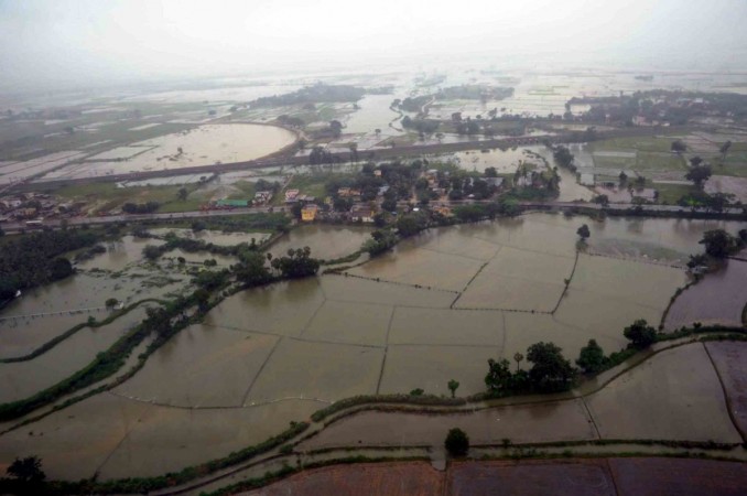
2 December, 2015. Chennai floods: Worst disaster since tsunami? Source: economictimes.indiatimes.com with video
India unseasonal floods

Prime Minister Narendra Modi tweeted on Thursday that he was leaving for Chennai to take stock of the flood hit city. Modi tweeted: "Leaving for Chennai to take stock of the situation arising due to the devastating floods. Source: indiablooms.com

Stranded travellers look an as floodwaters lap at the end of a highway in Chennai on December 2, 2015. (AFP photo)

Army personnel rescuing people during their flood relief operations in rain-hit areas in Chennai on Wednesday. PTI. Source: english.manoramaonline.com

Thousands of people have been rescued by the army and police. Source: bbc.com

The federal weather office has predicted three more days of torrential rains. Source: bbc.com
3 December, 2015. Chennai floods: Death toll crosses 260, Home Minister says situation ‘very alarming’
Terming the situation in flood-hit Chennai as “very alarming”, Home Minister Rajnath Singh on Thursday said in the Lok Sabha that the Centre will extend all possible assistance to the state governments in dealing with natural calamities.
“It would not be an exaggeration to say that Chennai has become an island as it has been cut off from all national and state highways,” he said, responding to a discussion on the flood situation in Tamil Nadu, Pudducherry and Andhra Pradesh.
Sharing concern of members on the magnitude of the calamity, he said the megapolis was witnessing an unprecedented emergency situation with unrelenting rains which was a record in the last 100 years. <...> Source: indianexpress.com3 December, 2015. Rain Stops, But Flood Waters Rising in Parts of Chennai. Here's Why.
There has been little rain in Chennai today and the sun is finally out, but the water level in many of its residential areas is increasing, owing to the excess water released from the dam at Chembarambakkam.
For the residents, what is worse is that the release is being done without warning - in what is understood to be a violation of procedure.In areas like Kotturpuram, where the waters have receded, residents are living in fear that another bout of water will be released from the dam later today.
"What worries us is most is if the worst is over or it is yet to come. The water level is increasing every hour," said a resident in Mylapur, one of the posh areas of Chennai.
"We do not know when the reservoirs are overflowing or how much water is discharged. We do not know when more water will be discharged... We have no power, no internet, or essential items," he added.
<...>
On Wednesday, commissioner of Chennai corporation, Vikram Kapur, said the rivers were still at the danger level and the surplus water was being released into Chennai. "None of the drains can work with such heavy rain. If this kind of rain happens again we are in for a tough time," he had said. Source: ndtv.com3 December, 2015. Andhra Pradesh rain: 54 dead; losses pegged at Rs 3,000 crore
An aerial view of the flood affected areas of the Andhra Pradesh on Nov 18, 2015. [Representational Image] IANS. Source: ibtimes.co.in
Torrential rainfall in some parts of southern India has wreaked havoc in Andhra Pradesh, where at least 54 people have been reported dead.
Rain lashed the Nellore, Chittoor and Prakasam districts of Andhra Pradesh, bordering Tamil Nadu, on Wednesday.
The heavy downpour in the last two days has caused flooding in low-lying areas of Nellore, Chittoor and Prakasam. Streams and tanks were reportedly overflowing.
Normal life in some parts of the three districts has been crippled due to the heavy rain. At least 5,000 people in the Nellore district have been shifted to 50 relief camps.
The showers damaged crops and disrupted road and train services in the affected regions, an IANS report quoted officials as saying. <...> Source: ibtimes.co.in
3 December, 2015. India’s Tamil Nadu grapples with worst floods in a century
The heaviest rainfall in more than 100 years has devastated swathes of the southern Indian state of Tamil Nadu, with thousands forced to leave their submerged homes and schools, offices and a regional airport shut for a second day Thursday.
At least 269 people had been killed in the state since heavy rains started in the beginning of November, said India’s Home Minister Rajnath Singh, although no deaths have been reported in the latest deluge.
“I can’t even believe that this much water was possible in Chennai,” one woman told NDTV channel as she stood in waist-deep water in the state capital.
“We don’t have any food. We don’t have any milk,” she said, adding that she had stepped out to see if she could find a shop selling some food. “But I’m scared to walk down this road. The water comes up almost to my hips.”
Chennai has received more than 330 millimeters (13 inches) of rain over the last 24 hours, which is significantly higher than the regional average for the entire month of December, Singh said.
While the downpour eased early Thursday, the Indian Meteorological Department has predicted more heavy rain in several parts of the state through the rest of the week. The rains have been caused by a depression in the Bay of Bengal, the agency said.
Separately, news reports said that flood waters released from a lake on the outskirts of Chennai inundated more neighbourhoods in the city. The Adyar river, which runs through Chennai before draining into the Bay of Bengal, was flowing above a danger mark. Source: globalnews.ca
-
-
India unseasonal floods

People wade through the flood waters in Chennai on Dec. 2.(EPA/STR). Source: qz.com

A man carries a dog and wades through a flooded street in Chennai on Dec. 2.(AP Photo). Source: qz.com

Indians help a man carry his two-wheeler on a cycle cart as they wade through a waterlogged subway in Chennai, India, Monday, Nov. 9, 2015. (AP Photo/Arun Sankar K.). Source: accuweather.com

A view of a residential area flooded following heavy rain in Chennai, Tamil Nadu state, India, Tuesday, Nov. 17, 2015. Incessant rain that lashed the city since Saturday night flooded several parts of Chennai. (AP Photo/Arun Sankar K). Source: accuweather.com

Heavy rains caused flooding in and around Chennai, India, on Dec. 2. Photo by Reuters stringer. Source: pbs.org

People travel by boat to safer places through a flooded road in Chennai, India, on Dec. 2. Photo by Reuters stringer. Source: pbs.org

In view of the water logging, Chennai Airport authorities have shut operations till 6 AM tomorrow. Chennai rains as well as those across Tamil Nadu have virtually broken a 100-year-old record with one day’s rainfall covering a month’s average have flooded areas in Vadapalani, Valasaravakkam and Nandamvakkam as nearby lakes overflowed into the city. (Photo courtesy: Twitter). Source: financialexpress.com
2 December, 2015. Rains, floods devastate Chennai, army rescues people
Soldiers joined the rescue and relief work and rescued 65 men and women till Wednesday afternoon, officials said, adding that more troops were on their way to Chennai from Bengaluru.
Urban Development Minister M. Venkaiah Naidu said in New Delhi that the situation in Chennai was "unheard of and unprecedented", and promised all help to the beleaguered city and other area.
Residents and officials admitted that almost everyone in Chennai, a sprawling city with over 4.6 million people, had been affected one way or the other by the devastating floods caused by torrential rains. <...> Source: business-standard.com
25 November, 2015. Unseasonal rain takes toll on health
Not just dengue, but cases of water-borne diseases like diarrhoea, viral fever and allergies too have gone up following unseasonal rain in the last two days.
"Besides cases of viral fever and body ache, I have been seeing quite a few cases of diarrhoea and nasal allergy . People who are mainly dependent on outside food and water are the ones who are more at risk of getting water-borne infections," said senior physician Prakash Mahajan, who runs a clinic in Model Colony .
Mahajan said, "We are experiencing two seasons in a day . In the morning, it is winter but as the day progresses, we get rain.This wide fluctuation in temperature boosts growth of micro organisms. Schools and colleges have re-opened post Diwali vacations; hence transmission or person-to-person spread of infection has become very easy .Besides, cases of dengue will rise now as the water accumulated may act as breeding ground for mosquitoes." <...> Source: timesofindia.indiatimes.com
2 December, 2015. Flights cancelled as floods strike Chennai airport

Met office has said that the weather patterns are due to a slow moving depression over southwest Bay of Bengal. Photograph: PTI. Source: rediff.com
All flights into and out of Chennai, Tamil Nadu, have been cancelled following floods at the airport. Airport director Deepak Shastri said floodwaters at the airport had reached the undercarriage of aircraft.
He was quoted as saying that flights would be unable to take off till the water level recedes. Meanwhile, army and navy personnel were deployed early today in low-lying areas of Chennai where thousands of people are reportedly stranded in their homes due to the worsening floods.
The authorities have intensified search and rescue operations. According to officials, schools and colleges were forced to shut down and these premises were being used as relief centres.
Domestic and inter-state train services were crippled after water flooded rail tracks.
Prime Minister Narendra Modi contacted Tamil Nadu Chief Minister J.
Jayalalithaa late last night and assured her of central government assistance. Source: thestar.com.my
2 December, 2015. How Army, Navy and Air Force have responded to the deluge
Chennai is witnessing its worst crisis in decades. Large parts of the capital city and other parts of the coastal Tamil Nadu are inundated with continuous rains pounding the region. Water level at several lakes and dams has gone above the danger level mark. With the weather department predicting more rains in the coming days, the situation is alarming.
The Army, Navy and Air Force have launched a massive rescue and relief operation in what is being described as a war-like situation.Three C-130s of the Indian Air Force (IAF) have flown from the Hindon air base in Ghaziabad to Tirupati along with NDRF personnel and relief material.
Air Force and Army choppers have also been pressed into the relief and rescue mission. Several people stranded in waterlogged areas have been rescued during regular sorties conducted by the Air Force and Army helicopters. Food packets, ration and other items of daily needs have been air dropped the worst-hit areas. Source: indiatoday.intoday.in2 December, 2015. Rains flood Chennai again: airport shut, army joins rescue operations
The rain-ravaged southern Indian city of Chennai was Wednesday crawling with air and road traffic severely hit as Army, Navy and NDRF teams stepped up rescue operations in worst-hit localities of the city that is also witnessing power outages.
People move from their waterlogged houses with the help of Indian Army teams following heavy rains in Chennai
The rains pounding the city since Tuesday night showed some let-up Wednesday morning but the inundated streets left commuters stranded.
In view of the water-logging, Chennai Airport authorities have shut operations till 6 am Thursday. All airlines, including Air India, have cancelled their operations from Chennai airport.
The Airports Authority of India has issued a notice to all air operators in this regard <...>
However, “we are facing difficulty in bringing them (forces) there as the airport is not operating,” he said.Areas in Vadapalani, Valasaravakkam and Nandamvakkam have been flooded as nearby lakes overflowed into the city.
The situation has worsened in suburban areas of Tambaram and Mudichur after the Chembarakam lake overflowed and an unprecedented 26,000 cusecs of water was released resulting in floods in downstream areas. These areas had already suffered heavily during earlier spells of rains. Source: http://atimes.com/2015/12/rains-flood-chennai-again-airport-shut-ar...;
2 December, 2015. Chennai turns virtual island; road, rail, air links disrupted
People stand on a flooded road in Chennai. (Reuters Photo)Chennai on Wednesday turned a virtual island and several coastal areas of Tamil Nadu were marooned by flood waters after unprecedented rains in 100 years pounded the city, its suburbs and neighbouring districts destroying crucial road and rail links, shutting the airport and rendering thousands homeless.
Chennai, which received 49 cm of rain and Chembarambakkam, where the reservoir surplussed about 25,000 cusecs of water into Adyar river, received 47 cm of rains in the last 24 hours that flooded the city and the suburbs, uprooting people from their homes.
Flood waters reached upto even the second floor of the Housing Board colonies on the banks of Adyar river as people reached roof tops looking for rescue and relief in several parts of the city and suburbs.
The death toll in the rains that have lashed the city and other parts of state has gone up to 197, officials said.
Prime Minister Narendra Modi, who spoke to chief minister J Jayalalithaa last night and promised all assistance, held discussions with his cabinet colleagues Rajnath Singh (Home), Arun Jaitley (Finance) and M Venkaiah Naidu (parliamentary affairs) in the morning to take stock of the situation.
The National Crisis Management Committee headed by cabinet secretary P K Sinha reviewed the situation and assured the state of all support from the centre.
A boy wades through a flooded street in Chennai (AP Photo)All modes of transport--air, road and rail services-- remained suspended due to the unprecedented deluge, leaving thousands of passengers stranded at the airport and various rail terminals. Suburban rail services also remained suspended.
Adding to the worry of the citizens and administration, the weatherman has forecast rainfall over the next three days with the next 48 being very critical under the influence of a trough of low pressure and upper air circulation over the southwest Bay of Bengal and Sri Lankan coast.
Thereafter, the state will see an anti-cyclone activity which will be associated with "heavy rains" at some places.
"The phenomenon will continue for the next seven days, but the next 48 hours are very crucial. Neighbouring states will also see rainfall activity," L S Rathore, Director General of Indian Meteorological Department (IMD) told reporters in Delhi.<...> Source: timesofindia.indiatimes.com
2 December, 2015. Overnight rain batters Chennai, worst ever flood situation in Tamil Nadu
Many parts of the city and the suburbs have been flooded from the incessant rains that have hit Chennai in the past 24 hours, amidst the worst ever flood situation in Tamil Nadu.
The water has entered inside houses in the low-lying areas of Anna nagar and there is water-logging in almost every part of the city.
The flight operations at the Chennai Airport have been closed for the whole day because of the flooded water on the runway.
“All operations at Chennai Airport have been stopped for rest of the day and all flights stand cancelled. <...> Source: ibcworldnews.com


-
-
Tamil Nadu Sinking: stagnant water had not been drained even after 13 days.
November 30, 2015
The court has asked for providing shelter, water, food and restoration of power in the affected areas. (File Photo)
Madurai: The Madras High court bench today sought a status report by Turesday from Tuticorin Collector on the relief measures taken by him for flood affected people in the district.
Hearing a Public Interest Litigation filed by Puthiya Tamizhagam Party leader K. Krishnaswamy, Justices V Ramasubramanian and N Kirubakaran directed the Collector to file a report. The Petitioner sought appointment of an independent committee to supervise relief and rehabilitation operations by government officials, including the Collector, as stagnant water had not been drained even after 13 days, people were not given proper relief and there was threat of contamination and infection. Many were affected by fever.
He also asked for providing shelter, water, food and restoration of power in the affected areas, prevent spread of endemic diseases and withdrawal of FIR filed against 2,500 person for going on agitations, seeking proper relief.
He said flood waters ought to have drained through the Upparu, but it had been encroached by commercial and industrial houses,leading to floodwaters flowing into the city.
The officials had not taken steps to drain water on a war footing. Besides the buckle channel which normally drains the water into the sea,also was silted. Carcasses of animals were floating about and snakes had entered homes in many areas.
Power and water supply had not been restored in many places.
Though he had given representation to the officials, no steps had been taken, he submitted.
He said the Central committee which visited Chennai and surrounding areas did not visit Tuticorin district which was equally affected, as the State government had chosen not to take the team to the southern districts.
-
-
Flood-prone river banks to be raised
November 24, 2015
KLANG: The Selangor Drainage and Irrigation Department (DID) is increasing the height of riverbanks in Kuala Selangor in anticipation of a second wave of heavy flooding.
Kuala Selangor district officer Shamsul Shahril Badlisza Mohd Noor said this was to prevent water flowing out of the river into low lying areas.
He said the authorities believed a second bout of flooding might occur in the district due to unusually high tides that would be hitting its coastline. These were expected to beginsoon and would last until the end of the month.
This phenomenon is caused by the Northeast Monsoon winds that will start this Thursday or Friday, he said.
Floods hit parts of the district last week.
Shamsul advises residents of other low lying areas to be cautious and to prepare for the situation.
He said that wave forecasts by the Malaysian Meteorological Department could reach a minimum of 5m in height.
On the situation in Kuala Selangor, Shamsul said that water was being pumped out of the area into the rivers with eight pumps.
Close to 600 people were being housed in temporary flood relief centres in schools, mosques and community halls in the district.
“We are waiting for the water levels to recede and once this happens we will send them home,” Shamsul said.
In Pasir Puteh, the Drainage and Irrigation Department (DID) said it would monitor tide control gates at Geting, Tumpat and Tok Bali because of the high tides, which can cause flooding, Bernama reported.
“High tides which coincide with heavy rainfall on the mainland can prevent river water from flowing to the sea, thus causing floods,” Kelantan DID director Shahimi Sharif said.
The Meteorological Department warned about the possibility of heavy rain on Nov 26 or 27 in the east coast states.
In Sungai Petani, 60 flood victims were evacuated to the Kampung Jerung relief centre here following floods that began on Sunday.More than 10 areas around the Kuala Muda district here were inundated by flash floods yesterday following heavy rain in the afternoon.
Among the areas affected were the Sultan Abdul Halim Hospital, Taman Nuri, Taman Serindik, Jalan Air Mendidih and Jalan Batu Lintang Kampung Hutan Gelam.
© 2024 Created by 0nin2migqvl32.
Powered by
![]()
You need to be a member of Earth Changes and the Pole Shift to add comments!
Join Earth Changes and the Pole Shift