Weather:

Weather Wobble

Jet Stream tornados

Siberian Freeze Weather Wobble

Wild weather , [2]

Wobble Clouds

Hurricane development

Violent Push

Weather & ocean currents

Europe Weather

Tides and Whirlpools:

Storm Clash whirlpools

Lurch of earth

Tides , [2]

Whirlpools

Wobble Sloshing


"We warned at the start of ZetaTalk, in 1995, that unpredictable weather extremes, switching about from drought to deluge, would occur and increase on a lineal basis up until the pole shift. Where this occurred steadily, it has only recently become undeniable. ZetaTalk, and only ZetaTalk, warned of these weather changes, at that early date. Our early warnings spoke to the issue of global heating from the core outward, hardly Global Warming, a surface or atmospheric issue, but caused by consternation in the core. Affected by the approach of Planet X, which was by then starting to zoom rapidly toward the inner solar system for its periodic passage, the core was churning, melting the permafrost and glaciers and riling up volcanoes. When the passage did not occur as expected in 2003 because Planet X had stalled in the inner solar system, we explained the increasing weather irregularities in the context of the global wobble that had ensued - weather wobbles where the Earth is suddenly forced under air masses, churning them. This evolved by 2005 into a looping jet stream, loops breaking away and turning like a tornado to affect the air masses underneath. Meanwhile, on Planet Earth, droughts had become more intractable and deluges positively frightening, temperature swings bringing snow in summer in the tropics and searing heat in Artic regions, with the violence of storms increasing in number and ferocity."

ZETATALK


From the ZetaTalk Chat Q&A for February 4, 2012:


The wobble seems to have changed, as the temperature in Europe suddenly plunged after being like an early Spring, Alaska has its coldest temps ever while the US and much of Canada is having an extremely mild winter. India went from fatal cold spell to balmy again. Has the Earth changed position vs a vs Planet X to cause this? [and from another] Bitter cold records broken in Alaska - all time coldest record nearly broken, but Murphy's Law intervenes [Jan 30] http://wattsupwiththat.com/2012/01/30/bitter-cold-records-broken-in-alaska Jim River, AK closed in on the all time record coldest temperature of -80°F set in 1971, which is not only the Alaska all-time record, but the record for the entire United States. Unfortunately, it seems the battery died in the weather station just at the critical moment. While the continental USA has a mild winter and has set a number of high temperature records in the last week and pundits ponder whether they will be blaming the dreaded "global warming" for those temperatures, Alaska and Canada have been suffering through some of the coldest temperatures on record during the last week.

There has been no change in the wobble pattern, the wobble has merely become more severe. Nancy noted a Figure 8 format when the Earth wobble first became noticeable, in early 2005, after Planet X moved into the inner solar system at the end of 2003. The Figure 8 shifted along to the east a bit on the globe between 2005 and 2009, (the last time Nancy took its measure) as Planet X came closer to the Earth, encountering the magnetic N Pole with a violent push earlier in the day. But the pattern of the Figure 8 remained essentially the same. So what changed recently that the weather patterns became noticeably different in late January, 2012?

The N Pole is pushed away when it comes over the horizon, when the noon Sun is centered over the Pacific. This regularly puts Alaska under colder air, with less sunlight, and thus the historically low temps there this January, 2012 as the wobble has gotten stronger. But by the time the Sun is positioned over India, the N Pole has swung during the Figure 8 so the globe tilts, and this tilt is visible in the weather maps from Asia. The tilt has forced the globe under the hot air closer to the Equator, warming the land along a discernable tilt demarcation line.

The next loop of the Figure 8 swings the globe so that the N Pole moves in the other direction, putting the globe again at a tilt but this time in the other direction. This tilt is discernable in weather maps of Europe, again along a diagonal line. Depending upon air pressure and temperature differences, the weather on either side of this diagonal line may be suddenly warm or suddenly cold. The tilt and diagonal line lingers to affect much of the US and Canada, but the Figure 8 changes at this point to be an up and down motion, pulling the geographic N Pole south so the US is experiencing a warmer than expected winter under a stronger Sun. Then the cycle repeats, with the magnetic N Pole of Earth pushed violently away again as the Sun is positioned over the Pacific.


From the ZetaTalk Chat Q&A for April 6, 2013:


Would the Zetas be able to let us know what is causing the early break-up of the Arctic Ice, the ice seems to have taken on a swirling pattern at the same time, would this be wobble related? [and from another] http://www.vancouversun.com/news/national/Canada+Arctic+cracks+spec... The ice in Canada’s western Arctic ripped open in a massive “fracturing event” this spring that spread like a wave across 1,000 kilometres of the Beaufort Sea. Huge leads of water – some more than 500 kilometres long and as much as 70 kilometres across – opened up from Alaska to Canada’s Arctic islands as the massive ice sheet cracked as it was pushed around by strong winds and currents. It took just seven days for the fractures to progress across the entire area from west to east. [and from another] http://earthobservatory.nasa.gov/IOTD/view.php?id=80752&src=iot... A high-pressure weather system was parked over the region, producing warmer temperatures and winds that flowed in a southwesterly direction. That fueled the Beaufort Gyre, a wind-driven ocean current that flows clockwise. The gyre was the key force pulling pieces of ice west past Point Barrow, the northern nub of Alaska that protrudes into the Beaufort Sea.


The Figure 8 formed by the N Pole during the daily Earth wobble has shifted somewhat to the East, due to Planet X positioned more to the right of the Earth during its approach. This was anticipated, and well described in ZetaTalk, the Earth crowding to the left in the cup to escape the approach of Planet X, so the angle between these two planets would change slightly. This shift of the Figure 8 to the East is due to the push against the Earth’s magnetic N Pole occurring sooner each day than prior. Thus instead of occurring when the Sun is high over the Pacific, over New Zealand, it is now occurring when the Sun is high over Alaska. All the wobble points have shifted eastward accordingly.

This has brought a lingering Winter to the western US, and a changed sloshing pattern to the Arctic waters. Instead of Pacific waters being pushed through the Bering Straits into the Arctic when the polar push occurs, the wobble is swinging the Arctic to the right, and then later to the left, creating a circular motion in the waters trapped in the Arctic. Since the Earth rotates counterclockwise, the motion also takes this path. This is yet another piece of evidence that the establishment is hard pressed to explain. They are attempting to ascribe this to high pressure and wind, all of which are not new to the Arctic, but this circular early breakup of ice in the Arctic is new.

Views: 626915

Comment

You need to be a member of Earth Changes and the Pole Shift to add comments!

Join Earth Changes and the Pole Shift

Comment by KM on December 7, 2015 at 12:44pm

http://www.thebigwobble.org/2015/12/southern-hemisphere-misery-temp...

Southern Hemisphere misery: Temperatures of more than 45 degrees Celcius grips South Australia: Philippines heat index pushing 45 degrees Celsius: South Africa in the high 30's


South Australians have endured one of the state's hottest starts to summer with temperatures reaching the high 30s and low 40s.
Fire crews remain on high alert as the heatwave, which is expected to continue until Monday, grips the state.
Total fire bans are in place for six districts, with extreme fire danger forecast for the West Coast.
By early afternoon Adelaide had reached 39.5 degrees Celsius, while towns in Flinders, Mid North, North West Pastoral and North East Pastoral areas recorded temperatures in the lows 40s.
At 2:30pm Ceduna hit 45.3C.
The mean maximum temperature for Adelaide in December is 27.1C.
Country Fire Service's (CFS) Phil McDonough said crews would be keeping a close eye on the Pinery fire ground over the coming days, to ensure there were no flare-ups.
"There is an increased fire danger over that area," he said.
"Local crews are continuing to patrol and mop-up and respond to anything that does occur in those areas and that will be maintained over the next few days."
The Pinery fire burnt more than 85,000 hectares of land, destroyed 87 homes, killed two people, tens of thousands of livestock and razed more than 300 farm sheds and outbuildings.
He warned the weather was creating increased fire risks across the state and noted Monday was "probably the worst day of the lot".
The weather bureau has forecast high temperatures for Monday, with possible showers.
Bureau of Meteorology senior meteorologist Darren Ray told 891 ABC the weekend's heatwave was "pretty unusual".
He noted the last time the state had seen "runs of days in the high 30s" at the start of summer was November 2009 and in 1908.
"We've come out of a pretty warm spring where temperatures were quiet a bit warmer than average and rainfall was about half the average," he said.
"We are seeing a pretty unusual burst of heat for this early coming through spring and into summer." He forecast "spikes" of hot weather throughout summer and tipped the next one with be around Christmas.
Mr Ray said January was "not looking to be a super hot month" but February would be dry and warm.


Heat Wave - Philippines

The temperature in General Santos City hit 36.3 degrees Celsius on Wednesday, making it the hottest day in the city so far this year.
With the heat index also hitting 44 degrees Celsius, GenSan has become the area with the highest temperature in the country since October.
The Philippine Atmospheric, Geophysical and Astronomical Services Administration noted that since November 27, the heat index in GenSan started to reach 43 degrees Celsius and could go even higher in the coming weeks.

Heat Wave - South Africa

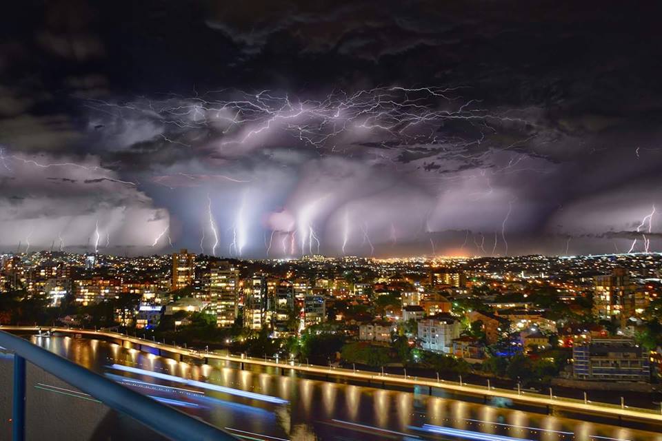
Temperatures in Pretoria are set to soar over the next week and could be accompanied by thunder and lightning storms.
Forecasters from the SA Weather Service on Tuesday said the heat conditions would remain high and in the upper 30s through to the weekend, dipping slightly on Thursday but offering no real relief. Forecaster Christina Theale said Wednesday's minimum temperatures would be 20 ºC and the maximum could hit 37 ºC:
She said a 60 percent chance of rainfall was predicted for Pretoria and the northern region of the province on Friday morning.
Temperatures could be at a low of 20 ºC and reach 34 ºC on Friday. Saturday and Sunday morning are expected to be cooler at 17 C, but will rise to 34 ºC by midday, Theale said.
The country was recently caught in the grip of a severe heatwave, accompanied by dry conditions, which, with the drought, has seen water levels drop very low.
Temperatures at the height of the heatwave last month went as high as 38 ºC and had weather experts predicting that the country would experience the highest temperatures reached in years this summer. The extreme weather conditions are expected to last until the end of the summer in April next year. Theale on Tuesday said there were a lot of hot conditions being experienced across the country, which were expected to spread.
Comment by Mark on December 7, 2015 at 11:46am

The devastation from above: Aerial photographs show widespread flooding across Cumbria caused by Storm Desmond as residents tell of despair after £48million flood defences fail to do their job

http://www.dailymail.co.uk/news/article-3348001/Storm-Desmond-wreak...

Dramatic aerial photographs have revealed widespread flooding devastation in England where more than 1,000 residents have evacuated their homes.
And the shocking scenes in the North West have come despite £48million being spent on flood defences in recent years in a bid to stop such events.
Fury is mounting today over a lack of protection for Cumbria, with the Keswick Mayor criticising the 'completely overwhelmed' defences in his town.
Paul Titley said the defences 'were designed for a one-in-100-year event - and since it's six years since we had the last one, we are sort of surprised'.
Cumbria council leader Stuart Young called today for an investigation into adequacy of flood defences as families said they had not been protected.
Sian Lawson, 46, and her daughter Emilie, 18, suffered £200,000 of damage to their home last time and could not return for seven months.
Fields, homes and even Carlisle United's football ground have been left underwater after rivers burst their banks following the huge amount of rainfall.
And there is more to come, with Met Office severe warnings in place until Thursday - and up to seven inches of rain expected between now and then.
Flooding was so severe in Cumbria that a major incident had to be declared and Army personnel and Chinook helicopters were called in to help.
Police, mountain rescue teams and firefighters were also trying to reach those stranded in their homes, as the water rose to waist-height.
Some 40,000 properties in the North West were still without power this morning, although this figure was down from 60,000 yesterday.
Water supplies in a number of main towns were also affected by flood water and at least 20 schools are expected to remain closed today.

Comment by KM on December 7, 2015 at 3:09am

http://strangesounds.org/2015/12/apocalytical-storm-sweeps-through-...

That’s the most powerful storm in the past 18 years of Paraguay.

The storm hit the capital and surrounding on Friday, December 4, 2015 and killed a boy and a baby. Moreover, drinkable water, electricity were and roads collapsed. The state of Emergency has been declared.

apocalyptical storm paraguay, apocalyptical storm paraguay pictures, apocalyptical storm paraguay video, storm paraguay, largest storm in 18 years in paraguay, most powerful storm in 18 years for paraguay, paraguay insane storm, giant storm engulfs paraguay

The storm mainly affected the capital city and the metropolitan area iss the largest in the last 18 years according to wind and precipitation data.

apocalyptical storm paraguay, apocalyptical storm paraguay pictures, apocalyptical storm paraguay video, storm paraguay, largest storm in 18 years in paraguay, most powerful storm in 18 years for paraguay, paraguay insane storm, giant storm engulfs paraguay

The storm began at 4.20 am. 90 millimeters of rain fell in just two hours and wind speeds reached 100 mph.

apocalyptical storm paraguay, apocalyptical storm paraguay pictures, apocalyptical storm paraguay video, storm paraguay, largest storm in 18 years in paraguay, most powerful storm in 18 years for paraguay, paraguay insane storm, giant storm engulfs paraguay

A teenager and a two-old month baby died in the storm. The young man was squashed by a wall that collapsed on his room. The baby got swept away by the resulting floods.

apocalyptical storm paraguay, apocalyptical storm paraguay pictures, apocalyptical storm paraguay video, storm paraguay, largest storm in 18 years in paraguay, most powerful storm in 18 years for paraguay, paraguay insane storm, giant storm engulfs paraguay

18 landslides have blocked streets and engulfed city buildings.

At least hundred trees were uprooted.

apocalyptical storm paraguay, apocalyptical storm paraguay pictures, apocalyptical storm paraguay video, storm paraguay, largest storm in 18 years in paraguay, most powerful storm in 18 years for paraguay, paraguay insane storm, giant storm engulfs paraguay

A lot of sections of roads and routes were literally destroyed by the waters that swept away everything in its path as seen between San Antonio to Villa Elisa.

Comment by KM on December 5, 2015 at 12:09pm

http://www.theweathernetwork.com/news/articles/records-broken-as-mi...

Records broken as mild conditions persist across Prairies

Friday, December 4, 2015, 4:03 PM - Record warmth was felt across all three Prairie provinces Thursday, with temperatures hitting the upper single digits and there are no signs of cooling down.

A ridge of high pressure across southeastern United States has helped push a southerly flow up into the southern Prairies. Temperatures are about 10 degrees above the seasonal average for many cities.

For instance, Winnipeg's daytime high for Friday is 4C, meanwhile the average this time of year is a cool -8C.

Manitoba shattered 18 temperature records on Thursday, according to Environment Canada. The village of McCreary hit a balmy 10.6C, breaking a record of 7.5C set in 1989. Morden was the second runner up with 9.6C, breaking 7.1C set in 2004.

On Friday, 25 heat records were broken.

Unseasonably warm temperatures are expected to continue for the Prairies into the middle of next week.

While many residents are enjoying the mild December temperatures, a lack of snow has had an impact on many seasonal businesses.

University of Saskatchewan business student Chris Thorimbert and his two friends were hopeful their snow removal business would take off this winter. And he was expecting to see, "A lot more snow than this," Thorimbert told Global News.

"A lot more clients too. But people are kind of shying away just because there's nothing really on the ground," he said. 

Meanwhile, in Saskatoon, snow clearing companies have offered discounts to customers. In 2014, Table Mountain Regional Park kicked off their ski and snowboard season the first weekend of December and with no snow in the foreseeable future, the slopes likely won't open until Dec. 19, Global News reports.

The Weather Network meteorologists suggest El Niño could have an impact this winter, as the phenomenon has a reputation of bringing mild winters across southern Canada.


Comment by KM on December 4, 2015 at 10:37pm

http://www.dailymail.co.uk/news/article-3345578/Get-ready-stormy-we...

Get ready for another stormy weekend! Britain is braced for floods and 80mph winds as snow causes travel chaos across Scotland

  • Yellow 'be aware' warning for strong winds across Scotland, Northern Ireland, and central and northern England
  • The Environment Agency has also issued 27 flood warnings and 89 flood alerts, covering much of the UK
  • Heavy snow fall last night led to road closures across Scotland with gridlock traffic in the worst affected areas

Britain has been told to brace for another stormy weekend with heavy downpours and gales expected to cause widespread disruption.

The Met Office has issued an amber 'be prepared' warning for rain across Scotland, Northern Ireland, and northern England, on both Saturday and Sunday, with the north-west of the country set to experience the first and most severe gusts – measuring between 70 and 80mph.

There is also a yellow-graded warning for rain in place for much of the country north of the Midlands, advising residents to expect more than an inch of rain, with more than two inches on higher ground. And the Environment Agency has issued 27 flood warnings and 89 alerts, covering much of the UK.

Meanwhile, sudden heavy snowfall last night led to road closures across Scotland and had a major impact on key routes through the Borders while downpours across the UK - from Swansea to the Isle of Man - caused chaos for motorists and even saw a school bus crash when a bridge collapsed.

Dramatic pictures show the overturned bus in a river on the Isle of Man after it was forced off the road when a bridge in Laxey collapsed in heavy rain.

Stricken: Dramatic pictures show an overturned school bus in a river on the Isle of Man after it was forced off the road when a bridge in Old Laxey collapsed in heavy rain last night. The driver managed to escape the vehicle unharmed and there were fortunately no others onboard

Stricken: Dramatic pictures show an overturned school bus in a river on the Isle of Man after it was forced off the road when a bridge in Old Laxey collapsed in heavy rain last night. The driver managed to escape the vehicle unharmed and there were fortunately no others onboard

The Rivers Dee in Wales as floods hit the Llangollen Bridge on a day which saw parts of Britain battered by stormy weather

The Rivers Dee in Wales as floods hit the Llangollen Bridge on a day which saw parts of Britain battered by stormy weather

Overturned: Police confirmed the bridge in Laxey remained closed to motorists today and said the stricken school bus is not likely to be recovered until the weekend 'at the earliest' because the salvage operation involves moving overhead power cables and gas pipes

Overturned: Police confirmed the bridge in Laxey remained closed to motorists today and said the stricken school bus is not likely to be recovered until the weekend 'at the earliest' because the salvage operation involves moving overhead power cables and gas pipes

Comment by KM on December 4, 2015 at 4:06pm

http://www.hindustantimes.com/lucknow/in-pics-lucknow-goes-dark-at-...

In Pics | Darkness, showers hit normal life in Lucknow


It was the first time in over a decade that the city witnessed zero visibility on a December afternoon 


Several parts of Uttar Pradesh experienced freak weather on Tuesday afternoon after being hit by sudden dust storm and heavy rainfall.

Lightning claimed seven lives in the state. While a woman and her minor sister died in Auraiyya district, three people perished in Mathura, one in Mainpuri and one in Etah.

Lucknow and Kanpur were plunged into darkness, followed by storm and heavy rain. Allahabad, Agra and some other areas witnessed storm and rain but the intensity was less in comparison to Lucknow and Kanpur.


The unexpected showers and storm threw normal life out of gear and affected vehicular traffic. 


Several trees were also uprooted and there were reports of some people receiving injuries.

Waterlogging and power cuts added to the people’s woes.

Met department director JP Gupta said the weather had changed significantly due to an upper cyclonic air circulation over Madhya Pradesh which had shifted towards UP.


It was the first time in over a decade that the city witnessed zero visibility on a December afternoon. 


Several Lucknow residents took to social media to post updates about the storm. “Never seen such a phenomenon. I had heard about Kaali Aandhi (black storm). Saw it today. 


Comment by KM on December 3, 2015 at 2:03am

https://www.rt.com/news/324223-india-torrential-rains-floods/

Worst in 100 years: Non-stop torrential rains ravage southern India (PHOTOS,VIDEO)

An Indian labourer pushes his cycle trishaw through floodwaters in Chennai on December 1, 2015, during a downpour of heavy rain in the southern Indian city © Strdel
Thousands of people have been evacuated and a rescue operation is under way in Southern India, which has been severely flooded after several days of non-stop torrential rains, which prompted the closure of schools and factories and flight cancelations.

The city of Chennai, capital of the southern Indian state of Tamil Nadu, has been almost cut off from the outside world. According to local media, the rains have set a 100-year-old record in the city, which is home to about 6 million people.

"Heavy rain accompanied by strong winds may make the situation worse in Chennai," the Indian Meteorological Department (IMD) said, adding that the rains may continue for at least four days.

Thousands of people have been forced to flee their homes. The authorities have already canceled all flights and the trains have also stopped running, due to water on the tracks. Chennai International Airport, the fourth busiest in India, will remain shuttered until Thursday, Indian media reported.The Indian Army, Navy and National Disaster Response Force (NDRF) have been deployed in the worst affected areas of the city.

"We have started the rescue operation but the biggest challenge is to find a way to clear the inundated airport and main roads," Anurag Gupta, a senior official at the National Disaster Management Authority in New Delhi said, as cited by Reuters.

Photos and videos of people floating in boats along streets that have turned into rivers have literally flooded social media, with residents helping each other and even rescuing pets. Hundreds of people in less-affected areas have opened their homes for those in need.

Comment by Scott on December 1, 2015 at 8:51am

IBM is supplementing its weather prediction supercomputing with magma flow modeling.

IBM wants to predict earthquakes and volcanoes with Watson (11/23/15)
http://qz.com/556172/ibm-wants-to-predict-earthquakes-and-volcanoes...
Quote: "A team of computer scientists at IBM, in partnership with researchers from the University of Texas at Austin, New York University and the California Institute for Technology, created a model that simulated the entire flow of mantle under the Earth’s surface. ... IBM is working with the US Department of Energy on this model, as well as its work on attempting to predict the weather. The company also recently bought most of the assets of Weather Company—the owners of the Weather Channel—including its myriad weather sensors around the world."

See ZetaTalk: Heralding
http://www.zetatalk.com/poleshft/p24.htm
All attempts to explain the changes based on Global Warming from the Greenhouse effect will run into snags as the weather will refuse to be predictable. Areas of the world which have been deserts throughout mankind's memory will become swamps under constant and repeated rains. Temperate climates used to periodic gentle rainfall will suffer intractable droughts. Then this will switch about, for no apparent reason. The reason lies deep within the Earth's core, an area the meteorologists refuse to consider, and thus their predictions on the atmosphere will never be based on the right parameters.

Also:
Weather Predictions
http://www.zetatalk.com/index/blog1005.htm

Weather Channel Depicts Planet X/Passage (NEW ZetaTalk)
http://poleshift.ning.com/profiles/blogs/weather-channel-depicts-pl...

Comment by KM on December 1, 2015 at 2:23am

http://strangesounds.org/2015/11/terrifying-green-storm-clouds-engu...

Terrifying green storm clouds engulf Brisbane, Australia in apocalyptical scenery

Look at these terrifying green storm clouds engulfing Brisbane, Queensland on November 29, 2015.

And I am pretty surprised that no tornadoes have been reported.

Green clouds are often associated with extreme weather phenomena such as tornadoes – in the Great Plains region of the U.S. – or apocalyptic... in large thunderstorms – in Queensland.

Well, yesterday on November 29, 2015, terrifying greens storm clouds engulfed the sky of Brisbane and surrounding areas in southeast Queensland, Australia. Pictures are just insane. Enjoy…

terrifying clouds brisbane storm november 2015, brisbane storm november 29 2015, green clouds brisbane storm november 29 2015, apocalyptic storm brisbane november 2015, terrifying clouds engulf brisbane november 2015, brisbane storm pictures, insane storm destroys brisbane november 2015 picture, insane cloud brisbane storm 2015, green cloud storm brisbane november 29 2015 pictures

Comment by KM on December 1, 2015 at 2:10am

http://m.thejakartapost.com/news/2015/11/30/floods-landslides-hit-w...

Floods, landslides hit West, North Sumatra, cut off access

Torrential rain has caused landslides in parts of West and North Sumatra, cutting off access and disrupting economic activity. 

A 150-meter stretch of the highway connecting West Sumatra and Riau in Jorong Sopang, Pangkalan Koto Baru, Limapuluh Kota regency, was engulfed by up to a meter of floodwater on Sunday at 5 a.m. local time.

Limapuluh Kota Disaster Mitigation Agency (BPBD) head Nasriyanto said the flooding was triggered by the overflowing Batang Manggilang River.

“Only large trucks were able to pass, resulting in other vehicles from Pekanbaru and Payakumbuh backing up 2 kilometers for eight hours,” Nasriyanto told The Jakarta Post on Sunday. 

He said the heavy rain that had drenched the region in the past three days had triggered floods and landslides in a number of locations in the regency. At least 500 homes were engulfed by over 50 centimeters of floodwater and eight homes were reportedly damaged by a landslide on Sunday morning.

“We, together with residents, are currently moving residents and livestock to safer areas. Reports are coming in, but no casualties have been reported so far,” said Nasriyanto.

Floods have taken place in Taram and Sarilamak villages in Harau district, Payakumbuh, Guguk, Lareh Sago Halaban and Kapur Sembilan districts. 


SEARCH PS Ning or Zetatalk

 
Search:

This free script provided by
JavaScript Kit

Donate

Donate to support Pole Shift ning costs. Thank you!

© 2024   Created by 0nin2migqvl32.   Powered by

Badges  |  Report an Issue  |  Terms of Service