Volcano watch
Japan: A new island appears in the Ogasawara Islands - November 2013
Active volcanoes (Sep 28, 2012)
"Of course all volcanoes will explode, as this is going to be a very severe pole shift. What about the months and years preceding the pole shift? It is no secret that Mammoth Lake and the caldera of Yellowstone are warming up, and the populace has been prepared for these occurrences by the movie Volcano where there, in the middle of LA, lava is bubbling up. In fact, there is a fault line running from the approximate San Diego/LA area, up into the Sierras, and this is liable to rupture rather violently during one of the quakes that precedes the pole shift by some months. Volcanic eruptions from that area in the Sierras can be expected. Will Mount St. Helen erupt? All volcanoes that have been active within the memory of man will begin spewing and burping and oozing, and many that were not expected to become active will reactive. " ZetaTalk - Feb 15, 2000
Views: 218041
Comment
-
Comment by Sevan Makaracı on October 4, 2011 at 3:08pm
-
-
OCT 3 :
Hawaii, Kilauea volcano - Lava flows vigorously advancing east of Pu`u `O`o; gas emissions elevated.
-
-
OCT 3 :
Explosive eruptions at Sakurajima volcano, Japan :
Couple explosive eruption have been recorded at Sakurajima volcano in Japan....
-
-
OCT 3 :
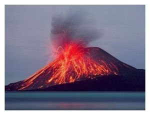
Indonesia, Anak Krakatau - New eruption
A new eruption occurred at Anak Krakatau yesterday (3 Oct). A large (2-3 km high) ash cloud was seen rising from the volcano observatory on Java's west coast and is seen in a news TV video.
The eruption followed an unusual seismic crises that had started 30 Sep and produced more than 5700 quakes recorded in a few days.VIDEO : http://www.metrotvnews.com/read/newsvideo/2011/10/03/137085/Aktivit...
-
Comment by Andrew Veresay on October 3, 2011 at 5:11pm
-
http://en.wikipedia.org/wiki/Krakatoa
Eruptions at the volcano (Krakatoa) since 1927 have built a new island in the same location, named Anak Krakatau (which is Indonesian for "Child of Krakatoa").
-
-
The 1883 eruption of Krakatoa is the second greatest volcanic eruption in recorded history (after Mount Tambora, only 68 years earlier), erupting more than 18 cubic kilometers of tephra in less than 48 hours, and killing about 36,500 people.
Now we've got it raised to its highest alert status...
-
-
this could be a sign that Indonesia goes off soon (under the waves)...
-
-
Indonesia: Anak Krakatau Raised To Highest Alert Status- Quakes Are Now Continuous, Warn Officials
October 2, 2011Indonesian officials have raised the status of one of its most dangerous volcanoes, Anak Krakatau, to a "standby" or level IV- the highest level.
The Center for Volcanology and Geological Hazard Mitigation (PVMBG), Surono said this is a rise in status that was set on Friday, September 30, 2011 evening at 24.00. The reason for the elevated status is because of the high-intensity level of earthquakes.
Today, for example. "On October 2, 2011, at 00.00 until 12.00, there are 2745 recorded seismic events," said Surono, when he was contacted by VIVAnews.com, Sunday, October 2, 2011. Earthquakes under Mount Anak Krakatau, Surono added, were even felt all along the island of Anak Krakatau.
"The swarm of tremors are continuous and although small, 2 on the Richter scale, they are cause for concern because they are felt constantly," he added. He explained, almost since 2007, Krakatau has been stirred by unrest. "In a moment, it stopped, and erupted in 2009. I think this mountain is always in danger of erupting," he added. - Viva News (translated)
http://www.sott.net/articles/show/235772-Indonesia-Anak-Krakatau-Ra...
http://us.nasional.vivanews.com/news/read/251927-ribuan-kali-gempa-...
-
-
SEP 30 :
Costa Rica's Rincon de la Vieja Volcano Awakens
Dormant for more than a decade, the Rincon de la Vieja volcano surprised area residents and tourists with its a phreatic eruption last August 19 and then again on September 16 and 22.
The volcano is located in the northern sector of the country Buenos Aires de Aguas Clara de Upala, in the province of Alajuela.
Experts from the Observatorio Vulcanológico y Sismológico de Costa Rica OVSICORI) toured the Rincon de la Vieja Volcano to inspect activity.
The ascent to the crater took over three hours until it was confirmed what the neighbors reported, investigators finding that on Saturday, September 17, a day after the eruption of water and sediment, some fish were found dead in the river Penjamo.
Investigators this week found more evidence of material spewed by the colossus in the streams and ditches in the area.
The neighbuors report indicated that some sediment have made up t 18 kilometres upstream in the local rivers.
Also being investigated is whether the walls of the volcano have some movement.
Most phreatic eruptions are concentrated in the centre of the lagoon that borders the walls that are 75 metres high.
The eruption of November 1995 was one of the most intense. And although the current eruptions are nothing compared, area residents are taking precautions.
After a meeting with experts hey took the decision to revive the local emergency committee. For now, tourist visits to the crater have been suspended and guides are required to visit other parts of the national park.
Authorities recommend people living in the foothills of the Rincon de la Vieja be aware of the water level in the rivers.
http://www.insidecostarica.com/dailynews/2011/september/30/costaric...
--------------------------------------------------------------
Sep 30, 2011 (The Tico Times - McClatchy-Tribune Information Services via COMTEX) --
It's been a busy month for Rincon de la Vieja Volcano in the northwestern province of Guanacaste. The Volcanological and Seismological Observatory of Costa Rica (Ovsicori) reports that since Sept. 9 the volcano has erupted twice and caused substantial fish kills in nearby rivers.
Residents of nearby Buenos Aires de Upala reported a minor eruption of the volcano on Sept. 16 that spit ash and other materials into the air. That eruption also released a mass of hot, gray liquid that poured out of the crater along with smoke and vapors. On Sept. 17, dead fish floated in the waters of the nearby Penjamo River, which ran milky with volcanic sediment, according to Ovsicori reports.
A second, similar eruption occurred Sept. 22. The daily La Nacion reported that this eruption caused the Environment, Energy and Telecommunications Ministry (MINAET) to restrict access to the volcano's crater.http://www.menafn.com/qn_news_story.asp?storyid={7b585c54-7871-4d4d-ac0b-215307b37f7b}
-
-
SEP 29 :
Eruption on Nabro volcano continues / Evidence of ongoing activity (satellite pictures)
Nabro is an Eritrean volcano with NO historic eruption record. Satellite imagery suggests that the eruption of Nabro Volcano, which began in June 2011, continues. The volcano is located on the edge of the Danakil Desert, a remote and sparsely populated area on the border between Eritrea and Ethiopia, and few eyewitness accounts of the eruption are available. Orbiting instruments such as the Advanced Land Imager (ALI) aboard Earth Observing-1 (EO-1), which acquired these images, may be the
only reliable way to monitor Nabro.The images show the volcano in false-color (first) and natural-color (lower second) on September 28,
2011. Heat from vents in Nabro’s central crater is visible as a red glow in the false-color image. Another hotspot about 1,300 meters (4,600 feet) south of the vents reveals an active lava flow. A pale halo
surrounding the vents indicates the presence of a tenuous volcanic plume. South of Nabro’s crater, the dark, nearly black areas are coated with ash so thick it completely covers the sparse vegetation. On either side of this region is a thinner layer of ash with some bright green vegetation (exaggerated in false-color) poking through. In the natural-color image, the arid landscape is light brown where it is not
covered by ash. The ash is black, while a fresh lava flow, spewed out in the last two weeks of June, is dark brown. More fresh lava flows surround the active vents. On either side of Nabro’s caldera, ephemeral
streams have washed away the ash, leaving light-colored channels behind—a first sign of the erosion that will reshape, and eventually remove, what the eruption built.http://earthquake-report.com/2011/09/29/nabro-volcano-eritreaethiopia-evidence-of-ongoing-activity-satellite-pictures/
http://www.irishweatheronline.com/news/earth-science/geology/erupti...
© 2024 Created by 0nin2migqvl32.
Powered by
![]()
You need to be a member of Earth Changes and the Pole Shift to add comments!
Join Earth Changes and the Pole Shift