Please Place Evidence of the 7 of 10 Plate Movements Here
Kojima had created small snips of Konstantin's animation of the 7 of 10 Plate Movements.
Here is the full 7 of 10 Animation by Konstantin.
This blog is the place to document ongoing earth changes related to the 7 of 10 plate movements as described by the Zetas.
ZetaTalk: 7 of 10 Sequence
written October 16, 2010
The 7 of 10 scenarios describe plate movements, and for this to occur something has to release the deadlock, the current stalemate where the plates are locked against each other. Once the deadlock is broken and the plates start moving, sliding past each other, new points where the plates are locked against each other develop, but these are weaker locks than the one at present. The current lock, as we have so often stated, is the Indo-Australian Plate which is being driven under the Himalayans. This is no small lock, as the height of the Himalayans attests. Nevertheless, the activity in this region shows this likely to be the first of the 7 of 10 scenarios to manifest. Bangladesh is sinking and the Coral Sea is rising, showing the overall tipping of the Indo-Australian Plate. Now Pakistan is sinking and not draining its floods as it should, while Jakarta on the tongue of Indonesia is also sinking rapidly, showing that the tilt that will allow Indonesia to sink has already started.
Meanwhile, S America is showing signs of a roll to the west. Explosions on islands just to the north of the S American Plate occurred recently, on Bonaire and Trinidad-Tobago, and the Andes are regularly being pummeled. There is a relationship. As the Indo-Australia Plate lifts and slides, this allows the Pacific plates to shift west, which allows S America to shift west also. This is greatly increased by the folding of the Mariana Trench and the Philippine Plate. But it is the Indo-Australian Plate that gives way to incite change in these other plates, and this is what is manifesting now to those closely following the changes. Once the folding of the Pacific has occurred, Japan has been destabilized. We are not allowed to give a time frame for any of these plate movements, but would point out that it is not until the North Island of Japan experiences its strong quakes that a tsunami causing sloshing near Victoria occurs. There are clues that the New Madrid will be next.
Where the N American continent is under great stress, it has not slipped because it is held in place on both sides. The Pacific side holds due to subduction friction along the San Andreas, and the Atlantic side holds due to the Atlantic Rift's reluctance to rip open. What changes this dynamic? When S America rolls, almost in step with the folding Pacific, it tears the Atlantic Rift on the southern side. This allows Africa freedom to move and it rolls too, dropping the Mediterranean floor above Algeria. What is holding the N American continent together has thus eased, so that when the Japan adjustments are made, there is less holding the N American continent in place than before, and the New Madrid gives way. We are also not allowed to provide the time frame between the Japan quakes and New Madrid. Other than the relationship in time between the New Madrid and the European tsunami, no time frame can be given. The sequence of events is, thus:
- a tipping Indo-Australia Plate with Indonesia sinking,
- a folding Pacific allowing S America to roll,
- a tearing of the south Atlantic Rift allowing Africa to roll and the floor of the Mediterranean to drop,
- great quakes in Japan followed by the New Madrid adjustment,
- which is followed almost instantly by the tearing of the north Atlantic Rift with consequent European tsunami.
Source: http://www.zetatalk.com/index/zeta584.htm
Tipping Indo-Australia Plate with Indonesia sinking,
http://zetatalk.com/7of10/7of10-23.htm
http://zetatalk.com/7of10/7of10-24.htm
http://zetatalk.com/7of10/7of10-25.htm
http://zetatalk.com/7of10/7of10-26.htm
http://zetatalk.com/7of10/7of10-28.htm
http://zetatalk.com/7of10/7of10-30.htm
http://zetatalk.com/7of10/7of10-31.htm
http://zetatalk.com/7of10/7of10-32.htm
http://zetatalk.com/7of10/7of10-34.htm
http://zetatalk.com/7of10/7of10-37.htm
Folding Pacific
http://zetatalk.com/7of10/7of10-33.htm
http://zetatalk.com/7of10/7of10-38.htm
http://www.zetatalk.com/info/tinfx351.htm
http://zetatalk.com/7of10/7of10-47.htm
South American Roll
http://zetatalk.com/7of10/7of10-39.htm
http://zetatalk.com/7of10/7of10-40.htm
http://zetatalk.com/7of10/7of10-41.htm
http://zetatalk.com/7of10/7of10-42.htm
http://zetatalk.com/7of10/7of10-43.htm
http://zetatalk.com/7of10/7of10-44.htm
http://zetatalk.com/7of10/7of10-45.htm
http://zetatalk.com/7of10/7of10-47.htm
African Roll
http://www.zetatalk.com/7of10/7of10-46.htm
http://zetatalk.com/7of10/7of10-47.htm
http://zetatalk.com/7of10/7of10-48.htm
http://zetatalk.com/7of10/7of10-52.htm
Japan Quakes
http://www.zetatalk.com/7of10/7of10-53.htm
http://zetatalk.com/7of10/7of10-54.htm
New Madrid
http://www.zetatalk.com/7of10/7of10-59.htm
http://www.zetatalk.com/7of10/7of10-60.htm
http://zetatalk.com/7of10/7of10-61.htm
http://www.zetatalk.com/7of10/7of10-62.htm
http://zetatalk.com/7of10/7of10-63.htm
http://zetatalk.com/7of10/7of10-64.htm
http://zetatalk.com/7of10/7of10-65.htm
http://zetatalk.com/7of10/7of10-68.htm
European Tsunami
http://zetatalk.com/7of10/7of10-70.htm
http://zetatalk.com/7of10/7of10-71.htm
http://zetatalk.com/7of10/7of10-72.htm
http://zetatalk.com/7of10/7of10-73.htm
http://zetatalk.com/7of10/7of10-74.htm
Due to the slowing of the 7 of 10 plate movements by the Council of Worlds the impact of some of the events described above will be lessened.
The Zetas explain:
ZetaTalk: Pace Slowed
Written May 19, 2012
The effect of the thousands of humming boxes placed along fault lines and plate borders can be seen in several incidents that have occurred since the start of the 7 of 10 plate movements. The lack of tsunami during the 7 of 10 sinking of the Sunda Plate is one such example. We predicted at the start of the 7 of 10 scenarios in late 2010 that the Sunda Plate sinking would occur within 2-3 weeks, yet it dragged on through 2011. At the time we had predicted tsunami on the Sunda Plate, in general equivalent in height to the loss of elevation for a coastline. None of this occurred due to the slower pace.
The pace of mountain building in S America, where slowed, has still resulted in rumpling up and down the Andes, and stretch zone accidents likewise in lands to the east of the Andes. The shape of S America has clearly changed. Will the islands in the Caribbean be spared? At some point, as with the magnitude 7.9 quake in Acapulco on March 2, 2012 a significant adjustment will need to occur, and this will include depressing the Caribbean Plate so it tilts, sinking the islands and lands on that portion of the plate to the degree predicted. But the S American roll will likely continue to avoid the magnitude 8 quakes we originally predicted in deference to slow rumpling mountain building. The African roll was anticipated to be a silent roll in any case, so the slowed pace would not affect the outcome.
Will the slowed pace prevent the 7 of 10 scenarios for the Northern Hemisphere? Bowing of the N American continent has reached the point of pain, with breaking rock booming from coast to coast, but still there have been no significant quakes in the New Madrid area. Yet this is past due, and cannot be held back indefinitely. What has and will continue to occur for the Northern Hemisphere scenarios are silent quakes for Japan, which has already experienced drastic subduction under the north island of Hokkaido where mountain building is occurring as a rumple rather than a jolt. However, the anticipated New Madrid adjustment cannot be achieved without trauma. But this could potentially occur in steps and stages such that any European tsunami would be significantly lessened.
All rights reserved: ZetaTalk@ZetaTalk.com
Source: http://www.zetatalk.com/7of10/7of10109.htm
ZetaTalk , Written March 10, 2012
What happens when the pace of plate movement is slowed? The likelihood of tsunami is definitely reduced, as can be seen in the sinking on the Sunda Plate. The sinking occurred, and is almost complete, yet the possibility of tsunami we predicted for various regions on the Sunda Plate were avoided. The height and force of a tsunami is directly related to the degree of displacement in the sea floor, and if this happens in steps rather than all at once the displacement will be less for any given step.
This bodes well for the European tsunami. If the Council of Worlds is still imposing a slower pace on the 7 of 10 plate movements, this tsunami will definitely be lessened. The tear in the North Atlantic will be slight, each time. The amount of water pouring into this void will be less, each time. And the rebound toward the UK will likewise be less, each time. But our prediction is the worst case situation, and it also reflects what the Earth changes, unabated, would produce.
But what does a slower pace do to land masses where jolting quakes are expected? Does this reduce the overall magnitude of the quakes anticipated? Large magnitude quakes result when a catch point along plate borders is highly resistant, but snapping of rock finally results. Usually there is one place, the epicenter, where this catch point resides and a long distance along the plate border where smaller quakes have prepared the border for easy movement. A point of resistance within the body of a plate, such as the New Madrid, can likewise resist and suddenly give.
There is no way to lessen the resistance at these catch points, though the tension that accompanies such points can be reduced so that the quake itself is delayed. What this means for a slower 7 of 10 pace is that large magnitude quakes will be spread apart in time, and their relationship to our predictions thus able to be camouflaged by the establishment. Where sinking (such as the Caribbean Island of Trinidad) or spreading apart (such as to the west of the Mississippi River) are to occur, these land changes will eventually arrive. But like the sinking of the Sunda Plate, a slower pace unfortunately allows the cover-up time to maneuver and develop excuses.
All rights reserved: ZetaTalk@ZetaTalk.com
Views: 117182
Comment
-
Comment by Stanislav on March 25, 2016 at 5:41pm
-
Vietnam
Highlights
- Since January, severe drought and saltwater intrusion has significantly affected the livelihood, food security and water supply of nearly 1.8 million people across all provinces in SouthCentral,
- Central Highlands and Mekong Delta regions.
- To date, 39 out of 63 provinces in Vietnam have been impacted by drought – 12 provinces declared a State of Emergency.
- The Ministry of Agriculture and Rural Development, United Nations and NGOs partners are conducting a joint multi-cluster rapid assessment to inform response planning. Findings are expected to become available around 1 April.
- On 15 March, the Ministry of Agriculture and Rural Development organized a development partners meeting on the drought situation in the south of Viet Nam where situation from three affected provinces were discussed. As an outcome of this meeting, the Government, UN and INGOs decided to carry out a multi-cluster rapid assessment to better understand the immediate needs of the affected provinces.
- 1.75 million People affected by the drought and saltwater intrusion
- 39 Number of provinces affected
- 12 Provinces in state of emergency
- 226,094 hectares productive land affected
Situation Overview
Since late 2014, a serious drought has been impacting the South Central Coast, Central Highlands and Southern regions of Vietnam. Lower than average rainfall and very high temperatures throughout 2015 further exacerbated the situation. In the first half of 2015, nine provinces were seriously affected in the South Central Coast, Central highlands and Southern Vietnam (Quang Tri, Binh Dinh, Khanh Hoa, Ninh Thuan, Dak Lak, Dak Nong, Gia Lai, Nghe An, Kon Tum). Among these, three provinces declared the emergency situation in June 2015 (Ninh Thuan, Binh Thuan and Nghe An).
For the past three months, the ongoing drought, water shortage and salt intrusion have posed a significant risk to some 1.75 million people in the South-Central regions, Central Highlands and Mekong Delta regions of Vietnam. A total of 39 out of the 63 provinces (62 per cent) of Viet Nam have been affected and 12 provinces have declared a State of Emergency (Binh Thuan, Ben Tre, Vinh Long, Soc Trang, Ca Mau, Tra Vinh, Tien Giang, Long An, Gia Lai, Kon Tum, Ninh Thuan, Kien Giang).
As of 17 March, the upstream water level of the Mekong River is reported very low (water level on Tien River in Tan Chau was 0.31 metre; water level on Hau River in Chau Doc was 0.54 metre). It is expected that the water flow in rivers in the Central Region will continue to decrease until the end of June.
The drought is attributed to saline (salt) intrusion in the Mekong Delta affecting aquifers (underground water sources) which usually supports the domestic water demand.
Average capacity of medium and big reservoirs have also reached low capacities; some reservoirs are at 60 to 70 per cent of their full design capacity. At least four reservoirs (Da Ban, Song Bieu, Lanh Ra and Da Bac) have reached considerably low levels as of 15 March. According to national weather forecasts, there is a 90 per cent probability that effects of El Niño will continue until mid-2016.
Source: reliefweb.int
-
-
22 families displaced after land sinks in Batote, India. 22 March, 2016.

Many villages without power, DC assures all possible help
Twenty two (22) families in Batote town today abandoned their homes after the area witnessed land sinking due to heavy rainfall across the district.
Three-days of heavy rainfall resulted in total collapse of 16 houses at Sheikh Mohalla in Batote whereas four other houses were partially damaged.
The residents of these houses had luckily shifted from these structures before they collapsed.
The houses belonging to Mangtu Sheikh, Ghulam Hussain, Mohammad Naseem, Samdu Sheikh, Dilawar Mohammad, Altaf Hussain, Vishwa Nath Mattu, M Yasin, M Farooq, M Issac, M Naseem, M Shabir, Mohammad Lateef, Shakil Ahmed, Zaiba Begum and Mohammad Yousuf have been damaged beyond repair.
The houses of Roshan Lal Mattu, Nirmal Kour, M Rafiq and Mohammad Lateef have been partially damaged.
Taking stock of the situation, district administration has provided 15 tents and 75 blankets to the landslide victims, besides ordering to supply one month free ration to these families.
Owing to the ongoing sinking of land over one kilometre stretch on which the 11KV transmission line runs also has been damaged.
The damage has caused power failure in Tringla, Amar Cheshma, Ladhwal, Khotri, Barthal and Bhandera.
These places are without electricity from Saturday night.
Deputy Commissioner (DC) Bashir Ahmed Dar while offering every possible help to the sufferer, asked them to hire house on rent, “which will be paid by the administration”. Source: risingkashmir.com
-
-
Southeastern U.S. strech zone
Landsat 8
13 March, 2016. Click to view full resolution
10 February, 2016. [Source: earthexplorer.usgs]
17 March, 2016. FEMA official: Unprecedented Louisiana flooding affecting many uninsured, but federal help available
The damage and scope of last week’s flooding across Louisiana has been both record breaking and in many ways unprecedented, Gov. John Bel Edwards reiterated in a news conference on Thursday where he was joined by the top federal disaster recovery administrator in the country.
But to make matters worse, many of the people impacted by the recent rising waters didn’t have insurance because floods had never before touched their properties.
“This is a record-breaking flood event with floodwater all over the state of Louisiana, reaching places it’s never been before,” Edwards said.
Federal Emergency Management Agency Administrator Craig Fugate, in town from Washington, D.C., said authorities are working to assist people in need as quickly as possible. To date, he said $2.5 million has been paid out in flood insurance claims.
So far, officials have identified about 12,000 homes with reports of water damage across the state. Another 1,200 private residences, which make up second homes or businesses, and 13 public facilities, including Grambling State University and Southeastern Louisiana University, had damage from flooding.
Of those, only 3,600 flood insurance claims have been filed in Louisiana.
But all of these numbers are expected to grow, as officials are still calculating the damage and waters in some areas have yet to recede.
“We know some people’s homes are still underwater,” Fugate said. “Other areas are still at risk.”
So far, 26 parishes have been added to the list of federally declared disaster areas, and 11 more are being monitored to determine if they should be added. The declaration means residents and businesses are eligible for federal disaster aid.
The most recent additions were Allen, Ascension and Calcasieu parishes, which, alone, had some 900 homes damaged by high water, Edwards’ office said Wednesday.
<...>
“I spoke to a couple hundred home owners, and very few of them had flood insurance,” Edwards said. “I was in Merryville on Sunday and met a couple who was 86 years old. They’d lived in their home for 50 years and never had water approach their home before, but their home was probably totally destroyed by this particular incident.”It was a sentiment echoed by the Washington Parish Director of Homeland Security and Emergency Preparedness Thomas Thiebaud. Source: theadvocate.com
Indonesia
17 March, 2016. Bandung floods considered worst in 10 years
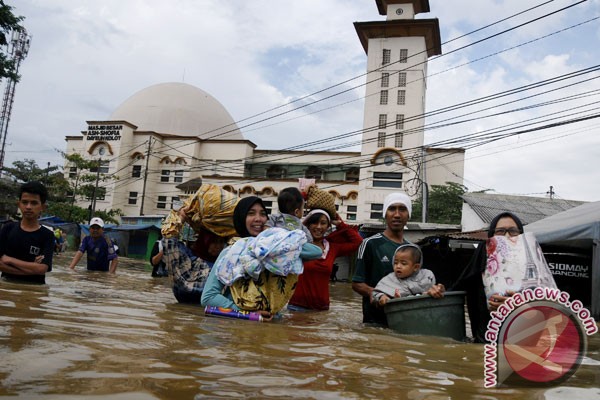
South Bandung area again hit by flooding due to overflowing Citarum River and intensity of heavy rainfall. (FOTO ANTARA / Novrian Arbi)
Floods have spread to wider areas across Indonesian provinces in the last few weeks, with the worst flood striking early this week in Bandung District, West Java Province.
The Bandung floods have left two dead and three missing, as the Citarum River overflowed following incessantly heavy rains, which began March 8.
The downpours caused flooding in 15 regions in Bandung District, Sutopo Purwo Nugroho, spokesman of the National Disaster Mitigation Agency (BNPB), said in a statement on March 13.
Social Affairs Minister Khofifah Indar Parawansa and West Java Governor Ahmad Heryawan visited flood victims on March 14. The minister inspected a public kitchen set up to feed the victims, to ensure that it had adequate supplies.
The flood-affected regions include Cicalengka, Rancaekek, Cileunyi, Solokan Jeruk, Majalaya, Ciparay, Baleendah, Dayeuhkolot, Bojongsoang, Pameungpeuk, Banjaran, Arjasri, Cangkuang, Katapang and Kutawaringin.
The flooding forced more than 8,000 people to evacuate to higher grounds, while submerging over 35,000 homes, and affected some 5,900 families, comprising 24,000 people.
The floodwaters reached a height of between 80 cm to three meters, particularly in villages near the river bank.
The dead victims included a 13-year-old teenager and a mother aged 40 years old, whose husband and two daughters were reported missing after being swept away by the flash flood.
The downpours also triggered a landslide that seriously damaged a house in the Lemburkebon area, Padasuka village, Kutawaringin Sub-district, Bandung.
Further, the major floods that ravaged Bandung have caused large losses to industries.
The current flooding was the worst to have occurred over the past few years and have caused larger losses than earlier floods, Chairman of the Indonesian Businessman Association (Apindo) of the West Java chapter Deddy Wijaya stated on March 15. <...>
Additionally, flooding caused losses to shop owners and the banking business.
"This flooding is the worst over the past 10 years. The floodwaters have reached a height of up to 3.3 meters," Coordinator of Bandungs Disaster-Alert Youth said on the phone recently.
The office of Dayeuhkolot Sub-district administration, which has not been flooded in 20 years, was inundated to a height of 35 cm this year, he said.
BNPB Chief Willem Rampangilei supervised the evacuation of the natural disasters victims. They were housed in local government offices, schools and mosques.
Earlier, on March 2, The BNPB chief told the media that floods and landslides had struck 260 districts and municipalities in the country from January 1 to February 25, leaving 46 people dead and 16 others injured.
The natural disasters also forced the evacuation of 1,083.104 people, Willem Rampangilei said at the press conference.
The government has made efforts to minimize damage from floods and landslides by holding coordination meetings, familiarizing the public with potential natural disasters, developing contingency plans, strengthening logistics, declaring alert status, and providing relief aid, he said.
"When a flood happens, we must first focus on searching and rescuing victims, evacuating refugees and meeting their needs," he said.
To support emergency rescue operations, meet emergency needs and finance emergency repairs of damaged facilities, the government has set aside Rp3 billion in funds.
"The funds have been distributed among the districts of Aceh Utara, Solok Selatan, Solok, 50 Kota, Kampar, Rokan Hulu, Medan, Binjai, Merangin, Bungo, Indramayu, and the province of Bangka Belitung. Each of the regions received Rp250 million," Willem said.
In addition to Bandung, floods have recently struck three sub-districts in Sukabumi District, as well as in West Java, leaving a number of buildings damaged.
In Ketapang District, West Kalimantan Province, three sub-districts -Nanga Tayap, Sandai and Sungai Laur- were also inundated beginning March 10. The flooding is believed to be as bad as in 2010, has affected thousands of local inhabitants.
Floods also inundated thousands of houses in ten villages in Tangerang District of Banten Province on March 13.
The high intensity rain caused the local Cimanceuri River to overflow its banks and sent floods throughout the region, Head of Regional Disaster Mitigation Agency of Tangerang Teteng Jumara said.
In Sampang, Madura Island, East Java Province, floods submerged 12 villages, as the Kalikemuning River spilled over its bank last week.
"The present flooding is the worst," Head of the Sampang Disaster Mitigation Agency Wisno Hatono said recently.
Additionally, harvest failures were feared over 1,083 hectares of rice fields in Sampang.
Floods inundated 7,199 hectares of paddy fields in Riau and over 1,000 hectares in Jambi on Sumatra Island.
In the capital city, despite the Jakarta administration�s efforts to normalize sewage systems, floods reaching a height of up to 120 cm and inundated 20 neighborhoods in early February this year.
Following a recent finding of a large amount of cable jackets in waterways on Merdeka Selatan Road, Central Jakarta, Governor Basuki Tjahaja Purnama (Ahok) voiced his suspicion about sabotage.
Ahok suggested recently that it demonstrated an attempt by unknown persons to engineer floods and he reported the case to police, the Jakarta Post reported.
Jakarta Police Chief Insp. Gen. Tito Karnavian said the police had yet to conclude that the cable jackets were a form of sabotage.
On March 11, Tito announced that six scavengers were detained for allegedly stealing copper and tin inside the cables, believed to have belonged to the State Electricity Company (PLN) , and they left the cable jackets inside the sewers, Tempo.co reported. Source: antaranews.com
-
-
15 March, 2016. Texas town soaked by worst flooding in over a century

In this aerial photo, a boat travels past a home submerged in floodwaters from the nearby Sabine River following recent heavy rains, Tuesday, March 15, 2016, in Deweyville, Texas. (Brett Coomer/Houston Chronicle via AP) MANDATORY CREDIT. Source: abcnews.go.com
Floodwaters are getting deeper in the Deep South. No place has been hit harder than Deweyville, Texas, on the Louisiana border.
It is the worst flooding Deweyville has seen in over 100 years. Everything -- the sheriff's department, post office, church, school, and the town's only grocery store -- is under water.
Deweyville, a town of 1,100 people, sits west of the Sabine River. It's a funnel for many smaller tributaries carrying water downstream from three larger bodies of water. Source: cbsnews.com
16 March, 2016. Disastrous flooding continues to swamp Texas, Louisiana
Record-high floodwaters continued to swamp parts of Texas and Louisiana on Wednesday as the region's slow-motion disaster drifted farther downstream.
The swollen Sabine River, which lies on the boundary between the two states, crested late Tuesday at an all-time record 33.24 feet in swamped Deweyville, Texas, according to National Weather Service meteorologist Tim Humphrey.
<...> In north-central Louisiana, the Red River in Alexandria could hit its highest level in more than 70 years this weekend. The river is forecast to crest at 40.5 feet Sunday. That would be the highest since a 40.65 crest on May 9, 1942. It has not topped 40 feet since 1958.
"This is the third time within a year that we've had a significant high water event," said Blake Cooper, executive director of the Central Louisiana Regional Port. "It's devastating to the river." Source: usatoday.com
-
-
16 March, 2016. Salt-water attacks Can Tho for the first time
Nearly 100 km away from estuary, Can Tho – the largest city in the Mekong Delta – is still affected by salty water as saline intrusion is the worst in decades in Vietnam’s southwestern region.
The Office for Climate Change Affairs has reported that the salinity in the Hau River in Cai Cui port (Cai Rang District, Can Tho City), on March 11 was measured at above 2,000 mg per liter (2‰).Salinity is reducing but it is forecast to increase again in one month.
In the southwestern region, only Dong Thap province, in the upstream Tien River and Hau rivers, has not been attacked by saltwater. Source: english.vietnamnet.vn
-
-
Saltwater intrusion mapping in Mekong Delta (as of end Feb 2016). Rice production lost/affected due to drought and salinity in the Mekong Delta

Source: vnexpress.net; reliefweb.int Vietnam Consolidated Report on Drought and Saltwater ...
-
-
15 March, 2016. Drought affects 39 out of 63 provinces in Vietnam, UN says
UN officials in Vietnam have warned that "severe drought and salt intrusion in the Mekong Delta is affecting" 39 out of 63 provinces in Vietnam, UN spokesman Stephane Dujarric said here Monday.
As of March 10, an estimated 195,200 families did not have sufficient water supply to meet their daily needs, Dujarric said at a daily news briefing here. "Some 10 provinces have declared a state of emergency."
According to the authorities, 159,000 hectares of rice paddy have also been lost, amounting to an economic loss of 10.5 million U.S. dollars, and an additional 500,000 hectares were at risk of being lost by mid-2016, he said. <...> Source: shanghaidaily.com
-
-
Strech zone, Sinking feeling. South east U.S. sinking
Severe flooding in Louisiana. Associated USA flood around Gulf of Mexico with 7 of 10? I do not know why but I think it is a loss of height. [and from another] http://www.disasternews.net/news/article.php?articleid=4510 Flood waters submerged parts of southern Louisiana Tuesday after heavy rains caused flash flooding and forced hundreds of rescues. The National Weather Service estimated 12 to 18 inches of rain fell across the region, with totals reaching up to 20 inches in some areas. Among the hardest hit areas in Lafayette Parish was Carencro, where reports indicated water was as high as high as 8 feet on some roads.
Just as the bowing in the S American Plate has produced stretching and consequent sinking in the swath of land from Rio to Buenos Aires, the bowing in the N American Plate has produced stretching and consequent sinking along the eastern seaboard and land bordering the Gulf of Mexico. Stretched land has only so many options. It can rip open to form a crevasse or a landslide or a sinkhole, or rock layers can pull apart so that train rails zip and zag and cause derailments and bridges pull from their moorings. In this case there is an adjustment in certain places, a pulling apart, which relieves the stress.
Stretched land also almost invariably drops in elevation, because the crust is thinned. This may not be apparent on the surface if the rock layers are pulling apart deep underground or under a river bed. But the underlying rock cannot spread out and thin without some evidence of this process above. For Florida, this evidence is the increasing number of sinkholes swallowing houses. Lopsided buildings, drooping roadways, and swamps extending their borders are other such symptoms. Drainage is invariably affected, as water lingers where it formerly drained. Rains and tides thus confuse the issue, with high tides blamed for much flooding, when sinking due to stretching is the cause.ZetaTalk Chat Q&A for March 17, 2012
THE STRETCH ZONE, THAT SINKING FEELING Blog
MODIS (Moderate-resolution imaging spectroradiometer)
14 March, 2016
5 March, 2016
13 March, 2016
6 March, 2016
13 March, 2016
6 March, 2016 [Source: https://worldview.earthdata.nasa.gov/]
Landsat 8 Animation
Animation
13 March, 2016. Click to view full resolution
10 February, 2016. [Source: earthexplorer.usgs]

Extreme Flooding Damages Nearly 5,000 Louisiana Homes. Source: abcnews.go.com

Widespread flooding in Louisiana and Mississippi has damaged thousands of homes, and the risk of rising water prompted additional evacuations Sunday. Source: m.kingstonregion.com

A sign marks high water in a flooded section of in Oil City, La., Sunday, March 13, 2016. President Barack Obama has signed an order declaring Louisiana's widespread flooding from heavy rains a major disaster. (Lee Celano/The Shreveport Times via AP). Source: m.startribune.com
12 March, 2016. Unusually Widespread Flooding Across Louisiana, Mississippi
Residents in Louisiana and Mississippi are taking stock of damage Saturday after a massive deluge of rain submerged roads and cars, washed out bridges and forced residents to flee homes.
The rain and flooding is part of a weather system that has affected Louisiana, Mississippi, Arkansas, Tennessee and Alabama. At least three people have died in Louisiana alone, and more than 2,000 have been rescued.
In Mississippi, 41 of the state's 82 counties have sent storm reports about heavy rains or flooding, the Mississippi Emergency Management Agency said.
<...>
In Louisiana's St. Tammany Parish, officials late Friday asked people living near two rivers to consider evacuating because the rivers were rising to "historical proportions" because of heavy rains north of the area. Source: nbcnews.com13 March, 2016. Six people dead and at least 5,000 homes damaged in record floods that swamped the South after a week of storms
Record-breaking floods in the South have left six people dead and thousands of homes damaged in the South after a week of storms.
More than 24 inches of rain have fallen in the hardest-hit areas, the Weather Channel reported. Louisiana, Mississippi, Oklahoma, Arkansas, Tennessee and Texas have all been affected.
A man drowned on Wednesday afternoon in Bienville Parish, Louisiana, as he tried to drive across a flooded highway, according to the Weather Channel.
Three more deaths have been reported in the state. A 22-year-old man drowned in his car and a six-year-old girl passed away after her mother lost control of their vehicle, also on Wednesday. Source: dailymail.co.uk14 March, 2016. Texas Town Swamped As 2 Million Across South Face Flooding
Mandatory evacuations were underway Monday in a Texas town that has been practically cut off from the rest of world by floodwaters rising to record levels.
The inundation of Deweyville, Texas (pop. 1,700) came as more than 2 million people across the soggy South braced for more devastating flooding and hail — after nearly a week of rain and violent thunderstorms that left six dead and forced thousands to flee their homes.
"No residents of the town have ever seen a flood in Deweyville like what's coming in the next few days," meteorologist Jonathan Erdman of The Weather Channel warned. "Deweyville could be cut off by floodwater for days." Source: nbcnews.com
4 September, 2014. As the seas rise, a slow-motion disaster gnaws at America’s shores

<...>
In many places, including much of the U.S. Eastern Seaboard, an additional factor makes the problem worse: The land is sinking. This process, known as subsidence, is due in part to inexorable geological shifts
<...>
The rise is two to three times greater in spots along the Gulf of Mexico and the Atlantic Ocean because of subsidence, a process whereby natural geological movements and extraction of underground stores of water, oil and gas cause the ground to sink.
<...>
About one-third of that rise was from oceans rising globally as water warms and polar ice melts. The remaining two-thirds resulted from land sinking due to subsidence, which happens when the removal of underground water, oil and gas causes the land to pancake.
<...>
Around the world, the biggest increases were in Asia, reflecting the greater impact in that region of subsidence, the process by which geological forces and the extraction of groundwater cause the land to sink
<...> Source: reuters.com
30 April, 2014. Forget global warming and melting polar caps - groundwater extraction is causing cities to SINK beneath sea level

You might think that storms and rising sea levels are the greatest threat to the survival of coastal cities.
But in many waterfront megacities the ground is now dropping up to 10 times faster than the sea level is rising, experts have warned.
The sinking of cities such as Jakarta and New Orleans is largely caused by humans pumping for groundwater and action must be taken for the cities to survive. Source: dailymail.co.ukPakistan
14 March, 2016. 45 DIE IN RAVAGING RAINS, FLOODS
Torrential rains and flash floods continued wreaking havoc across country, with Khyber Pakhtunkhwa and FATA hard hit, as more incidents of house collapses and rain-related casualties were reported on Sunday taking death toll to around 45 in KP, Punjab and Balochistan with scores injured in three days of calamity.
Dozens of houses collapsed in different areas of FATA and Khyber Pakhtunkhwa. Women and children are among the dead and injured. The routine life in the region has been badly disrupted owing to continued downpour and thousands stand effected.
The major and the most tragic incident took place on Saturday evening when two mines caved in leaving eight people dead and over two dozen injured in Dolay area of Orakzai agency. Majority of the victims belonged to Shangla district. Source: pakobserver.netIndonesia
14 March, 2016. Floods submerge 35 thousand houses in Bandung district

Floods triggered by incessant heavy rains and the overflowing of Citarum River, have submerged some 35 thousand houses in the districts of Dayeuhkolot, Baleendah and Bojongsoang in Bandung District, West Java Province.
"This flooding is the worst over the past 10 years. The floodwaters have reached a height of up to 3.3 meters," Coordinator of Bandungs Disaster-Alert Youth, said on the phone, Sunday. The office of Dayeuhkolot Sub-district administration, which had never been flooded since 20 years ago, is now inundated at a height of 35 cm, he said.In the meantime, Sutopo Purwo Nugroho, spokesman of the National Disaster Mitigation Agency (BNPB), said in a statement in Jakarta, on Sunday that the floods left two dead and three others missing in Bandung District.
The dead victims were Risa, 13, and Ela, 40, who lived in Sawahluhur, Sukasari village, Pameungpeuk Sub-district. Elas husband and two daughters were missing as the building where they were staying and is located near the river bank, collapsed after being swept away by flash floods. The floods affected 15 regions, namely Cicalengka, Rancaekek, Cileunyi, Solokan Jeruk, Majalaya, Ciparay, Baleendah, Dayeuhkolot, Bojongsoang, Pameungpeuk, Banjaran, Arjasri, Cangkuang, Katapang and Kutawaringin. The flooding forced more than three thousand people to evacuate themselves to higher grounds, and affected some 5,900 families comprising 24 thousand people. Source: eng.belta.by
-
-
African Roll
1 March, 2016. Dead sea 5,548 sinkholes and counting
Animation
Fields of sinkholes instead of beaches, roads swept away by floods, large industrial ponds instead of a sea and one overarching question: What can be done so that things don’t get even worse in the next 20 years?

Image: Getty Images. Dead sea sinkhole
For many years, the dropping sea level was not thought to be a problem. Beach operators got accustomed to it and considered it part of the routine. Lifeguard towers had wheels attached so they could be moved forward every year. New steps were constructed from time to time and access pathways were extended. When the first reports of sinkholes in the Neve Zohar area surfaced in the 1980s, they were regarded as a geological curiosity. By the end of the 1990s, however, the anomaly had turned into a problem. Sinkholes appeared in date groves and in the overnight parking lot near Ein Gedi. In 1998, the regional council’s chief engineer ordered the closure of the parking lot, and two years later, some of the date groves were abandoned.
Just like the falling water level, the rate of sinkhole creation is speeding up. In 1996, there were 220 sinkholes; by 2006 this had burgeoned to 1,808; and last year, the number skyrocketed to 5,548. Dr. Gideon Baer, who heads the GSI unit that studies and monitors the Dead Sea, estimates that 500 new sinkholes open up every year, an average of more than one per day. Sinkholes are a known phenomenon around the world, but their appearance at this rate and intensity is unparalleled. Source: haaretz.com
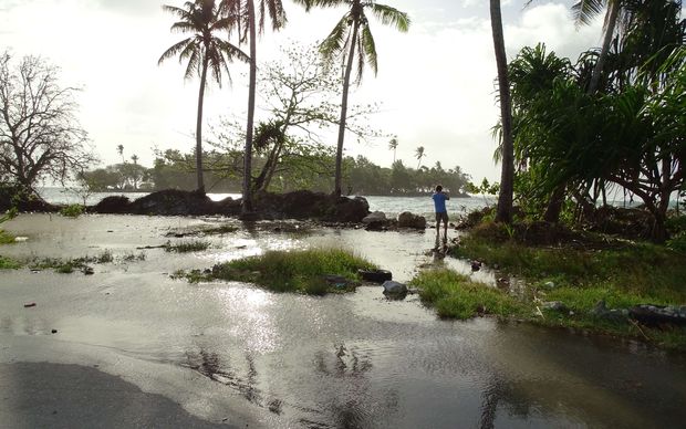
10 March, 2016. King tide causes flooding in Marshall Islands
Several hundred residents of Kili Island in the Marshall Islands were forced to move when their homes flooded from a king tide pushed by storm surges.
It is the second time in as many years that high tides have caused significant flooding on Kili, home to displaced Bikini Islanders.

High tide inundation on a runway, Kili Island, Marshall Islands, February 2015.High tide inundation on a runway, Kili Island, Marshall Islands, February 2015. Photo: Kili/Bikini/Ejit Local Government Marshall Islands
But the king tide-caused inundation in Majuro, the nation's capital, was mild compared to previous flooding in recent years.However roads in certain parts of the capital were flooded and debris was strewn across roads and in the backyards of local residents.
Some Majuro homes were flooded, but there were no immediate reports of major damage or any injuries.
The Bikini Mayor Anderson Jibas said in the evening, they had to move families from the northern part of Kili to the town area because their houses were flooded.
The mayor said he has given full alert to Public Works and Public Safety to look over the situation and to inform the community.
In Majuro, some homeowners whose houses and property were flooded with about six inches of seawater, called on the government to provide help in the form of seawalls and improving shoreline protection.
A king tide pushed by storm surges caused some inundation in Majuro Atoll, with water washing onto the roads and flooding homes in some areas of the capital atoll. Photo: Hilary Hosia.
An area in one section of Majuro known as "Jenrok" that frequently floods during annual king tides in February and March "saw debris strewn across the road, with several over-washes of up to four inches," said Karl Fellenius from the University of Hawaii Sea Grant program who is based in the Marshalls.
Dr Fellenius said Wednesday's flooding in Majuro "was the first ocean side inundation since typhoon Bavi a year ago in March."
Motorists had to navigate around sand, rocks and debris tossed up by waves onto the two-lane road that runs by Majuro's international airport runway.
US weather officials on Guam warned that flooding could continue this week because of the confluence of king tides and a storm that developed near Wake Island and is moving through the Marshalls. Source: radionz.co.nz
-
-
Queensland, Australia
1 March, 2016. Inskip Point landslide: beach gets sinking feeling

A picture from the Seven News chopper of the sinkhole that has formed at Inskip Point
Another collapsing sandy hole has formed at Inskip Point at the northern end of rainbow beach.
According to Queensland Parks and Wildlife the activity started at the surface of the sand about 8am and ended at 10.15am.
The service is describing it as an erosion event better termed as a "near-shore landslide" than a sinkhole.
'Thanks to my husband, I'm alive'
The erosion has not affected any campsites nor access to the barge to Fraser Island.The Queensland Parks and Wildlife Service has erected traffic barriers and warning signs around the sites.
A statement on the parks and wildlife website said it was likely to be "another occurrence of the natural phenomenon which occurred in September 2015 at Inskip".
In that incident 300 people had to be evacuated after campsites came under threat, and some cars that were swallowed up by sinking sand are still underwater.


Another major erosion event along Inskip Point beach, Queensland. Second one in six months. Source: twitter.com
"It is caused by the undermining of part of the shoreline by tidal flow, waves and currents," the statement said.
"When this occurs below the waterline, the shoreline loses support and a section slides seaward leaving a hole, the edges of which retrogress back towards the shore."
Members of the public were urged to observe the warnings in place around the area.

Sinkhole in 30 September, 2015. The sinkhole has been described as a "near shore landslide". Photo: Kieren Hudson/Higgins Storm Chaser. Source: brisbanetimes.com.au
Rangers were monitoring the hole that has formed. Source: brisbanetimes.com.a
© 2024 Created by 0nin2migqvl32.
Powered by
![]()
You need to be a member of Earth Changes and the Pole Shift to add comments!
Join Earth Changes and the Pole Shift