Please Place Evidence of the 7 of 10 Plate Movements Here
Kojima had created small snips of Konstantin's animation of the 7 of 10 Plate Movements.
Here is the full 7 of 10 Animation by Konstantin.
This blog is the place to document ongoing earth changes related to the 7 of 10 plate movements as described by the Zetas.
ZetaTalk: 7 of 10 Sequence
written October 16, 2010
The 7 of 10 scenarios describe plate movements, and for this to occur something has to release the deadlock, the current stalemate where the plates are locked against each other. Once the deadlock is broken and the plates start moving, sliding past each other, new points where the plates are locked against each other develop, but these are weaker locks than the one at present. The current lock, as we have so often stated, is the Indo-Australian Plate which is being driven under the Himalayans. This is no small lock, as the height of the Himalayans attests. Nevertheless, the activity in this region shows this likely to be the first of the 7 of 10 scenarios to manifest. Bangladesh is sinking and the Coral Sea is rising, showing the overall tipping of the Indo-Australian Plate. Now Pakistan is sinking and not draining its floods as it should, while Jakarta on the tongue of Indonesia is also sinking rapidly, showing that the tilt that will allow Indonesia to sink has already started.
Meanwhile, S America is showing signs of a roll to the west. Explosions on islands just to the north of the S American Plate occurred recently, on Bonaire and Trinidad-Tobago, and the Andes are regularly being pummeled. There is a relationship. As the Indo-Australia Plate lifts and slides, this allows the Pacific plates to shift west, which allows S America to shift west also. This is greatly increased by the folding of the Mariana Trench and the Philippine Plate. But it is the Indo-Australian Plate that gives way to incite change in these other plates, and this is what is manifesting now to those closely following the changes. Once the folding of the Pacific has occurred, Japan has been destabilized. We are not allowed to give a time frame for any of these plate movements, but would point out that it is not until the North Island of Japan experiences its strong quakes that a tsunami causing sloshing near Victoria occurs. There are clues that the New Madrid will be next.
Where the N American continent is under great stress, it has not slipped because it is held in place on both sides. The Pacific side holds due to subduction friction along the San Andreas, and the Atlantic side holds due to the Atlantic Rift's reluctance to rip open. What changes this dynamic? When S America rolls, almost in step with the folding Pacific, it tears the Atlantic Rift on the southern side. This allows Africa freedom to move and it rolls too, dropping the Mediterranean floor above Algeria. What is holding the N American continent together has thus eased, so that when the Japan adjustments are made, there is less holding the N American continent in place than before, and the New Madrid gives way. We are also not allowed to provide the time frame between the Japan quakes and New Madrid. Other than the relationship in time between the New Madrid and the European tsunami, no time frame can be given. The sequence of events is, thus:
- a tipping Indo-Australia Plate with Indonesia sinking,
- a folding Pacific allowing S America to roll,
- a tearing of the south Atlantic Rift allowing Africa to roll and the floor of the Mediterranean to drop,
- great quakes in Japan followed by the New Madrid adjustment,
- which is followed almost instantly by the tearing of the north Atlantic Rift with consequent European tsunami.
Source: http://www.zetatalk.com/index/zeta584.htm
Tipping Indo-Australia Plate with Indonesia sinking,
http://zetatalk.com/7of10/7of10-23.htm
http://zetatalk.com/7of10/7of10-24.htm
http://zetatalk.com/7of10/7of10-25.htm
http://zetatalk.com/7of10/7of10-26.htm
http://zetatalk.com/7of10/7of10-28.htm
http://zetatalk.com/7of10/7of10-30.htm
http://zetatalk.com/7of10/7of10-31.htm
http://zetatalk.com/7of10/7of10-32.htm
http://zetatalk.com/7of10/7of10-34.htm
http://zetatalk.com/7of10/7of10-37.htm
Folding Pacific
http://zetatalk.com/7of10/7of10-33.htm
http://zetatalk.com/7of10/7of10-38.htm
http://www.zetatalk.com/info/tinfx351.htm
http://zetatalk.com/7of10/7of10-47.htm
South American Roll
http://zetatalk.com/7of10/7of10-39.htm
http://zetatalk.com/7of10/7of10-40.htm
http://zetatalk.com/7of10/7of10-41.htm
http://zetatalk.com/7of10/7of10-42.htm
http://zetatalk.com/7of10/7of10-43.htm
http://zetatalk.com/7of10/7of10-44.htm
http://zetatalk.com/7of10/7of10-45.htm
http://zetatalk.com/7of10/7of10-47.htm
African Roll
http://www.zetatalk.com/7of10/7of10-46.htm
http://zetatalk.com/7of10/7of10-47.htm
http://zetatalk.com/7of10/7of10-48.htm
http://zetatalk.com/7of10/7of10-52.htm
Japan Quakes
http://www.zetatalk.com/7of10/7of10-53.htm
http://zetatalk.com/7of10/7of10-54.htm
New Madrid
http://www.zetatalk.com/7of10/7of10-59.htm
http://www.zetatalk.com/7of10/7of10-60.htm
http://zetatalk.com/7of10/7of10-61.htm
http://www.zetatalk.com/7of10/7of10-62.htm
http://zetatalk.com/7of10/7of10-63.htm
http://zetatalk.com/7of10/7of10-64.htm
http://zetatalk.com/7of10/7of10-65.htm
http://zetatalk.com/7of10/7of10-68.htm
European Tsunami
http://zetatalk.com/7of10/7of10-70.htm
http://zetatalk.com/7of10/7of10-71.htm
http://zetatalk.com/7of10/7of10-72.htm
http://zetatalk.com/7of10/7of10-73.htm
http://zetatalk.com/7of10/7of10-74.htm
Due to the slowing of the 7 of 10 plate movements by the Council of Worlds the impact of some of the events described above will be lessened.
The Zetas explain:
ZetaTalk: Pace Slowed
Written May 19, 2012
The effect of the thousands of humming boxes placed along fault lines and plate borders can be seen in several incidents that have occurred since the start of the 7 of 10 plate movements. The lack of tsunami during the 7 of 10 sinking of the Sunda Plate is one such example. We predicted at the start of the 7 of 10 scenarios in late 2010 that the Sunda Plate sinking would occur within 2-3 weeks, yet it dragged on through 2011. At the time we had predicted tsunami on the Sunda Plate, in general equivalent in height to the loss of elevation for a coastline. None of this occurred due to the slower pace.
The pace of mountain building in S America, where slowed, has still resulted in rumpling up and down the Andes, and stretch zone accidents likewise in lands to the east of the Andes. The shape of S America has clearly changed. Will the islands in the Caribbean be spared? At some point, as with the magnitude 7.9 quake in Acapulco on March 2, 2012 a significant adjustment will need to occur, and this will include depressing the Caribbean Plate so it tilts, sinking the islands and lands on that portion of the plate to the degree predicted. But the S American roll will likely continue to avoid the magnitude 8 quakes we originally predicted in deference to slow rumpling mountain building. The African roll was anticipated to be a silent roll in any case, so the slowed pace would not affect the outcome.
Will the slowed pace prevent the 7 of 10 scenarios for the Northern Hemisphere? Bowing of the N American continent has reached the point of pain, with breaking rock booming from coast to coast, but still there have been no significant quakes in the New Madrid area. Yet this is past due, and cannot be held back indefinitely. What has and will continue to occur for the Northern Hemisphere scenarios are silent quakes for Japan, which has already experienced drastic subduction under the north island of Hokkaido where mountain building is occurring as a rumple rather than a jolt. However, the anticipated New Madrid adjustment cannot be achieved without trauma. But this could potentially occur in steps and stages such that any European tsunami would be significantly lessened.
All rights reserved: ZetaTalk@ZetaTalk.com
Source: http://www.zetatalk.com/7of10/7of10109.htm
ZetaTalk , Written March 10, 2012
What happens when the pace of plate movement is slowed? The likelihood of tsunami is definitely reduced, as can be seen in the sinking on the Sunda Plate. The sinking occurred, and is almost complete, yet the possibility of tsunami we predicted for various regions on the Sunda Plate were avoided. The height and force of a tsunami is directly related to the degree of displacement in the sea floor, and if this happens in steps rather than all at once the displacement will be less for any given step.
This bodes well for the European tsunami. If the Council of Worlds is still imposing a slower pace on the 7 of 10 plate movements, this tsunami will definitely be lessened. The tear in the North Atlantic will be slight, each time. The amount of water pouring into this void will be less, each time. And the rebound toward the UK will likewise be less, each time. But our prediction is the worst case situation, and it also reflects what the Earth changes, unabated, would produce.
But what does a slower pace do to land masses where jolting quakes are expected? Does this reduce the overall magnitude of the quakes anticipated? Large magnitude quakes result when a catch point along plate borders is highly resistant, but snapping of rock finally results. Usually there is one place, the epicenter, where this catch point resides and a long distance along the plate border where smaller quakes have prepared the border for easy movement. A point of resistance within the body of a plate, such as the New Madrid, can likewise resist and suddenly give.
There is no way to lessen the resistance at these catch points, though the tension that accompanies such points can be reduced so that the quake itself is delayed. What this means for a slower 7 of 10 pace is that large magnitude quakes will be spread apart in time, and their relationship to our predictions thus able to be camouflaged by the establishment. Where sinking (such as the Caribbean Island of Trinidad) or spreading apart (such as to the west of the Mississippi River) are to occur, these land changes will eventually arrive. But like the sinking of the Sunda Plate, a slower pace unfortunately allows the cover-up time to maneuver and develop excuses.
All rights reserved: ZetaTalk@ZetaTalk.com
Views: 117176
Comment
-
Comment by Khan on July 27, 2015 at 9:06am
-
Banglades: Tidal surge, heavy rains trigger flooding in coastal areas
July 27, 2015
A road submerged by rainwater in Maijdee Court area of Noakhali yesterday. INDEPENDENT PHOTOTorrential rains, onrush of water from upstream and high tide have inundated vast areas in coastal districts, leaving tens of thousands of people marooned.
The normal life in Bhola district has been disrupted due to flooding of homesteads over the past one week.
Sources said the rain that started a week ago has been continuing till yesterday. As a result, the water level of the River Meghna has risen inundating the low laying areas, including the Char (shoal) lands located on both the sides of the river. Majher Char and Rajapur Char of Bhola sadar, Medua Madanpur and Hajipur union of Daulatkhan upazila, Char Johir Uddin of Tajumuddin upazila and Dhal Char, Char Patila and Chars of Monpuyra upazila go under water during tide every day.
On the other hand, erosion has taken a serious turn devouring new areas in the district.
Following the week long torrential rains standing crops on a vast tract of lands, especially the char areas of the district were inundated.
The low-laying areas in Bhola town have been gone under water due to the heavy showers.
Thousands of fishermen and low-income people, including day labourers, are spending idle time. The fishermen cannot sail into the turbulent sea for catching fish and day labourers are not called for work for continuous rain.
Sources in the agriculture department said it is the time for sowing Aman seeds and preparing lands for transplantation of seedlings, but it is being hampered seriously due to the water logging and rain.
Our correspondent from Nokahlai reports: The low-lying areas in Fulgazi and Parshurm upazilas in Feni town have gone under water and shoal areas in Subarnachar, Hatiya have been inundated by torrential rains and tidal surge, caused by a depression in the Bay of Bengal.
Mohari River in Uttar Dulatpur of Fulgazi upazila continued to flow 80 to 85 cm above the danger level on Saturday.
Hundreds of people have been marooned, fish enclosures and standing crops damaged by water during the last 24 hours.
Sources said rain water has inundated Shahid ullah kaser roads, Lalpur, Fetepur, Mohipal areas in Feni district. Local newsman of Feni Bokthier Islam Munna said water has entered his house on Friday night.
Nirbhai Officer of Fulgazi upazila Mahidur Rahman said flood control embankment of Mohari River has collapsed at two places in Shapur and uttar Daulatpur villages due to heavy down pour.
Nearly 4,000 families have shifted to safer places, the UNO said. The upazila administration has distributed dry food among the affected people, he said.
UNO Hatiya Abu Hasnat Md Mohin Uddin quoting chairmen of respective unions said the tidal waters entered vast areas through the breaches of the flood control embankment at Naler char point. As a result, shrimp in the enclosures, fish in the ponds have been washed away.
-
-
Sea wall along coastal road could lead to more floods in Mumbai.
July 27, 2015
Experts say it will stop channels of water entering the sea and cause flooding.
If there is one thing the Brihanmumbai Municipal Corporation (BMC) has consistently shown when it comes to providing civic amenities and infrastructure congruous with the environment, it is that it never learns to do so.
While Sunday marked the completion of 10 years since the 26/7 Mumbai floods, it has now come to light that two of the BMC’s most ambitious plans Development Plan (DP) and coastal road will not do anything to prevent flooding in the city.
While the DP makes no specific provisions to arrest flooding, a sea wall to be constructed for the coastal road may actually cause more flooding, since it will stop channels of water entering the sea.
Wall of problems
Well-known architect P K Das has criticised the DP as well as the coastal road in public forums. He said, “A sea wall has been envisaged along parts of the coastal road. But construction of such walls is banned in the US and Europe.Officials’ assumption that it will prevent storm surges is archaic. It will in fact lead to flooding, since the wall will prevent floodwater entering the sea. If a natural drainage channel underground is severed, it will result in a counter action and cause flooding in the city.”
Environmentalist Rishi Agarwal also said that it was possible that the sea wall might lead to what retaining walls along some of Mumbai’s rivers led to. “Retaining walls were built for Dahisar, Poisar, Mithi rivers, which actually caused rain water to head towards the land. So I am unsure of the impact of the sea wall on flooding.”
Road to troubles
Hussain Indorewala, assistant professor at Kamla Raheja Vidyanidhi Institute for Architecture, who has been studying the coastal road project, said, “The 2005 floods were mainly caused because of the intensity of rain, which was 125 mm/hour while our drainage systems are equipped to handle only 25 mm/hour.The recent June 19 rains had an intensity of only 38 mm/hour and, even then, there was flooding. This means 26/7 may happen again. Besides, the coastal road will destroy mangroves which act as a natural absorption channel for flood water, on a large scale.”
According to Indorewala, the coastal road will further reduce the width of the Juhu nullah and Malad creek. “Mangroves near the Malad creek will be destroyed for the road to be constructed there. This means all areas adjacent to the Malad creek (upstream) will be flooded during monsoons,” he said.
The coastal road’s environment impact assessment report states that mangroves should not be destroyed. Raghavanand Haridas, an architect from Santacruz, also criticised the coastal road for its tremendous costs to the public exchequer. “In the erstwhile development plans, a ring road was proposed between Bandra and Borivli.
Why can’t that concept be developed? Why do we need the coastal road at all?” Today (July 27) is the last date for submitting suggestions and objections for the coastal road. The civic body has received around 60 of them so far. The draft development plan released by the civic body in February, also makes no separate provisions to prevent flooding.
Only broad outline
“We have made provisions for additional pumping stations in the DP. Besides, the Development Control Regulations (DCR) stipulate certain things such as distance of a building from a nullah and plinth height. But no other provision was made.After all, the DP only gives a broad outline for the city. The specific departments should deliberate on this,” said V K Phatak, consultant to the BMC for the original draft DP. The DP is now being revised and suggestions/ objections are supposed to be incorporated.
-
-
Pakistan: Old problems, unresolved- Floods in Bhudni nullah leave locals stranded
July 27, 2015
People stranded and traffic suspended in Bhudni Pul area. PHOTOS: MUHAMMAD IQBAL/EXPRESS
“Residents in Usmania Colony on Warsak Road have placed sand-filled bags on the sides of the nullah to protect houses from flooding,” said a local government councillor, Manzoor Ali. Four days ago on Thursday, the same colony had flooded with waste when garbage and rainwater mixed and seeped into houses and shops. However, the problem repeated itself on Sunday when the nullah flooded.
Some residents also took shelter on roofs. Standing water caused traffic to suspend on Peshawar-Charsadda Road, disconnecting parts of the district.
According to DC Riaz Mehsud, the district government diverted traffic from the route, and asked transporters to use the Peshawar-Islamabad Motorway instead to go to Charsadda. Ambulances were also deployed in vulnerable areas.
Rescue efforts and encroachment
Rescue 1122 teams have so far helped 40 people evacuate houses. The teams faced difficulties in evacuating the residents as encroachments blocked their access. Some people were also reluctant to leave their houses despite the flooding.
When contacted, Rescue 1122 Spokesperson Bilal Faizi said the teams included divers who were on the run—visiting flooded houses in rescue boats—to ensure timely evacuation and avoid loss of life.
Faizi added mostly children and older adults were the ones stranded
Minister for Information Mushtaq Ghani also visited Bhudni Pul and monitored the situation. He directed the district government, police, Provincial Disaster Management Authority (PDMA) and Rescue 1122 to forcibly evacuate people even if they refuse so that loss of life can be avoided.
-
-
India: Over 4,500 people died in floods in last 4 years
23 Jul, 2015
NEW DELHI: Over 4,500 people lost their lives in floods in the last four years and nearly 26,500 villages were affected, which were washed away either partially or fully, the government today said.
Replying to a question in Lok Sabha, Minister of State for Water Resources Sanwar Lal Jat said that according to Home Affairs Ministry, 26,449 villages were affected by floods during the last three years and current year till July 19.
This includes the villages washed away partially or fully, he added.
As per statewise data on the number of lives lost due to the floods in the last three years, a total of 4,553 people were killed, with Uttarakhand topping the list with 800.
The total damages to crops, public utilities and houses during the last three years is estimated at Rs. 40,60,758 crores, the data revealed.
-
Comment by Stanislav on July 8, 2015 at 11:13am
-
Jamaica
3 July, 2015. Sea Floods Rocky Point Community

Residents in Rocky Point, Clarendon, are now on edge as water from the sea has flooded the community.
This morning residents woke up to flooded streets and yards as high tides caused huge volumes of water to flood the entire Shearer Heights area. One resident, who gave her name as Pedro, said the water started flooding houses sometime around 1 a.m. when it was extremely windy.
"A lot of people house flood out and nobody cannot leave them premises and go anywhere, you can’t get nowhere to walk. People furniture and appliances get damaged by the sea water. We are scared man, we can’t come out," she told The Gleaner.
She said the drains are flooded and the situation is getting worse each day.
The affected residents said they have been experiencing the effects of this high tide for the last six weeks and fisher folk have been unable to venture out to sea.
However, one fisherman is feared lost at sea after he braved the weather and went out last night.
Another boat left in search of him at daybreak. Fishing equipment including huts and boats have also been damaged as a result of the strong winds.
Councillor for the Rocky Point Division, Winston Maragh, who visited the community this morning, said the main roads are inaccessible as they are flooded. He added that a senior citizen’s home and a basic school are also severely affected by the flood waters.
"Many persons have to park their vehicles in a yard on the hill and walk home, so it’s a serious problem," he said.
Maragh said based on the assessments carried out, 25 per cent of Rocky Point is currently flooded.
He has suggested a temporary solution of covering the area with river shingle and marl to give residents access to their homes.
However, he said the National Works Agency says a sea wall may be needed to solve the problem on a more long-term basis. Source: jamaica-gleaner.com
-
-
Philippines:

The barangay hall of Tinumigues in Lambayong town, Sultan Kudarat on Wednesdaay, June 24. Flashfloods brought about by continous heavy rains since Tuesday night temporarily displaced some 25,000 residents in four towns and one city in Sultan Kudarat province on Wednesday. MindaNews photo by Ferdinandh B. Cabrera
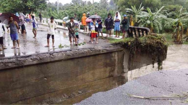
RESIDENTS of the village of Concepcion in Koronadal City find themselves cut off from the rest of the city after strong river currents swept away a portion of the village bridge. @AL SALUDO/CONTRIBUTOR

Floods in Cotabato. Source: interaksyon.com
25 June, 2015. No heavy rain, but bridge collapses, 3 dead in South Cotabato floods
Three people were killed, a major bridge was damaged and several areas of South Cotabato were submerged in flood waters following hours of light to moderate rain that started on Tuesday.
Tupi, South Cotabato Mayor Reynaldo Tamayo said separate landslides took place in Barangay Bunao and Lunen and killed three people.
Tamayo did not identify those killed but added that the landslides were triggered by the rain.
“A little rain here causes flood already,” said Sid Samaniego, municipal media relations officer.
Flooding was also reported on Tuesday in Legazpi City, Albay province. Edwin Fernandez, Inquirer Mindanao with Maricar Cinco and Michael Jaucian, Inquirer Southern Luzon. Source: newsinfo.inquirer.net
24 June, 2015. 3 die, 800 displaced in SouthCot, S. Kudarat floods
Three people have died while around 800 residents were displaced in parts of South Cotabato and Sultan Kudarat provinces as flashfloods and landslides hit the area early Wednesday.
Reports from local Disaster Risk Reduction and Management (DRRM) offices said the floods and landslides occurred following the almost non-stop heavy to moderate rains that started on Tuesday evening.
In South Cotabato, severe flooding were reported in the municipalities of Banga, Norala, Tantangan, Tupi and Koronadal City due to the swelling of several rivers and tributaries.
Landslides were also reported in Barangays Bunao and Lunen in Tupi after a portion of a mountain collapsed at the height of heavy rains early Wednesday.
In Banga town, the MDRRMO reported that some 280 families composed of 600 individuals have evacuated due to the flashfloods that affected eight barangays.
An initial 117 hectares of palay farmlands were damaged as a result of the floods in Barangays Yangco, Malaya, Cabuling, Reyes Punong Grande, Rizal, Rang-ay and Cinco.
Arman Palomar, Yangco barangay chairman, said 280 families were forced to leave their homes as early as 2 a.m. after huge volumes of floodwaters from nearby Banga River swept their area.
He said some 75 houses sustained various damages due to the floods that reached about four feet. Source: mindanews.com
India:
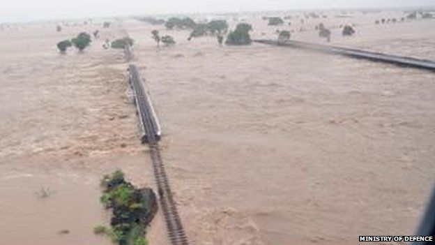
The Saurashtra region is the worst-hit by floods. Source: bbc.com

MI-17 V5 helicopters of Indian Air Force carrying out rescue and relief operation in Amreli district. Source: ibtimes.co.in
25 June, 2015. Floods kill 41 in western India
Flash flooding triggered by torrential rains has killed 41 people in India’s western Gujarat state, as the annual monsoon season hits the country, a disaster management official said Thursday.
Authorities have evacuated more than 10,000 residents mainly from coastal areas of Gujarat following heavy rains in the last 24 hours, the state government said in a statement.
The coastal district of Amreli was the worst affected, with 36 people killed in flood-related incidents, a duty officer in the state’s disaster control room said.
“There have been 41 deaths across the state with 36 in Amreli, three in Bhavnagar and two in Rajkot districts,” the official told AFP.
Thirteen of the deaths in Amreli occurred when two houses collapsed in the flooding, local police deputy superintendent Pinakin Parmar told AFP.
India normally sees flooding during the monsoon but the intensity of this year’s rains in Gujarat has surprised many.
The air force has been deployed to help with evacuations, including that of 44 passengers of a bus stuck on a flooded highway near Amreli town, the government’s statement said.
In photos released by the defence ministry, families were shown huddling on rooftops of flooded homes awaiting rescue, along with washed out train tracks and roads.
India’s weather bureau has forecast more heavy rain in Gujarat for the next two days.
As the monsoon sweeps across the country, flood warnings have also been issued in northern Jammu and Kashmir state — hit by floods last year that claimed about 300 lives.
Waters were receding in northeastern Assam following floods there last week. But more than 20,000 people were still waiting to return home after moving to higher ground after the rain hit, the Press Trust of India said.
Nearly 900 hectares (2,223 acres) of farm land was also still under water in that state, the news agency added.
The monsoon is vital for South Asia especially for crop production. India receives nearly 80 percent of its annual rainfall between June to September period. Source: tribune.com
Vietnam:

A man transporting rice cakes for sale on his bicycle, looks at his produce while standing on a flooded street in Vietnam's central ancient town of Hoi An on Nov 18, 2013. Photo: Reuters
24 June, 2015. Flash Floods Kill 7, Leave 4 Missing in Northern Vietnam
A disaster official says flash floods triggered by a tropical storm have killed seven people and left four others missing in a northern Vietnamese province.
Tran Viet Phuong in Son La province said Thursday that authorities are still searching for the four missing, including a four-year-old boy whose house was washed away.
Flash floods washed away more than 20 houses in the province, he said.
Tropical Storm Kujira which slammed northern coast on Wednesday has now dissipated, according to the national weather forecasters.
The storm has dumped up to 20 centimeters (nearly 8 inches) of rain on many parts of northern region over the past two days.
Vietnam is prone to flood s and storms, which kill hundreds of people each year. Source: todayonline.com
-
Comment by casey a on May 25, 2015 at 1:05am
-
hmm. at the bottom it say "Water data courtesy of US Bureau of Reclamation"
The bureau of reclamation website shows that the lake mead's water level lost 7 ft @ 11pm on the 23 May. Before it & After it the water levels @ Mead are at 1077 ft., though.
When the drop in Mead's elevation levels happen, there is a drop in the water release rate from Hoover dam, also. But earlier in the day, there were even bigger drops in the rate at which water was released out of Hoover; yet the water levels at Mead remained @ 1077 ft.
The funny thing is in the next hour on the 24th, water levels have gone back to the 1077ft level. Either numbers are fudged or this was some sensor malfunction.
(trying to think of how else this could have happened. Wasn't sure which way colorado river flows. So, putting this here)
-
Comment by Kris H on May 25, 2015 at 12:09am
-
@casey, that is interesting, because I was curious if the water level had *risen*. Zetas has also said that the Hoover Dam intakes would get clogged and force floodwaters back into Las Vegas. But a drop instead? Maybe the lake deepened? So level dropped?
-
-
5.4 magnitude Earthquake took place in Nevada on May 22. Next day there is a drop of 7 ft in Lake Mead's water levels.


this was zetatalk re: the methane hot spot east on the Four Corners are. Perhaps related.
The noted methane “hot spot” lies on the Continental Divide, and is caused by cracking rock under the surface. The steady press of mountain building is one factor, but the cause is two-fold, as that spot also lies along the center of the bow in the N American continent. Draw a line from the central California hot spot through to the methane hot spot in the four-corners region. The line runs dead East, along the most intense bowing stress. Rock is cracking open to release methane from vegetation trapped when the Continental Divide pushed over land in the past.
Did the bowing stress on N American begin in 2003? It began when Planet X entered the inner solar system in 2003 and began to put the globe into its daily Figure 8 wobble. NASA knows this. They are not trying to determine why the methane hot spot exists, but to monitor its progress. They are looking for an increase in these signs. The US government is already alarmed at the many signs that the New Madrid adjustment, long predicted by ourselves, is about to begin. Excuses given, such as coal seams or man-made emissions out in the desert, are absurd.
-
-
Peru declares state of emergency in a district that is being swallowed by the earth
May 17, 2015Peru authorities have declared a state of emergency in 19 locations Piscobamba district in the province of Mariscal Luzuriaga (department of Ancash, west). The decision is due to a large ground cracks gradually sink.
© 2024 Created by 0nin2migqvl32.
Powered by
![]()
You need to be a member of Earth Changes and the Pole Shift to add comments!
Join Earth Changes and the Pole Shift