Landslides


"The causes of landslides are not a mystery to mankind. Layers of rock and soil such that rain running along a clay or rock layer can create a slippery surface for the weight of the layers above it is a common cause. A rock jumble from previous mountain building, broken or fractured rock easily dislodged. We have stated that the earthquakes man experiences between the periodic passages of Planet X can be considered aftershocks from the last passage, and this is true of landslides also. Mountain building rumples the landscape, so the land is not flat but has steep ravines and hill sides. Older mountain ranges are recognized for their rounded or smoothed appearance, because of frequent landslides distributing the rubble.
"As we approach another passage, another Pole Shift, the pace of landslides has picked up. Why would this be? Plates under pressure will put pressure on regions that contain rumpled hillsides and deep ravines, as these give more readily than strictly flat land, thus act as a weak link. In addition, due to the wobble, the weather has gotten more extreme, with drought and deluge increasing in extremes. Dry ground, suddenly flooded with rainwater needing to seek its level as runoff, will create internal water slides between the rock and soil layers that constitute the rumpled hillsides. Is there an early warning system that mankind could use? The trembles that soil about to slide emits could be detected, yes. These are not earthquakes, and have their own frequency. "
Views: 122079
Comment
-
Comment by Andrey Eroshin on September 18, 2014 at 4:26pm
-
12.09.14. Massive ground movement in El Salitre, Boyacá, Colombia
http://prensalibrecasanare.com/yopal/12897-en-evaluaciun-posible-am...
-
Comment by SongStar101 on September 13, 2014 at 8:55pm
-
North American bow stress, rock fracturing in Sierra Nevada Northern CA region compressing and 'peels' away...
http://geotripper.blogspot.com/2014/09/ongoing-exfoliation-event-at...
A big chunk of the Sierra Nevada caught fracturing on video
There is an ongoing geological drama going on the Sierra Nevada that may be unique (to the extent of my knowledge, which is admittedly limited in this area). Exfoliation, a process long recognized as the shaper of granitic domes and monoliths, is presently busting up the surface of a small dome at Twain Harte Lake a few miles east of the Mother Lode town of Sonora. The process has been captured on video, and is presently being monitored, due to the effects it is having on a reservoir abutment.
The event burst into the news in August when a possible dam failure warning was issued following a loud popping sound and the leakage of water from the edge of the reservoir. Once the site was investigated, a decision was reached to drain the lake until the full extent of the damage was clear. There have been at least three 'events', the last on August 3.
An employee of the lake association was very kind and allowed me to have a look at the dome and the new exfoliation shells. It was fascinating. The first thing to catch the eye was the lifeguard tower. It's tilted at an odd angle because the rock it is sitting on has been pushed upward into what is called an "A-tent" joint. My erudite and learned comment was "wow"!
Exfoliation is the breaking and fracturing of hard rocks like granite in slabs parallel to the surface of the rock. It removes corners and edges, resulting in the familiar domes found in regions like the Sierra Nevada where lots of granitic rock is exposed. It has traditionally been described as the result of 'unloading', whereby erosion strips off the overlying rock, releasing pressure and causing the rock to expand outwards, and fracturing in the process. There are some alternate explanations involving a certain amount of compression, which makes sense looking at the 'A tent' in the picture above.
There were freshly loosened slabs all over the surface of the rock, with lots of chipped edges. From the videos it is clear that the chips often snapped loose before the major slab event, like foreshocks to an earthquake (and given that earthquakes are also an example of stress release, the analogy is appropriate).I admit I never gave it any thought, but it seems clear that the fractures are occurring in a swarm, as the stress regime changes with each break, placing new pressures in different sectors. Like a series of aftershocks following an earthquake, the rocks will continue to shatter for a period of time until a new stable regime or equilibrium is reached. I don't know any details of how or if this process has been witnessed in the past, so I couldn't even speculate on how long these rock 'pops' will continue. Maybe they are already done, but I wouldn't count on it.
------------------------------------------------------
Another Article:
http://arstechnica.com/science/2014/09/a-big-chunk-of-the-sierra-ne...
-
Comment by Derrick Johnson on September 12, 2014 at 7:41am
-
J&K floods: Lakhs still stranded; landslides wreak havoc in Jammu, leave an entire village buried
Jammu/Srinagar: More than 1,10,000 people have been rescued from different parts of the flood-hit Jammu and Kashmir, but the death toll has crossed 200. Lakhs still remain stranded with many of them refusing to leave their homes. Rescuers want all people evacuated as there are concerns about the potential spread of water-borne diseases.
Over 20,000 Army personnel have been carrying out relief operations. 800 tonnes of relief material has been air dropped. The rain has now stopped and the water is receding in some areas. Where it has not receded, the Army is pumping water out to reach those trapped.
Restoring communication and connectivity is a priority. While communication lines have been restored to some extent, the Border Roads Organisation is working on restoring road links.
Meanwhile, the big fear in Jammu after the floods is that of landslides. More than 40 people lost their lives in a landslide in Sadal, a village near Udhampur. The village has been completely submerged by a landslide and has been buried under the debris. Rescue operations continue with the Army, National Disaster Response Force (NDRF) and State Disaster Response Force (SDRF) personnel deployed in the area.
The Sadal village was home to 53 families. The entire village slid down in a matter of minutes, burying all houses under tonnes of rock and mud. The villagers had no time to run to safety.
The Army rushed in 200 of its soliders to assist with rescue operations being carried out by the civil administration. The Army has been providing food to the villagers and arranging temporary shelter for them even as efforts are on to extract the bodies from the rubble. The site of the landslide is 4 km away from the nearest road, making it impossible to move heavy machinery to assist in the rescue operations.
For the families of the villagers who survived the landslide, it is a harrowing wait. Officers and men of the Udhampur Garrison say they will not vacate the area till the very last body has been pulled out. The Army stepped in after the civil administration said that a rescue operation of this scale was beyond their means. So much so the civil administration is now conspicuous in its absence and the rescue and relief operations are now being carried out single-handedly by the Army.

Source: http://ibnlive.in.com/news/jk-floods-lakhs-still-stranded-landslide...
-
-
07.09.14. Lanslide in Annaba, Algeria
http://www.autobip.com/ar/%D8%A7%D9%86%D9%87%D9%8A%D8%A7%D8%B1-%D8%...
http://translate.google.com/translate?hl=en&sl=auto&tl=en&a...
-
-
08.09.14. River bank 200 meters long collapsed in Mueang, Uttaradit, Thailand
http://www.utdclub.com/forum/forum.php?mod=viewthread&tid=30886
http://translate.google.com/translate?hl=en&sl=auto&tl=en&a...
http://www.thairath.co.th/content/449144
http://translate.google.com/translate?hl=en&sl=auto&tl=en&a...
-
-
07.09.14. Deep crack opened in San Cristóbal Honduras, Mexico
http://www.noticiasnet.mx/portal/oaxaca/general/grupos-vulnerables/...
http://translate.google.com/translate?hl=en&sl=auto&tl=en&a...
-
-
Jammu and Kashmir village snapped by landslide; 7 dead 31 missing
Tuesday, 9 September 2014 - 3:10pm IST | Place: Udhampur (J&K) | Agency: ANISadal Village, about 55 kilometers from Udhampur, has been completely submerged by a landslide. Road connectivity to it has been snapped from Kainthgali onwards.
Till now, seven dead bodies have been recovered and about 31 people are still missing in the area.
Rescue operations continue, with local police, residents giving a hand to National Disaster Response Force (NDRF) and State Disaster Response Force (SDRF) personnel deployed in the area. Air force choppers have also been deployed and people from adjoining areas have also come forward to help in rescue efforts.
Common masses of nearby villages are deeply gripped by fears of further landslides. A local resident of the area said, "It is a bigger tragedy than we could have ever imagined as many families are under the debris. We are waiting outside helplessly praying to God".
Local inhabitants have alleged that if this rescue operation had started earlier and in time, then they could have saved a few lives.
They also alleged that no temporary shelter, food or any other relief material has been provided to them by the district administration. They are demanding an early relief for landslide victims.
Additional Superintendent of Police (ASP) of Udhampur, Khalil Ahmed Poswal said, "Around 22 to 23 houses have till now buried in the debris. However, about 13 people have been safely escaped from the landslide and seven dead bodies have also been recovered."
"We have found some human organs in the landslides. 31 peoples are missing but efforts are on to search them. We are facing problem because the houses have been dislocated at about 400 meters from their original location," he added.
"Due to some connectivity problems the heavy machinery is not able to reach the spot. But manual and other equipment are used here to trace the missing persons," said Poswal.
Sadal is situated in the hill top area of Panjar in the Panchri area of Udhampur District in Jammu and Kashmir. It is about 70 km far and is one of the remotest and far flung area submerged under the landslide that occurred due to heavy rainfall.
Source: http://www.dnaindia.com/india/report-jammu-and-kashmir-village-snap...
Google Maps
-
-
Photos of night landslide in the village of Yingping in Guizhou province
http://www.weather.com.cn/guangxi/gxgqtp/2183958.shtmlhttp://translate.google.com/translate?hl=en&sl=auto&tl=en&a...
http://www.ddcpc.cn/2014/bd_0828/744.htmlhttp://translate.google.com/translate?hl=en&sl=auto&tl=en&a...
-
Comment by Mark on September 5, 2014 at 1:05pm
-
Landslide Closes Popular Forest Service Road on Haida Gwaii
Officials unsure what triggered the slide
http://www.cftktv.com/News/Story.aspx?ID=2164634
A landslide on Sunday evening has closed a popular forest service road on Haida Gwaii, which links Highway 16 with the west coast of Graham Island.
Ministry of Forests spokesperson Larry Duke says the slide happened sometime between 7 and 7:30 on Sunday night, on the Rennell Sound Road, at about the 11-kilometre mark.
There were no injuries reported, but the slide poured a large amount of mud and rocks onto the road.
At this point, he's not sure what triggered it.
"We had a bit of rain in the area, but what's interesting is it's not the typical levels of rain that would typically trigger landslide events, but talking with folks in and around the area that they report some pretty heavy rainfall. We've got a good sense that it was a combination of the rain with the steep steep slopes in the area plus the area had quite a bit of old blowdown that might have contributed to things," explained Duke.
He says there were about 60 people at the various recreation sites along Rennell Sound at the time of the slide.
-
Comment by Starr DiGiacomo on September 5, 2014 at 6:08am
-
http://www.radionz.co.nz/news/regional/253860/another-north-otago-c...
Another North Otago coast collapse
Another piece of the North Otago coastline has collapsed, further threatening a main waterfront route.
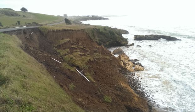
The collapsed section of Beach Road near Kakanui, North Otago.
Photo: RNZ / Ian Telfer
The Waitaki district council said a new section of the limestone shelf under Beach Road, between the towns of Kakanui and Oamaru, has broken away this week and is back to only one metre from the road.
In May an 80 metre long slip cut into the cliff edge below Beach Road and the road was subsequently reduced to one lane.
The council was investigating buying farmland to shift the road at least 20 metres inland.
Council roading manager Michael Voss said the slip was a safety concern and a fence was being put up on the road's shoulder to alert the public.
A geotechnical engineer was assessing the cliff face's stability.
© 2024 Created by 0nin2migqvl32.
Powered by
![]()
You need to be a member of Earth Changes and the Pole Shift to add comments!
Join Earth Changes and the Pole Shift