Dams at Risk: 65-Foot Crack in Washington State Dam
A large crack has been found in the Wanapum Dam on the Columbia River which supports the utility power supply to a major cluster of data centers in central Washington state.
65-Foot Crack Found in Washington State Dam (Feb 25)
The 2-inch-wide crack was found Thursday after divers were sent into the Columbia River because engineers detected a misalignment in a spillway on Wanapum Dam near the central Washington town of Vantage, said Tom Stredwick, a spokesman for the Grant County Public Utility District.
The Wanapum Dam generates more than 1,000 megawatts of electricity for the Grant County PUD, the utility that provides electricity to major data centers operated by Microsoft, Yahoo, Dell, Sabey Data Centers and Vantage Data Centers.
On February 25, dam officials noticed an irregular bowing of the dam near a section of a spillgate pier along the mile-long structure. Divers examined the area Thursday and discovered a two-inch wide crack running horizontally, located about 75 feet below the water’s surface. It runs the entire width of the 65-foot-wide pier.
The risk of a failure of the dam is high enough that the county has initiated an emergency plan. To relieve pressure on the dam, the water level is being lowered by 20 feet.
-------------------------------------------------------------------------------------------------------------------------------------------------
Owen Falls Dam in Uganda Falling Apart (Feb 28)The Owen Falls dam in Jinja could cave in, if the cracks and damage to the dam are not repaired, an official of Eskom, the hydro power generation company, has said.
Huge cracks continue to develop in the walls and supporting pillars of the dam. Water continuously sips through the gaping holes, expanding the cracks and making the dam weaker by the day.
-------------------------------------------------------------------------------------------------------------------------------------------------
Lake Manatee Dam at Risk of Collapse (Feb 14)
The Lake Manatee Dam in Bradeton, Florida is in a "severely distressed state" because of erosion, engineering consultants have found, forcing county officials to take corrective actions.
Heavy rains over four or five days could compromise the Lake Manatee Dam, Manatee County government warned in a news release February 14.
As a precaution, workers have begun to lower the water level of the lake.
Engineers and officials are concerned that the dam's clay core may have been compromised.
-------------------------------------------------------------------------------------------------------------------------------------------------
Water Gushes over Crumbling Dam in Zimbabwe (Feb 9)
A dam on the Tokwe river in the Masvingo area of Zimbabwe is close to bursting as water from heavy rains finding its way through gaps in the uncompleted dam wall.
Construction of the Tokwe Mukorsi dam began in 1998 but stalled in 2008. The dam was due to be completed at the end of last year but the deadline has passed with construction still not finished. Pictures from the area show water gushing through breaks in the wall and a huge build up of water in the reservoir behind it. Villagers have been evacuated as quickly as possible, with around 4,000 people believed to be at risk should the dam burst.
According to the Daily News, the Zimbabwe Air Force is helping people evacuate. The Minister for Masvingo province is quoted as saying that the government is on high alert and "A helicopter from the AFZ has been airlifting some families who were marooned by the floods but we are not yet sure how many people are still marooned."
-------------------------------------------------------------------------------------------------------------------------------------------------
"All dams will break either during the pole shift or in the months leading up to the hour of the shift. Look at the structure of the dam! It assumes that rock holding both sides of the dam will remain in place and not move. Of course these sides will move. This is a subduction zone! There is mountain building and even where the mountains are not being pushed upward, they are moving from side to side. Some parts are more fluid than others, which are more resistant during any earthquake thrust, so there IS inevitably movement to the side. They will pull apart, slide forward or backwards, but in any case the water will find its way around the dam."
Views: 29547
Comment
-
Comment by Starr DiGiacomo on May 30, 2018 at 5:39pm
-
http://www.newsweek.com/lake-tahoma-dam-latest-evacuations-north-ca...
Lake Tahoma Dam: Latest on Evacuations in North Carolina Amid Danger of Failure
May 30 2018
Emergency authorities in McDowell county, North Carolina have issued evacuation orders to thousands of residents as heavy flash flooding and landslides put the Lake Tahoma Dam at risk of failure.
The National Weather Service’s Greenville - Spartanburg station in South Carolina sent out a post saying that a landslide “has compromised the integrity of Lake Tahoma Dam” and called on those affected by mandatory evacuations to follow the orders. Spilling around the sides of the dam had already been reported.
“MANDATORY EVACUATIONS underway from the Dam at Lake Shore Dr to Lake Tahoma Rd (NC 80) to the confluence of the Catawba River near Resistoflex Rd and Riverside Park,” the service tweeted, “ACT NOW TO PRESERVE YOUR LIFE!”
McDowell County’s emergency management service wrote in a Facebook post that western and central parts of the county were seeing flooding and landslides. In an emergency message, the service said that the evacuation of areas below the lake were due to “recommendation from dam engineers.”
Engineers will be able to evaluate the dam during daylight hours, the message read. People in the affected communities can head to shelters at the YMCA of Marion, Glenwood Baptist Church and Old Fort Baptist Church.
-
-
https://www.youtube.com/watch?v=lzR0cKUn-Zk
Government issues evacuation alert following the overflow at Masinga dam
-
-
https://www.theguardian.com/world/2018/may/16/colombia-tens-of-thou...
Colombia: tens of thousands ordered to evacuate after floods at dam
600 people already left homeless after heavy floods at hydroelectric dam project, with another wave of flooding feared
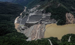 The dam of the Hidroituango Hydroelctric Project, on the Cauca river, near Ituango municipality in Colombia on 12 May 2018. Photograph: Joaquin Sarmiento/AFP/Getty ImagesTens of thousands of people have been ordered to evacuate their homes in western Colombia after heavy floods at Colombia’s largest hydroelectric dam project, which had already displaced hundreds over the weekend.The Hidroituango dam on the river Cauca was in the final stages of construction when a blocked tunnel was cleared on Saturday night, causing flooding downstream that swept through a riverside hamlet. Six hundred people were left homeless and two bridges, two schools and a health centre were destroyed.On Wednesday, authorities issued evacuation orders for eight municipalities downstream from the dam amid fears of another wave of flooding as heavy rains continue to batter the megaproject.The total number of inhabitants in the eight municipalities is believed to number up to 120,000. So far no deaths or missing people have been reported.
Videos circulating on local media show the harrowing scenes at the dam. One clip shows workers running from massive waves, while another shows flood water engulfing digging machinery.
“In the next few minutes, the flow of water from the Cauca river will be increased, downstream of the dam,” a text alert sent by EPM, the company building the dam, shortly after midday read. “People should go immediately to the meeting points.”
The latest emergency was triggered after an engine room at the dam reportedly collapsed. Colombia’s army, police and disaster management agency were dispatched to the site in the north-western Antioquia province. Red Cross personnel have been on the scene since Saturday.
“We are talking about people being displaced every hour,” Isabel Cristina Zuleta, an activist with Ríos Vivos, a local environmental organisation long opposed to the megaproject, told the Guardian from a Sabanalarga, a town upstream affected by floods over the weekend. “The high water pressure is causing landslides and floods upstream right now.”
“Communities are losing their way of life,” she said. “There’s no humanitarian assistance here, it’s total abandonment – there’s no shelters, no food, no anything.”
With water levels rising by the hour, Antioquia’s state governor, Luis Pérez Gutiérrez, who had previously brushed off the crisis as a “minor impasse” declared the situation a “public calamity” on Monday. Juan Manuel Santos called an emergency meeting with cabinet members and environmental agencies on Tuesday night.
The precise cause of the disaster is contentious. EPM’s manager, Jorge Londoño, told local media that “unpredictable geological conditions” had caused the tunnel to fill and then collapse over the weekend, while activists argue that it was caused by an accumulation of plant material left uncollected by the company. Swaths of surrounding dry tropical rainforest was deforested to clear space for the dam’s reservoir.
The crisis had been brewing since late April, when a blockage in the diversion tunnel was breached, causing water levels to rise both up- and downstream.
Several landslides, caused in part by heavy rain, led to further blockages throughout early May.
Authorities told residents that the emergency was under control, but many are now homeless.
“My house is still there but everything in it is destroyed,” said Richard Pasta, who lived 35 miles upstream from the dam and fled when water started to reach his doorstep last week. He is now in Sabanalarga, a nearby village further from the river, awaiting aid. “This was foreseeable, this is what happens when you mess with nature.”
Many locals in the region have long opposed the project, which has disrupted agriculture and fishing since the licence was granted to EPM in 2009.
Armed groups also operate in the region owing to its wealth of illegal gold mines and cocaine trafficking routes
Three community leaders from the area were shot dead by unknown assailants this month in two separate incidents. Two of the victims were members of the Ríos Vivos movement and had been campaigning for compensation for communities affected by the project.
Despite the controversies, the Hidroituango dam is being touted as a landmark project by the government and EPM – which is owned by the city of Medellín, 106 miles away. At full capacity the dam should be capable of generating an annual average of 13,930 gigawatt hours through its eight massive turbines. The project has received funding from IDB Invest, the private-sector branch of the Inter-American Development Bank.
The project is due to be fully operational by the end of the year. Around 11,000 people are working round the clock to drain the water and finish construction, the company said
-
-
https://www.nation.co.ke/video/news/4146788-4557330-etap8tz/index.html
At least 20 people dead after walls of Patel Dam in Solai, Nakuru, collapse
1 day ago
Brygettes Ngana reports from nakuru where at least 20 people have been confirmed dead and hundreds of families displaced after the walls of Patel Dam in Solai broke down. Rongai police boss Japheth Kioko said 20 bodies had been recovered, with search and rescue operation ongoing.
-
-
https://www.dailystar.co.uk/news/world-news/701717/kenya-dam-burst-...
Burst dam leaves HUGE trail of destruction with at least 47 dead
AT least 47 people have been killed after a dam burst overnight in Kenya.
Published 10th May 2018
The structure gave way following weeks of heavy rain that lashed Kenya.
Nakuru county official, Lee Kinyajui, said the burst happened in Solai on Wednesday night.
He added: “The water has caused huge destruction in both life and property.
“The extent of the damage has yet to be ascertained.”
Private television station KTN News initially said that 20 bodies have been recovered from the scene.
But the latest toll rose to 47 and could increase further as more bodies are pulled from the mud, the local police chief said.
Japheth Kioko, the police chief for Rongai division, said: “So far it is 47 dead. We are still on the ground.”
Kenya, like other countries in East Africa, has experienced heavy rain over the past two months.
The government said on Wednesday that the rain had killed 132 people and displaced 222,456 people in 32 counties since March.
Kenya Red Cross said on Twitter it had rescued 39 people so far.
Rescue workers have been seen searching the wreckage for any survivors in the churned up mud.
Ambulances also arrived to ferry people to hospital.
and another:
Dam collapses, causes fishkill
Friday , May 11, 2018
http://www.sunstar.com.ph/article/1742497/Bacolod/Local-News/Dam-co...
A DAM of the sugar milling firm Central Azucarera de la Carlota Inc. (Caci) in Barangay Nagasi, La Carlota City, has collapsed and reportedly spilled over wastewater, causing fishkill among rivers of neighboring Pontevedra town.
Engineer Desiderio Figueroa, head of the Provincial Environment Management Unit of Negros Occidental (Pemuno), under the Department of Environment and Natural Resources-Environment Management Bureau (DENR-EMB) in Western Visayas, said his office received reports about the incident Tuesday afternoon, May 8.
Figueroa said upon conducting an inspection Wednesday, May 9, Pemuno saw some possible manifestations of pollution including discoloration of water and existence of dead fish in the river.
However, Pemuno cannot yet conclude or ascertain the cause pending the result of the water analysis conducted by an accredited laboratory in Bacolod City.
"We conducted the water sampling from downstream to upstream areas the following day after we received the report. The result is expected to come out within the next seven to 10 days," he added.
Collapse
Caci, in a statement Wednesday, said it is closely monitoring the water levels of the impounding dams at Barangay Najalin in La Carlota City.
The sugar mill, a subsidiary of Roxas Holdings Inc. (RHI), said the management is looking into the incident that apparently caused the break of the southern wall of its one dam.
Ramonito Lastima, head of Caci's Administration Division, said as a result of the collapse, water from the first dam spilled over to the second dam.
Lastima said nobody expects the dam will collapse as the structure was just rehabilitated last year.
"We are investigating the event and are looking into the integrity and quality of work in the rehabilitation done," he said, adding that "it is unfortunate that this event has caused concerns among our communities, but rest assured we will resolve this matter with urgency."
A joint team from the firm's Environmental Management Services and Factory Operations has put up sandbags to contain the leak as early as May 6.
Caci said it is currently conducting regular sampling of water among strategic areas of the river.
Also, they are continuously coordinating with the concerned local government unit, DENR, Department of Agriculture (DA), Sugar Regulatory Administration (SRA), and Bureau of Fish and Aquatic Resources (BFAR) to ensure the implementation of other necessary protective measures.
Liability
As to the extent of damage, the DENR-EMB said it has yet to receive a report from the company or local government.
In terms of liability, Figueroa said his team will endorse the result of the water analysis to the Pollution Adjudication Board (PAB) in Manila, because PAB is responsible for determining the corresponding penalty for the sugar milling plant once proven to have liability on the incident.
Figueroa also warned residents to refrain from consuming dead fishes to avoid possible negative effect to health.
'Disaster'
Mayor Jose Benito Alonso said "this is another disastrous event" as it affects the livelihood of many town residents.
Alonso said the "pollution" it created has greatly affected five barangays in the locality which are being crossed by rivers connected with the firm's collapsed dam.
These are Barangays Don Salvador Benedicto, San Juan 1, 2 and 3, among others.
"It would take years for our rivers to recover," he said, adding that "this is really a disaster as most of our fishes were killed."
Before the collapse, the mayor said he already received reports from a personnel of Caci that its dam has leaked.
Alonso said he then alerted all fishpond owners, who were actually pumping in water to their ponds.
Some haciendas on the upland areas have also temporarily shut down their water pumps.
Alonso said the water discharged by the collapsed dam may have been treated as it has no foul odor, yet it is still not safe.
"The dam may have discharged huge volume as the water level in Candagit bridge has increased to at least one meter," he added.
Long-term solution
This is not the first time for a fishkill to happen in Pontevedra as two the same incidents were also reported early last year.
These were also attributed to the water contamination to the wastewater discharged by ethanol plant Roxol Bioenergy Corp. (RBC), another subsidiary of RHI also operating in Barangay Nagasi.
RBC, however, dismissed claims that the company’s ethanol plant caused the fishkill as it has instituted long-term plans and programs to comply with environmental laws.
But for Alonso, this has been a "repeating" event affecting mainly not the plants' host city but its neighboring town.
Alonso urged the DENR to provide a long-term solution to the problem like, maybe, the firm has to build a bigger dam to contain its wastes.
The mayor also said amid the recent fishkill incident, Caci should pay for the damage it has allegedly caused to the residents, and local fishing communities.
-
-
http://www.marysvilleonline.net/news/article_e2c51c42-4fec-11e8-8be...
Dam collapses near Marysville
- May 4, 2018 Updated May 4, 2018
Marysville’s dam on the Big Blue River just northwest of town has broken, officials learned Friday afternoon, spurring concerns about a rural water district’s well system to the north.
Marshall County Emergency Management director Bill Schwindamann learned of the collapse from a train engineer on nearby railroad tracks Friday afternoon. The trainman saw the river level was far below it’s normal height behind the dam and realized the dam was partially gone.
Chunks of concrete had collapsed, leaving a wide gap in the former hydro-electric dam that once provided Marysville with electricity. It has mainly been a place to fish in the last few decades.
Marysville City Administrator Austin St. John said the lower river levels resulting from the collapse could affect a well system run by Washington County Rural Water District No. 1 on the north side of the river.
The district’s wells supply Breeding Heights on Marysville’s far west side and rural areas to the west of town.
Schwindamann called the U.S. Corps of Engineers office hotline and left a message to notify of the collapse and the changed river flow at the site, which was churning fast-moving muddy water after large downpours in the area earlier this week. The Corps monitors the river as it runs toward Tuttle Creek Reservoir south of Marshall County.
Marshall County undersheriff Tim Ackerman, a former Marysville City Council member, watched the water flowing through the broken dam Friday. He said the city council had been warned several years ago by local residents concerned the dam was unstable. It no longer provides power to Marysville and city leaders decided against doing anything about its stability at the time, Ackerman said.
Schwindamann and St. John said it’s unclear at this point what the dam’s demise could mean for the rural water district and for the river’s flow and flood control downstream.
-
-
https://www.youtube.com/watch?v=M7tjGzHWAlw
Published on Apr 1, 2018The ambitious Kumbharam Arya Lift Canal Project worth of Rs 588 crore suffered damages
8 crore litter water breached from the dam built at Malsisar town and flooded nearby villages
The pumping station and other buildings associated with the project too have suffered damage.
SDRF teams have been rushed from Jaipur to help in rescue and relief works which is being overseen by senior police and administrative officers.
The flow of water is being checked by mud bags.
According to Jhunjhunu collector Dinesh Yadav, medical and relief teams are functioning in the area. There is no loss of life reported yet, he said.
-
-
https://www.smh.com.au/national/nsw/work-suspended-after-dam-collap...
Work suspended after dam collapses at one of Australia's largest gold mines
Just days after an earthquake hit the area, a dam wall has collapsed at the Cadia mine near Orange.
10 March 2018 — 6:43pm
Operations at one of Australia’s largest gold mines had to be temporarily suspended on Friday after a partial wall collapse at one of the mine’s tailings dams.
The wall collapse at the Cadia mine comes just a few days after two earthquakes hit the area, located just south of Orange.
The wall breach was noticed in the late afternoon on Friday when workers noticed a section of the northern dam wall had collapsed into the southern tailings dam.
The tailings dams contain byproducts of mining and can contain materials which are harmful to the environment and human health.
The dams are generally constructed using earth-fill and gradually raised over time.
The Cadia mine is owned by Newcrest Mining, one of the largest gold mining companies in the world.
Newcrest were unable to confirm whether the recent earthquakes had contributed to the dam’s wall failure but said it was conducting a thorough investigation.
The company told Fairfax Media that operations at the site had been suspended pending the investigation and that the break had posed no safety threat to workers.
But National Secretary of the Australian Workers Union, Daniel Walton said that many of the workers on the site still don't feel safe given the recent earthquakes.
"A lot of workers are worried that the mine is not taking this activity seriously enough and they do have concerns about safety," he said.
A resident living closer to the mining operation told Fairfax Media that the northern tailings dam wall had breeched, sending tailings material into the southern tailings dam. The source said emergency protocols had been put in place and local roads had been closed.
Local landholders had been notified along with the relevant authorities.
In a statement, Newcrest said that safety was its highest priority as it worked to assess the impact of the wall break.
“The Cadia tailings dams have been regularly inspected, reviewed and monitored; and have been fully certified to industry standards by independent third parties.
“As a precaution Newcrest stopped depositing tailings into both dams on 9 March. Operations were subsequently progressively suspended pending further investigation.
“We are monitoring the impact carefully, and have observed no environmental damage. We believe there is no threat to personal safety.”
On Thursday, two earthquakes were recorded in the area, ten seconds apart and just over two kilometres from the mine. The earthquake had a magnitude of 2.7 and was reportedly felt in the area.
Just last year, the Cadia mine was evacuated after an earthquake with a magnitude of 4.3 was registered near the site. The site remained closed for several months leading to a 48 per cent drop in profits for mine’s owner Newcrest.
The Cadia Valley Mine is located 25 kilometres south of Orange in the state’s central west.
In a statement, the NSW Environmental Protection Agency said it was aware of the collapse and was inspecting the site. They also said they understood that the tailing had been contained.
-
-
http://www.mlive.com/news/grand-rapids/index.ssf/2018/02/spillway_d...
Spillway dam fails in Barry County as water rises
Updated Feb 24; Posted Feb 23
The Irving Dam power canal spillway berm on the Thornapple River failed Thursday night, Feb. 22, 2018. The dam in Barry County is owned by Commonwealth Power of California.
BARRY COUNTY, MI -- A dam failure was reported Friday morning, Feb. 23, in Irving Township of Barry County.
Officials said the earthen dam at the Irving Road hydro plant spillway failed overnight. Counties across West Michigan are experiencing severe flooding due to this week's heavy rain and warm temperatures melting snow.
Residents who live down stream of the dam are advised to monitor the river levels and prepare to take action if needed.
"We are monitoring the situation and will be able to get a better assessment after day-break," reads a statement by the Barry County Emergency Management Department.
The failure is of the spillway dam. The Thornapple River dam has not been affected.
Officials opened a shelter around 10 p.m. Thursday, Feb. 22, at the Barry County Commission on Aging, 320 West Woodlawn Ave. in Hastings. Residents who need sheltering assistance can call 211 or 911.
As of 2:15 p.m. Thursday, the river level was at 9.66 feet. The major flood stage is 10 feet.
-
-
http://www.observerbd.com/details.php?id=101580
15 villages inundated as dams collapse at Kalapara
Published : Sunday, 22 October, 2017
PATUAKHALI, Oct 21: At least two dams at Kalapara upazila collapsed inundating about 15 villages, for which around 2,000 people became stranded.
The dam located at Lalua union in Kalapara upazila collapsed after two months of its construction due to unusual high tide water flow.
The eight places of the flood control dam have been breached due to unusual high tide of the Ramnabadh River on Thursday night. As a result, a good number of houses and 3,000 acres of crop land went under water. The fishes of ponds and enclosures were washed away.
Locals alleged that the inferior quality of construction work is behind the collapse of the dyke. The Dhulashor Dyke is also at risk as a portion of it was already damaged. The villagers doubt that the remaining portion of the dyke will be damaged soon. The high tide water flooded the Nizampur,. Yousufpur, Komorpur and Shudhirpur villages through the damaged dyke of Nizampur village under Mohipur union. The Aman paddy of 5000 acres of land went under water.
The Water Development Board built the dyke at Lalua union on an urgent basis spending Tk 75 lakh in the current fiscal year to save the locals from suffering. But the dam collapsed within two months. So the Pashurbunia, Charipara, Nowapara, Gazirkhal, Munshipara, Banatipara, 11 No Hawla, Dhonjupara, Choto Pach No, Baro Pach No, and Chowdhury Para villages were flooded. The water-logged people are leading a miserable life. The farmers are afraid of losing their crops.
Shila Begum of Banatipara said, "We could not sleep at night; I was sitting taking grandson on my lap."
Housewife Ruma Begum said, "The tidal water washed away our burner; so we could not cook in the afternoon; my children could not eat anything, and there is no way to go anywhere. The roads also went under water."
Farmer Bashir Gazi said the crops of his land went under water as the dam collapsed. His house also went under water.
Farmer Abul Bashar said the fish of his enclosure was washed away.
The sources concerned said, the emergency protective dyke at Mirabari point was damaged by tidal water on Thursday and Friday. Major portion of the dam adjacent to the sea has already gone under water. Six villages beside the Ramnabadh River and four villages of Mohiupur have been flooded with water. Kuakata is also at risk.
Baliatoli UP Chairman ABM Humayun Kabir said a culvert has collapsed due to pressure of the tidal water at Charbaliatoli.
Water Development Board Executive Engineer Mohammad Abul Khayer said the weather is very rough; necessary steps would be taken after visiting the sites. Ten villages in the upazila become inundated, and people are water-logged. Payra Port and the adjacent ghats have been asked to show the cautionary signal number 3.
© 2024 Created by 0nin2migqvl32.
Powered by
![]()
You need to be a member of Earth Changes and the Pole Shift to add comments!
Join Earth Changes and the Pole Shift