"The causes of landslides are not a mystery to mankind. Layers of rock and soil such that rain running along a clay or rock layer can create a slippery surface for the weight of the layers above it is a common cause. A rock jumble from previous mountain building, broken or fractured rock easily dislodged. We have stated that the earthquakes man experiences between the periodic passages of Planet X can be considered aftershocks from the last passage, and this is true of landslides also. Mountain building rumples the landscape, so the land is not flat but has steep ravines and hill sides. Older mountain ranges are recognized for their rounded or smoothed appearance, because of frequent landslides distributing the rubble.

"As we approach another passage, another Pole Shift, the pace of landslides has picked up. Why would this be? Plates under pressure will put pressure on regions that contain rumpled hillsides and deep ravines, as these give more readily than strictly flat land, thus act as a weak link. In addition, due to the wobble, the weather has gotten more extreme, with drought and deluge increasing in extremes. Dry ground, suddenly flooded with rainwater needing to seek its level as runoff, will create internal water slides between the rock and soil layers that constitute the rumpled hillsides. Is there an early warning system that mankind could use? The trembles that soil about to slide emits could be detected, yes. These are not earthquakes, and have their own frequency. "

ZetaTalk Chat Q&A: March 22, 2014

Views: 122079

Comment

You need to be a member of Earth Changes and the Pole Shift to add comments!

Join Earth Changes and the Pole Shift

Comment by Starr DiGiacomo on July 24, 2017 at 7:38am

https://www.inheadline.com/news/41369

Traffic obstructed as landslide breaks bridge in Sindhupalchok

Jul 24,2017

Traffic has been halted after a landslide broke the Larcha bridge over the Bhotekoshi river at Phulpingkatti rural municipality in Sindhupalchok district on Sunday evening.

Vehicular movement has been obstructed after big boulders that fell along with the landslide debris on the 70 metres long bridge broke it in the middle, the District Police Office, Sindhupalchok stated. The bridge connects Phulpingkatti with Tatopani.

Huge flood in the river 36 years ago had washed the Nepal-China Friendship bridge at Tatopani and the Larcha bridge. The bridges were constructed some two years after that with the support provided by the Chinese government.

The locals of Tatopani are facing problem travelling to neighbouring areas and to Bahrabise after the halt in transport services.

Comment by Tracie Crespo on July 9, 2017 at 6:48pm

www.hindustantimes.com/india-news/manipur-heavy-rains-trigger-lands...

Manipur: Heavy rains trigger landslides along highways, road traffic badly hit

District officials said that as torrential rains continue to lash Manipur and other northeastern states, there may be more landslides along the highways.

INDIA Updated: Jul 09, 2017 19:03 IST
Sobhapati Samom
Sobhapati Samom 
Hindustan Times, Imphal
Manipur
The Imphal-Jiribam highway in Manipur that broke off between Sinam and Laijan villages on Sunday.(HT Photo)

Heavy rain continued to cause havoc in Manipur on Sunday, triggering landslides and sinking of highways connecting state capital Imphal with the rest of the country and severely affecting movement of vehicles on the national highways in the state.

Around 60 feet of the national highway 37 between Sinam and Laijang villages in the Imphal-Jiribam sector, about 35 km from Imphal, broke off on Sunday morning, officials said.

Heavy landslides also occurred in Lalmati sector of national highway 2 near Kohima, reports said.

Following the landslide and the breaking off of the highway, nearly 200 goods trucks, mostly laden with rice, were stranded along NH 37.

Meanwhile, more than 50 Manipur-bound oil tankers went back to Khatkhati in Assam after failing to cross the landslide-hit Lalmati area.

Authorities have now restricted the movement of vehicles to undertake repair work.

The JN Institute of Medical Sciences in Imphal inundated by flood waters. (HT Photo)

Earlier, movement of heavy vehicles in Mao sector of NH 2, about 110 km north of Imphal, was restricted for two days on July 4 and 5 following landslides.

A landslide at Thanlon in Churachandpur district also affected vehicular movement.

Some houses were also reportedly damaged following a landslide at Langol Laimanai near Imphal on Sunday morning.

Manipur has been badly affected by floods, landslides and storms for the last two months after cyclone Mora hit the state in May.

The Manipur government had even declared the disaster as a state calamity.

Chief minister N Biren Singh accompanied by parliamentary secretaries on Sunday inspected the flood-affected areas in Imphal East district where more than 14,000 hectares of paddy fields are under water.

Speaking to the media during the visit, the chief minister said the government was yet to figure out the exact number of houses and villages that have been affected by floods, as many areas have been inundated in the last few days.

According to official reports, about 40,000 hectares of agricultural land -- about 20% of Manipur’s total agriculture area (1.95 lakh hectare) -- in Imphal West, Thoubal, Bishnupur and Ukhrul have been affected by floods.

Comment by M. Difato on June 24, 2017 at 4:42pm

More than 140 villagers feared buried in massive Chinese landslide

 https://www.usatoday.com/story/news/2017/06/24/more-than-140-villag...

 More than 140 villagers were feared buried Saturday (June 24) in a massive landslide triggered by heavy rain in Sichuan Province in southwestern China, according to local officials and the Chinese media.

China Daily reports that five people have been found dead and more than 140 are missing after huge boulders and a mass of earth buried 62 homes in the village of Xinmo in Mao County.

The Sichuan Daily said rescuers made contact with a villager buried under the rubble who answered her cellphone when they called and burst into tears. The woman was in the bedroom of her home when the landslide hit the village, and rescuers were trying to reach her, the report said.

The paper said a family of three, including a month-old baby, managed to escape just as the landslide hit their house around 6 a.m.

Qiao Dashuai told state broadcaster CCTV that the baby saved the family because he was woken up by the child’s crying and was going to change the baby’s diaper when he heard a noise that alerted him to the landslide.

“We heard a strange noise at the back of our house, and it was rather loud,” Qiao said. “Wind was coming into the room so I wanted to close the door. When we came out, water flow swept us away instantly.” He said they struggled against the flood of water until they met medical workers who took them to a hospital. Qiao said his parents and other relatives had not been found.

Wang Yongbo, a local rescue official, told CCTV that some 105 million cubic feet of earth and rock — equivalent to more than 1,000 Olympic-sized swimming pools — had slid down the mountain, the Associated Press reports.

The mass of earth and rocks covered almost a mile of road and blocked over a mile section of a river.

More than 1,000 firefighters, medical staff and armed police officers were rushed to the scene, but meteorologists said the rescue effort could be hampered by the prospect of three more days of rain.

Chinese President Xi Jinping on Saturday ordered all-out rescue efforts for anyone trapped in the rubble, the state-owned Xinhua news agency reported.

Comment by KM on June 22, 2017 at 3:37pm

http://www.dailymail.co.uk/news/article-4626224/Cliff-fall-sparks-m...

Dramatic pictures show aftermath of massive cliff fall which saw 50,000 tons of rock plummet into the sea to throw up enormous waves

  • Around 50,000 tons of chalk from the cliff face fell into the sea from around 80m, throwing up a huge wave
  • Coastguard and police teams launched a huge search operation for anyone trapped but this has now ended
  • Emergency services believe it is lucky there was no loss of life - people were seen taking selfies at the edge 

Incredible photographs from the aftermath of dramatic cliff fall that saw 50,000 tons of rock crash into the sea shows a huge chunk of the coastline missing.

A huge rescue operation was launched at around 4pm, after the rocks crashed into the waters from a height of around 80 metres, throwing up a huge wave that stunned crowds at Seaford Head, near Eastbourne, East Sussex.

Emergency services believe it is extremely lucky there was no loss of life after a massive chunk of cliff face chalk plunged into the sea, around six miles from the famous Seven Sisters cliffs. 

Incredible photographs from the aftermath of dramatic cliff fall at Seaford Head, near Eastbourne, East Sussex

Incredible photographs from the aftermath of dramatic cliff fall at Seaford Head, near Eastbourne, East Sussex

The rocks crashed into the waters from a height of around 80 metres, throwing up a huge wave 

The rocks crashed into the waters from a height of around 80 metres, throwing up a huge wave 

Large parts of Seaford Head around Splash Point, where the slide occurred, were roped off after cracks appeared.

Earlier warnings about the loose chalk attracted people looking to take death defying pictures of themselves on the clifftop.

Another major cliff fall at almost the same point in the cliffs happened during gale force winds over Christmas 2015.

HM Coastguard spokesman Graham Easton said: 'We would urge people to stay away from the cliff edge. 

Large parts of Seaford Head around Splash Point, where the slide occurred, were roped off after cracks appeared

Large parts of Seaford Head around Splash Point, where the slide occurred, were roped off after cracks appeared

Earlier warnings about the loose chalk attracted people looking to take death defying pictures of themselves on the clifftop

Earlier warnings about the loose chalk attracted people looking to take death defying pictures of themselves on the clifftop

'The soft chalk is always a risk.'

Rescue workers from the Fire Service and Coastguard had to search the area to make sure nobody is trapped under the cliff fall.

The beach front along the esplanade was packed with tourists and holidaymakers when the white cliffs collapsed.

Coastguard spokesman Graham Easton said the emergency services launched a make search and rescue operation just after 4pm.

'Following a large cliff fall we were unsure if there were people trapped.

'Fire service and a helicopter are involved in the search. 

'At the moment we are not concerned there are any people missing.' 

Fire crews scrambled its rope rescue and technical rescue units to the scene.

The Maritime and Coastguard Agency earlier confirmed that there were no reports of any missing people in the area but a search was undertaken because of the 'sheer scale' of the cliff fall.

Around three hours later the search was stood down. 

After the dramatic incident, a spokesman said Newhaven and Birling Gap Coastguard Rescue Teams, the UK Coastguard search and rescue helicopter based at Lydd, was on the scene at the scene.

Kaimes Beasley, Duty Controller for the UK Coastguard said: 'We will continue to search this area until we are satisfied, along with the other emergency services involved, that no one has been injured or trapped in this fall. 

'We are advising beach goers to keep away from the scene and we are currently cordoning off the area in the interests of public safety. 

'I cannot stress enough that this rock fall clearly shows how unstable cliff edges can be, so please keep your distance from cliff edges, at both the top and the bottom of the cliffs, at all times.' 

An eyewitness told BBC South East : 'I just decided to go in the water and as I've swam out a bit, all I've seen is this huge load of what I thought was smoke.'

The site of a major cliff fall was a hotspot for people taking dangerous selfies.

Comment by Starr DiGiacomo on June 20, 2017 at 5:09am

http://www.castlegarnews.com/buzz/incredible-aerial-photos-of-b-c-h...

Incredible aerial photos of B.C. highway washout that sent man to hospital

A Williams Lake man is lucky to be alive after being swept down a steep embankment in complete darkness toward the Fraser River while travelling on Highway 20 early Monday morning.

The motorist and his vehicle were swept some 500 feet down the bank after water washed out a section of the highway in the middle of the night. Early reports indicate the man managed to get himself back up to the highway for help and is currently being treated at hospital.

The victim’s employer, who does not want to be named, said the man described having the “road just disappear in front of him.”

“He’s going to be OK and that’s all I want to hear,” the employer said at the hospital Monday, adding the long time Williams Lake resident is very sore but recovering.

RCMP were called at 3:09 a.m., said RCMP Cpl. Madonna Saunderson, and advised of the washout, estimated to be in excess of 150 metres and approximately a half of a kilometre west of the Sheep Creek Bridge on Highway 20.

The public is asked to stay away from the area and not to travel Highway 20 at this time.

Central Cariboo Search and Rescue and BC Ambulance also attended.

No word yet what caused the slide or where the water came from.

Chilcotin resident Linda-Lou Howarth said drivers traveling between Williams Lake and the Chilcotin can use the Rudy Johnson Bridge and Meldrum Creek Road as a detour, which will add an extra hour to their trip.

“People have to be aware of the cattle on the road and the deer,” Howarth said, adding that the road is quite dusty.

Comment by Kojima on June 20, 2017 at 3:41am

Earthquake in Greenland triggers fatal landslide-induced tsunami

POSTED ON JUNE 19, 2017 BY TEMBLOR

http://temblor.net/earthquake-insights/earthquake-in-greenland-trig...

This picture shows the settlement of Nuugaatsiaq, which was hit by a tsunami over the weekend. The tsunami was triggered by a landslide following a M=4.1 earthquake. (Photo from: knr.gl)

Over the weekend, a M=4.1 earthquake on Greenland’s western coast caused a massive landslide, triggering a tsunami that inundated small settlements on the coast. At this stage, four people are feared to have died, nine others were injured, and 11 buildings were destroyed. In the hardest hit village, Nuugaatsiag, which is home to around 100 people, 40 people have been evacuated to Uummannaq, the eleventh-largest town in Greenland (see picture below).

This Temblor map shows the location of the M=4.1 earthquake on the western coast of Greenland. Despite its small magnitude, the quake caused a landslide, which triggered a tsunami that killed four people.

While this earthquake appears to be tectonic in nature, according to Professor Meredith Nettles of the Lamont-Doherty Earth Observatory at Columbia University, Greenland also experiences what are known as glacial earthquakes. Glacial earthquakes are a relatively new class of seismic event, and are often linked to the calving of large outlet glaciers. While this type of event has also been observed in Antarctica, the majority have been recorded off the coast of Greenland, and show a strong seasonality, with most of them occurring late in the summer.

Because glacial earthquakes have a different mechanism than normal earthquakes, standard earthquake monitoring techniques cannot be used to detect them, which explains why they were not known about until 2003. Additionally, while a tectonic M=5 quake typically lasts about 2 seconds, a comparable M=5 glacial earthquake can emit long-period (great than 30 seconds) seismic waves. It is because of this, that they have a separate classification.

In order for a glacial earthquake to occur, a large-scale calving event has to take place. When a glacier calves, there is both a sudden change in glacial mass and motion. While a glacier is technically a river of ice, meaning it slowly flows downhill, when a large calving event take place, there is a brief period when horizontal motion reverses. Couple this with a downward deflection of the glaciers terminus, which causes a upward force on earth’s surface, and you have the recipe for a glacial earthquake. These earthquakes tend to be M=4.6-5.1.

Despite the fact that this tectonic quake was by no means large, it was big enough to trigger a massive landslide into the ocean, and the ensuing displacement of water was enough to form a tsunami that devastated parts of Nuugaatsiag. Prof. Nettles said to us, “The M=4.1 earthquake does not explain the large, long-period (slow) seismic signal detected by seismometers around the globe. The long-period signal appears to be due to a landslide, and the time of the long-period signal is later than the time of the high-frequency (earthquake) signal. It is possible the earthquake triggered the landslide.” What this means is that both the earthquake and landslide generated seismic signals, but that the earthquake signal appeared first, suggesting the quake triggered the slide. The video below shows a view of the landslide, while the photos show the landslide and the devastation caused by the tsunami. In response to this event, and the risk of aftershocks, people have been advised to stay away from the coastline.

This picture, taken by the Arctic Command shows part of the landslide that triggered the deadly tsunami.

This photo shows damage in Nuugaatsiaq, following a deadly tsunami over the weekend. (Photo from: Olina Angie K Nielsen via Facebook)

Comment by Starr DiGiacomo on June 19, 2017 at 8:10pm

http://www.wsaz.com/content/news/Mudslide-brings-down-power-lines-c...

Mudslide brings down power lines, closes road


LKVIEW, W.Va. (WSAZ) -- Crews are working to remove debris from the roadway after a mudslide on Monday morning.

It happened just after 11 a.m. at the intersection of Little Sandy Road and Elk River Road.

Metro 911 Dispatchers say the mud slide brought down power lines.

All lanes are blocked at this time.

The Pinch Volunteer Fire Department, West Virginia Department of Highways and Kanawha County Sheriff's Department are all responding to the scene.

No injuries were reported in the slide.

Comment by Howard on May 30, 2017 at 3:44pm

Extreme Mudslide in Northern Tajikistan (May 28)

A late spring thaw in the mountains of northern Tajikistan unleashed an enormous mudslide on May 28, sending torrents of debris into a river and partly blocking the road to Kyrgyzstan.

Source

https://www.rferl.org/a/tajikistan-landslide/28516667.html

Comment by KM on May 26, 2017 at 5:16pm

http://indianexpress.com/article/world/sri-lanka-25-killed-42-missi...

Sri Lanka: At least 25 feared killed, 42 missing in flood and mudslide

A team of 400 soldiers have been rushed to the rescue and help of over 7,800 people who have been affected by the calamity.

Sri Lanka, Lanka landslide, Lanka mudslide, Lanka flood, lanka flood deaths, Lanka rainfall, Lanka news, latest news, world news, indian express news
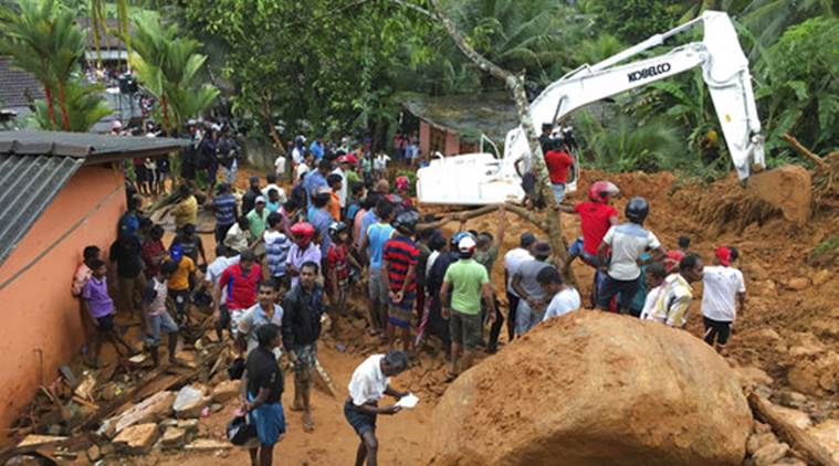
Locals gather to watch rescue operation in Bellana village in Kalutara district, Sri Lanka, Friday. 

At least 25 people were killed and 42 went missing in Sri Lanka due to floods and mudslides caused by torrential rainfall on Friday. A team of 400 soldiers have been rushed to the rescue of over 7,800 people who have been affected by the calamity.

Sri Lanka, Lanka landslide, Lanka mudslide, Lanka flood, lanka flood deaths, Lanka rainfall, Lanka news, latest news, world news, indian express news
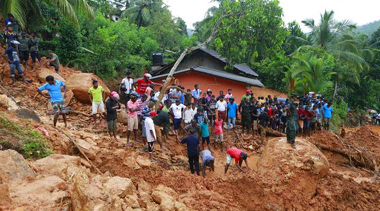
Sri Lankans watch military rescue efforts at the site of a landslide in Bellana village in Kalutara district, Sri Lanka, Friday, May 26, 2017. 

According to a Reuters report, at least five landslides have been reported in Kaluthara, which is the worst-hit district on the west coast of the Lankan island. This is the time of the year when the island nation witnesses highest rainfall, from the month of May to September. As the rescue operations continue, Home Affairs Minister Vajira Abeywardana has issued a warning that the situation can worsen in the next 72 hours,

Comment by M. Difato on May 23, 2017 at 1:51pm

Massive landslide covers Highway 1 in southern Big Sur (May20)

 http://www.montereyherald.com/article/NF/20170522/NEWS/170529949

Big Sur >> Caltrans said Monday its unclear how long Highway 1 in southern Big Sur will remain closed after a landslide covering between a quarter and a half mile brought millions of cubic yards of dirt and rock down the hillside at Mud Creek on Saturday.

According to Caltrans spokeswoman Susana Cruz, there are five active landslides in the area, which is about 9 miles north of the southern Monterey County border. It’s believed four of the slides came down together at about 9:30 p.m. Saturday. Springs in the area keep the soil muddy, she said.

“There was so much saturation and so much weight,” Cruz said..."

http://www.msn.com/en-ca/weather/topstories/landslide-on-california...

SEARCH PS Ning or Zetatalk

 
Search:

This free script provided by
JavaScript Kit

Donate

Donate to support Pole Shift ning costs. Thank you!

© 2024   Created by 0nin2migqvl32.   Powered by

Badges  |  Report an Issue  |  Terms of Service