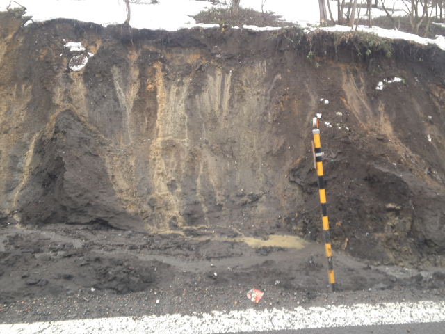
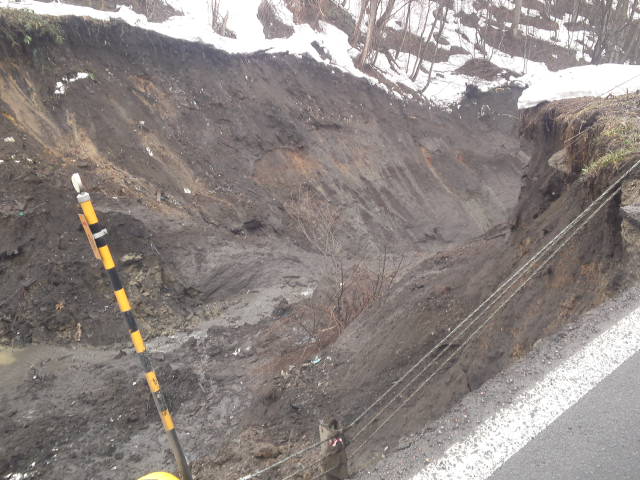
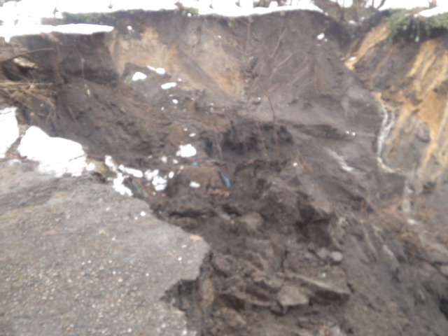
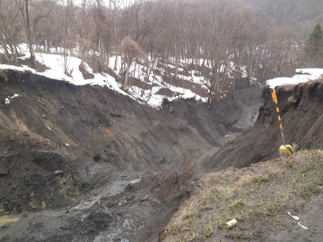
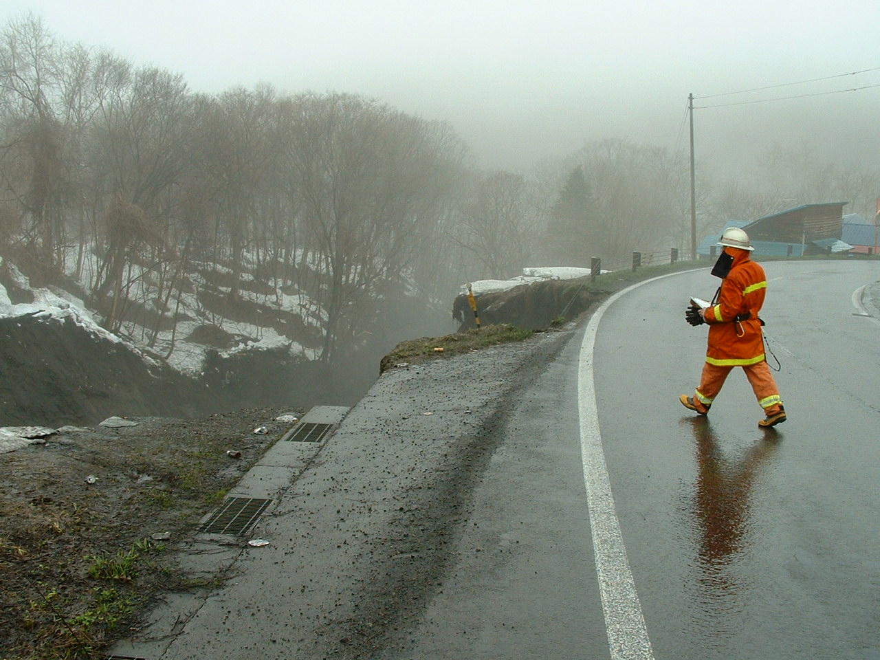
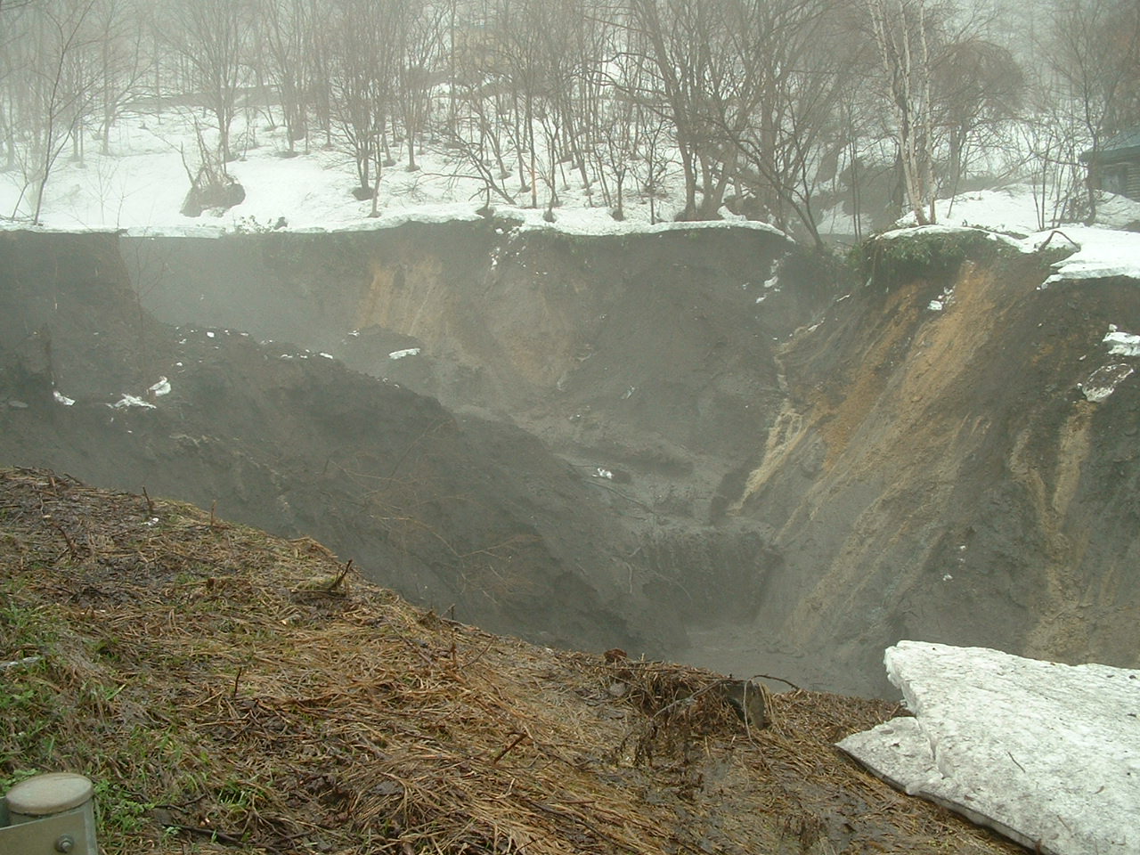
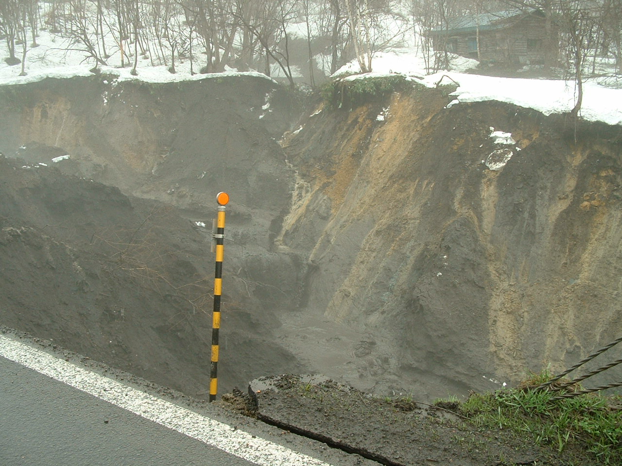
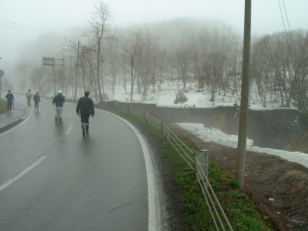
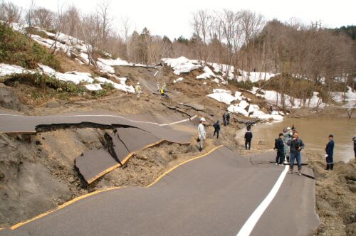
The landslide had taken away the earth and sand of totally about 60,000 cubic meters including the roadside of Akabira-Naie line which has been stopped by Hokkaido Prefectural Government. The white line on the photo is to divide the area for pedestrians and automobiles.
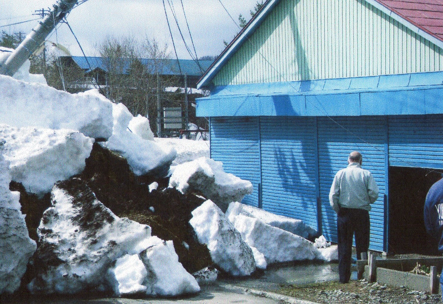
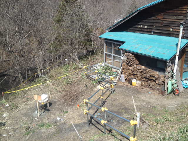
A part of the roadside fence is suspended in the air.
More rainfall will expand the area of landslide but it will be overcast on April 25(Wed.) in this area, the Meteorological Agency of Japan forecasted.
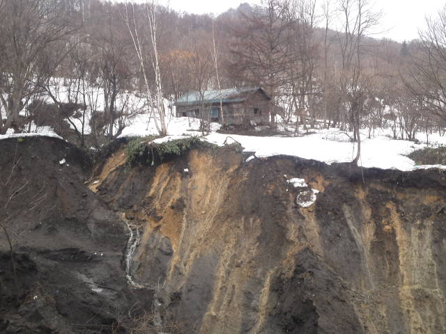
Nobody is living in this house, the municipality of Utashinai confirmed.
In this 3 or 4 days, many parts of Sorachi sub-prefectural area were covered with fog from the ground. It may be moisture evaporated from the ground. Tremendous amount of water is stocked under the ground after the heavy snow in this area. Please be careful with such sign and steep slopes in Sorachi sub-prefectural area.
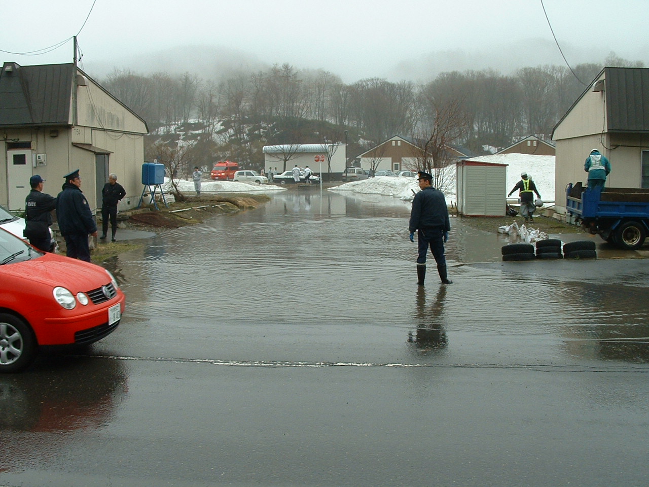
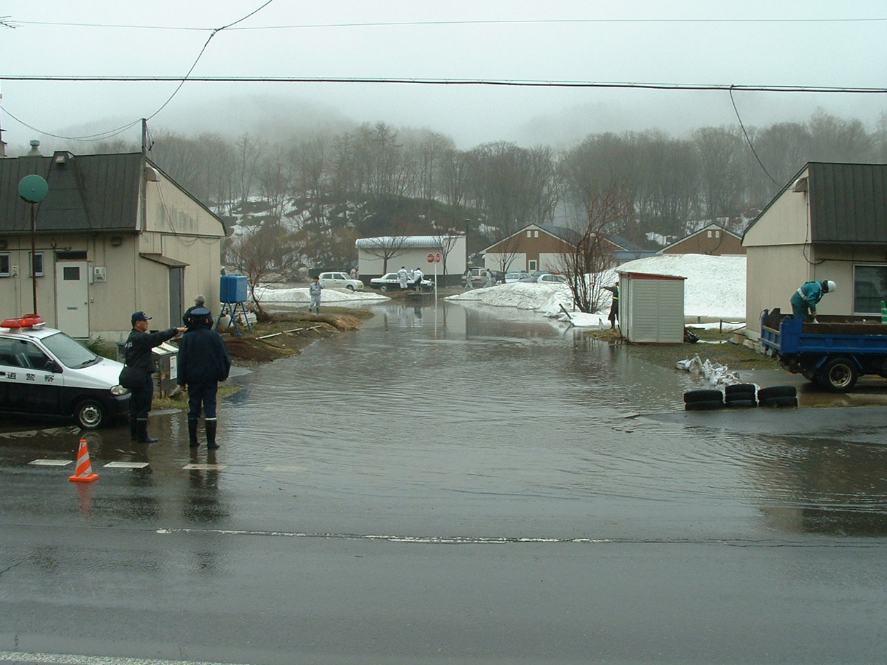
These photos will not on the newspaper tomorrow morning. These were taken in the morning today. The roadside of Akabira-Naie line administered by Hokkaido Prefectural Government and the around area toppled down in the morning of April 24(Tue.) in Utashinai City that had almost gone bunkrupted 6 years ago.
Allegedly the area had been an informal gabage dam where the citizens and their neighbours had thrown in their gabage many years ago. Actually when I walked around the top of the cliff, I felt the touch of plastics and bynyl sheets on the surface.
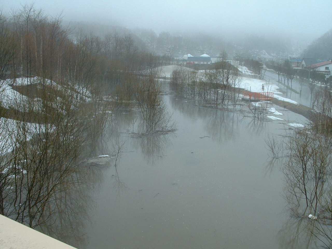
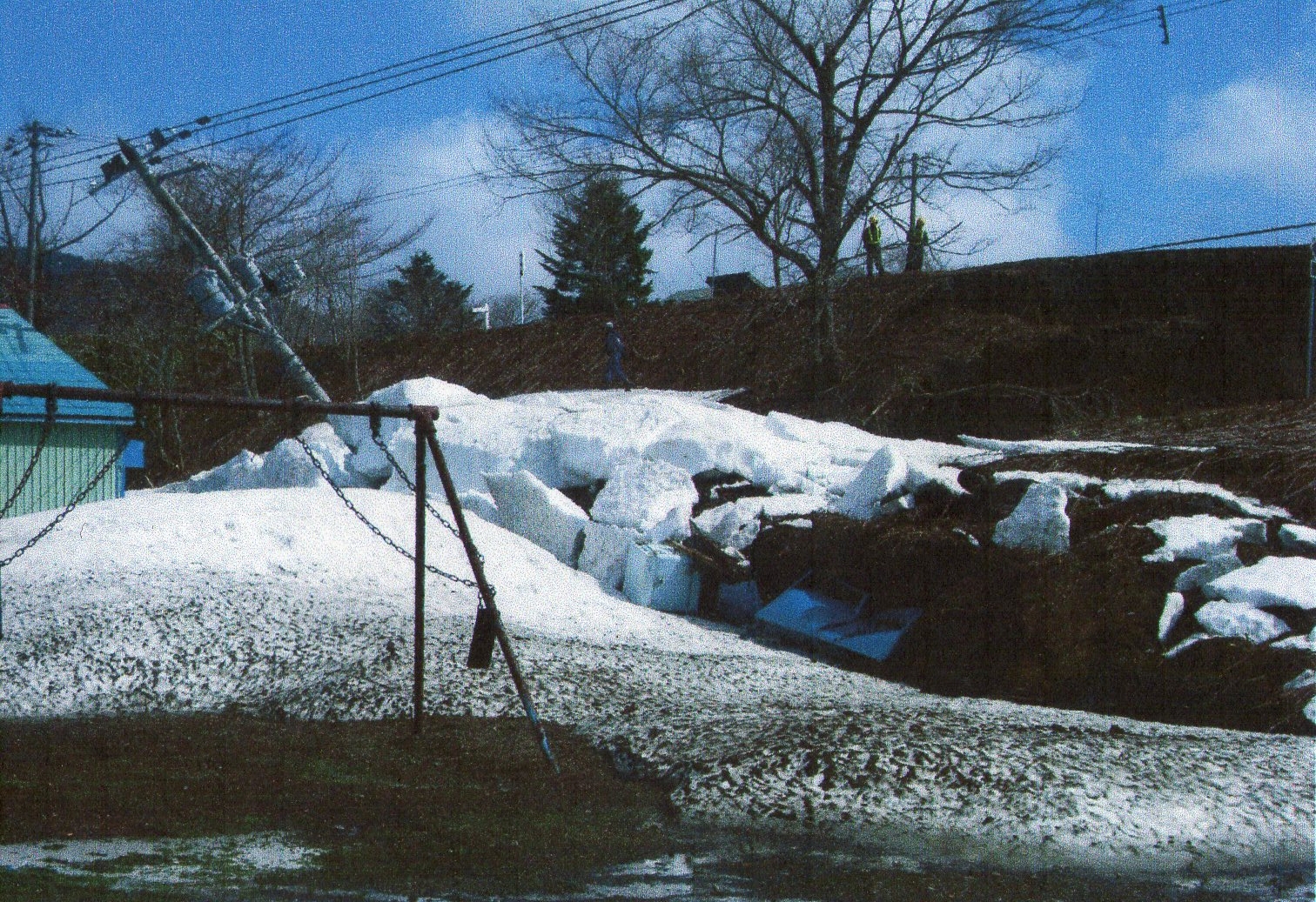
These area was hit by heavy snow in passing winter and had not-so-heavy rainfall these days. The land slide occurred after 8:40 in the morning when one of the neighbours walked around this area. After that one of the citizen made a phone call to the police in Utashinai City at 8:58 in the morning and told that the water of the river Panke-utashinai had got muddy and the landslide had stopped the river flow and caused flood around this area. The depth of the canyon the landslide of 100 meters made was 25 meter in depth and 50 meters in width.
Some houses are around the cliff the landslide made and 197 citizens were evacuated from their house.
Of course the traffic on the road Akabira-Naie line had been stoppedbecause of the fear of more landslide from the upperside.
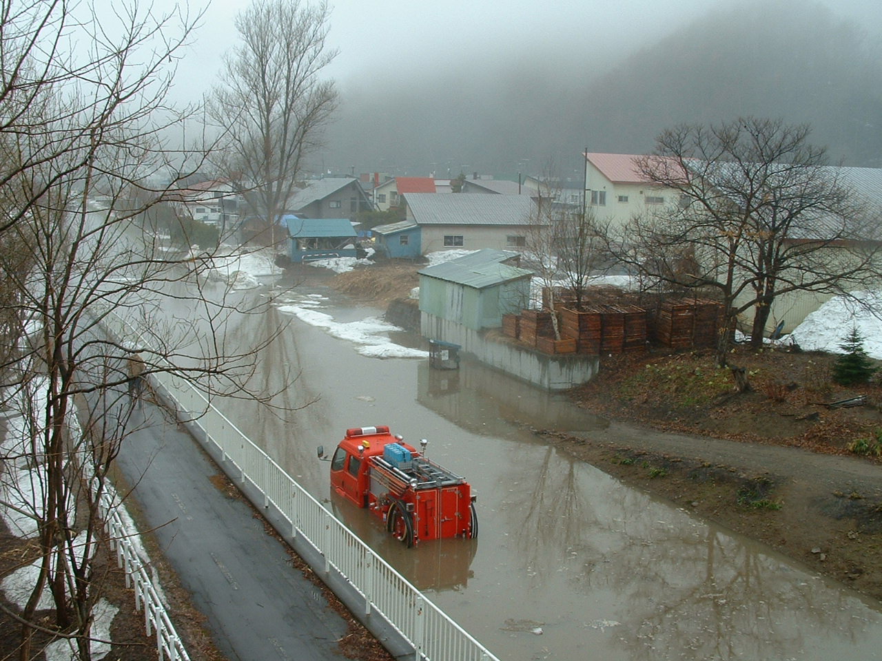
This is the temporary lake made by the land slide.
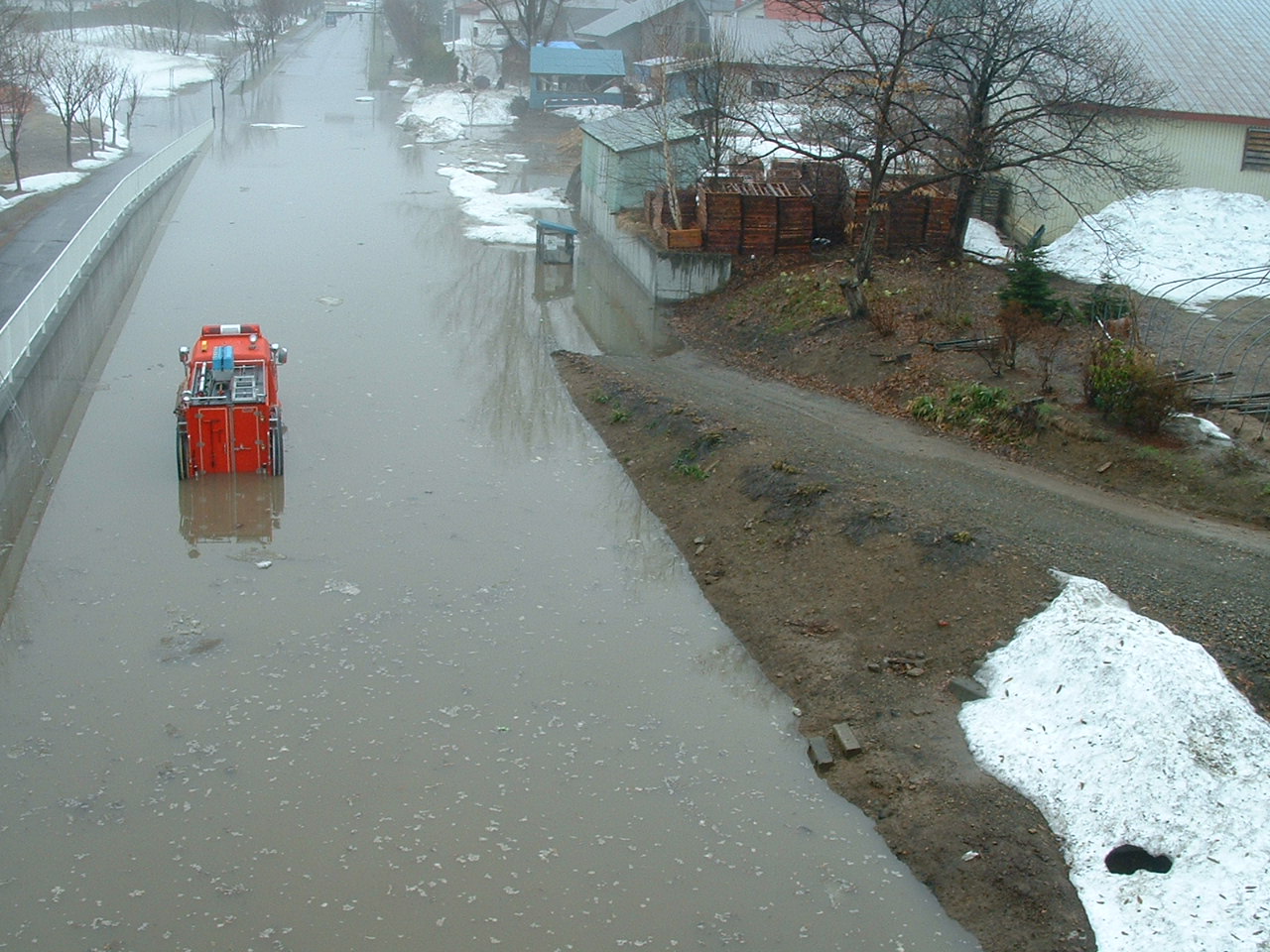
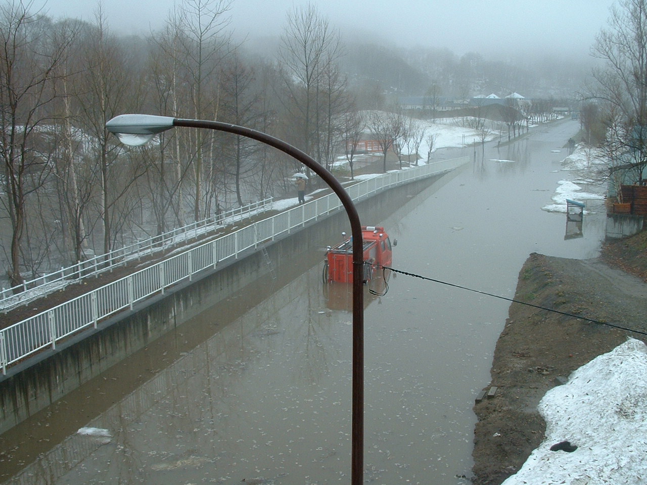
The water in the lake went across the road and swamped to the other side of the road. A fire engine stood still for a while swamped by the water from the river.
I hope the firefighters in Utashinai City will be able to use this fireengine again.
But the muffler was completely under the water at the time.
The apartment buildings run by the city were near the river Pnke-Utashinai.
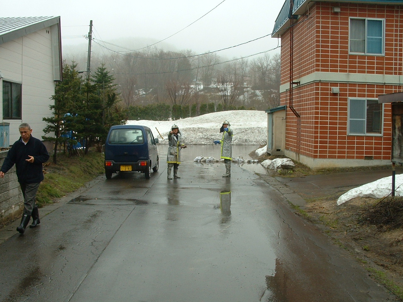
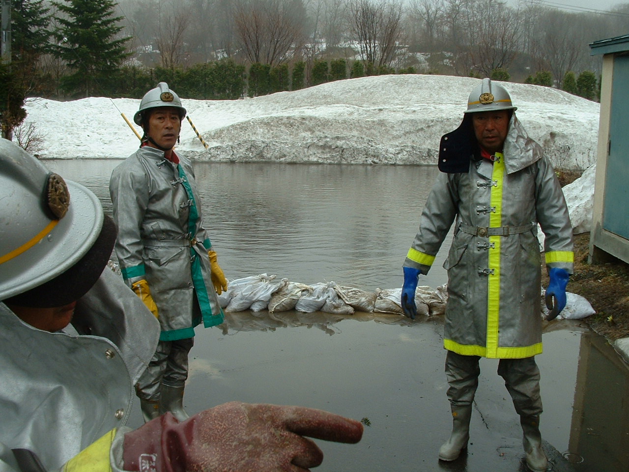
The firefighters were struggle with the water and flood.
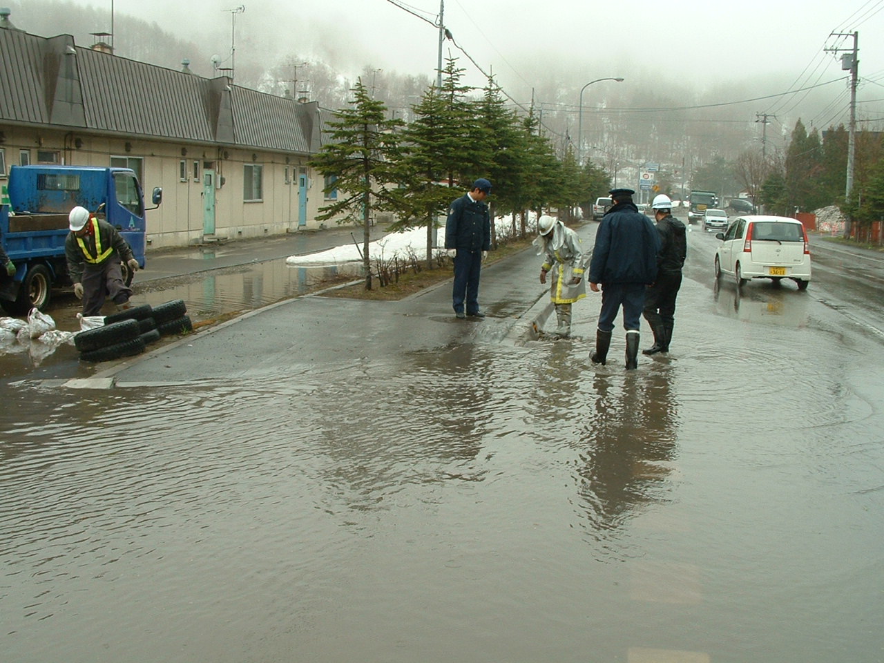
The flood water was pumped out from the residence area soon.
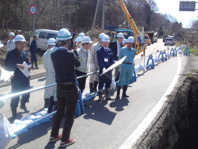
It is required to cooperate each other among the administrative organization such as municipality, prefectural government and self-defence force in Japan.
This flood may be a piece of cake in comparison with the huge earthquake and OOTSUNAMI taht had happened in eastern part of Japan on March of 2011 but we have to build up the strong communities and system to protect the citizens from the disasters.
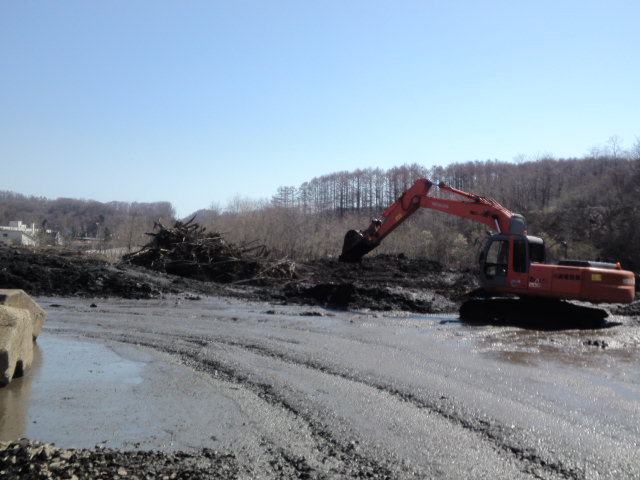
After the backhoes provided by the construction companies in Utashinai City took off the mud in the river that had stopped the river flow, the flood water was pumped out and the water swamped to the town was decreasing.
Thanks to the good communication among the municipality, Japanese Self-defence Force, police, firefighters and the Sub-prefectural Office of Hokkaido Government, no casualty in Utashinai City and around the area. Thanks God ! To be continued.
The site where a massive landslide occurred under a local railway is pictured in Yubari, Hokkaido, on April 27. (Mainichi)
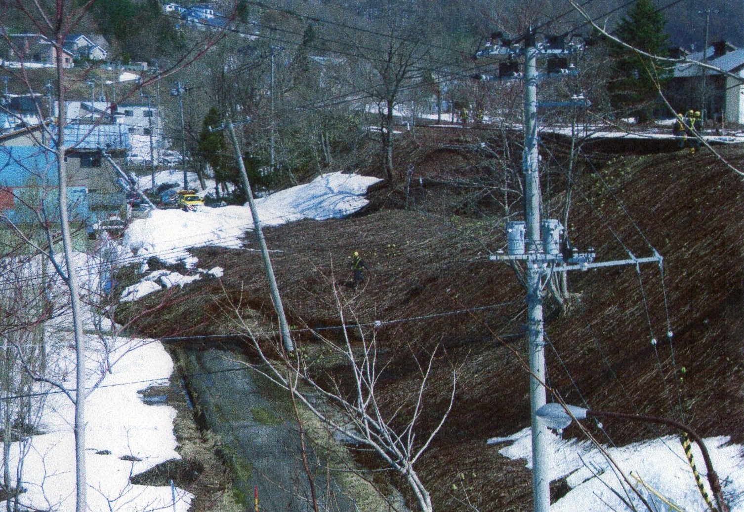
YUBARI, Hokkaido -- Services on a train line here have been seriously disrupted after a massive landslide along a railway embankment, probably due to snowmelt, left part of the line's tracks hanging in the air.
According to Hokkaido Railway Co. (JR Hokkaido) officials, the driver of a local train on the JR Sekisho Line reported experiencing "a vertical shake" at around 7:10 a.m. on April 27, when it was passing between Yubari and Shikanotani stations.
The landslide, which swept the earth out from under the tracks for some 50 meters, reaching a nearby municipal road, is presumed to have occurred shortly after the train passed by, officials say.
Although there were no injuries as a result of the incident reported, the Yubari Municipal Government issued evacuation advisories to five households near the accident site.
Services between the Sekisho Line's Yubari and Shin-Yubari stations remained suspended for the day.
The landslide is presumed to be the result of sudden snowmelt in the area, due in turn to recent higher-than-normal temperatures, officials say.
According to the Sapporo District Meteorological Observatory, on the day of the incident, at 16.5 degrees Celsius temperatures in Yubari were closer to the mid-May average than late April. While there was accumulated snow of some 25 centimeters only a day earlier, on the morning of April 27 the snow had melted down to only about three centimeters.
In related news, a series of landslides and river overflows also presumed to have been caused by snowmelt occurred in various places in Hokkaido on the same day.
Landslides that choked local canals and causing partial flooding on roads occurred in Asahikawa and Shosanbetsu in central and northwestern Hokkaido, respectively, while an overflow of the Uryu River in Fukagawa and Numata, both in western Hokkaido, inundated some 5,000 square meters of rice paddies along the river.
JR Hokkaido temporarily suspended services between Horonobe and Teshionakagawa stations on the Soya Line in central and northern Hokkaido due to an alarming rise in the Teshio River.
As a result of the incidents, JR Hokkaido began emergency inspections of past landslide locations and places where snowmelt water had previously gathered. The checkups are expected to continue until April 29.
The new ZetaTalk for 5/5 includes a question on this issue, so here it is a tad early.
SOZT
Hokkaido Island of Japan is subject to pressure from the subduction of the Pacific Plate, which creates mountain building deep below with consequent rumpling of the land above. Rumpling can be described as portions rising while other portions drop and roll, like the waves arriving on a beach and turning upon themselves at the return to the ocean. Earthquakes are frequently described as having the appearance of waves rolling along the land, the land rising and falling. If the wave is large enough, the portions rising and the portions dropping and rolling have enough difference in height to cause the landscape to tear apart, as was seen in Hokkaido.
On 5/4/2012 5:34:09 AM UTC an earthquake of magnitude 4.6 and depth 95.4km has struck an moderately populated area in the Hokkaido Province(population: 5.8 million) in Japan. GDACS estimates the likelihood for need of international humanitarian intervention to be low (Green alert).
This earthquake can have a low humanitarian impact since the affected region is moderately populated and has high resilience for natural disasters.
The earthquake 10km from the city of Nemuro. The nearest populated places are Svetloye (11km), Atsutoko (20km), Nishi-wada (8km), Fushiko-tobuto (8km), Tomoshiri (14km), Bekkai (17km). It is a mountainous region with a maximum altitude of 1430 m.
Tokyo(ANN)-Hokkaido's Pacific coast may be hit by tsunami as high as 35 metres if a massive earthquake strikes near Hokkaido, according to an interim report by an expert panel at the Hokkaido Disaster Management Council.
The experts, led by Minoru Kasahara, a professor emeritus at Hokkaido University, raised the maximum predicted magnitude of an earthquake near Hokkaido from 8.6 to 9.1 based on sediments collect from past tsunami.
As a result, the maximum height of the tsunami could be as high as 35.1 metres at Tokachi Port in Hiroo, Hokkaido. The figure exceeds the Cabinet Office's 34.4-metre predicted height for a tsunami in Kuroshio, Kochi Prefecture, in the event of a massive quake in the Nankai Trough.
According to the projections, a tsunami of 30 metres or higher could strike five towns in Hokkaido, while a tsunami between 20 metres and 30 metres could hit another six cities and towns, including Kushiro.
In the panel's simulations, the epicentral area of the massive earthquake was estimated to be in areas off northern Sanriku to the Nemuro coast. It is presumed that a magnitude-8 earthquake will occur about every 500 years at the boundary of the tectonic plate extending from areas off Tokachi to areas off Nemuro.
The study panel plans to release its final report in about one or two months after making more precise predictions.
The Hokkaido government had previously predicted that the largest possible earthquake would have a magnitude of 8.6 and trigger a tsunami with a maximum height of 22 metres.
However, based on lessons learned from the Great East Japan Earthquake, institutions have begun forecasting the worst possible earthquakes that may occur once every several hundreds of years, or every 1,000 years.
The Hokkaido prefectural government panel started reviewing its tsunami predictions in June last year. The central government is also reviewing its projections for a massive earthquake expected in the Nankai Trough.
I happened in Yubari City. The heavy snow in winter and the water flow under the ground caused the landslide in Yubari City. It took away the earth and sand under the railroad. The railroad wll be recovered in a few days and evacuated people will be allowed by the municipality to go back to their home. Japan Railway System in Hokkaido provided the evacuated residents with free drink and stay in the hotel near Mt.Reisui .
Old buildings that no one lives in were swamped by the heavy snow, earth and sands. Japan Railway System in Hokkaido is probing and clutching the numbers to settle the problem. Allegedly the citizens in Yubari City will be able to use the train of this line by May 2(Wed.) and before that the evacuated residents in this area will be allowed to go back to their home.
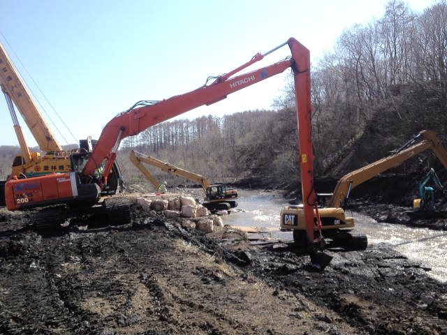
This is the place where the landslide stopped th waterflow of the river and caused floods in Monju area of Utashinai City on April 24(Tue.) and earth and sand have been taken away with the long-arm back-hoes. Lefthand side is the crane to set the concrete block at the bank of the river to prevent more landslide go into the river and to stop the waterflow.
This is the back-hoe of normal type.
Compared to the back-hoe of normal type, the bucket of this long-arm back-hoe is much smaller. The size is one forth of normal type because the longer the arm is, the more difficult to operate and keep the balance of the machine. That means it requires hgher degrees of skill to operate the long-arm back-hoe and much more time is necessary to have done the same amount of workload. The operator of this long-arm back-hoe was so tired of the consecutive operation to recover the waterflow and bank protection works around the clock. Another seasoned operator of the back-hoe was throw into this work to accelerate the going of the work.
After taking off the extra earth and sand, the long-arm back-hoe began to flatten the bank to set the concrete blocks. At 15:30 of today, evacation of this area was canceled becaude no more landslide will expected in this area and water-supply system had recovered.
It can be said that the operation of this long-arm back-hoe is a kind of artistic creation to save the people and make the future. It took my breath away for a while.
This house is near the area of landslide and a part of the premises were lost this time.
The member of House of Representatives, Mr.Hisashi Inatsu visited the area in the morning today and stood on the cliff the landslide had made on April 24. He listened to the explanation of the officers of Hokkaido Government and recognized the serious situation in this area enough, I think. After the record heavy snow in Sorachi sub-prefectural area, landslides began to annoy the residents and the local government staff. Even in Yubari City that had gone bankruptcy six years ago, the earth under the railroad was swamped with water and taken away. The fences of the road to protect pedestrians are suspended in the air even now. I hope no more floods this year because in 1981 Ishikari River overflowed because of the heavy snowfall in winter and heavy rain is summer. Actually it happened. Please cross the fingers and toes for your safety in Sorachi sub-prefectural area.
180 km S Sapporo (pop 1,883,027 ; local time 03:41:19.5 2012-04-27) 96 km E Hakodate (pop 275,730 ; local time 03:41:19.5 2012-04-27) 54 km NE Mutsu (pop 49,220 ; local time 03:41:19.5 2012-04-27)
Population Density near epicenter (people/km2). Image area: 5x3.5 decimal degrees (approx. 550x400km2).
On 4/21/2012 2:29:37 PM UTC an earthquake of magnitude 4.8 and depth 94.4km has struck an moderately populated area in the Hokkaido Province(population: 5.8 million) in Japan. GDACS estimates the likelihood for need of international humanitarian intervention to be low (Green alert).
This earthquake can have a low humanitarian impact since the affected region is moderately populated and has high resilience for natural disasters.
The earthquake 94km from the city of Sapporo. The nearest populated places are Atsugacho (15km), Mombetsu (18km), Kawamukai (20km), Sarufuto (16km), Showa (6km), Biratori (16km), Hobiboe (15km). It is a mountainous region with a maximum altitude of 1866 m.


You need to be a member of Earth Changes and the Pole Shift to add comments!
Join Earth Changes and the Pole Shift