EARTHQUAKES Worldwide! (Frequently Updated)

Global Earthquake Maps

ANF

EMSC

Global Incident Map

IRIS

SNNC

USGS

Regionally Specific Earthquake Maps

Australia

Canada

Germany

Japan

Iceland


Related Informations:


Earthquakes during the poleshift

Earth Wobble

Wobble effect

TT - Earth Wobble

Deep Quakes

Quake Swarms

Pre-Shift Quakes

Magnetic twist and the effects

Wobble sloshing

Scripted Drama

Quake charts


Additional Information from the F.A.Q:

Q: What is the "Earth Wobble"?
A: https://poleshift.ning.com/forum/topics/explaining-the-earth-wobble


Q: How can I understand the Magnetosphere?

- About the Magnetosphere
- What the graphs on the Magnetosphere Simulation mean


Q: Is there a relationship between disturbances in the magnetosphere and seismic activity?
- Magnetosphere Deformations and Earth Wobble Effects
- Approach to Earthquake Prediction from the Magnetosphere Simulation
- Analysis try; Earthquakes/plate movement and magnetosphere simula...

Altering Earthquakes:

ZetaTalk Aug 7, 2010

As of late, I have observed that USGS and EMSC are a bit lax on their reports of earthquakes. Sometimes not seeing anything reported for hours from the last update, or seeing periods of 90-200 minutes with no earthquakes in between. My question is, are they leaving swarms of earthquakes out of their reports, or there are actually periods of no earthquakes?

SOZT:   Greater than 90% of the earthquake activity is being altered by the USGS at present, which is under orders to prevent any clue being given to the public about the Earth changes caused by the presence of Planet X. Over a decade ago, the approach was to de-sensitize the live seismographs periodically, so the displays do not turn black worldwide, and to ignore the twice-a-day patterns showing up on these seismographs. Then any quakes that could be dropped were dropped. This was obvious to some who were watching the database manipulation. Quakes in the list would suddenly disappear. This was particularly the case where a quake happened in a remote location, or out in the ocean. Dumbing down the magnitude quickly followed, but in order to ensure the public did not notice, the USGS took control of all websites reporting quake statistics. At times, this control breaks, and discrepancies are reported to the public. Some countries rebel. Quake swarms are another source of control, as they pepper the databases with many quakes and skew the statistics, and thus are pulled from the database. Else the question is raised, why so many?   EOZT


ZetaTalk Jun 18, 2011

Will the USGS internet system be a reliable warning system for the European tsunami by registering on the net the New Madrid earthquake on the exact time it occurs?

SOZT:   It will not be a lack of information from the USGS that will be the point of confusion during the earthquakes leading up to the New Madrid adjustment, it will be knowing which quake is the big one vs the many minor quakes preceding it. The USGS downgrades almost all earthquakes, to prevent meaningful statistics from being generated from their databases. They also exclude quakes whenever they can, but this is unlikely to happen in the New Madrid area as it is in the center of a populated land mass. Thus you will have magnitude 6 quakes that will be called a 5.2, magnitude 7 quakes called a 6.1, and when a magnitude 8 or greater quake occurs, it will be called a 6.9.

We would advise that rather than watching the USGS quake statistics, that you watch the Earth changes. The adjustment that will incite the European tsunami will involve bridges on the Mississippi breaking, and being impassable. The land to the west of the Mississippi will drop so that the Mississippi will become 50 miles wide in the state of Mississippi. Watch for this. The New Madrid adjustment will be several large quakes of magnitude 8-9, though will be listed as a lesser magnitude. As the N American continent continues to unzip up to and along the Seaway, the quakes will be less than a magnitude 8 but very destructive to Cleveland and Toledo and Buffalo and the inland locks along the Seaway. Thus it is not what the USGS says that should be watched, but the condition of the bridges on the Mississippi, the impact on the cities along the Seaway, and whether the inland locks are reported as inoperable.   EOZT


Please collect earthquake-reports here. Significant Quakes or Magnitude 7+ can be posted separately.

[Edited by the Moderation]


Views: 547971

Comment

You need to be a member of Earth Changes and the Pole Shift to add comments!

Join Earth Changes and the Pole Shift

Comment by Carlos on July 26, 2013 at 11:58pm

6.2  2013/07/26  21:32:59 (UTC) 57.789°S 23.959°W 10.0km (6.2Miles) 203 KM NE OF BRISTOL ISLAND, SOUTH SANDWICH ISLANDS 

http://earthquake.usgs.gov/earthquakes/eventpage/usc000iq6f#summary

Comment by Carlos on July 26, 2013 at 9:49am

6.2 2013/07/26  07:07:17 (UTC)  15.362 S  167.584 E  135.5 Km (82.4 Miles)  48 KM ENE OF LUGANVILLE, VANUATU

http://earthquake.usgs.gov/earthquakes/eventpage/usc000ipje#summary

Comment by Chris Harris on July 25, 2013 at 11:34pm

Magnitude 5.2 quake off North Queensland coast, Australia, as recorded by the New Caledonia Seismic Centre:

Comment by Howard on July 24, 2013 at 5:40am

China Dispatches Thousands of Rescuers for 5.9 Quake (July 23)

While USGS rated yesterday's devastating quake at 5.9, China dispatched thousands of police, soldiers and government officials to search for survivors of the earthquake that struck the northwestern province of Gansu.

To date, nearly 100 have been killed, over 1,000 injured, 31,600 moved to temporary shelters, about 22,500 homes damaged and 2,000 homes completely destroyed.

China Earthquake Networks Center maintains the quake magnitude was 6.6

Sources

http://www.bloomberg.com/news/2013-07-22/earthquake-in-china-s-gans...

http://www.ctvnews.ca/world/northwest-china-quake-toll-continues-to...

Comment by jorge namour on July 24, 2013 at 4:31am

The earthquakes today in the Mediterranean basin: the strongest shock in Greece
Tuesday, July 23, 2013, 23:49

earthquakes_europe They are little more than 50 earthquakes with magnitude greater than 2.0 recorded today in the Mediterranean area. This is borne out by the data of the European-Mediterranean Seismological Centre.

In today's day, up to 21 hours, the quake was the strongest recorded in the islands of the Dodecanese (Greece). The earthquake had a magnitude of 3.5. Another earthquake of magnitude 3.4 occurred in Crete.

Other earthquakes, all with magnitudes between 2.0 and 3.0, were recorded in western Turkey, Albania, in the region of Cyprus, in the Ionian Sea, the Aegean Sea and the Strait of Gibraltar. In Italy, the recorded earthquakes today have taken place over the Apuan Alps (magnitude 2.0) in the southern Tyrrhenian Sea off the north coast of Sicily (2.6) and in the Adriatic Sea off the coast of Ancona (magnitude 3.0 in the evening), two days after the strong earthquake that has rocked the region.

http://translate.google.com.ar/translate?sl=it&tl=en&js=n&a...

2013-07-24 02:09:26 21.23 S 68.18 W 186 3.8 POTOSI, BOLIVIA
2013-07-24 01:59:53 30.73 S 71.66 W 46 3.4 COQUIMBO, CHILE
2013-07-24 01:47:2 28.37 N 129.85 E 10 4.6 RYUKYU ISLANDS, JAPAN
2013-07-23 23:32:20.02hr33.44 S 72.00 W 27 3.1 OFFSHORE VALPARAISO, CHILE
2013-07-23 22:36:48. 20.26 S 70.90 W 2 4.3 OFFSHORE TARAPACA, CHILE
2013-07-23 21:30:18. 20.28 S 70.75 W 8 4.4 OFFSHORE TARAPACA, CHILE
2013-07-23 21:12:19.05h 20.27 S 70.77 W 8 4.5 OFFSHORE TARAPACA, CHILE
2013-07-23 20:16:21.06hr 20.32 S 70.74 W 5 4.5 OFFSHORE TARAPACA, CHILE
2013-07-23 20:11:15.66 41.67 S 174.22 E 21 4.0 COOK STRAIT, NEW ZEALAND
2013-07-23 20:10:20.06h 20.21 S 70.85 W 22 3.5 OFFSHORE TARAPACA, CHILE
2013-07-23 19:35:27.06hr 7.90 S 129.56 E 73 4.7 KEPULAUAN BABAR, INDONESIA
2013-07-23 17:27:14.0 20.20 S 70.74 W 8 4.7 OFFSHORE TARAPACA, CHILE
2013-07-23 16:45:09.09 35.18 S 71.07 W 108 3.4 MAULE, CHILE
2013-07-23 16:44:44.0 23.39 S 67.19 W 249 3.9 ANTOFAGASTA, CHILE
2013-07-23 15:59:29.0 54.53 N 167.42 E 20 4.9 KOMANDORSKIYE OSTROVA REGION
2013-07-23 14:52:59. 18.61 S 69.87 W 96 3.5 TARAPACA, CHILE
2013-07-23 10:35:28.0 54.32 N 165.58 W 47 4.6 FOX ISLANDS, ALEUTIAN ISLANDS
2013-07-23 09:48:51.4 8.93 S 78.51 W 78 4.6 NEAR COAST OF NORTHERN PERU
2013-07-23 09:18:08.0 42.01 N 133.06 E 476 4.1 PRIMOR'YE, RUSSIA
2013-07-23 08:24:40.1 44.21 N 84.42 E 14 3.9 NORTHERN XINJIANG, CHINA
http://www.emsc-csem.org/Earthquake/?view=1

NEW ZEALAND- A map of earthquakes in the Cook Strait region since Friday 19 July.
http://info.geonet.org.nz/display/home/Cook+Strait+Earthquakes

2013-07-24 00:30:41.41 17.37 S 167.54 E 35 4.9 VANUATUEMSC
http://www.emsc-csem.org/Earthquake/earthquake.php?id=327138
24/07/2013 00:29:58 6.3 Vanuatu Islands Region N: CALEDONIA SITE
http://sismo.ird.nc/index.php?option=com_alertes&view=alertes&a...
24/07/2013 02:13:11 5.4 Vanuatu Islands Region
http://sismo.ird.nc/index.php?option=com_alertes&view=alertes&a...

Comment by jorge namour on July 23, 2013 at 3:44am

2013-07-22 22:51:05.02hr 1.30 S 15.83 W 10 5.1 NORTH OF ASCENSION ISLAND
http://www.emsc-csem.org/Earthquake/earthquake.php?id=327017
2013-07-22 22:19:13 1.39 S 15.85 W 33 4.8 NORTH OF ASCENSION ISLAND
2013-07-22 22:15:11.0 1.29 S 15.99 W 10 5.2 NORTH OF ASCENSION ISLAND
http://www.emsc-csem.org/Earthquake/earthquake.php?id=327008

Magnitude mb 5.2
Region NORTH OF ASCENSION ISLAND
Date time 2013-07-22 22:15:11.0 UTC
Location 1.29 S ; 15.99 W
Depth 10 km
Distances 1018 km SW of Monrovia, Liberia / pop: 939,524 / local time: 22:15:11.0 2013-07-22
1123 km S of Freetown, Sierra Leone / pop: 802,639 / local time: 22:15:11.0 2013-07-22
1224 km S of Conakry, Guinea / pop: 1,767,200 / local time: 22:15:11.0 2013-07-22

http://www.emsc-csem.org/#2

Comment by Chris Harris on July 23, 2013 at 2:47am

Magnitude 6.0 quake in New Caledonia as recorded by the New Caledonia Seismic Centre:

Comment by jorge namour on July 22, 2013 at 4:12pm

2013-07-22 13:54: 26.75 S 69.78 W 10 5.5 ATACAMA, CHILE
http://www.emsc-csem.org/Earthquake/earthquake.php?id=326980

2013-07-22 12:32:57.7 35.28 S 54.07 E 10 5.0 SOUTH INDIAN OCEAN
http://www.emsc-csem.org/Earthquake/earthquake.php?id=326973

2013-07-22 04:50:3 5.89 N 127.17 E 100 4.7 PHILIPPINE ISLANDS REGION

2013-07-22 00:14:28.7 55.95 N 61.23 E 10 4.5 URAL MOUNTAINS REGION, RUSSIA
http://www.emsc-csem.org/Earthquake/earthquake.php?id=326904

2013-07-22 00:05:10.0 61.77 S 58.67 W 68 5.3 SOUTH SHETLAND ISLANDS
http://www.emsc-csem.org/Earthquake/earthquake.php?id=326935

2013-07-22 00:03:14.3 47.02 S 69.75 W 21 5.4 SANTA CRUZ, ARGENTINA
http://www.emsc-csem.org/Earthquake/earthquake.php?id=326910

2013-07-22 07:30:37. 43.33 N 13.14 E 24 2.2 CENTRAL ITALY
2013-07-22 07:26:48.06 43.34 N 13.14 E 25 2.2 CENTRAL ITALY
2013-07-22 07:24:24 43.34 N 13.14 E 25 2.1 CENTRAL ITALY
2013-07-21 15:24:23.0 43.53 N 13.72 E 9 2.5 CENTRAL ITALY
2013-07-21 14:53:20.0 43.56 N 13.85 E 9 2.0 CENTRAL ITALY
2013-07-21 14:45:01.0 43.61 N 13.98 E 10 2.2 CENTRAL ITALY
2013-07-21 14:03:29.0 43.56 N 13.76 E 8 2.0 CENTRAL ITALY
2013-07-21 12:19:22.0 43.50 N 13.72 E 8 2.8 CENTRAL ITALY
2013-07-21 07:44:49.0 43.53 N 13.82 E 9 2.6 CENTRAL ITALY
2013-07-21 07:11:26.0 43.58 N 13.96 E 6 2.1 CENTRAL ITALY SWARM
2013-07-21 01:32:24.0 43.53 N 13.74 E 5 5.0 CENTRAL ITALY

http://www.emsc-csem.org/Earthquake/earthquake.php?id=326769
Magnitude Mw 5.0
Region CENTRAL ITALY
Date time 2013-07-21 01:32:24.0 UTC
Location 43.53 N ; 13.74 E
Depth 5 km
Distances 208 km NE of Roma, Italy / pop: 2,563,241 / local time: 03:32:24.0 2013-07-21
20 km E of Ancona, Italy / pop: 100,507 / local time: 03:32:24.0 2013-07-21

http://www.emsc-csem.org/Earthquake/?view=1

Comment by Tracie Crespo on July 22, 2013 at 2:45pm

New update on the China "6.6" quake.

http://worldnews.nbcnews.com/_news/2013/07/22/19602512-china-earthq...=

China earthquake reportedly kills 75, collapses many homes

Chinese state media are reporting this morning that at least 75 people were killed and nearly 300 injured after a 6.6 magnitude earthquake shook western China.

A 6.6-magnitude earthquake struck central China on Monday, reportedly killing at least 75 people and collapsing many homes.

The U.S. Geological Survey said the quake hit in Gansu province about eight miles east of Chabu at 7:45 a.m. Beijing time (7:45 p.m. ET Sunday). The USGS recorded it at 6 miles deep and said it caused shaking in a rural region where the infrastructure isn't seismically resistant.

State news agency Xinhua said the death toll had risen to 75. It put the number of people injured at 600. 

China Daily via Reuters

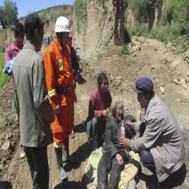
A man gives water to an injured woman after an earthquake hit Minxian county in China's Gansu province on Monday.

Photos posted on Chinese social media showed roads on the sides of riverbanks  that had subsided and farmhouses reduced to piles of red bricks, Reuters reported.

"Many have been injured by collapsed houses," a doctor  surnamed Du told Reuters.

The official China Meteorological Administration warned that heavy rain was possible in southeastern Gansu province Monday night and into Tuesday. It said the rain could hamper rescue efforts and urged residents to be alert to flash flooding in areas damaged by the earthquake.

About 5,600 residential buildings were damaged, the Beijing-based China Daily newspaper reported Monday afternoon. Some train service was suspended, and hundreds of armed police were mobilized to repair a damaged part of the main highway linking Lanzhou, the provincial capital, to Minxian county, it reported.

Bing Maps

Xinhua said the quake was felt in the neighboring cities of Dingxi, Longnan and Tianshui, as well as Lanzhou, more than 100 miles away. About 19,000 people live in the area that was subject to the strongest shaking, it said.

The quake was followed an hour and a half later by a 5.6-magnitude quake at about the same depth, the USGS reported.

Based on the history of earthquakes of this size in rural China, there could be "significant casualties," the USGS said.

Gansu abuts Sichuan province, where a 6.6 quake in April killed 164 people and injured more than 6,700, China's worst quake in three years.

NBC News' Li Le, Sarah Burke and Alastair Jamieson contributed to this report.

This story was originally published on

Comment by Carlos on July 22, 2013 at 10:54am

6.1  2013/07/22  07:01:42 (UTC)  46.042 S  34.825 E  10 Km (6.2 Miles)  244 KM WNW OF MARION ISLAND, PRINCE EDWARD ISLANDS.

http://earthquake.usgs.gov/earthquakes/eventpage/usb000ijj6#summary

SEARCH PS Ning or Zetatalk

 
Search:

This free script provided by
JavaScript Kit

Donate

Donate to support Pole Shift ning costs. Thank you!

© 2024   Created by 0nin2migqvl32.   Powered by

Badges  |  Report an Issue  |  Terms of Service