EARTHQUAKES Worldwide! (Frequently Updated)
 Global Earthquake Maps
Regionally Specific Earthquake Maps
|
Related Informations:
Earthquakes during the poleshift Magnetic twist and the effects
|
Additional Information from the F.A.Q: Q: What is the "Earth Wobble"?
Q: How can I understand the Magnetosphere? - About the Magnetosphere
Q: Is there a relationship between disturbances in the magnetosphere and seismic activity? |
Altering Earthquakes:
As of late, I have observed that USGS and EMSC are a bit lax on their reports of earthquakes. Sometimes not seeing anything reported for hours from the last update, or seeing periods of 90-200 minutes with no earthquakes in between. My question is, are they leaving swarms of earthquakes out of their reports, or there are actually periods of no earthquakes?
SOZT: Greater than 90% of the earthquake activity is being altered by the USGS at present, which is under orders to prevent any clue being given to the public about the Earth changes caused by the presence of Planet X. Over a decade ago, the approach was to de-sensitize the live seismographs periodically, so the displays do not turn black worldwide, and to ignore the twice-a-day patterns showing up on these seismographs. Then any quakes that could be dropped were dropped. This was obvious to some who were watching the database manipulation. Quakes in the list would suddenly disappear. This was particularly the case where a quake happened in a remote location, or out in the ocean. Dumbing down the magnitude quickly followed, but in order to ensure the public did not notice, the USGS took control of all websites reporting quake statistics. At times, this control breaks, and discrepancies are reported to the public. Some countries rebel. Quake swarms are another source of control, as they pepper the databases with many quakes and skew the statistics, and thus are pulled from the database. Else the question is raised, why so many? EOZT
Will the USGS internet system be a reliable warning system for the European tsunami by registering on the net the New Madrid earthquake on the exact time it occurs?
SOZT: It will not be a lack of information from the USGS that will be the point of confusion during the earthquakes leading up to the New Madrid adjustment, it will be knowing which quake is the big one vs the many minor quakes preceding it. The USGS downgrades almost all earthquakes, to prevent meaningful statistics from being generated from their databases. They also exclude quakes whenever they can, but this is unlikely to happen in the New Madrid area as it is in the center of a populated land mass. Thus you will have magnitude 6 quakes that will be called a 5.2, magnitude 7 quakes called a 6.1, and when a magnitude 8 or greater quake occurs, it will be called a 6.9.
We would advise that rather than watching the USGS quake statistics, that you watch the Earth changes. The adjustment that will incite the European tsunami will involve bridges on the Mississippi breaking, and being impassable. The land to the west of the Mississippi will drop so that the Mississippi will become 50 miles wide in the state of Mississippi. Watch for this. The New Madrid adjustment will be several large quakes of magnitude 8-9, though will be listed as a lesser magnitude. As the N American continent continues to unzip up to and along the Seaway, the quakes will be less than a magnitude 8 but very destructive to Cleveland and Toledo and Buffalo and the inland locks along the Seaway. Thus it is not what the USGS says that should be watched, but the condition of the bridges on the Mississippi, the impact on the cities along the Seaway, and whether the inland locks are reported as inoperable. EOZT
Please collect earthquake-reports here. Significant Quakes or Magnitude 7+ can be posted separately.
[Edited by the Moderation]
Views: 548041
Comment
-
Comment by jorge namour on August 7, 2013 at 1:03am
-
SOUTH & CENTRAL AMERICA :: Last 48 hours ::
CHILE, ARGENTINA, PERU, COLOMBIA, PANAMA, NICARAGUA, GUATEMALA
*Source: EMSC Interactive EarthQuake MAP & LIST
http://www.emsc-csem.org/Earthquake/Map/zoom.php?key=4&typ=worl...
2013-08-06 21:05:39.0 20.11 S 69.12 W 90 2.4 TARAPACA, CHIL
2013-08-06 20:17:31.02hr 14min ago 17.05 N 98.27 W 10 5.1 GUERRERO, MEXICOFELT
http://www.emsc-csem.org/Earthquake/earthquake.php?id=328864
2013-08-06 20:16:37.2 36.56 N 30.00 E 9 2.2 WESTERN TURKEY SWARM2013-08-06 17:21:58.0516.64 S 167.58 E 30 5.5 VANUATU
2013-08-06 16:46:21 16.74 S 167.52 E 10 5.9 VANUATU
http://www.emsc-csem.org/Earthquake/earthquake.php?id=3288482013-08-06 17:04:21.0hr 27min ago 4.04 S 137.45 E 20 4.8 PAPUA, INDONESIA
2013-08-06 16:14:10. 32.48 N 86.73 E 80 4.8 WESTERN XIZANG
2013-08-06 15:31:21 31.46 N 86.56 E 2 5.2 WESTERN XIZANG
http://www.emsc-csem.org/Earthquake/earthquake.php?id=3288392013-08-06 15:02:33.07hr 36.07 N 120.64 W 7 3.6 CENTRAL CALIFORNIA
http://www.emsc-csem.org/Earthquake/earthquake.php?id=3288362013-08-06 14:11:52 26.50 N 124.91 E 200 4.8 NORTHEAST OF TAIWAN
2013-08-06 13:21:39.09 19.81 S 69.96 W 55 4.1 TARAPACA, CHILE
2013-08-06 13:06:37. 5.55 S 152.36 E 38 4.6 NEW BRITAIN REGION, P.N.G.2013-08-06 13:01:1 22.66 S 173.78 E 80 5.0 SOUTHEAST OF LOYALTY ISLANDS
2013-08-06 10:41:38.011hr 50min ago 22.54 S 173.76 E 60 5.7 SOUTHEAST OF LOYALTY ISLANDS
http://www.emsc-csem.org/Earthquake/earthquake.php?id=3287922013-08-06 10:34:22.011 44.42 N 10.69 E 29 2.8 NORTHERN ITALY
2013-08-06 07:33:36.2 32.90 N 47.69 E 8 3.6 IRAN-IRAQ BORDER REGION
2013-08-06 07:11:13.0 52.85 N 160.17 E 49 4.5 OFF EAST COAST OF KAMCHATKA
2013-08-06 07:03:31.0 44.72 N 10.19 E 11 2.3 NORTHERN ITALY
2013-08-06 06:42:42.0 44.70 N 10.20 E 11 2.0 NORTHERN ITALY
2013-08-06 06:41:13.0 44.68 N 10.28 E 10 2.5 NORTHERN ITALY2013-08-06 05:57:43.0 14.27 N 91.43 W 60 5.5 GUATEMALA
2013-08-06 05:36:57.0 41.95 N 29.60 W 10 4.4 AZORES ISLANDS REGION
2013-08-06 02:50:10.0 7.27 N 77.21 W 10 4.9 PANAMA-COLOMBIA BORDER REGI
2013-08-06 01:47:01.8 62.32 S 155.11 E 10 4.8 BALLENY ISLANDS REGION
http://www.emsc-csem.org/Earthquake/earthquake.php?id=3288012013-08-05 20:49:15.2 30.57 N 113.88 W 10 4.0 GULF OF CALIFORNIA
http://www.emsc-csem.org/Earthquake/earthquake.php?id=328808
2013-08-05 16:18:19.0 62.28 S 155.26 E 10 4.8 BALLENY ISLANDS REGION2013-08-06 00:08:32.0 24.04 S 67.56 W 206 4.1 ANTOFAGASTA, CHILE
2013-08-05 15:42:40.0 22.45 S 67.75 W 201 3.0 POTOSI, BOLIVIA
2013-08-05 15:42:27.8 11.57 N 86.40 W 77 4.1 NEAR COAST OF NICARAGUA
2013-08-05 15:02:53.0 19.38 S 169.21 E 80 4.9 VANUATU
2013-08-05 14:38:53.0 18.67 N 144.65 E 30 4.8 PAGAN REG., N. MARIANA ISLAND
2013-08-05 11:24:04.0 15.88 S 75.28 W 10 4.7 NEAR COAST OF CENTRAL PERU2013-08-05 07:34:00.0 1.57 N 31.07 E 30 4.6 LAKE ALBERT REGION, UGANDA
http://www.emsc-csem.org/Earthquake/earthquake.php?id=328671
2013-08-05 06:02:35.4 1.61 N 31.16 E 10 4.6 LAKE ALBERT REGION, UGANDA2013-08-05 07:29:39.0 19.67 S 69.35 W 96 4.4 TARAPACA, CHILE
2013-08-05 06:46:06.0 38.41 S 73.78 W 15 4.6 OFFSHORE ARAUCANIA, CHILE
2013-08-05 06:42:58.0 23.89 S 67.29 W 202 4.3 SALTA, ARGENTINA
2013-08-05 06:15:47.0 3.72 N 126.77 E 40 4.9 KEPULAUAN TALAUD, INDONESIA2013-08-05 04:28:05.0 11.88 N 58.02 E 10 4.8 OWEN FRACTURE ZONE REGION
http://www.emsc-csem.org/Earthquake/earthquake.php?id=328649
2013-08-05 02:39:37.0 37.43 N 24.68 W 5 3.0 AZORES ISLANDS REGION
2013-08-04 21:38:43.0 36.98 N 56.30 E 2 4.2 NORTHEASTERN IRAN
2013-08-04 20:47:52.0 45.46 N 26.29 E 110 3.4 ROMANIA
2013-08-04 19:16:50.0 1.47 N 127.28 E 100 4.7 HALMAHERA, INDONESIA
2013-08-04 18:48:25.0 17.49 S 174.60 W 158 4.5 TONGA2013-08-04 15:56:34.0 47.05 N 145.31 E 375 5.6 SEA OF OKHOTSK
http://www.emsc-csem.org/Earthquake/earthquake.php?id=3285902013-08-04 15:27:39.0 32.50 S 71.80 W 35 4.2 OFFSHORE VALPARAISO, CHILE
2013-08-04 09:53:10.7 36.54 N 70.53 E 194 4.3 HINDU KUSH REGION, AFGHANISTAN2013-08-03 09:19:51.0 53.08 N 162.45 W 18 4.1 SOUTH OF ALASKA
2013-08-03 02:34:26.0 25.05 S 112.10 W 10 5.0 EASTER ISLAND REGION2013-08-02 19:12:51.0 36.72 N 43.33 E 6 3.1 IRAQ
2013-08-02 02:12:57.0 36.58 N 43.38 E 4 3.3 IRAQ
2013-08-02 01:10:31.0 36.68 N 43.27 E 2 4.2 IRAQ FELT
http://www.emsc-csem.org/Earthquake/earthquake.php?id=3283232013-08-01 20:01:44.0 15.30 S 173.55 W 30 6.0 TONGA
http://www.emsc-csem.org/Earthquake/earthquake.php?id=328298
http://www.emsc-csem.org/Earthquake/?view=1M 4.5 - SOUTH OF KERMADEC ISLANDS
Tuesday August 06, 2013 at 16:05 UTC
Location: 34.19 °S 179.88 °W
Depth: 181 Km
http://www.facebook.com/l.php?u=http%3A%2F%2Fsismo.ird.nc%2Findex.p...August 2
Etna volcano (Italy): again earthquakes under eastern flank
http://www.volcanodiscovery.com/etna/news.html
A cluster of earthquakes of magnitudes 2-3 occurred yesterday under the eastern flank near Sant Alfio, at depths around 7-8 km.
https://www.facebook.com/VolcanoMonitorAugust 2
Tjörnes Fracture Zone (Iceland): earthquake swarm
http://www.volcanodiscovery.com/iceland/tjoernes-fracture-zone/news...
A (probably tectonic) swarm of earthquakes has been occurring since yesterday in the eastern part of the TFZ, about 10-15 km north of the shore at various depths mostly below 15 km. It includes more than 100 quakes yesterday including 6 above magnitude 3 (up to 3.8 yesterday morning).
https://www.facebook.com/VolcanoMonitor2013-08-02 02:32:47.0 33.33 N 75.99 E 10 5.2 EASTERN KASHMIR
-
Comment by Chris Harris on August 5, 2013 at 12:35am
-
Comment by Tracie Crespo on August 4, 2013 at 4:34pm
-
http://rt.com/news/fukushima-japan-earthquake-impact-014/
Fukushima shaken by 6.0 magnitude quake
Published time: August 04, 2013 07:56 Edited time: August 04, 2013 11:40
A strong undersea earthquake has hit the same northeastern region of Japan that was devastated by a deadly 2011 tsunami. No damage or injuries have been reported in the affected area, including the Fukushima prefecture.
The 6.0 magnitude earthquake struck off the coast of Miyagi prefecture on Sunday. The epicenter was 50 kilometers below the seabed. No tsunami warning was issued by the Japan Meteorological Agency.
Some roads and railways were, however, temporarily closed for safety checks, according to NHK TV broadcaster, cited by AP.
The quake struck at approximately the same location where a 9.0 magnitude earthquake hit in March 2011, triggering a massive tsunami which led to multiple meltdowns at the Fukushima nuclear plant. Over 15,000 people died as a result of the natural disaster and more than 3,200 went missing.
The Fukushima reactors were not impacted by the tremors on Sunday, according to Tokyo Electric Power Co. (TEPCO), which runs the facility. Another nuclear power plant in the earthquake-hit area, the Onagawa facility in Miyagi prefecture, has also reported no damages.
Following the meltdowns of two and a half years ago, crews at the Fukushima nuclear plant have been struggling hard to clear up the damage done by the natural disaster. TEPCO has recently acknowledged that one of the problems it cannot solve is that crippled reactors continue to leak highly contaminated radioactive waters into the Pacific Ocean. The process of decommissioning the reactors is likely to take several decades, and according to recent estimates, it is going to cost Japan up to $58 billion.
-
Comment by KM on August 4, 2013 at 4:01pm
-
http://www.globalincidentmap.com/beta/quakes-map
Incident Type: Magnitude 5
Country:
Place: Vancouver Island, Canada region
Date/Time (UTC): 2013-08-04 13:22:28
Severity/Importance: Severe
Infrastructure Affected: Unknown
Permanent link to this event: http://www.globalincidentmap.com/beta/quakes-map/event/220855
Source: usgs.gov
Rating:Popularity: 0/5 (0 votes cast)Magnitude: 5.7
Depth: 10.00
NST: 115
Source: USGS Feedhttp://www.huffingtonpost.ca/2013/08/04/vancouver-island-earthquake...
Vancouver Island Earthquake Registers 5.7 Magnitude
CP | By The Canadian Press Posted: 08/04/2013 10:40 am EDT | Updated: 08/04/2013 1:20 pm EDT
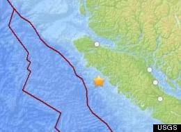 A Vancouver Island earthquake about 108 kilometres south of Port Hardy was felt slightly, but no damage or injuries were reported Sunday morning. (U.S. Geological Survey)
PORT HARDY, B.C. - A "moderate" quake shook the northern end of Vancouver Island early Sunday morning, waking many people in their beds as windows rattled and blinds swayed from the tremors.
Earthquakes Canada said the 5.5 magnitude quake hit at about 6:20 a.m. local time about 25 kilometres west of Nootka Island, off the north coast of Vancouver Island.
-
-
2013-08-04 01:28:26 48.96 S 8.69 W 10 5.4 SOUTHERN MID-ATLANTIC RIDGE
http://www.emsc-csem.org/Earthquake/earthquake.php?id=328528
http://www.emsc-csem.org/#2
-
Comment by Carlos on August 1, 2013 at 10:44pm
-
5.8 2013/08/01 20:01:41 (UTC) 15.282 S 173.444 W 17.0 Km (10.6 Miles) 80 KM NNE OF HIHIFO, TONGA
http://earthquake.usgs.gov/earthquakes/eventpage/usb000itmf#summary
-
-
M 4.9 - COOK STRAIT, NEW ZEALAND
Wednesday July 31, 2013 at 23:10 UTC
Location: 41.56 S, 174.39 E
Depth: 16km
http://www.emsc-csem.org/Earthquake/earthquake.php?id=328195
another : Magnitude 4.2, Thursday, August 1 2013 at 11:55:39 am
geonet list M 4.2 at 5km depth: http://geonet.org.nz/quakes/region/newzealand/2013p572964
NZST: Thursday, August 1 2013 at 1:15:48 pm
Intensity: moderate
Depth: 9 km
Magnitude: 3.3
Location: 30 km south of Seddon
http://www.geonet.org.nz/quakes/region/newzealand/2013p573115
NZST: Thursday, August 1 2013 at 11:55:39 am
Intensity: moderate
Depth: 18 km
Magnitude: 4.2
Location: 30 km east of Seddon
http://www.geonet.org.nz/quakes/region/newzealand/2013p572964
NZST: Thursday, August 1 2013 at 10:57:08 am
Intensity: light
Depth: 13 km
Magnitude: 3.3
Location: 25 km east of Seddon
http://www.geonet.org.nz/quakes/region/newzealand/2013p572855
NZST: Thursday, August 1 2013 at 10:33:42 am
Intensity: moderate
Depth: 6 km
Magnitude: 3.4
Location: 25 km east of Seddon
NZST: Thursday, August 1 2013 at 10:33:42 am
Intensity: moderate
Depth: 6 km
Magnitude: 3.4
Location: 25 km east of Seddon
NZST: Thursday, August 1 2013 at 9:23:43 am
Intensity: light
Depth: 17 km
Magnitude: 3.1
Location: 15 km north-east of Seddon
http://www.geonet.org.nz/quakes/region/newzealand/2013p572679
NZST: Wednesday, July 31 2013 at 11:17:28 pm
Intensity: moderate
Depth: 9 km
Magnitude: 3.4
Location: 10 km south-east of Seddon
http://www.geonet.org.nz/quakes/region/newzealand/2013p571541 SWARM
M 4.5 - OFF E. COAST OF N. ISLAND, NEW ZEALAND
Wednesday July 31, 2013 at 10:43 UTC
Location: 36.89 S, 179.04 E
Depth: 14 km
http://www.geonet.org.nz/quakes/feltNZST: Tuesday, July 30 2013 at 6:27:42 am
Intensity: weak
Depth: 155 km
Magnitude: 4.6
Location: 25 km north-east of White Island
http://www.geonet.org.nz/quakes/region/newzealand/2013p5669442013-08-01 01:00:16 43.51 N 12.10 E 10 2.2 CENTRAL ITALY
2013-07-31 23:51:33.01h 43.51 N 12.10 E 10 2.6 CENTRAL ITALY 35.73 N 26.31 E 30 3.4 CRETE, GREECE
2013-07-31 22:09:05.0 26.72 N 57.72 E 2 3.9 SOUTHERN IRAN
2013-07-31 21:04:32.04hr 27.47 S 69.59 W 120 3.2 ATACAMA, CHILE
2013-07-31 19:44:31.06h 51.06 N 178.30 E 10 5.2 RAT ISLANDS, ALEUTIAN ISLANDS
2013-07-31 17:26:48.48hr 39.33 N 29.05 E 6 2.4 WESTERN TURKEY SWARM
2013-07-31 16:33:12.09hr 44.93 N 143.18 E 236 4.5 HOKKAIDO, JAPAN REGION
2013-07-31 16:23:19.0 5.96 S 147.50 E 68 4.6 EASTERN NEW GUINEA REG., P.N.G.
2013-07-31 14:52:47.3 8.23 N 126.37 E 51 4.6 MINDANAO, PHILIPPINES
2013-07-31 14:01:14 24.28 S 111.86 W 33 4.9 EASTER ISLAND REGION
http://www.emsc-csem.org/Earthquake/earthquake.php?id=328157
2013-07-31 10:36:22.0 36.63 N 21.49 E 49 4.4 SOUTHERN GREECE
2013-07-31 10:28:09.9 5.13 S 80.64 W 48 4.8 NEAR COAST OF NORTHERN PERU
2013-07-31 10:25:22.0 8.55 S 80.16 W 35 4.5 OFF COAST OF NORTHERN PERU
2013-07-31 09:51:16.0 38.08 N 15.62 E 10 2.1 SICILY, ITALY
2013-07-31 09:31:08.0 46.69 N 10.65 E 10 2.8 NORTHERN ITALY
2013-07-31 08:35:59.0 41.68 N 142.54 E 47 4.5 HOKKAIDO, JAPAN REGION
2013-07-31 05:40:51.0 36.61 N 142.73 E 10 5.0 OFF EAST COAST OF HONSHU, JAPAN
2013-07-31 05:35:56.0 20.56 S 67.94 W 200 4.3 POTOSI, BOLIVIA
2013-07-31 05:22:38.0 23.04 S 67.32 W 248 4.2 ANTOFAGASTA, CHILE
2013-07-31 00:36:56.0 1.39 N 126.30 E 47 5.0 MOLUCCA SEA
2013-07-31 00:14:14.0 38.13 N 142.03 E 10 5.1 NEAR EAST COAST OF HONSHU, JAPAN
2013-07-30 21:31:03.0 3.56 S 137.25 E 93 4.5 PAPUA, INDONESIA
2013-07-30 19:31:30.8 19.58 N 104.94 W 97 4.1 JALISCO, MEXICO
2013-07-30 17:27:45.0 16.41 N 94.21 W 100 4.5 OAXACA, MEXICO
2013-07-30 15:12:19.1 15.21 S 71.56 W 120 4.2 SOUTHERN PERU
2013-07-30 13:29:59.0 15.83 N 92.89 W 112 5.2 CHIAPAS, MEXICO
2013-07-30 12:58:33.0 45.14 N 15.09 E 20 4.5 CROATIA
http://www.emsc-csem.org/Earthquake/earthquake.php?id=328057
2013-07-30 12:48:47.0 35.54 S 104.12 W 10 4.8 SOUTHEAST OF EASTER ISLAND
http://www.emsc-csem.org/Earthquake/?view=131/07/2013 16:38:12 36.7275 -12.7433 50 4.5 mb AZORES-CABO DE SAN VICENTE
http://www.geo.ign.es/ign/layoutIn/sismoDetalleTerremotos.do?evid=1...
31/07/2013 16:00:33 36.5032 -9.9001 51 4.0 mb SW CABO DE SAN VICENTE
-
-
2013-07-30 09:25:1 40.29 N 25.79 E 10 3.1 AEGEAN SEA
2013-07-30 07:48: 40.31 N 25.77 E 8 3.0 AEGEAN SEA
2013-07-30 07:03:11. 40.28 N 25.96 E 25 3.3 AEGEAN SEA
2013-07-30 06:51 40.30 N 25.88 E 5 3.1 AEGEAN SEA
2013-07-30 06:48:03.0 40.31 N 25.90 E 8 3.2 AEGEAN SEA
2013-07-30 06:38:06.0 40.32 N 25.80 E 10 3.2 AEGEAN SEA
2013-07-30 06:28:07.0 40.27 N 25.82 E 10 4.0 AEGEAN SEA
2013-07-30 06:24:4 40.30 N 25.71 E 2 3.1 AEGEAN SEA
2013-07-30 05:53:14.04 40.31 N 25.81 E 5 3.1 AEGEAN SEA
2013-07-30 05:42:10.04 40.29 N 25.86 E 2 3.3 AEGEAN SEA
2013-07-30 05:33:09.04 40.32 N 25.88 E 10 4.9 AEGEAN SEA2013-07-30 09:12 22.03 S 67.56 W 211 3.3 POTOSI, BOLIVIA
2013-07-30 09:07: 37.67 N 28.83 E 7 2.3 WESTERN TURKEY
2013-07-30 07:21:20 41.55 S 74.15 W 11 3.9 OFFSHORE LOS LAGOS, CHILE
2013-07-30 04:59:10.05h 5.45 S 152.08 E 50 4.8 NEW BRITAIN REGION,
2013-07-30 04:53:28.05hr 36.14 S 73.57 W 32 3.6 OFFSHORE BIO-BIO, CHILE
2013-07-30 02:53:58.07h 28.02 N 139.78 E 508 4.4 BONIN ISLANDS, JAPAN REGION
2013-07-30 02:13:59 38.68 N 17.92 E 10 3.4 SOUTHERN ITALY
2013-07-30 01:45:13.08 44.16 N 10.18 E 3 2.7 NORTHERN ITALY
2013-07-30 01:23:42.9 52.00 N 160.02 E 50 4.0 OFF EAST COAST OF KAMCHATKA
2013-07-30 01:22:51.08 18.05 S 178.44 W 582 4.5 FIJI REGION
2013-07-30 00:55:13.09 38.44 N 15.39 E 134 2.4 SICILY, ITALY
2013-07-29 23:32:37.01 36.18 S 73.72 W 26 3.3 OFFSHORE BIO-BIO, CHILE
2013-07-29 22:56:10.011h23.63 N 126.02 E 10 4.9 SOUTHEAST OF RYUKYU ISLANDS
2013-07-29 22:55:27.511 46.80 N 141.53 E 5 3.7 SAKHALIN, RUSSIA
2013-07-29 21:33:36.0 36.78 N 71.24 E 250 4.6 HINDU KUSH REGION, AFGHANISTAN
2013-07-29 20:56:15.0 23.92 S 67.48 W 228 4.2 ANTOFAGASTA, CHILE2013-07-29 18:27:41.0 37.51 S 177.33 E 157 5.0 OFF E. COAST OF N. ISLAND, N.Z.
http://www.emsc-csem.org/Earthquake/earthquake.php?id=327909
2013-07-29 04:37:49.0 42.67 S 172.65 E 9 4.4 SOUTH ISLAND OF NEW ZEALAND
2013-07-28 13:07:14.0 41.66 S 174.27 E 15 4.9 COOK STRAIT, NEW ZEALAND
http://www.emsc-csem.org/Earthquake/earthquake.php?id=327742
NZST: Monday, July 29 2013 at 9:44:41 pm
Intensity: moderate
Depth: 16 km
Magnitude: 4.1
Location: 30 km east of Seddon
http://www.geonet.org.nz/quakes/region/newzealand/2013p565962
NZST: Monday, July 29 2013 at 4:37:49 pm
Intensity: strong
Depth: 9 km
Magnitude: 4.7
Location: 20 km north-west of Culverden
http://www.geonet.org.nz/quakes/region/newzealand/2013p565386
http://www.geonet.org.nz/quakes/felt2013-07-29 14:53:33.0 24.61 N 62.50 E 20 4.6 OFF COAST OF PAKISTAN
2013-07-29 10:50:59.7 13.84 N 125.01 E 26 4.8 PHILIPPINE ISLANDS REGION
2013-07-29 10:23:35.0 45.94 N 143.07 E 334 4.4 HOKKAIDO, JAPAN REGION
2013-07-29 08:07:59.0 36.55 N 70.66 E 183 5.0 HINDU KUSH REGION, AFGHANIST
2013-07-29 05:49:34.0 4.71 S 105.07 W 10 4.6 CENTRAL EAST PACIFIC RISE
2013-07-29 02:26:32.2 14.29 N 92.87 E 28 4.6 ANDAMAN ISLANDS, INDIA REGIO
2013-07-29 01:43:35.0 5.06 N 94.66 E 60 4.7 NORTHERN SUMATRA, INDONESIA
2013-07-29 01:42:32.0 15.26 S 75.81 W 30 4.5 NEAR COAST OF CENTRAL PERU
2013-07-28 23:14:20.0 17.90 S 178.49 W 590 4.6 FIJI REGION
2013-07-28 21:23:53.0 22.11 S 67.89 W 230 4.0 POTOSI, BOLIVIA
2013-07-28 20:16:27.0 20.61 S 174.59 E 68 5.5 VANUATU REGION
2013-07-28 19:52:03.0 23.20 S 68.68 W 104 4.3 ANTOFAGASTA, CHILE
2013-07-28 17:49:46.0 39.45 N 143.28 E 10 4.8 OFF EAST COAST OF HONSHU, JAPAN
2013-07-28 17:31:57.0 7.34 S 144.87 E 10 4.6 NEAR S COAST OF NEW GUINEA,
2013-07-28 17:29:20.7 23.13 S 68.18 W 115 4.6 ANTOFAGASTA, CHILE
2013-07-28 16:57:34.0 5.71 S 80.68 W 47 4.6 NEAR COAST OF NORTHERN PERU
2013-07-28 15:10:41.7 5.06 S 146.75 E 148 4.5 EASTERN NEW GUINEA REG., P.N.G
2013-07-28 14:25:05.0 45.65 N 26.51 E 81 4.0 ROMANIA
2013-07-28 13:55:36.0 43.10 N 0.54 W 7 2.6 PYRENEESFELT
2013-07-28 13:54:39.0 37.95 N 20.97 E 21 4.2 IONIAN SEA
2013-07-28 12:52:58.4 6.06 N 123.50 E 558 4.6 MORO GULF, MINDANAO, PHILIPPIN
2013-07-28 11:36:00.0 31.08 N 137.92 E 454 5.3 IZU ISLANDS, JAPAN REGION
2013-07-28 08:48:52.0 36.07 S 73.34 W 10 4.6 OFFSHORE BIO-BIO, CHILE
2013-07-28 07:21:04.0 52.28 N 159.66 E 28 5.1 OFF EAST COAST OF KAMCHATKA
2013-07-28 03:51:26.0 40.73 N 15.74 E 8 2.2 SOUTHERN ITALY
2013-07-27 22:22:45.0 36.79 N 70.79 E 200 4.4 HINDU KUSH REGION, AFGHANISTA
2013-07-27 22:18:31.0 6.90 S 131.94 E 45 5.0 KEP. TANIMBAR REGION, INDONESIA
2013-07-27 19:11:03.1 50.40 N 130.13 W 18 4.3 VANCOUVER ISLAND, CANADA REGIOM
http://www.emsc-csem.org/Earthquake/earthquake.php?id=327670
2013-07-27 18:48:31.0 50.34 N 130.26 W 14 3.9 VANCOUVER ISLAND, CANADA REGION
2013-07-27 17:55:10.0 7.43 N 127.07 E 75 4.9 PHILIPPINE ISLANDS REGION
2013-07-27 16:22:51.1 77.12 N 18.94 E 2 4.6 SVALBARD REGION2013-07-29 14:11:40.3 27.70 N 18.16 W 19 2.6 CANARY ISLANDS, SPAIN REGION
2013-07-28 16:22:39.2 27.70 N 18.16 W 21 3.0 CANARY ISLANDS, SPAIN REGION
http://www.emsc-csem.org/Earthquake/earthquake.php?id=327765
2013-07-28 01:40:34.6 27.72 N 18.02 W 11 2.8 CANARY ISLANDS, SPAIN REGIOhttp://www.emsc-csem.org/Earthquake/?view=1
2.5 23km SE of Waimea, Hawaii 2013-07-30 07:18:01 UTC-03:00 24.7 km
4.6 154km NE of Agrihan, Northern Mariana Islands 2013-07-30 05:37:11 UTC-03:00 35.0 km
4.6 North of Ascension Island 2013-07-30 05:13:59 UTC-03:00 10.0 km
http://earthquake.usgs.gov/earthquakes/eventpage/usc000isfq#summary
3.2 5km NNE of East Quincy, California 2013-07-30 00:29:17 UTC-03:00 1.9 km
3.2 13km NW of Glennallen, Alaska 2013-07-29 22:52:26 UTC-03:00 34.3 km
5.2 155km NNE of Bristol Island, South Sandwich Islands 2013-07-29 18:52:12 UTC-03:00 53.5 km
3.7 12km SE of Waimanalo Beach, Hawaii 2013-07-29 17:30:59 UTC-03:00
32.9 km
http://earthquake.usgs.gov/earthquakes/eventpage/hv60534471#summary
http://earthquake.usgs.gov/earthquakes/map/28/07/2013 12:55:50 35.3600 0.2248 22 4.2 mb SE MASCARA.ARGELIA
http://www.02.ign.es/ign/layoutIn/sismoDetalleTerremotos.do?evid=12...
27/07/2013 15:05:24 34.2326 -4.9115 3.6 mb SE L'OULJA.MOROCCO
27/07/2013 05:06:39 34.3034 -4.9035 3.3 mb E L'OULJA MOROCCO
27/07/2013 04:04:57 34.1362 -4.8057 3.5 mb NE FEZ.MOROCCO
http://www.geo.ign.es/ign/layoutIn/sismoListadoTerremotos.do?zona=1...
-
-
http://anf.ucsd.edu/recenteqs/
EQ off Saint Pierre in New Foundland, Canada.
Latitude 46.7606 Longitude -55.3939 Magnitude 4.9 mb Depth 15 km UTC Time 15:07:29 July 29th, 2013 UTC Location Newfoundland, Canada, Eastern North America Author tele Review status -
-
-
EL HIERRO- CANARIAS JULY 27 2013
SMALL REBOUND EARTHQUAKE IN IRON. MAP OF EARTHQUAKES IN THE IRON UPDATED - 27/07/2013 - 9:00 pm Canaries. So far seismicity day on the island of the iron is rebounding, with 12 located earthquakes and so far the day, all in the central interior of the island, divided between the Gulf and the area peaks between 9 and 13km deep. (in purple on the map). AVCAN
http://www.avcan.org/?m=Mapas&a=mapa&mf=60242013-07-27 13:06:01.0 38.89 N 27.48 E 7 3.1 WESTERN TURKEY
2013-07-27 12:14:31. 41.95 N 23.25 E 0 3.0 BULGARIA
http://www.emsc-csem.org/Earthquake/earthquake.php?id=327627
2013-07-27 03:51:22.0 41.97 N 23.17 E 10 3.2 BULGARIA
2013-07-27 03:21:54.010h 41.91 N 23.20 E 2 4.0 BULGARIA
2013-07-27 03:17:00.010 41.93 N 23.18 E 4 3.5 BULGARIA
2013-07-27 01:48:31.01 41.95 N 23.19 E 2 3.6 BULGARIA
2013-07-27 01:24:24.0 41.94 N 23.20 E 2 3.9 BULGARIA
2013-07-27 11:39:04.0 18.23 N 64.24 W 16 3.6 VIRGIN
ISLANDS REGION
2013-07-27 10:44:18.0 22.13 S 68.72 W 112 3.8 ANTOFAGASTA, CHILE
2013-07-27 10:34:45.0 5.41 S 129.43 E 232 4.4 BANDA SEA
2013-07-27 10:34:02.0 34.85 S 71.88 W 75 4.5 MAULE, CHILE
2013-07-27 10:32:06.036.41 S 74.01 W 43 3.8 OFFSHORE BIO-BIO, CHILE
2013-07-27 09:48:01 35.82 N 27.29 E 5 3.4 DODECANESE ISLANDS, GREECE52.31 N 159.67 E 30 4.6 OFF EAST COAST OF KAMCHATKA
2013-07-27 09:04: 40.55 N 142.65 E 60 4.6 NEAR EAST COAST OF HONSHU, JAPAN 17.60 S 69.78 W 130 3.2 SOUTHERN PERU
2013-07-27 07:37:233.06 S 129.90 E 9 4.5 SERAM, INDONESIA
2013-07-27 06:46:44.0 3.11 S 128.03 E 42 4.6 SERAM, INDONESIA
2013-07-27 06:10:46. 19.40 N 64.53 W 51 3.6 VIRGIN ISLANDS REGION
2013-07-27 04:25:25. 18.04 N 64.27 W 1 3.7 VIRGIN ISLANDS REGION
2013-07-27 04:38:32.09 40.14 N 21.84 E 10 4.0 GREECE
2013-07-27 04:24:40.09h 13.22 N 145.43 E 47 5.4 GUAM REGIONFELT
http://www.emsc-csem.org/Earthquake/earthquake.php?id=327570
2013-07-27 01:14:46.7 32.88 N 141.74 E 29 4.6 IZU ISLANDS, JAPAN REGION
2013-07-27 01:09:04.0 33.04 N 141.72 E 43 5.4 OFF EAST COAST OF HONSHU, JAPAN
2013-07-26 23:13:03.0 29.77 S 72.09 W 41 4.1 OFFSHORE COQUIMBO, CHILE
2013-07-26 22:54:56.9 22.93 S 169.92 E 10 4.6 SOUTHEAST OF LOYALTY ISLANDS
2013-07-26 20:38:17.8 66.65 N 158.43 W 10 4.8 NORTHERN ALASKA
2013-07-26 20:37:19.0 58.15 N 151.95 W 30 4.8 KODIAK ISLAND REGION, ALASKA
2013-07-27 01:27:12.0 27.60 N 139.86 E 484 4.2 BONIN ISLANDS, JAPAN REGION
2013-07-27 01:01:28.0 10.16 S 107.35 E 2 4.7 SOUTH OF JAVA, INDONESIA
2013-07-26 16:25:07.0 32.96 N 104.82 E 10 4.8 SICHUAN-GANSU BORDER REG, CHINA
2013-07-26 16:14:01.0 36.36 N 70.21 E 138 4.6 HINDU KUSH REGION, AFGHANISTAN
2013-07-26 14:36:23.0 0.37 S 99.27 E 80 4.9 SOUTHERN SUMATRA, INDONESIA
2013-07-26 13:46:36.5 33.51 N 35.57 E 5 3.1 LEBANON - SYRIA REGION
http://www.emsc-csem.org/Earthquake/earthquake.php?id=327489
2013-07-26 13:28:37.1 25.40 N 125.04 E 111 4.6 SOUTHWESTERN RYUKYU ISL., JAPAN
2013-07-26 12:57:25.0 50.45 N 129.94 W 2 5.0 VANCOUVER ISLAND, CANADA REG
http://www.emsc-csem.org/Earthquake/earthquake.php?id=327474
2013-07-26 10:31:08.0 33.00 N 12.84 W 30 3.2 MADEIRA ISLANDS, PORTUGAL
2013-07-26 09:50:20.0 34.75 S 71.94 W 44 4.3 LIBERTADOR O'HIGGINS, CHILE
2013-07-26 08:37:05.1 2.28 N 127.23 E 36 4.7 MOLUCCA SEA
2013-07-26 08:32:36.7 40.30 N 124.86 W 5 3.6 OFFSHORE NORTHERN CALIFORNIA
http://www.emsc-csem.org/Earthquake/earthquake.php?id=327448
2013-07-26 04:39:22.9 15.81 N 96.05 W 11 4.3 OAXACA, MEXICO
2013-07-26 04:21:07.5 55.51 N 110.42 E 10 4.0 LAKE BAYKAL REGION, RUSSIA
2013-07-26 04:06:22.0 19.95 S 70.56 W 24 4.0 OFFSHORE TARAPACA, CHILE
2013-07-26 03:28:02.0 43.37 N 12.53 E 8 2.0 CENTRAL ITALY
2013-07-26 02:38:05.5 60.40 S 26.81 W 41 4.6 SOUTH SANDWICH ISLANDS REGION
2013-07-26 00:58:18.8 37.40 N 26.90 E 9 2.2 DODECANESE ISLANDS, GREECE SWARM
2013-07-25 19:05:07.0 40.21 N 142.40 E 44 5.0 NEAR EAST COAST OF HONSHU,JAPAN
2013-07-25 12:09:25.0 6.78 N 73.06 W 150 4.8 NORTHERN COLOMBIA
2013-07-25 10:51:29.0 7.41 N 125.20 E 50 4.8 MINDANAO, PHILIPPINES
2013-07-25 09:12:52.2 23.16 N 121.20 E 11 4.0 TAIWAN
2013-07-25 08:57:14.6 37.35 N 27.91 E 29 2.1 WESTERN TURKEY SWARM
2013-07-24 22:41:58.0 52.39 N 159.78 E 60 4.4 OFF EAST COAST OF KAMCHATKA
2013-07-24 19:51:57.0 13.07 N 93.26 E 48 4.7 ANDAMAN ISLANDS, INDIA REGION
2013-07-24 15:41:12.0 23.85 N 121.61 E 8 4.4 TAIWAN
2013-07-24 14:13:09.0 50.25 N 88.80 E 10 4.0 SOUTHWESTERN SIBERIA, RUSSIA
2013-07-24 13:59:24.0 51.36 N 178.98 W 54 5.4 ANDREANOF ISLANDS, ALEUTIAN IS.
http://www.emsc-csem.org/Earthquake/earthquake.php?id=327222
2013-07-24 10:01:00.8 18.39 N 102.99 W 52 4.2 MICHOACAN, MEXICO
2013-07-24 03:32:35.0 23.23 S 177.07 W 170 6.0 SOUTH OF FIJI ISLANDS
http://www.emsc-csem.org/Earthquake/earthquake.php?id=327157http://www.emsc-csem.org/Earthquake/?view=7
WESTERN MEDITERRANEAN SEA 25/07/13 MB : 4.90+/-0.29 sur 16 stations
http://www-dase.cea.fr/evenement/evenements.php?type=seisme&ide...2013-07-24 15:32:14.0 23.88 N 121.59 E 5 4.9 TAIWAN
© 2024 Created by 0nin2migqvl32.
Powered by
![]()
You need to be a member of Earth Changes and the Pole Shift to add comments!
Join Earth Changes and the Pole Shift