EARTHQUAKES Worldwide! (Frequently Updated)
 Global Earthquake Maps
Regionally Specific Earthquake Maps
|
Related Informations:
Earthquakes during the poleshift Magnetic twist and the effects
|
Additional Information from the F.A.Q: Q: What is the "Earth Wobble"?
Q: How can I understand the Magnetosphere? - About the Magnetosphere
Q: Is there a relationship between disturbances in the magnetosphere and seismic activity? |
Altering Earthquakes:
As of late, I have observed that USGS and EMSC are a bit lax on their reports of earthquakes. Sometimes not seeing anything reported for hours from the last update, or seeing periods of 90-200 minutes with no earthquakes in between. My question is, are they leaving swarms of earthquakes out of their reports, or there are actually periods of no earthquakes?
SOZT: Greater than 90% of the earthquake activity is being altered by the USGS at present, which is under orders to prevent any clue being given to the public about the Earth changes caused by the presence of Planet X. Over a decade ago, the approach was to de-sensitize the live seismographs periodically, so the displays do not turn black worldwide, and to ignore the twice-a-day patterns showing up on these seismographs. Then any quakes that could be dropped were dropped. This was obvious to some who were watching the database manipulation. Quakes in the list would suddenly disappear. This was particularly the case where a quake happened in a remote location, or out in the ocean. Dumbing down the magnitude quickly followed, but in order to ensure the public did not notice, the USGS took control of all websites reporting quake statistics. At times, this control breaks, and discrepancies are reported to the public. Some countries rebel. Quake swarms are another source of control, as they pepper the databases with many quakes and skew the statistics, and thus are pulled from the database. Else the question is raised, why so many? EOZT
Will the USGS internet system be a reliable warning system for the European tsunami by registering on the net the New Madrid earthquake on the exact time it occurs?
SOZT: It will not be a lack of information from the USGS that will be the point of confusion during the earthquakes leading up to the New Madrid adjustment, it will be knowing which quake is the big one vs the many minor quakes preceding it. The USGS downgrades almost all earthquakes, to prevent meaningful statistics from being generated from their databases. They also exclude quakes whenever they can, but this is unlikely to happen in the New Madrid area as it is in the center of a populated land mass. Thus you will have magnitude 6 quakes that will be called a 5.2, magnitude 7 quakes called a 6.1, and when a magnitude 8 or greater quake occurs, it will be called a 6.9.
We would advise that rather than watching the USGS quake statistics, that you watch the Earth changes. The adjustment that will incite the European tsunami will involve bridges on the Mississippi breaking, and being impassable. The land to the west of the Mississippi will drop so that the Mississippi will become 50 miles wide in the state of Mississippi. Watch for this. The New Madrid adjustment will be several large quakes of magnitude 8-9, though will be listed as a lesser magnitude. As the N American continent continues to unzip up to and along the Seaway, the quakes will be less than a magnitude 8 but very destructive to Cleveland and Toledo and Buffalo and the inland locks along the Seaway. Thus it is not what the USGS says that should be watched, but the condition of the bridges on the Mississippi, the impact on the cities along the Seaway, and whether the inland locks are reported as inoperable. EOZT
Please collect earthquake-reports here. Significant Quakes or Magnitude 7+ can be posted separately.
[Edited by the Moderation]
Views: 548043
Comment
-
Comment by jorge namour on March 24, 2024 at 1:19am
-
M 6.9 - 38 km ENE of Ambunti, Papua New Guinea
2024-03-23 20:22:04 (UTC)4.139°S 143.159°E40.2 km depth
https://earthquake.usgs.gov/earthquakes/eventpage/us6000mksx/executive
-
Comment by Tracie Crespo on March 13, 2024 at 5:18pm
-
Magnitude 6.0 Region NEW BRITAIN REGION, P.N.G. Date time 2024-03-13 15:13:24.7 UTC Location -5.863 ; 150.614 Depth 56 km Distance 554 km NNE of Port Moresby, Papua New Guinea / pop: 283,000 / local time: 01:13:24.7 2024-03-14
63 km ESE of Kimbe, Papua New Guinea / pop: 18,800 / local time: 01:13:24.7 2024-03-14Source parameters reviewed by a seismologist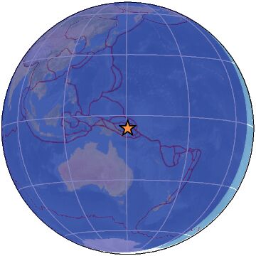
-
-
M 6.8 - Macquarie Island region
2024-03-03 16:16:59 (UTC)59.137°S 158.853°E10.0 km depthM 5.4 - south of the Kermadec Islands
2024-03-02 23:14:42 (UTC)32.509°S 177.668°W10.0 km depthEARTHQUAKE magnitud 5.8
A 427 km de Nasinu, Fiyi · 1 mar, 9:26 p.m.EARTHQUAKE magnitud 5.9
A 417 km de Hadiboh, Yemen · 1 mar, 2:29 p.m.5.0
Easter Island region
2024-03-03 12:56:32 (UTC-03:00)
10.0 km
5.1
117 km SSW of Pagar Alam, Indonesia
2024-03-03 12:07:42 (UTC-03:00)
62.2 km4.9
Owen Fracture Zone region
2024-03-03 02:35:37 (UTC-03:00)
10.0 km4.8
112 km WNW of Uken, Japan
2024-03-02 20:09:53 (UTC-03:00)
157.6 km
--------------------------------------------------------------------------PANAMA PLATELET
COLOMBIA REGION
https://www.facebook.com/100090002764334/videos/1861833780928536
Several of the people shaken by the tremor in Colombia today say that before the magnitude 4 earthquake they heard a strange and loud noise, as if it were an "explosion
-
-
Magnitude 6.3 Region SOUTHERN EAST PACIFIC RISE Date time 2024-02-23 01:51:14.8 UTC Location -35.058 ; -110.751 Depth 10 km Distance 3329 km W of Valdivia, Chile / pop: 133,000 / local time: 22:51:14.8 2024-02-22
888 km S of Hanga Roa, Chile / pop: 3,300 / local time: 20:51:14.8 2024-02-22Source parameters reviewed by a seismologist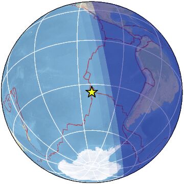
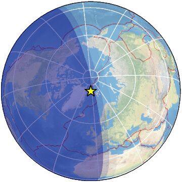
Magnitude 5.0 Region NORTH OF SVALBARD Date time 2024-02-23 05:35:13.5 UTC Location 81.143 ; -5.247 Depth 10 km Distance 1675 km WNW of Murmansk, Russia / pop: 319,000 / local time: 08:35:13.5 2024-02-23
523 km WNW of Longyearbyen, Svalbard and Jan Mayen / pop: 2,300 / local time: 06:35:13.5 2024-02-23Source parameters reviewed by a seismologist
-
-
Magnitude 5.1 Region OKLAHOMA Date time 2024-02-03 05:24:29.1 UTC Location 35.535 ; -96.734 Depth 6 km Distance 71 km ENE of Oklahoma City, United States / pop: 681,000 / local time: 23:24:29.1 2024-02-02
7 km NW of Prague, United States / pop: 2,400 / local time: 23:24:29.1 2024-02-02Source parameters reviewed by a seismologist
-
-
Magnitude 3.5
Region LOUISIANA
Date time 2024-01-27 20:39:00.7 UTC
Location 32.149 ; -93.315
Depth 5 km
Distance 58 km SE of Shreveport, United Stateshttps://www.emsc-csem.org/Earthquake_information/earthquake.php?id=...
---------------------------------------------------------------------
M 6.5 - 66 km W of Tarauacá, Brazil
2024-01-28 09:38:56 (UTC)8.215°S 71.367°W609.5 km depth
https://earthquake.usgs.gov/earthquakes/eventpage/us7000lui3/executiveFROM LINK A deep earthquake with a magnitude of 6.5 Richter and a depth of 609km struck West Tarawaka, Brazil.
It is the second earthquake of this magnitude to hit Brazil.
--------------------------------------------------------------------------------
Magnitude 4.4
Region WESTERN GREENLAND
Date time 2024-01-27 22:01:55.0 UTC
Location 62.453 ; -43.729
Depth 10 kmMagnitude 5.0
Region WESTERN TURKEY
Date time 2024-01-27 05:19:19.6 UTC
Location 37.980 ; 27.138
Depth 10 kmMagnitude 6.1
Region GUATEMALA
Date time 2024-01-27 05:52:48.9 UTC
Location 14.128 ; -90.563
Depth 101 km
https://www.emsc-csem.org/Earthquake_information/earthquake.php?id=...4.5
13 km N of Allende, Mexico
2024-01-28 06:57:09 (UTC-03:00)
10.1 km
4.9
114 km SSE of Kyzyl-Suu, Kyrgyzstan
2024-01-28 06:52:18 (UTC-03:00)
10.0 km4.5
26 km W of Bahía Solano, Colombia
2024-01-28 05:17:55 (UTC-03:00)
18.0 km
4.3
16 km NW of Panguipulli, Chile
2024-01-28 04:35:56 (UTC-03:00)
84.3 km5.4
170 km NE of Neiafu, Tonga
2024-01-27 13:13:58 (UTC-03:00)
20.8 k
-
-
Magnitude 5.5
Region KYRGYZSTAN
Date time 2024-01-24 01:35:20.8 UTC
Location 41.584 ; 78.624
Depth 7 km
https://www.emsc-csem.org/Earthquake_information/earthquake.php?id=...M 6.3 - 43 km SW of Port-Vila, Vanuatu
2024-01-23 14:33:46 (UTC)18.009°S 168.016°E37.2 km depth
https://earthquake.usgs.gov/earthquakes/eventpage/us7000lt73/executive4.8
35 km E of Loreto, Mexico
2024-01-23 22:48:32 (UTC-03:00)
10.0 km4.6
128 km SSE of Kyzyl-Suu, Kyrgyzstan
2024-01-23 20:50:06 (UTC-03:00)
10.0 km
4.7
36 km ESE of Rengo, Chile
2024-01-23 20:09:52 (UTC-03:00)
124.1 k5.1
67 km SSE of Akkeshi, Japan
2024-01-23 18:33:49 (UTC-03:00)
35.5 km
2.7
53 km S of Whites City, New Mexico
2024-01-23 18:02:27 (UTC-03:00)
7.2 km
5.2
134 km W of Aykol, China
2024-01-23 17:38:13 (UTC-03:00)
10.0 km
2.8
4 km WNW of Trimble, Tennessee
2024-01-23 17:14:31 (UTC-03:00)
3.5 km4.6
82 km WSW of Coquimbo, Chile
2024-01-23 13:06:55 (UTC-03:00)
10.8 km
4.9
Kermadec Islands, New Zealand
2024-01-23 13:06:23 (UTC-03:00)
124.9 km4.5
121 km SSE of Kyzyl-Suu, Kyrgyzstan
2024-01-23 10:47:18 (UTC-03:00)
3.1 km
4.6
115 km WNW of Aykol, China
2024-01-23 09:09:29 (UTC-03:00)
10.0 km
4.7
125 km WNW of Aykol, China
2024-01-23 06:24:48 (UTC-03:00)
10.0 km
4.6
127 km WNW of Aykol, China
2024-01-23 06:23:22 (UTC-03:00)
10.0 km
4.9
127 km SSE of Kyzyl-Suu, Kyrgyzstan
2024-01-23 06:07:13 (UTC-03:00)
10.0 km4.6
Izu Islands, Japan region
2024-01-23 01:30:59 (UTC-03:00)
10.0 km
5.0
201 km SE of Fakfak, Indonesia
2024-01-23 01:07:21 (UTC-03:00)
10.0 km
5.4
southeast of Easter Island
2024-01-23 01:02:42 (UTC-03:00)
10.0 km
4.8
111 km SSE of Kyzyl-Suu, Kyrgyzstan
2024-01-23 01:01:23 (UTC-03:00)
10.0 kmMagnitude 4.8
Region GULF OF CALIFORNIA
Date time 2024-01-24 01:48:34.8 UTC
Location 26.240 ; -110.568
Depth 13 km
-
-
Magnitude 7.0 Region SOUTHERN XINJIANG, CHINA Date time 2024-01-22 18:09:05.0 UTC Location 41.237 ; 78.752 Depth 9 km Distance 270 km SE of Almaty, Kazakhstan / pop: 2,000,000 / local time: 00:09:05.0 2024-01-23
128 km W of Aksu, China / pop: 535,000 / local time: 00:09:05.0 2024-01-23Source parameters reviewed by a seismologist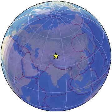
-
-
Magnitude 6.7
Region AMAZONAS, BRAZIL
Date time 2024-01-20 21:31:06.4 UTC
Location -7.253 ; -71.495
Depth 615 km
https://www.emsc-csem.org/Earthquake_information/earthquake.php?id=...M 6.2 - Southwest Indian Ridge
2024-01-20 22:09:39 (UTC)39.926°S 46.189°E10.0 km depth
https://earthquake.usgs.gov/earthquakes/eventpage/us6000m53t/executive
-
-
M 6.4 - 125 km NW of Fangale’ounga, Tonga
2024-01-18 22:12:20 (UTC)18.928°S 175.147°W218.1 km depth
https://earthquake.usgs.gov/earthquakes/eventpage/us6000m4js/executive
--------------------------------------------------------------------------4.5
30 km ENE of Anamizu, Japan
2024-01-18 15:04:39 (UTC-03:00)
10.0 km
4.6
93 km ENE of Poso, Indonesia
2024-01-18 15:02:59 (UTC-03:00)
10.0 km
5.2
92 km ENE of Poso, Indonesia
2024-01-18 14:36:20 (UTC-03:00)
46.8 km5.7
South Sandwich Islands region
2024-01-18 09:46:14 (UTC-03:00)
23.44.7
north of Franz Josef Land
2024-01-18 03:15:45 (UTC-03:00)
10.0 km5.3
South Sandwich Islands region
2024-01-18 02:12:14 (UTC-03:00)
54.1 km5.8
111 km WSW of Houma, Tonga
2024-01-18 01:50:01 (UTC-03:00)
155.0 km
© 2024 Created by 0nin2migqvl32.
Powered by
![]()
You need to be a member of Earth Changes and the Pole Shift to add comments!
Join Earth Changes and the Pole Shift