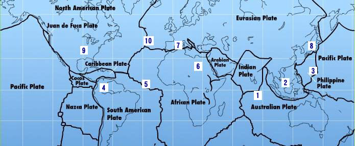
South American Roll Watch
Nancy Wrote on Holgraphic Presentation Last night...
http://www.zetatalk.com/newsletr/issue169.htm
"Over to S America the Andes are shown doing mountain building, while some islands in the Caribbean are sinking, their plate
pushed under as S America rolls."
In this particular Blog will be describes and take note of all the Earth Changes of the World that will lead to the Geological Movement of the South American Plate: about 250 miles/400.33 Km to roll!.
https://poleshift.ning.com/forum/topics/zetatalk-chat-for-december-...
-Caribbean Subducting under Northern South America:
7 of 10 - Safe Locations
https://poleshift.ning.com/profiles/blogs/7-of-10-safe-locations
- Cover, front and back
- Table of Contents and Introduction
- Homeless
- Settlement
- High Tech Note: continued in the next PDF document
- Communities
- Resources
- Addendum
And finally, the Zetatalk predictions for safe locations are 100% accurate.
Tags:
Replies to This Discussion
-
Permalink Reply by Recall 15 on July 28, 2011 at 6:51am
-
Argentina: massive landslide 2 hectares in Colonia Aurora, Misiones
Read More:
http://poleshift.ning.com/profiles/blogs/argentina-massive-landslide-2
-
Permalink Reply by Recall 15 on July 28, 2011 at 6:56am
-
Santa Rosa, Guatemala Swarm 598 Quakes in a Week
Read More:
http://poleshift.ning.com/profiles/blogs/santa-rosa-guatemala-swarm...
-
Permalink Reply by Recall 15 on July 28, 2011 at 7:15am
-
More Quakes:
Average Magnitude Event Displayed: . 4.76
Current Swarms at Guatemala, Gulf of Mexico, Chile
28-JUL-2011 01:19:30 13.52 -90.64 4.6 71.4 NEAR COAST OF GUATEMALA
27-JUL-2011 08:04:47 13.73 -90.59 4.1 70.8 NEAR COAST OF GUATEMALA
27-JUL-2011 05:59:18 14.81 -91.49 4.5 127.6 GUATEMALA !!!
27-JUL-2011 03:13:49 24.95 -109.52 4.0 9.9 GULF OF CALIFORNIAFrom:
-
Permalink Reply by Recall 15 on July 29, 2011 at 2:59pm
-
Caribbean Plate Border:
Dam Collapses in Dominica
Read More:
http://poleshift.ning.com/profiles/blogs/dam-collapses-in-dominica-...
-
Permalink Reply by Recall 15 on July 29, 2011 at 3:03pm
-
Mexico: flood affected 200 000 hectares of crops
Read More:
http://poleshift.ning.com/profiles/blogs/mexico-flood-affected-200-000
-
Permalink Reply by Recall 15 on July 31, 2011 at 4:43am
-
Mexico: new crack 4 kilometers in Chalco
Read More:
http://poleshift.ning.com/profiles/blogs/mexico-new-crack-4-kilometers
-
Permalink Reply by Recall 15 on July 31, 2011 at 4:49am
-
Mexico: "water reached a level of 40 inches"
Read More:
http://poleshift.ning.com/profiles/blogs/mexico-water-reached-a-level
-
Permalink Reply by Recall 15 on August 2, 2011 at 7:45pm
-
Honduras: Evacuation due to high flood levels of flow of Ulua / flow lvl of Ulua "have risen 6 m"
Read More:
http://poleshift.ning.com/profiles/blogs/honduras-evacuation-due-to
-
Permalink Reply by Recall 15 on August 2, 2011 at 7:45pm
-
El Salvador: Flood in Santa Ana / "the water level rose up to 85 inches"
Read More:
http://poleshift.ning.com/profiles/blogs/el-salvador-flood-in-santa...
-
Permalink Reply by Recall 15 on August 2, 2011 at 11:42pm
-
Caribbean Plate Border:
Not in Iris Database:
At 10:29 hours today, an earthquake of magnitude 4.1 on the Richter scale and intensity II on the Mercalli scale for the City of Guatemala, with its epicenter in the department of Santa Rosa, according to preliminaryseismological bulletin National Institute of Seismology, Volcanology, Meteorology and Hydrology-INSIVUMEH.
The quake occurred at an epicentral distance of 52.5 kilometers from the capital city in the region of the Santa Rosa and was reported sensitive in that department and in Guatemala City, said the scientific body of the System of National Coordinator for CONRED Disaster Reduction.From:
http://conred.gob.gt/index.php/boletines/informativos/1967-boletin-...
SEARCH PS Ning or Zetatalk
This free script provided by
JavaScript Kit
Donate
© 2024 Created by 0nin2migqvl32.
Powered by
![]()
